Stories of Guernsey County by Wm. Wolfe Pages 786-793
Chapter XXI
Adams Township
IN OUR stories of the townships we begin with Adams because it comes first, alphabetically considered. When called upon to name the townships of Guernsey county, pupils in the schools begin with Adams. Back in the days of the county political conventions the delegates from Adams township were the first to vote.
One of the Last Formed.—But Adams township was not the first to be organized; in fact, it was one of the last of the nineteen townships to be formed. The twenty-five square miles of territory of which it is composed were taken from Knox and Westland townships, between which it is situated. It was set apart by the county commissioners in 1827 and named Adams, not for John Adams, the second President of the United States, but for John Quincy Adams, his son, who was then president.
PhysicaL Features.—Adams township is drained by two streams—Crooked creek and Sarchet’s run, both of which empty into Wills creek. A ridge that is followed by the Lebanon road divides the waters of the two streams. Peter’s creek is the main tributary of Crooked creek, within the township. Crooked creek, as the name implies, is a meandering stream. Sarchet’s run takes its name from that of a family once living near its mouth. An incident that gave Peter’s creek its name is told in the chapter on Washington township.
Pioneers of the Township.—The early history of Adams township is a part of that of Knox and Westland. Zane’s Trace cut across the southeastern part of what is now Adams. It was on this road that the first settlers of the township located. Among the first, if not the first settler, was Stewart Speer, born in Pennsylvania in 1783. As early as 1808 he kept a tavern near the present Pike consolidated school. When the War of 1812 began, he enlisted and became a lieutenant in the company of Captain Simon Beymer. He was a member of the first Guernsey county grand jury, impaneled on August 27, 1810, and afterwards served as an associate judge of the county. Descendants of this pioneer are yet living in Adams township.
In 1815 Thomas Knox came with his parents from Pennsylvania, to what was then Westland, later Knox, but now Adams township. He was then sixteen years of age. A few years later he married Jane Miller, born in Ireland in 1800. In 1812 her family set sail for America. The ship was captured by the British and the Millers carried to Newfoundland, where they were held as prisoners until the close of the war, two years later. Here her mother died. From Newfoundland she came to Pennsylvania; afterwards, to what is now Adams township.
Another pioneer of the township, whose descendants are yet found in the county, was Samuel Mehaffey. Born in Ireland, he married Margaret Bingham there, and set sail for America in 1812. Their arrival in this county was on the very day war was declared against Great Britain (June 19, 1812). When in sight of New York their vessel was boarded by the officers of a British ship of war. Had the declaration of war been known to these officials, the Mehaffeys would have been taken prisoners, as were the Millers.
Among the heads of other Adams township pioneer families were Benjamin Reasoner, William McCulley, David Thompson, Alexander Leeper, Robert Bell, John Sunnafrank and Robert Boyd.
Old Folks of 1876.—A census of Guernsey county people seventy-six years or more of age, taken by The Jeffersonian in 1876, showed the following as living in Adams township; Abram Barnes, George Estep, Mrs. Estep, Joseph Gleur, Andrew Hamilton, John Hammond, Mrs. J. Hammond, Samuel Lee, Mrs. S. Lee, John Leech, Samuel Maxwell, Mrs. Maxwell, Samuel Patterson, Robert S. Ross, Mrs. Ross, Robert Simpson, James Sherrard, Mrs. Sherrard and Samuel Wells.
Population.—1830, 736; 1840, 866; 1850, 860; 1860, 804; 1870, 762; 1880, 806; 1890, 740; 1900, 717; 1910, 608; 1920, 574; 1930, 516.
It will be noted that there were 220 fewer people in the township in 1930 than there were a hundred years before.
Two towns were platted in Adams township—Cassel Station in the southern part, and Mantua in the northern. The latter, which lay partly in Knox township, was platted August 6, 1853, by Thomas P. Wilson and William P. Rose. The postoffice established at Cassel Station was called Galligher; the one at Mantua, Creighton. Both were closed many years ago. Excepting a few families in the western part, who receive their mail through New Concord, all the people of the township are served by rural mail carriers from Cambridge.
Lebanon.—Many Adams township people are United Presbyterians. Their church is Lebanon in the northwestern part of the township. It was established on April 24, 1824, with David Proudfit as its first pastor. It now is and always has been one of the leading rural churches of the county.
Among the pastors of this church during the first fifty years of its existence were Rev. Welch, Rev . Benjamin Waddle, Rev. Samuel Wallace and Rev. James Duncan. As early as 1838 there were seventy-three families connected with the church. The building now in use was erected in 1905. Several of its present members are descendants of the first settlers of that section and founders of the church.
Near the church is the Lebanon cemetery. There was once a Lebanon school but it has been closed and the pupils are now transported to a consolidated school. The section is widely known as the Lebanon community, and is reached from Cambridge by the Lebanon road, one of the best roads in the county, from which may be obtained a beautiful view of the surrounding country.
Dr. James Duncan.—The pastor of the Lebanon church in the 1850’s was Dr. James Duncan who was one of the first graduates of Madison College. Making his home at Mantua, he also preached at Mt. Hermon. He afterwards became known throughout the United Presbyterian church from coast to coast as one of its most eloquent pulpit orators. He possessed an outstanding style which was particularly picturesque and , it was said, wherever he went to preach he was reasonably sure of a full house.
In the fall of 1857 Rev. Matthew Henderson Williams resigned as president of Madison College. The board of trustees insisted that Dr. Duncan accept the position. He did so tentatively and drove from Mantua to Antrim, a distance of twenty or twenty-five miles, each Monday morning, reaching the college in time for the opening exercises at nine o’clock. On Friday afternoons he would return to Mantua and preach at each of his churches the following Sabbath. His two congregations were absolutely unwilling to part with their pastor and left the matter with the presbytery to decide. That body voted against releasing him from the pastoral oversight of Lebanon and Mt. Hermon, whereupon he declined the presidency of Madison College, having served, however, as acting president for several months.
It is generally agreed that he declination of Dr. Duncan to continue as president was the death knell of the college. The institution was heavily involved in debt. Along with his preaching ability Dr. Duncan possessed a rare administrative ability, and he might have been able to save the college from falling into the hands of its creditors. Rev. William Lorimer succeeded Dr. Duncan as president of Madison College. During his term the crisis came.
The last commencement was held September 1, 1859. Dr. Duncan delivered the anniversary address. The class was composed of five young men and one young woman. Four of the young men became prominent ministers, and the young woman became the mother of some of the most outstanding ministers and missionaries of the U. P. church—Rev. John McClenahan, D. D., of Chicago; Rev. William McClenahan, D. D., Missionary to Egypt; and Dr. Frank McClenahan, professor of Physics and Geology at Monmouth College.
Thomas P. Proudfit, salutatorian of the class, was the father of Dr. Charles P. Proudfit who recently served as pastor of the Cambridge United Presbyterian church and is now the general secretary of the Board of Education of the United Presbyterian Church of North America. Thomas P. Proudfit became one of the pioneer home missionaries and one of the first to serve in the great territory between the Mississippi River and the Rocky Mountains. He taught Latin and Greek and was the author of a number of books relating to the work of the United Presbyterian Church.
The male member of the class who did not become a preacher was Dr. John McBurney who chose to be an educator. A sketch of Dr. McBurney may be found in another chapter of this work.
Owners of Real Estate in 1840.—Following is a complete list of the real estate owners in Adams township in 1840. The number of acres owned by each and the section in which his farm was located are given.
Atkison, John, 163 acres, sec. 3; Blair, William (Heirs), 40 acres, sec. 12; Boales, John, 96 acres, sec. 2; Bell, George, 271 acres, sec. 12, 18 and 20; Bigham, Alex and John, 163 acres, sec. 3; Brown, John (Heirs), 203 acres, sec. 1; Bradford, John, 50 acres, sec. 12; Burke, Robert, 100 acres, sec. 9; Brown, Robert, 82 acres, sec. 5; Bennett, James, Jr. (Heirs) 62 acres, sec. 17; Bennett, James, Sr., 160 acres, sec. 16; Burrows, John, 160 acres, sec. 24; Boyd, William, 160 acres, sec. 24; Boyd, Robert, 180 acres, sec. 23; Buchanan, John, 164 acres, sec. 5; Barcus, Jesse, 160 acres, sec. 20; Brown, Robert (Heirs), 82 acres, sec. 5; Bell, Robert (Heirs), 160 acres, sec. 13; Boyd, James, 160 acres, sec. 14; Bigham, James, 40 acres, sec. 11; Beatty, Cyrus P. (Heirs), 160 acres, sec. 10.
Crooks, Henry, 160 acres, sec. 7; Crooks, John, 160 acres, sec. 7; Cochran, Alexander, 82 acres, sec. 7; Culbertson, William, 160 acres, sec. 7; Danley, Arthur, 160 acres, sec. 6; Duff, George, 155 acres, sec. 5; Forsythe, Elijah, 161 acres, sec. 25; Frazier, Alexander, 80 acres, sec. 13; Frazier, David, 160 acres, sec. 12 and 13; Ford, Robert, 80 acres, sec. 11; Gist, Thomas, 161 acres, sec. 2 and 3; Guthrie, Joseph, 107 acres, sec. 15; Guthrie, Thomas, 120 acres, sec. 15; George, Alexander, 69 acres, sec. 15; Gallienne, John, 80 acres, sec. 12.
Hammond, John, 40 acres, sec. 12; Hutchison, Nathan, 160 acres, sec. 19; Hutchison, James C. (Heirs), 60 acres, sec. 9; Harper, Samuel, 161 acres, sec. 16; Johnson, James, 160 acres, sec. 8; Johnson, Abraham, 80 acres, sec. 12; Kilgore, Daniel, 159 acres, sec. 6; Knox, Thomas, 114 acres, sec. 4; Knox, James, 158 acres, sec. 7; Keeran, John (Heirs), 159 acres, sec. 21; Kennedy John, 100 acres, sec. 17; Leeper, Samuel, 7 acres, sec. 23; Leeper, Alexander, 152 acres, sec. 23; Long Frederick (Heirs), 50 acres, sec. 4; Law, William, 164 acres, sec. 4; Little, James, 160 acres, sec. 25; Leech, Matthew, 160 acres, sec. 17; Latimore, William, 160 acres, sec. 17; Laird, David, 20 acres, sec. 22; Leech, John, 175 acres, sec. 12 and 13; Leeper, William, 140 acres, sec. 19 and 23.
Mackey, Robert, 160 acres, sec. 8 and 9; Mackey, Richard, 320 acres, sec. 8; Mitchell, Alexander, 240 acres, sec. 11 and 19; Mehaffey, Samuel, Jr., 200 acres, sec. 10 and 11; McKnight, Samuel, 80 acres, sec. 11; Mehaffey, Samuel, Sr., 160 acres, sec. 9; Mehaffey, Robert, 120 acres, sec. 9; Mehaffey, John, 185 acres, sec. 18; Mancup, John, 139 acres, sec. 22; McKnight, Jacob A., 160 acres, sec. 18; McClusky, Henry, 83 acres, sec. 15; McDonough, Patrick, 160 acres, sec. 19; Miller, James, 155 acres, sec. 5; McIlyar, Thomas, 100 acres, sec. 11 and 20; Mehaffey, James, Sr., 120 acres, sec. 8 and 9; McGonagle, James, 106 acres, sec. 2; Marshall, William, 119 acres, sec. 18; McMichael, Eleanor, 40 acres, sec. 12.
Powell, William S., 75 acres, sec. 1; Porter, James, 123 acres, sec. 3; Priaulx, Nicholas, 80 acres, sec. 11; Priaulx, John, 120 acres, sec. 11 and 20; Parks, Hugh, 160 acres, sec. 14; Patton, William, 160 acres, sec. 17; Parkhill, James (Heirs), 160 acres, sec. 25; Patterson, Joseph, 163 acres, sec. 1; Paxton, William, 20 acres, sec. 23; Paxton, John (Heirs), 160 acres, sec. 15; Rogers, Michael, 160 acres, sec. 10; Russell, Thomas, 159 acres, sec. 6; Ross, Robert A., 164 acres, sec. 4; Reasoner, Benjamin, 161 acres, sec. 25; Rankin, John, 160 acres, sec. 21; Rose, John, 80 acres, sec. 9.
Smith, Alexander, 160 acres, sec. 6; Smith, Owen, 161 acres, sec. 16; Scott, Francis, 40 acres, sec. 12; Simpson, Joseph, 80 acres, sec. 11; Suitt, Philip, 220 acres, sec. 20; Stevenson, George, 120 acres, sec. 15; Stone, Frazier, 160 acres, sec. 24; Steele, John, 164 acres, sec. 4; Sherrard, James, 120 acres, sec. 2; Sherrard, William, 160 acres, sec. 10; Snodgrass, Jesse, 160 acres, sec. 23; Sleeth, David, 80 acres, sec. 10; Stevenson, Moses (Heirs), 80 acres, sec. 24; Sunafrank, John, Jr., 85 acres, sec. 21; Sunafrank, John, Sr., 160 acres, sec. 21; Sunafrank, Jacob, 160 acres, sec. 20; Spear, Alexander, 160 acres. Sec. 18; Spear, Abraham, 160 acres, sec. 22; Spear, Stewart, 396 acres, sec. 21, 22 and 23.
Thompson, Mary F., 41 acres, sec. 3; Thompson, David, 160 acres, sec. 16; Toner, Charles, 160 acres, sec. 14; Vorhies, John, 20 acres, sec. 2; Vorhies, Robert, 20 acres, sec. 2; Vincent, John, 160 acres, sec. 7; Wagstaff, William, 80 acres, sec. 3; Wells, Samuel, 200 acres, sec. 2; Wilson, Robert, 140 acres, sec. 19; Woodburn, Alexander, 113 acres, sec. 1; Woodburn, Hugh, 50 acres, sec. 1.
Geographical History of Lebanon Churchyard
Originally in Washington County.—On the Coshocton road, in Adams township, is a plot of ground which, from a geographical standpoint, has had many locations. This is the Lebanon churchyard. This same change in geography is true of a number of farms in that section.
The Lebanon churchyard was once located in Washington county, Ohio, whose county seat is Marietta. When that county was formed in 1788, it comprised more than the eastern half of the present state of Ohio. All the territory that is now Guernsey county was in Washington county.
Located in Muskingum County.—The Lebanon churchyard was once located in Muskingum county, Ohio, whose county seat is Zanesville. However, all of Guernsey county was not thus located. Muskingum county, as a separate political unit, was carved out of Washington county in 1804. Muskingum county was much larger than it is today, including all of what is now Guernsey county, excepting the three eastern townships—Londonderry, Oxford and Millwood. These were in the Seven Ranges and belonged to Belmont county.
Now a Part of Guernsey County.—When Guernsey county was formed in 1810, the Lebanon churchyard then came into another county where it has since remained. Its county locations have thus been as follows; Washington, 1788 to 1804; Muskingum, 1804 to 1810; Guernsey, 1810 to present time.
Deeds granted to purchasers of Military land in Guernsey county prior to 1804—and some land was purchased then—were recorded in Marietta.
Those granted between 1804 and 1810 were recorded in Zanesville. After Guernsey county had been organized and an office of record established here, copies of some of the records on file in Marietta and at Zanesville were brought to
Cambridge and placed in the recorder’s office. The fact that all were not thus transferred has made it necessary for many who wish information concerning land changes made before 1810, to seek it where first filed.
In Westland Township.—The Lebanon churchyard was once located in Westland township, but today it is several miles from that division of Guernsey county. At the time of the formation of the county it was ordered that it be divided into five townships, namely, Cambridge, Oxford, Westland, Seneca and Wills. All the western part was called Westland which, of course, included Lebanon churchyard.
Located in Knox Township.—As the population of the county grew, the five original townships yielded some of their territory for the formation of other townships. Westland was divided, the northern part becoming Wheeling. Then in 1819 the northern part of what was left of Westland, and the southern part of Wheeling were cut off and joined for a new township that was called Knox. The Lebanon churchyard being located in the northern part of Westland, then found itself in Knox township.
Now in Adams Township.—Here it remained until 1827, when Adams township was created. Westland was again called upon to yield some more of its territory. The northern part was cut off and joined to the southern part of Knox, thus forming Adams township. That part of Knox in which the Lebanon churchyard is located was taken, resulting in its being changed to Adams township. Here it has since remained.
Summarized, the plot of ground known as the Lebanon churchyard has been a part of Washington county, Muskingum county, Guernsey county, Westland township, Knox township and Adams township, distinct political units, of which some are far removed form the others. And the Lebanon churchyard has always remained in the same place.
William Oxley Thompson
In the Peter’s Creek school district of Adams township William Oxley Thompson, son of David G. and Agnes M. (Oxley) Thompson, was born on November 5, 1855. The father was a veteran of the Civil War; the mother was a woman of strong character and much intelligence.
Moves to Cambridge.—At the time William O. was born David G. Thompson was engaged in farming, but being a shoemaker, he soon after moved to Cambridge to work at his trade. Here William O. started to school, his mother being his first teacher. To assist in the support of the family she taught the primary room of the Cambridge schools, then located in the old Masonic building on North Seventh street.
There eventually came to be ten children in the family, of which William O. was the oldest. Eager for a higher education, he entered Muskingum College in 1870. In 1878 he graduated as the honor member of his class. He worked his way through school in the truest sense of that oft used expression. Not only could the family not help him, but he helped support the family at the same time he was struggling for an education. He gave eight years to the completion of a college course that he easily could have finished in four.
Taught in Oxford Township.—During his eight years of college he would drop out frequently to earn money by which to continue his studies. He worked as a farm hand at eight dollars a month, and he taught in rural schools. One of the schools in which he taught was known as “No 4” in Oxford township, a mile southwest of Fairview. Forty years afterwards he visited this little school and donated to it a part of his personal library. In his honor the name of the school was changed to “Thompson.” The schools of the township were later consolidated and this building was removed.
President of Ohio State University.— After graduating from Muskingum College Thompson entered the Western Theological Seminary (a Presbyterian school) at Allegheny, Pennsylvania, from which he graduated in 1882. After preaching a few years at Odebolt, Iowa, and Longmont, Colorado, he came to Oxford, Ohio, as president of Miami University. Eight years later (1899) he was chosen president of Ohio State University at Columbus. Here he served until 1925, when he retired of his own accord. During his administration this institution grew from an enrollment of 1,200 to 12,000 students, thus becoming one of the greatest universities in America.
Dr. William O. Thompson was a leader in the field of education. In 1927 he was chosen Moderator of the General Assembly of the Presbyterian Church in the United States. By the chief executives of both Ohio and the United States he was appointed a number of times to serve on important commissions. His counsel was sought in matters of school, church and state. The universal regard in which he was held was outstanding. Contributing to this were several characteristics of the man.
A Natural Leader.—Dr. Thompson was a natural leader. He displayed a boundless energy throughout his entire life. He took an active part in many movements, aside from his regular work, that to him seemed designed for the betterment of society. Possessed of a pleasing voice, and sympathetic and frank in conversation, he became a friend to all whose privilege it was to meet him. His death occurred on December 9, 1933.
~~~~~~~~~~~~~~~~~~~~~~~~~~~~~~~~~~
Stories of Guernsey County by Wm. Wolfe Pages 794-806
CHAPTER XXII
Cambridge Township
THE history of Cambridge township is so interwoven with that of Cambridge city that most stories of the two are inseparable. For them the reader is referred to the chapter, entitled “Cambridge Stories.” This chapter is devoted largely to the territory of the township lying outside the city limits.
Formation.—It was one of the original townships established by the county commissioners at their organization meeting held at he house of George Beymer, April 23, 1810. It took its name from the town laid out in 1806, and called Cambridge by Jacob Gomber, it is said, after Cambridge, Maryland, from which some of the settlers had come.
At first the township was much larger than it is today. Territory has been taken from it at different times to help form other townships. Its area is now about thirty-five square miles. The township is nearly rectangular in form, seven miles long and five miles wide. A small strip cut from the southeast corner and given to Jackson when that township was formed, was balanced by the same area from center, into which Cambridge township projects. This irregularity in boundary lines has caused much confusion in the administration of township and school affairs.
Cambridge township lies within the Military land district and was surveyed by Zaccheus Biggs, a deputy surveyor of the federal government, in 1798. At that time what is now Cambridge township was in Washington county. In 1804 it became a part of Muskingum county and the land was sold at the government land office in Zanesville. The original deeds of most Cambridge township farms bear the words, “of lands directed to be sold at Zanesville.” The price paid was less than two dollars an acre.
Physical Features.—Like all other townships of the county Cambridge is composed of hills and valleys. Meandering from south to north is Wills creek. To make the seven miles across the township it winds back and forth over a distance of twelve miles. In at least one place it flows nearly south for a mile. The fall is slight, and due to this and the many bends there are frequent inundations of the bottom lands. Leatherwood, its principal tributary from the east in the township, enters Wills creek at Cambridge. Crooked creek from the west empties into Wills creek north of Cambridge, as does Sarchet’s run from the same direction.
Natural Resources.—Cambridge has a variety of valuable mineral resources unsurpassed in any other township of the county. The southeast quarter is underlaid with what is known as coal vein No. 7, of the Cambridge coal field. This vein crops out at Cambridge, and east of the city is so near the surface that much coal has been mined by the process of stripping. The Scott mines, the first to be operated in the county on an extensive scale, were located in this township. Underlying all the township are veins No. 6 and No. 5, the former at an average depth of about 100 feet. No.5 is about fifty feet below No. 6. Some coal has been taken from the former at Pigeon Gap north of the city.
As early as 1861 there was some drilling for oil in the township. The wells were shallow, but some gas was found. However, as it was oil that was wanted, little attention was paid to the gas. Drilling for salt water on his farm three miles north of Cambridge, David Sarchet, in 1870, struck gas that was sufficient, it was said, to light the entire town of Cambridge, but it was not utilized. Some years later the Cambridge Light and Fuel Company sank three wells in Cambridge township, from which there was a fair yield of gas. However, there was much trouble from salt water. During the gas and oil excitement of 1926-27 several profitable wells were drilled in the western part of the township. Since than another field has been opened in the northern part. Some of the wells have yielded oil in paying quantities.
Clay is another valuable natural resource of the township. The type of clay found here is well suited for the manufacture of brick tile and pottery products. One of the largest salt-works in Southeastern Ohio was located near the eastern edge of the township seventy-five years ago.
A Cambridge Township Pioneer.—In the summer of 1805 a young man walking westward along Zane’s Trace, with an ax and a gun on his shoulder, reached the Wills creek crossing in what is now Cambridge. For several days he had been walking alone through a nearly uninhabited country, seeking a suitable location for a future home. His name was Isaac Oldham. He was born in Pennsylvania in 1779, but when a boy had moved with his father to Virginia.
On the day before starting on this western journey he had married Sarah Marling, who was born and reared in Maryland. He had no money with which to buy a home in Virginia for his bride. He heard that in Ohio, which had been admitted to the Union two or three years before, excellent land could be obtained from the government at a small cost per acre. Leaving his young wife at her father’s home, he set out alone, promising to return for her as soon as a suitable location could be found and made a fit place for her to live.
At the Wills creek crossing when Oldham arrived, there were two or three log cabins occupied by members of the Beatty family which included Jacob Gomber, George Metcalf and Wyatt Hutchison. Except a small clearing around the cabins all the territory within the present boundaries of Cambridge was a forest which, almost unbroken, extended far in every direction. On his arrival Oldham learned that Jacob Gomber and Zaccheus A. Beatty were planning to lay out a town. He liked the country and decided to remain for a time, meanwhile looking about for a suitable place to locate. He assisted Gomber and Beatty in their work which was difficult because of the trees, the underbrush and the hollows on what are now Wheeling and Steubenville avenues. One hundred forty lots were staked off and offered for sale.
But Isaac Oldham did not want to locate in town. He wanted a farm. It was his privilege to choose almost any location he pleased and as many acres as he wanted, at one dollar and twenty-five cents an acre, to be paid for at the land office in Zanesville. We may suppose that he roamed the woods in every direction, looking for the most desirable place to settle in what is now Guernsey county. He chose a location in the broad Wills creek valley north of the newly-platted town. It was second-bottom land, fertile, free from floods and well drained.
He purchased 160 acres from the government. With the ax which he had carried with him from Virginia he cut such logs as he could handle alone, and raised a cabin near a strong spring of water. The floor of the cabin was the earth. The roof was clapboards weighted with poles. No door was hung, neither were the crevices between the logs chunked and daubed with clay. A bed was made by driving a forked stake in the ground near one corner of the cabin, from which poles extended to the crevices in the walls. Upon the poles a tick filled with leaves was laid. For a table he used a split section of a log into which four legs were driven. Blocks of wood served as chairs.
An Old Apple Tree.—After Isaac Oldham had built his cabin and cleared a patch of ground around it, he went back to Virginia for Sarah, his wife. It was February, 1807. His visit at the old home was necessarily short because there was much work to do in the clearing. The return was over Zane’s Trace, but this time he did not walk. Both he and Sarah rode horses, carrying a few articles to be used in housekeeping. Sarah’s folks were out to bid them good-bye and wish them Godspeed. Remarking that she needed a riding switch, her father pulled a small sprout form the root of an apple tree standing near and handed it to her. She used it as such throughout the long journey. When she reached the cabin in the clearing she noticed some small roots hanging from the end of the switch. Hoping that it might grow, she planted it below the cabin.
And it did grow and has continued to grow since that day, exactly 135 years ago last February. It is the oldest apple tree in Guernsey county—probably the oldest in the state of Ohio. A few years after Sarah planted the tree it began bearing apples. They were what are called “common fruit,” yellowish and somewhat sour, and they ripened in the late summer. Each year for a century and a third the tree has borne its crop of fruit. At this time (August, 1942) there are apples on the tree.
Standing on the exact spot where Sarah planted it, this venerable apple tree is showing the effects of long endurance and faithful service. As might be expected it long ago assumed an appearance of decrepitude. The main trunk is hollow and the branches are gnarled. The trunk is eight feet three inches in circumference one and a half feet from the ground. The tree is approximately thirty feet in height.
The Stone House.—Isaac and Sarah Oldham occupied the cabin until 1822 when they erected a new home on the site of the old. This was built of stone quarried from an adjacent hill. In the highceiling basement with massive hand-hewn beams was a wide wood fireplace. The interior finishings above were dressed by hand. While living in the cabin Oldham built a large log barn (thirty feet by sixty feet). This barn is in use today.
The Oldham Family.—When Isaac and Sarah Oldham began housekeeping in the log cabin they had no neighbors nearer than the settlers at Cambridge and the Indians at the Indian town less than a mile north of them. Wild beasts were numerous in the woods. Precaution was necessary both night and day. Isaac was once pursued from the clearing to the very door of the cabin, by a large panther. The Indians were friendly the most of the time and frequently gave them fish and game.
Isaac Oldham died in 1851, and Sarah in 1865. Both were buried in Cambridge. To them nine children were born. More land was added to the original 160 acres until the Oldham farm became one of the largest in this section. On it is Oldham’s grove where picnics used to be held annually. Marling Oldham, one of the sons, built a large brick house near by. His son, Isaac J. Oldham, married and went to live in the old stone house, and here he died in 1939 at the age of 82. The old stone house is now occupied by his daughter, Mrs. Clara E. Mason, and her son, Edgar O. Mason, the latter being the great-great-grandson of the original Isaac Oldham.
Owners of Real Estate in 1840.—One hundred years ago (1840) the following persons owned real estate in Cambridge township, outside of the incorporated village of Cambridge. The list is complete.
Arthur, John, 62 acres, lot 20; Albright, Benjamin A., 22 acres, lot 33; Allison, William, 322 acres, sec 3; Allison, Robert, 400 acres, sec. 24 and 25; Arndt, Charles, 59 acres, lot 21; Baltzell, Jacob, 32 acres, lot 10; Bryson, Abraham, 98 acres, sec. 5; Beatty, John P., 2 acres, lot 37 Boyd, Joseph, 120 acres, sec.5; Bratton, Samuel, 100 acres, sec. 1; Bratton, James, 62 acres, sec. 1; Bell, William, 154 acres, sec. 4 and 5; Burton, Joseph (Heirs), 100 acres, lot 7; Blair, James, 80 acres, sec. 11; Bichard, Daniel, 160 acres, sec. 23; Broom, Hugh, 401 acres, sec. 2, 3, and 22; Beatty, Cyrus P. (Heirs), 240 acres, sec. 2 and 3; Blanpeid, Elisha, 162 acres, lot 18; Black, Samuel, 200 acres, lot 1; Burton, Daniel (Heirs), 115 acres, lot 31; Bragg, John (Heirs) 40 acres, sec. 9; Blair, John, 80 acres, sec. 10; Britton, Joseph, Jr., 97 acres, lot 28; Blair, James, 1 acre, sec. 5; Beymer, William, 90 acres, sec. 3; Blair, Alexander, Jr., 62 acres, sec. 5; Blair, Alexander, Sr., 40 acres, sec. 7; Bell, Robert, 65 acres, sec. 25; Baughman, William, 41 acres, sec. 4; Barr, James, 80 acres, sec. 7.
Clements, James, 40 acres, sec. 7; Chapman, John (Heirs), 681 acres, sec. 3 and lot 30; Dodds, Archibald, 80 acres, sec. 3; Davis, John, 81 acres, sec. 3; Dunheiffer, Jacob, 9 acres, lot 20; Davis, Zadock, 269 acres, sec. 5; Enty, Elias, 20 acres, lot 7; Foy, William, 160 acres, sec. 10; Ferbrache, Jacob, 81 acres, sec. 2; Findley, Samuel, 160 acres, sec. 22; Ford, Robert, 123 acres, sec. 15; Ferbrache, Daniel, 81 acres, sec. 2; Ferguson, William, 14 acres, lot 30; Funk, Hosea B., 124 acres, lots 11 and 22; Green, Jacob, 41 acres, sec. 5; Gillett, Comfort, 65 acres, sec. 3; Gilpin, John, Sr., 41 acres, sec. 5; Griffin, Samuel, 1 acre, lot 40; Gray, James, 82 acres, lot 6; Galligher, John, 40 acres, sec. 3; Graham, William, 210 acres, lot 12.
Hughes, Henry P., 93 acres, lot 39; Hunt, David, 16 acres, lot 2; Harris, William, 40 acres, sec. 11; Hyatt, Noah, 73 acres, lot 41; Huffman, John, 160 acres, sec. 9; Hurst, John, 15 acres, lot 22; Hammond, David P., 80 acres, sec. 6; Holler, Sarah, 8 acres, lot 6; Hutchison, Robert (heirs0, 125 acres, sec. 5; Hill, Richard, 113 acres, sec. 1; Hill, James (Heirs), 50 acres, sec. 1; Hanna, John, 160 acres, sec. 21; Hutchison, Corbin, 80 acres, sec. 9; Hutchison, Enoch, 1 acre, lot 41; Hinds, Abraham, 79 acres, lot 15; Johnson, Jesse, 92 acres, sec. 6; Kennedy, Nathaniel, 80 acres, sec. 4.
Lenfesty, Thomas, 80 acres, sec. 11; Lepage, Thomas, 140 acres, sec. 6 and 15; Lofland, Gordon, 436 acres, sec. 14 and lots; Long, Jacob, 80 acres, sec. 3; McConaughy, John, 40 acres, sec. 11; McMurry, James, 150 acres, lot 15; McCluny, Nichols, 80 acres, sec. 25; McCoy, Daniel, 66 acres, sec. 5; McKee, Eleanor, 41 acres, sec. 5; McKee, John, 41 acres, sec. 5; McDonald, Daniel, 80 acres, sec. 5; McCrory, Lavinia, 40 acres, sec. 9; Masefield and Noble, 162 acres, lots 22 and 23; McConaughy, Nancy, 81 acres, sec. 4; Moore, Robert B., 650 acres, sec. 2 and lots; Moore, James B., 81 acres, lot 24; McCrory, William, 160 acres, sec. 9; McConaughy, James, 5 acres, lot 13; McConkey, Samuel, 162 acres, lot 16; McMurry, Robert, 610 acres, sec. 12 and lots 3 and 9; McNary, Thomas (Heirs), 160 acres, sec. 10; McMurry, Peter, 200 acres, lots 23 and 27; Maffitt, Robert, 100 acres, lot 36; McIlyar, William, 50 acres, lot 8; Metcalf, Jacob G., 12 acres, lot 15; Marling, John, 160 acres, sec. 21; Morrison, Samuel, 180 acres, sec. 14 and 15; Mehaffey, John, 125 acres, sec. 6; McKee, Robert, 41 acres, sec. 5; Maxwell, David, 40 acres, sec. 4; Milliner, Grammer, 20 acres, lot 10; McMurry, William, 87 acres, lot 2; Metcalf, George, 646 acres, lots 13, 14, 20 and 21; McCracken, William, 690 acres, sec. 13 and lots 3 and 4.
Noble, Thomas, 121 acres, sec. 5 and 10; Neeland, Joseph, 243 acres, lots 6 and 7; Nevin, John D., 80 acres, sec. 4; Nelson, John, 160 acres, sec. 22; Nossett, Samuel, 41 acres, sec. 5; Newman, John, 40 acres, sec. 4; Nicholson, Robert, 339 acres, sec. 3 and lots; Nelson, Benjamin, 41 acres, sec. 5; O’Haver, Nathan, 50 acres, lot 26; Ogier, William, 170 acres, sec. 7 and 11; Oldham, Samuel H., 106 acres, sec. 4; Oldham, Isaac, 395 acres, sec. 3, 4 and 22; Ogier, Thomas, 160 acres, sec. 8; Oldham, Isaac (Heirs), 96 acres, sec. 4; Oliver, John, 87 acres, sec. 4; Oldham, Thomas (heirs), 302 acres, sec. 3, 4 and 8; Porter, J. N., 160 acres, sec. 9; Patterson, Jeremiah (Heirs), 60 acres, lot 17; Parkinson, Edward, 160 acres, sec. 21.
Riggs, Evan, 41 acres, sec. 5; Rose, Thomas, 40 acres, lot 38; Richardson, Robert D. (Heirs), 91 acres, lot 25; Rollins, Jonathan, 80 acres, sec. 6; Roseman, Edward, 95 acres, lot 8; Robinson, John (Heirs), 88 acres, lot 26; Rollingston, John, 81 acres, sec. 1; Rollston, James, 120 acres, lot 32; Reeves, Manesseh (Heirs0, 80 acres, sec. 10; Rinehart, Levi, 179 acres, lots 7 and 11; Ross, Theodore, 32 acres, lot 38; Souders, Jacob, 41 acres, sec. 4; Scott, Alexander (Heirs), 100 acres, lot 8; Sigman, Luke, 300 acres, lots 8, 9 and 10; Stokely, Samuel, 166 acres, sec. 8; Scott, Charles, 252 acres, lots 5 and 7; Scott, Mary, 164 acres, sec. 1; Sarchet, Thomas, 260 acres, sec. 24; Sarchet, Moses, 571 acres, sec. 15 and 24 and lots 2 and 3; Sarchet, David, 160 acres, sec. 24; Sarchet, Peter B., 160 acres, sec. 23; Sarchet, Nicholas, 120 acres, sec. 8; Shields, John, 80 acres, lot 22; Sigman, John, 184 acres, sec. 5 and lot 6; Sigman, George, 84 acres, sec. 5; Stewart, Thomas, 160 acres, sec. 2; Stone, Solomon, 100 acres, sec. 5; Stewart, James, 160acres, sec. 10 and 11.
Tingle, George B., 135 acres, lot 27; Tracy, William, 9 acres, lot 28; Underhill, Samuel, 80 acres, sec. 6; Unbour, Owen, 10 acres, lot 10; Wallace, Alexander, 80 acres, sec. 3; Wallis, Thomas, 130 acres, sec. 25; Wine, John, 4 acres, lot 19; Watson, David, 21 acres, lot 17; Wright, James, 160 acres, sec. 12; Walker, James, 160 acres, sec. 21; Wine, Emanuel, 6 acres, lot 18; Wilson, Josiah, 161 acres, sec. 5; Walters, William, 81 acres, sec. 1; Watson, Lewis,81 acres, sec. 2; Watson, James (Heirs), 81 acres, lot 17; Waller, Samuel (Heirs), 80 acres, sec. 4; White, Joseph W., 82 acres, sec. 5.
A census of persons more than seventy-six years of age, taken by the Jeffersonian in 1876, gave the following as living in Cambridge township, including the village of Cambridge:
John B. Ambler, Mrs. John B. Ambler, John Adams, Thomas Arneal, John Burt, Mrs. John Burt, Elisha Blampied, Mrs. Elisha Blampied, Samuel Barber, George Beam, Samuel Brown, Rachel Beatty, John Brown, Mrs. Maria Brown, Francis Boyce, Alexander Cochran, Mrs. Alexander Cochran, Malcolm Cameron, Mrs. S. Cameron, Alexander Cameron, Mrs. Alexander Cameron, James Dillon, Benjamin Downer, Mrs. Benjamin downer, Zadoc Davis, Joseph Fordyce, David Frazier, Thomas Ferbrache, James Ferbrache, Thomas Forsythe, Abraham Gaskill, Hiram Gibson, Mrs. H. Harris, David Hammond, Mrs. David Hammond. Noah Hyatt, George Jones, Henry Jackson, Jacob Long, Andrew Moore, John McGiffin, James B. Moore, Mrs. McIlyar, William McManaway, Ebenezer McKitrick, James McKitrick, Mrs. James McKitrick, James Messer, David Maxwell, James R. Moss, Sidney Maris, Mrs. Charles Moore, John MChaffey, James Needham, Samuel Oldham, Mrs. Judith Ogier, Peter Ogier, Thomas Pool, Stephen Potts, Mrs. Stephen Potts, William Palmer, William Rainey, Robert Rankin, Mrs. E. Rankin, Mrs. Ruckle, John Rainey, George Rose, James Sawhill, Mrs. James Sawhill, George Stevenson, David Sarchet, J. Sankey, Mrs. J. Sankey, John Stage, Joseph D. Tingle, Evaline Tingle, Rev. Williamson, Joseph Waller, William Wagstaff, Mrs. William Wagstaff, William Walters, Mrs. William Walters.
Township Population.—Cambridge municipality is not included in the following. As the township and town populations were not listed separately in 1820 and 1840, the figures here given for those years are estimates.
1820, 338; 1830, 841; 1840, 1,233; 1850, 1,447; 1860, 1,524; 1870, 1,283; 1880, 1,782; 1890, 1,825; 1900, 1,650; 1910, 2,360; 1920, 3,431; 1930, 2,270.
Roads and Railroads.—Cambridge township has three federal highways crossing it, a distinction that can be claimed by only a few townships in the state. Running from east to west is the National Road (No. 40); from north to south, the Cleveland-Marietta road (N0. 21); from northeast to southwest, the William Penn highway (No. 22). They intersect in the city of Cambridge.
Following nearly the same course as the National Road, Zane’s Trace was cut through the township in 1798. This was afterwards improved and called the Wheeling road. The National Road took its place in 1828.
In 1801 Edward Carpenter, for the sum of three hundred dollars, blazed a trail through the forest from Big Stillwater creek in what is now Harrison county to within seven miles of the Wills creek crossing where Ezra Graham and the Beymers were operating a ferry. Three or four years later it was continued through the present Cambridge township to the crossing. In 1811 it was improved, and became a wagon road through Cadiz to Steubenville. For more than as century it was known as the Steubenville road. In 1930 it became a part of the William Penn highway. (For the history of the Steubenville road see Chapter VI.)
The township is crossed by two railroads intersecting at right angles in Cambridge. Work on the Baltimore and Ohio, originally the Central OhioRailroad, was begun in Cambridge township in 1852 and completed in 1854. A line of the Pennsylvania system, known at first as the Marietta and Pittsburgh, later as the Cleveland and Marietta Railroad, was built through the township in 1873.
The Township Schools.—As told in the chapter of this work, entitled “Schools and Education,” free public schools were authorized in Ohio in 1821. The people were evidently slow in exercising the authority granted them, for, in 1825, a law was enacted requiring free public schools to be established and taxes levied for their support.
Following the enactment of this law Cambridge township was divided into districts, each of which was a taxation unit for the support of its school. In each district were three school directors. The town of Cambridge, then unincorporated, was partly within the boundaries of district No. 7, which extended from the public square to the Adams township line. One of the early teachers in this district was Andrew Magee who afterwards enters the ministry and, for several years, was the pastor of the Methodist Episcopal church in Cambridge.
Miss Anna McBurney, daughter of the late Dr. John McBurney, presented the writer an interesting document that had been preserved by her father. It reads as follows:
“Article of Agreement concluded February 5, 1833, between Joseph Bute, John B. Thompson and John Hersh, Jr., directors of school district No. 7, in Cambridge township, Guernsey county, Ohio, of the one part, and Andrew Magee, teacher, of said township, county and state, of the other part, as follows, to wit:
“The said Joseph Bute, John B. Thompson and John Hersh, Jr., directors as aforesaid, agree to employ the said Andrew Magee, as teacher of a common school in said district, for the period of three months, commencing on the 12th day of February (inst.) and ending on the 12th day of May next, free for the admission of all such children between the ages of four and twenty-one years, in said district, as may avail themselves of the privilege of attending the same, agreeably to the 34th Section of the Ohio School Law, and, in consideration of his services as teacher of said school, which he hereinafter binds himself faithfully and diligently to perform, they do hereby engage to pay over to the said Magee, at the close of such quarter (on the 12 day of May next), the sum of seventy-five dollars, out of the school funds belonging to said district.
“And the said Andrew Magee, on his part, hereby covenants and agrees with the said directors that he will teach in said school for said period of three months, the several branches of an English education specified in the certificate of qualifications granted by the board of school examiners of Guernsey county to said Magee, according to the best of his ability, to keep the same open for school excises, from 8 to 12 o’clock in the forenoon, and from one to 4 o’clock in the afternoon of each day of the week, Saturday afternoon excepted from the 12th day of February (inst.) until the 1st day of April next, and from 8 to 12 o’clock in the forenoon and from half past one to 5 o’clock, in afternoon of each day as aforesaid, thereafter, until the close of the quarter on the 12th day of May next, to provide at his own cost for use of said school, during said period of three months, the room, desks and fuel necessary, and, moreover, to use all reasonable diligence and attention towards the improvement of those attending the school.
“And it is covenanted between the parties to this instrument, that the school aforesaid shall, during the said period of three months, be at all times subject to the superintendence and examination of said directors, who may visit the same for the purpose of inspection, as often as they may think it expedient to do so, and direct such regulations to be adopted for its administration as they may consider necessary and just, and that said Magee shall be subject to the same, provided that nothing herein contained shall be construed so as to empower them to require from the said Magee the performance of any act or acts inconsistent with any of the terms of this agreement.
“In testimony whereof the aforesaid parties have hereunto set their respective hands, on date above written.
“Joseph Bute
“J. B. Thompson
“John Hersh, Jr.
“Andrew Magee.”
Barnes’ Mill.—On Wills creek, three miles below Cambridge, the Oldhams built a mill in 1828. From them it passed through several hands until 1865, when it was purchased by two brothers, Francis and Abraham Barnes, and since that time it has been known as Barnes’ mill. In 1870 Francis bought his brother’s interest in the mill and, at the death of the former in 1888, his two sons, John W. and Francis A., became the owners.
The original mill burned in 1834. It was rebuilt in 1840 and operated for sixty years. On the opposite side of the stream a new mill was constructed in 1900 and to it the machinery from the old was removed. When built in 1828 it was a mill of the “corn-cracker” type, operated by waterpower. After the old-fashioned buhrstones had been installed, farmers came from points many miles away to have their wheat ground at his mill. In its latter days it could be operated by either water or steam-power. Its capacity was fifty barrels of flour and 250 bushels of feed daily.
Nothing of the old mill now remains but ruins. For many years the old milldam was a favorite place to fish. The old mill with its picturesque surroundings and traditions attracted many picnic parties from Cambridge and elsewhere. Of all the old Guernsey county mills Barnes’; was one of the most widely known.
Hail Storm.—The Guernsey Times of Saturday, July 8, 1826, reports a hail storm in Cambridge and other townships of Guernsey county that was more destructive than any of which there is a record since that time. It crossed Cambridge township from the northwest to the southeast, laying waste a strip of vegetation from one-half to one mile in width.
On some farms every vestige of crop was destroyed. Corn that was ready to tassel was cut entirely to pieces. Wheat ready to harvest was completely threshed and the straw was reduced to chaff. Trees in the path of the storm were stripped clean of their leaves. Farmers plowed up the fields in which there had been wheat and corn and sowed buckwheat, so that they might have grain for the winter.
Severe Drouth.—In the Guernsey Times of May 11, 1833, the following item appeared:
“This section of county has suffered to a serious extent from the effects of a long and protracted spell of warm, dry weather. The wheat crop particularly is considered in rather a precarious state—so much so as to render it doubtful whether, in a majority of cases, our farmers will be able to realize as much from their crops of this grain, as would repay them for the trouble and expense merely of harvesting the grain. Other parts of the state are suffering by the want of rain.”
Recollections of David Sarchet.—David Sarchet, third son of Thomas Sarchet who in 1806 headed the first group of emigrants from the Island of Guernsey to Cambridge, was born in 1797 and died in 1883. He was buried in the little graveyard on his own farm which was located in the northern part of Cambridge township, halfway between Route 21 and Wills creek and one-half mile south of the liberty township line. A short time before his death he related the following concerning their journey to Guernsey county:
“When I was nine years of age we sailed from St. Peter Port on the Island of Guernsey in a ship called the Eliza of Boston. Twenty or thirty other vessels sailed at the same time in the convoy of an English man-of-war which left us some distance out from land. Included in our company were the families of Thomas Sarchet, Peter Sarchet, John Marquand, Daniel De Francis and Daniel Ferbrache. (The company, according to another report, included the families of John and Nicholas Sarchet also.) At the Island of Jersey we were stopped and my brother, Thomas (sixteen years of age), was taken from the ship by a guard. Father remonstrated and he was returned.
“We arrived at Norfolk, Virginia, on June 3, 1806. Daniel De Francis went north from Norfolk to New York but finally made his way to the Hockhocking in Ohio. The Marquands went to Buffalo and came to Guernsey county later. The rest of us started from Norfolk to Ohio which we reached after passing through Baltimore, crossing the Monongahela at Old Redstone and the Ohio River at Wheeling. Somewhere in the mountains we stopped one day to bury a child of Uncle Peter Sarchet.
“At Wheeling we came to Zane’s Trace over which we continued our journey. This was a very bad wagon road, but we got along fairly well until we reached Newellstown (St. Clairsville). We staid there a few days to rest and fix our wagons which had been considerably damaged in crossing the mountains. At this place we were told of the Wills creek settlement further west, where a new town had been laid out and lots were for sale very cheap. We had intended to go much further west, Cincinnati being the place we had in mind.
“The few days rest at Newellstown seemed to spoil our horses, for when we started on they did not work well and we got along badly, so much so that when we reached the Wills creek settlement, which some of our party had gone ahead to see, we were tired of traveling and glad to stop and stay most anywhere.
“We found only two houses in Cambridge. One was a double log cabin down by the bridge over Wills creek, and the other was Jacob Gomber’s house on lot No. 67 (present location of the Stoner building). Father tried to rent Gomber’s stable for us to live in until we could build a cabin, but he told us he wanted it for travelers’ horses. We built shanties on the bank near Guernsey spring. These consisted of a ridge pole supported on forks against which we placed brush.
“The Marquands, as I have said, went from Norfolk to Buffalo on Lake Erie. From there they started to Guernsey county, but before reaching Pittsburgh they were obliged to leave their wagon and come on to Cambridge without it. Father sent Thomas, my older brother, to get the wagon which contained their household goods. He got started back but on account of the bad roads he had to leave it four miles west of Steubenville. The following December father sent me to bring it to Cambridge. (The Marquands must have staid in Buffalo for a few years as David was only a small boy when they went there.)
“I took three horses with me, found the wagon, loaded on the goods the Marquands had left, hitched the horses to the rickety old thing, and started for home. Going down the hill by Indian Cross creek, I broke the coupling-pole. With much trouble I fixed it so that I could get down to the creek where there was a tavern. I asked the keeper for an axe and an auger, and he said it was Sunday and he would return me, but when I explained that the law did not apply to movers he gave me what I wanted. On the hill above the tavern I found a pole with which I fixed the wagon. About dark I reached the top of another hill where I staid overnight at a tavern. Going down the hill the next morning, I saw that one of the wheels was just ready to go to pieces. I tied it fast and in that way I dragged the wagon over the frozen ground to Cadiz. The next morning the snow was knee-deep and it continued to fall rapidly all day. A blacksmith repaired the broken wheel and, not withstanding the deplorable condition of the road, I started on. Two miles east of Winchester (Winterset) I was obliged to abandon the wagon and return home with the horses.
“The following spring we moved Thomas Lenfesty to Winchester, hauling his goods in two sleds. On our return we brought the Marquand wagon and household goods to Cambridge.”
Thomas Cook’s Account Book
The old account book of Thomas Cook, which was exhibited at the Northwest Territory celebration, shows the cost of labor, farm products and merchandise in Guernsey county one hundred years ago. Thomas Cook lived on the National Roadthree miles east of Cambridge. The account book contains a record of his business transactions during the years 1832 and 1833.
Thomas Cook, Sr. was born in 1749. Early in the Revolutionary War he joined the 8th Pennsylvania Regiment and soon became a captain under Col. Daniel Broadhead. He then went south where he fought under Generals Marion, Sumter, Pickens and Greene, remaining in the service until the close of the war.
Sentenced to be Shot.—The story is told that Captain Cook was taken prisoner by the British and later sentenced to death. Brought out for execution, he made the Masonic sign of distress. Seeing this, the young English commander ordered him taken back to the guard house. That night he was freed. Captain Cook was one of the early members of Guernsey Lodge No. 66.
For his army service he was given a warrant for 300 acres of land in the Military district. In 1801 William McCluney received a patent signed by the President for 4,000 acres lying on Zane’s Trace, east of the 4,000 acres owned by Zaccheus Biggs and Zaccheus A. Beatty upon which Cambridge was afterwards laid out. McCluney had probably bought warrants aggregating a quarter of a township from soldiers who held them but did not wish to locate in the western country. It seems that Thomas Cook, for the warrant he held and perhaps some other consideration, was given 270 acres by William McCluney, in 1810.
Engaged in Various Enterprises.—Captain Cook built a house on the present site of the Ross home, at the west foot of the Four-mile hill. The run near this home still bears his name. When Zane’s Trace became the National Road, one of the stone bridges (still standing) for which the National Road was noted was built across this little stream.
Captain Cook farmed, kept a tavern and store, and engaged in various other enterprises. On October 5, 1812, according to records in the court house, he paid $1.84 for a license which authorized him to sell liquor at his tavern. In 1823 the title to the farm was transferred to his son, Thomas Cook, Jr. Thomas Cook, Sr. died in 1831. His body lies in the Old Founders’ cemetery, near the Eighth streetentrance.
Items from Account Book.—From the hundreds of items recorded in the old account book kept by Thomas Cook, Jr., we have taken the following at random. The original spelling and capitalization have been retained.
Sold William Turnbaugh 105 lb of beef……………………………………… $2.36 ½
To Francis Lucus for raken and Binden oats 3 days…………………………… 1.50
Postage on 3 Letters……………………………………………………….. .43 ¾
Bengemen albrite Dr. For Sundreys of Liquer………………………………… .18 ¾
Bengemen Linton Cut not queite a Cord of wood…………………………….. .18 ¾
William Wood Hase Dug Cole 3 days………………………………………… 1.50
Paid Aberneaser Smith for washen and Shern 5 Sheep…………………………. .37 ½
Spent for quart of Beer and Twist of tobacco…………………………………. .11 ¼
Isaac Simons to one drink…………………………………………………… .06 ¼
Wm Adams hase worked 3 days Laing Barn flour……………………………… 1.50
Received of Jonethen warren 33 Gallons of whiskey at 28 cts per Gallon………… 9.24
Bording William Wood 4 meles………………………………………………. .25
Sold Dixon Purley Beer by the Cag……………………………………………. .50
Paid John Lucus for Binden whete…………………………………………… .25
Zedoc Davis to one Gallon of whiskey………………………………………… .50
John Harmon Hase worked 1 ½ months at $7.50 a Month…………………….. 11.25
Lewey Clark for bording 2 meles……………………………………………… .12 ½
Dr to John Gallop for 21 Bushels of Cole…………………………………….. .63
To Bengemen Linton breaken 31 lb of flax…………………………………….. .31
Dr to Thos Barnet for ½ for putin up oats……………………………………. .25
Jake Downer Dug 65 Bushels of Cole at one Cent per Bushel…………………… .65
Paid Robert Maffit on raken whete……………………………………………. .25
To George Fink for Butchern Beef…………………………………………….. .25
To maken rales and steakes and steaken and ridern 175 penel of fence………………. 4.37 ½
John Gilpin to two & Half Bushels Buckwhete…………………………………. .93 ¾
William wood Hase thrashed 2 days…………………………………………….. .87 ½
William wood To puten up Oats ¾ day…………………………………………. .37 ½
Stephen Reed To 2 ½ Bushels of rey (rye)……………………………………….. .93 ¾
Of McCracken 8 yards of calico………………………………………………….. 2.00
Liley McColough two Bushels of mele…………………………………………. .62 ½
Barney Smith To Two Bushels of Barley……………………………………….. .75
Wm Cooke To Choppen wood two days……………………………………….. 1.00
To 10 Bushels of peteaters……………………………………………………… 3.75
Philip Lute for meaken cote and dres……………………………………………. 2.00
Ben Linton Hase Chopt wood ½ day…………………………………………… .18 ¾
To one umberaler lost…………………………………………………………… .75
To 6 lb of Coffey………………………………………………………………. 1.00
One Barl of Whiskey at 25 cts per Gallon………………………………………… 9.00
Carding 50 lb of wool at 5 cts a lb………………………………………………. 2.50
For 6 lb pickle Pork…………………………………………………………… .25
Lewey Clark To one mele……………………………………………………….. .06 ¼
~~~~~~~~~~~~~~~~~~~~~~~~~~~~~~~~~~
Stories of Guernsey County by Wm. Wolfe pages 807-817
Chapter XXIII
Center Township
CENTER has an area of about twenty-three square miles, and is the smallest of the townships, excepting Valley. The name indicates its location in the county. When formed in 1822, the township was larger than it is today.
Early Settlers.—John Chapman was probably the first white person to settle within the present boundaries of Center township. He built a cabin on Endley’s run, the stream that crosses the National Road at the foot of the east slope of the Four-mile hill. He was a squatter on government land, and engaged in hunting and trapping. (For further information about this pioneer see the stories entitled “Hole-in-the-Ear,” “An Indian Story,” and “Legend of the Lead Mine.”)
Warne has long been a familiar name in Center township. Thomas Warne, the first of the family in Guernsey county, came from New Jersey into what is now Wills township very early in the century, and in 1812 he settled on land that is now in Center. Mr. Warne was drowned while on his way to Stillwater where he was going to procure funds to prosecute the family’s claims to a large estate in New Jersey. His son, Jonathan Warne, born in 1791, was the father of nine children, some of whose descendants are now living in the township.
Born in Pennsylvania, in 1786, Stout Patterson settled on section six of Center township, inn 1808. George Clippinger settled in the township, in 1820; Isaac McCollum, in 1819; Alexander and Joseph Eagleson, in 1830; and William Thompson, in 1820.
Old Folks of 1876.—In 1876 the following aged persons were living in the township: Elizabeth Boyd, James Dugan, Mrs. James Dugan, Joseph Eagleson, Martha Eagleson, James Eagleson, Katherine Eagleson, Nero Gilson, Joseph Griffith, Mary Kendall, John Luzadder, Hugh Miller, Nancy McCollum, Martha Patterson, Benjamin Simpson and James Spence.
Crossed by Zane’s Trace.—In 1798 Zane’s Trace was blazed through what is now Center township. It entered a few rods west of Old Washington, turned northwest about a mile, then continued its course westward parallel to the present National Road. It crossed the ridge north of the Four-mile hill.
George Beymer purchased two hundred acres of land on Zane’s Trace, in 1803, and built a double log house on Endley’s run, a few rods north of the present National Road. In 1806 he opened his house as a tavern. As this was the half-way stopping place between Cambridge and Beymerstown, it was well patronized. Jacob Endley purchased the tavern in 1817, and built a large two-story house near it, which became a famous hostelry. Colonel Sarchet says that wagoners often staid two nights at Endley’s. In wet winters the road east of the tavern was so bad that a day was sometimes required to travel two miles. When night came the drivers would leave their wagons and lead their horses back to the tavern. Stage passengers would walk and frequently assist in prying the stage out of the mud. Endley’s tavern was closed when the National Road came through south of it.
Between Endley’s and Beymerstown was the tavern of Robert Carnes, which Joseph Eaton purchased in 1820. Eaton sold it to Isaac McCollum for a farm home, when the National Road was built.
Crossed by the National Road.—The National Road was built across the township from east to west, in 1827. The four miles through this political subdivision had many hills and curves. Within recent years many improvements have been made on this section of the road. One of the greatest was at the Four-mile hill. This hill is not four miles long, as the name may suggest; it is so called because it is four miles from Cambridge.
The William Penn highway (Steubenville road) crosses the northwestern corner of the township. It was completed from Cadiz to Cambridge in 1811.
In 1854 the Central Ohio (Baltimore and Ohio) Railroad was built across the southern part of the township. At one time there were four stations at which trains stopped in the township, all within a distance of five miles.
Population.—1830, 848; 1840, 976; 1850, 1,066; 1860, 923; 1870, 1,016; 1880 1,232; 1890, 1,094; 1900, 1,821; 1910, 2,040; 1920, 2,279; 1930, 1,621.
Lore City on Leatherwood creek and the Baltimore and Ohio Railroad was platted in Center, Richland and Wills townships on July 8, 1903, and incorporated in 1906, with Roland Potts as mayor. Campbell’s Station was the original name of the town, the change being made to Lore City in 1876. The population in 1910 was 609; in 1920, 784; in 1930, 580; in 1940, 606.
The first town platted in the township was Centerville on the William Penn highway, in 1842, by David Kincaid. He kept a tavern which was headquarters for the Democrats of that section, who held their rallies there. Rigby (Kipling) was platted by Henry Moss, December 20, 1898; and Kingston, by John H. Robins.
Craig was the name of a postoffice at the Four-mile hill. Mineral Siding on the Baltimore and Ohio Railroad was a station that disappeared with the mining activities. Lore City and Kipling are the only postoffices in the township today.
Mining in the Township.—No. 7 vein of coal, geologically known as the Upper Freeport vein, underlies the southwestern quarter of the township. Here were operated some of the first mines in he county. More than fifty years ago William Norris opened a mine near Mineral Siding, in which one hundred men were employed. Three other large mines were worked for many years—Kings, Klondyke and Forsythe’s –but these have been abandoned, Murray Hill is now the only large active mine.
A Scotch Settler.—With his wife and two small children, Hugh Miller, a weaver and cloth-printer, came from Ayrshire, Scotland, in 1818, and settled in Center township, one and one-half miles northwest of Washington. His father-in-law, Alexander Thompson, had preceded him to America and was living on Zane’s Trace, five miles east of Cambridge. He wrote Miller how to proceed in making the journey from Scotland to Center township. This letter was brought back to America and preserved.
After an ocean voyage of twenty-three days, in which the little vessel was driven out of its course by adverse winds, the Millers landed at Philadelphia. Aside from a little money all their worldly possessions were in two chests. Isaac Parker, a wagoner, was engaged to transport the family and the two chests to Pittsburgh. Earl H. Byemer, a great-grandson of Hugh Miller, lives on the farm that Miller purchased as soon as he arrived, and has the original receipt for the transportation. It reads as follows:
“2 Chests $53.05
Woman and 2 Children 20.18
“Received Sept. 4, 1818 of Hugh Miller the above goods, all in good order, which I engage to deliver in like order in Pittsburgh in twenty-three days from above date, he paying me Eight and one-half Cents per pound.
“Loaded at Thomas Graham Sta., 289 High Street, Philadelphia, Pa.
His
“Isaac (x) Parker”
Mark
As Mrs. Miller and the two children were transported at freight rates, the amount paid would indicate that the three weighed approximately 237 pounds. They were received as “goods, all in good order,” and were to be delivered in “like order.” True to the Scotch characteristic, Mr. Miller walked to save fare. The wagon traveled from twenty to twenty-three miles a day. If they followed instructions advanced by Alexander Thompson, they staid each night at a tavern where a meal cost twenty-five cents and a lodging twelve and one-half cents. The children were fed and lodged free.
At Pittsburgh the Millers received instructions from two Scotch stonecutters, John Wallace and William Watson, concerning the journey to Wheeling which was made by barge on the Ohio River. They traveled the remaining fifty miles by wagon on Zane’s Trace.
Hugh Miller became a prominent and influential citizen of Center township. In 1878 he died on the farm he settled, after living there sixty years. Several of his descendants are now living in Guernsey County.
The Youngest Civil War Veteran.—In 1942 Sylvester Patterson, then living in Tonkawa, Oklahoma, was believed to be the youngest Civil War veteran in the United States. He was born in Center township, near the Independence school, December 6, 1848. Younger boys than he served in the war, but none of them were known to be living in 1942. For several years Mr. Patterson was Department Commander of the Oklahoma Grand Army of the Republic.
When he was a boy Mr. Patterson worked at the Warne tavern on the Steubenville Road, for ten cents a day. He left Guernsey county in 1870, and for many years he engaged in the mercantile business in Illinois and Oklahoma. He amassed a fortune, lost it, and made another. At one time he owned and operated twelve stores in Oklahoma.
On the day that Gen. John H. Morgan and his raiders were in Guernsey county, Sylvester Patterson and a boy chum, Robert Campbell who lived on the Steubenville road, in the Slaughter Hill school district, went into Cambridge, hoping to see Morgan. They found the militia gathering and the people excited. It was reported that Union forces had arrived at Winchester, and it was desired to send a message from Cambridge to the commander there. The two boys were chosen to carry it, as they could get through with less danger of being captured than could a man. Duplicate copies of the message were written and sealed, and placed in the boys’ shoes. Waylaid and searched three times, they told their captors they lived in Winchester and were on their way home from a party; they were released each time. Having delivered the message to the Union official, they started back to Cambridge, reaching the town a little while before daylight. They were much elated over their successful mission for which they were highly praised. It was this first service for his country that inspired Sylvester to join the army.
He made three unsuccessful attempts to enlist. On September 13, 1864, he was accepted, after telling the officials that he was eighteen years of age. Men were becoming scarce, the draft was in force, and the rules were not strictly followed. He joined Company I, of the 176th Ohio Volunteers, and by the middle of December he was in the thick of the fight at Nashville.
Although he was only a few months over sixteen years of age when he returned to his home, he was a veteran of the Civil War, having fought in several battles. Being a youngster still, he again started to school. He afterwards took a course in Miller Academy at Washington, and then taught at Sugar Tree and Birds Run. He and Robert Campbell who accompanied him on the trip to Winchester, were lifelong friends. The latter became a member of the faculty of the State
College of Oklahoma.
The Fink Tavern.—On the National Road, five miles east of Cambridge, where the Devolld home now stands, was a tavern in early days that was the scene of many disturbances. Extending south from the tavern was a ridge known today as “Battle Ridge,” the name coming from the belligerent character of some of its early settlers. The people on the ridge frequented the tavern, especially on Saturday nights, and engaged in revelries that usually ended in fighting. The atmosphere of the place appealed to wagoners and drovers of the rougher type.
This tavern was known to travelers as the “Five-mile House.” George W. Fink was its keeper at one time. A sign outside read as follows:
Don’t Stop and think,
But come in and drink.
George Washington Fink
Owners of Real Estate in 1840.—The farms of Center township were owned by the following persons in 1840. After the name of each owner is given the number of acres in his farm and the section in which it was located.
Askins, Robert, 100 acres, lot 2; Angus, Richard, 155 acres, sec. 2; Beaham, John, 50 acres, lot 27; Boyd, John, 80 acres, sec. 13; Blair, John, 366 acres, sec. 6 and 15; Blair, James, 11 acres, lot 3; Buckley, John, 86 acres, sec. 5; Beck, John, 100 acres, lot 31; Blackburn, William, 83 acres, sec. 4; Boyd, James, 40 acres, sec. 15; Black, Samuel, 80 acres, sec. 7; Brading, Ezekiel, 12 acres, sec. 23; Brading, Joh, 84 acres, sec. 23; Bailey, Sydney, 50 acres, lot 20; Baird, James, 171 acres, sec. 8; Brown, Govey, 60 acres, sec. 6; Bute, John, 100 acres, lot 23; Brownlee, Ebenezer, 88 acres, sec. 2; Cochran, Thomas, 104 acres, sec. 3; Cunningham, Edward, 80 acres, sec. 12; Cunningham, James, 40 acres, sec. 12; Clark, William (Heirs), 80 acres, sec. 7; Campbell, William, 71 acres, sec. 2 and7; Cook, Elizabeth, 82 acres, lot 26; Clippinger, George, 40 acres, sec. 14; Clippinger, Israel, 27 acres, lot 14; Clippinger, Joseph, 49 acres, lot 14; Clippinger, William, 73, lot 14.
Dickens, John (Colored0, 47 acres, lot 21; Davis, Zadock, 18 acres, lot 25; Dugan, James, 160 acres, sec. 2; Ducher, Abraham, 50 acres, sec. 5; Dyer, Hugh, 41 acres, sec. 6; Endley, Jacob, 100 acres, lot 22; Eagleton, John, 120 acres, sec. 14; Eagleson, Alexander, 174 acres, sec. 13; Fleming, Alexander, 80 acres, sec. 7; Foy, Daniel, 129 acres, sec. 6 and 7; Galloway, Lowden, 41 acres, sec. 4; Gilpin, Matthias, 42 acres, sec. 4; Gilpin, John, Jr., 50 acres, lot 21; Gilpin, James, 39 acres, lot 32; Gilpin, Samuel, 81 acres, sec. 4; Gray, Robert, 80 acres, sec. 9; Griffith, Joseph, 103 acres, sec. 12; Gallagher, William, 260 acres, lots 15, 16 and 17; Hartong, John, 80 acres, sec. 2; Hanna, William, 100 acres, lot 18; Hyde, Thomas, 172 acres, sec. 13; Henry, Joseph, 100 acres, sec. 22; Hanna, Andrew, 201 acres, lots 20, 28 and 29; Hill, John, 80 acres, sec. 15; Hays, Thomas, 80 acres, sec. 7; Jarvis, John, 100 acres, lot 33.
Kendall, Zebedee, 91 acres, lot 25; Kirkpatrick, John, 100 acres, sec. 8; Kincaid, David, 357 acres, sec. 4 and 5; Kelso, Mark, 170 acres, sec. 8; Kell, John (Heirs), 218 acres, sec. 6 and 7; Lisle, John, 160 acres, sec. 9; Lucas, Bennett, 50 acres, sec. 3; Laughlin, John, 532 acres, sec. 19 and 22; Luzadder, Abraham (Heirs), 165 acres, sec. 2; Lawyer, James, 14 acres, sec. 4; Laird, James, 50 acres, lot 34.
Marling, Matthew (Heirs), 279 acres, sec. 3 and 4; McBurney, James, 175 acres, sec. 2; McConkey, James, 19 acres, sec. 2; Mollineaux, Thomas 61 acres, lot 32; McCullough, Silas, 5 acres, lot 20; McCollum, Isaac, 357 acres, sec. 5, 8 and 13; McConnell, Joseph, 245 acres, sec. 18 and 19; Martel, Nicholas, 204 acres, lots 34 and 35; McClurg, William, 240 acres, sec. 22; McCreary, John, 160 acres, sec. 19; McConnell, Thomas, 85 acres, sec. 18; Miller, Hugh, 160 acres, sec. 9; Martin, John 9heirs0, 100 acres, lot 30; McKewen, Peter, 181 acres, lots 11 and 12; McCreary, Hugh, 197 acres, sec. 4; McCown, Thomas, 80 acres, sec. 7; McMullen, James, 80 acres, sec. 9; McConkey, John, 33 acres, sec. 2; McClurg, Joseph, 170 acres, sec. 18; Morrow, James, 160 acres, sec. 14; Montgomery, Robert, 20 acres, sec. 2; McDowell, James, 80 acres, sec. 7.
Neiswanger, David, 190 acres, lots 5 and 6; Nyce, John, 192 acres, lots 38 and 39; Oliver, John, 120 acres, lots 8 and 9; Paden, David H., 5 acres, lot 10; Patterson, Jonathan, 160 acres, sec. 4; Patterson, Stout, 214 acres, sec. 6; Patterson, Zaccheus (heirs0, 160 acres, sec. 3; Patterson, James, 41 acres, sec. 4; Paden, James, 130 acres, sec. 3; Paden, John, 160 acres, sec. 2; Parkinson, William, 162 acres, sec. 5; Plant, Thomas, 154 acres, sec. 4; Rowan, Robert, 200 acres, sec. 12; Robinson, Henry, 186 acres, sec. 2 and 3; Robinson, James, 168 acres, sec. 23; Riggs, Evan, 41 acres, sec. 4.
Sproat, Alexander, 58 acres, sec. 2; Shaw, Luke, 160 acres, sec. 9; Spence, James, Jr., 160 acres, sec. 19; Smith, William, 50 acres, lot 3; Shaw, Mary, 53 acres, lot 8; Stewart, Galbraith, 100 acres, lot 7; Stotts, Joseph, 100 acres, lot 19; Smith, Peter, 200 acres, lots 4 and 13; Smith, Andrew (Heirs0, 72 acres, sec. 2; Scarborough, Rebecca, 110 acres, sec. 2; Scudder, Daniel C., 182 acres, sec. 3; Tracy, William, 50 acres, lot 27; Thompson, Benjamin, 254 acres, sec. 3 and 12; Talbert, Nathaniel, 91 acres, lot 37; Thompson, William, 334 acres, sec. 3 and 4; Thomas, Enoch, 84 acres, sec. 4; Wood, Joseph, 100 acres, lot 40; Wilson, George, 17 acres, lot 8; Walters, Medad, 38 acres, lot 35; Warne, Jonathan, 337 acres, sec. 3.
Early Township Government
The purpose of this article is to show what a Guernsey county township government was like one hundred years ago. John W. Oliver, clerk of Center township, found an old record book containing the proceedings of the trustees and other officials of that political subdivision from 1836 to 1856. He brought it to the writer, remarking that it might contain something that should be preserved in Guernsey county history.
Center Township Officers.—The first entry in the book was made April 4, 1836. On that day the following officers were elected; West Slater, David Kincaid, and James Robinson, trustees; Clark McCune, clerk; Stout Patterson, treasurer; John Eagleton, John Lucas and George Clippinger, supervisors; Isaac McCollum and William Parkerson, overseers of the poor; Michael McCune, Bennett Lucas and John Lawyer, fence viewers; John McDowell and John Kindle, constables.
In those days township fence viewers were elected to settle disputes in regard to line fences. There was no county home and overseers of the poor were elected to provide food and clothing for indigents.
“Stray Book” is the name given the old record. It was evidently intended to be used for recording the finding of stock that had strayed from the owners, this then being required by law. There are many such entries in it. However, it was used as a general township record book.
Township Elections.—Elections were conducted by the township trustees. Voting was done at the home of some resident. The first settlers of Center township, although they came from different parts of the county, were mostly Democrats, and Center was always considered one of that party’s strongholds in the county.
During the period covered by this record book the two political parties were the Democratic and Whig, the latter being much in the minority in Center and apparently in disfavor with some of the Democrats. On retiring as clerk, March 1, 1849, A. R. Savage recorded his valedictory in the “Stray Book,” in the form of verse, as follows:
“May old Center ever prove
True and faithful to the last;
Always Democratic move,
And hold her freedom fast.
“And oh, my lucky stars, forbid
That Whigery e’er should bear rule;
May it ashamed hide its head,
And cease to make of wise men fools.”
Democrats Always Won.—In the fall of 1842 Wilson Shannon was he Democratic candidate for governor, and Thomas Corwin, the Whig candidate. Shannon received 115 votes, and Corwin, 47. In October, 1844, 135 votes were cast for David Todd, the Democratic candidate for governor, and 63 for Mordecai Bartley, the Whig candidate. At the presidential election the following month, four Democrats evidently missed voting, as James K. Polk as given but 131 votes. The Whigs, though, were out in full force, giving their regular vote of 63 to Henry Clay. Lewis Cass (Democrat) received 116 votes in 1848, and Zachary Taylor (Whig), 58. In 1852, 107 ballots were cast for Franklin Pierce (Democrat), and 61 for Winfield Scott (Whig). The voting shows that party ratio was maintained from year to year.
Financial Records.–Financial records were carefully kept. The officials seemed to take pride in keeping down township expenses. One clerk, on turning the book over to his successor, called attention to what must have been considered an embarrassing financial situation, namely, that “Center township is in arrearages to the amount of $7.50.” The next clerk recorded the following in a bold hand: “January 24, 1847. Center township redeemed. Owes nobody and nobody owes her.”
The trustees exercised their authority to rid the township of undesirable citizens, as shown by the following:: “We the undersigned trustees of the township of Canter (David Black and Thomas Hanna), hereby notify John Lyzer, late from Maryland and now living in Center township, on the farm of Thomas Hyde, to depart out and leave said township before the first day of March. 1854.”
Records of Indentures Kept.—There are several records showing that children were legally bound to residents of the township by action of the board of trustees. As an illustration of his custom which no longer exists in our county, the following is given. On July 29, 1841, Philip Pratt, aged seven years, was bound to John Eagleton until the age of twenty-one years, with the consent of the boy’s father, Edward W. Pratt, under the following conditions:
“John Eagleton doth hereby covenant with the said Edward W. Pratt and Philip Pratt, and each of them, that he will give the said Philip Pratt two years of schooling to be given–eighteen months during the first six years and six months during the last two years, making in all two years; schooling—and will provide him with meat and lodging, clothing and washing, during said term, suitable for a boy of his age. The said Philip Pratt will faithfully serve the said John Eagleton and correctly demean himself during said term.”
George Johnson, a pauper, aged ten years was bound to John Nyce, October 2, 1852. The record in part is here given exactly as it appears in the “Stray Book”:
“The said John Nyce shall have all the authority, power and rights over the said George Johnson and his services during said term, which, by the law of his state, a master hath over a lawfully bound miner. And the said John Nyce on his part, in consideration thereof, doth covenant, promise and agree with the said poor boy, to teach and instruct him, the said G. Johnson, or cause him to be taught and instructed to read, write and Sypher so far as to include the single rule of three, if capable of taking learning, and also to twrain him to habits of obedience & industry and morality, and provide for him and alow to him meat, drink, washing, loging and apparel for Summer and winter, and all nessaries proper during the time of his Servis, as aforesaid, and at the expiration thereof, shall give to the said Boy a new bible and at least two suits of new clothing.”
Elizabeth Ann Clippinger, aged one year, daughter of Israel Clippinger, was bound by her father to Joseph Stutts on January 16, 1845, to serve the said Joseph Stutts until she became eighteen years old. According to the article of agreement she “shall faithfully serve her said master, his lawful commands obey, and his secrets safely keep.” In consideration whereof Joseph Stutts covenants and agrees that until Elizabeth Ann Clippinger reaches the age of eighteen years he “will provide for and furnish at his own cost and charges all necessary and suitable food and clothing, lodging, washing and medicine; will teach her, or cause her to be taught to read and write, and also the first four rules of arithmetic.” He agrees further that at the expiration of her term of service he will furnish her a new Bible and two suits of common wearing apparel; also, that in addition to the aforesaid, he will give her one cow and one feather bed and bedding. As a part of the agreement her father would be permitted to visit and converse with her at suitable times.
Deep Cut
Dreaded by Travelers.—In Center township, seven miles east of Cambridge, the National Road passes through a cut in the hill. Compared with the cuts made in modern road building, such a passage through a hill would be of little importance; but one hundred years ago, when mattocks and shovels constituted the main equipment of a road contractor, an excavation of the magnitude of this one would attract the attention of travelers. Not only to the people who lived in that section but also to all who were accustomed to travel the National Road, it was known as Deep Cut.
To avoid steep grades the road was built around hills rather than over them. This accounts for the many curves along it in Guernsey county. Here was a place around which the road could not be taken conveniently. Dirt was needed to fill a hollow some distance ahead. The excavation and the fill were considered a remarkable engineering achievement by the people of that time.
In the early days of travel on the National Road, Deep Cut was a dreaded place. On both sides were dense forests and the branches of the trees towering high on the banks intertwined, making a tunnel of the passage-way. It was gloomy during the day and very dark at night.
Many tales were told—some of them fictitious, of course—of holdups and robberies at Deep Cut. There were stories of attacks on stagecoaches and of the rifling of mail sacks and trunks. Lone travelers were seized and searched and robbed of their possessions.
The Headless Man.—But the story that was told most frequently around the pioneer fireplace was that of a ghost that was said to haunt Deep Cut. Among the early people were many of a superstitious nature, who readily believed in the supernatural. It was easy for them to imagine ghosts to be associated with this awe-inspiring place.
A man who had been employed in the building of the National Road from its beginning at Cumberland, Maryland, decided to quit at Deep Cut and return to his home in the East. Having been paid considerable money that was due him, he suddenly disappeared. Nothing was ever heard of him afterwards. A report was started that he had been paid considerable money that was due him, he suddenly disappeared. Nothing was ever heard of him afterwards. A report was started that he had been murdered and his body covered with dirt in the “deep fill.” Then followed the story of a headless man who would be seen walking through the cut at certain times.
Tavern Mysteries.—An old tavern was located a short distance east of Deep Cut. Many ghost stories were told of this place, too. It was whispered about that there were often mysterious happenings in a big windowless room of the tavern. A deep well was filled up in order to hide some crimes, it was told. Any such stories, authentic or otherwise, made an impression upon the superstitious. The following, however, actually did occur:
A lone woman traveling horseback along the National Road staid at this tavern over night. Having left early the following morning, she was attacked at Deep Cut and her saddle bags, which contained money and clothing, were cut open. Persons connected with the tavern were suspected of the robbery. They were arrested, tired before a justice of the peace in Cambridge, and bound over to the grand jury. The case was dropped, as the prosecuting witness never returned. Many years later a convict died in the penitentiary at Alton, Illinois. Shortly before his death he made a confession of his many crimes, amongst which was the robbery at Deep Cut. He and his brother-in-law, who lived two miles west of Cambridge, were the guilty parties, and not the persons at the tavern, who had been arrested.
Deep Cut School.—On the south bank of the passage, for three-fourths of a century, stood the Deep Cut school. It was one of the best known of the one-room rural schools in Guernsey County. The families of the community were interested in education, and some of the best rural teachers to be obtained were employed there.
In 1931 a centralized school was provided for the children and the old building was sold and torn away. Just before this was done a day was set aside for a reunion of former pupils and teachers. An organization was effected, of which Dr. A. W. Boyd, of Cambridge, was president. Elaborate arrangements for the event were made. A large tent was shipped from Columbus to be used in case of rain. Hon. Freeman T. Eagleson, of Columbus, was master of ceremonies. Several hundred former pupils were in attendance, some coming from distant states. Amongst the number were business men, lawyers, doctors, educators and ministers. It was one of the largest and most successful one-room school reunions ever held in this part of the state.
~~~~~~~~~~~~~~~~~~~~~~~~~~~~~~~~~~
Stories of Guernsey County by Wm. Wolfe pages 818-828
Chapter XXIV
Jackson Township
FROM the first record book of the Guernsey county commissioners the following item, bearing the date of June 9, 1824, is taken:
“Elijah Williams presented a petition for himself and sundry citizens of Guernsey county, praying for a new township to be struck off the townships of Cambridge, Center and Buffalo; whereupon, the Board ordered that so much of each township be set off and incorporated by the name of Jackson township… and that notice be given to the electors that they hold their election agreeable to law.”
Physical Features.– Wills creek meanders from south to north across the township. While its broad valley is fertile, its frequent inundations have been annoyances to the farmers living on the lower levels.
Within recent years Jackson has been best known as a coal-producing township. Vein No. 7 of the Cambridge coal field underlies the entire township, but much of it has been mined. Both oil and gas have been found in paying quantities. The most productive gas field in Guernsey county, before 1900, was the Harmony field operated by the Cambridge Light and Fuel Company, in Jackson township. A type of clay suitable for tile and brick has been found in the township and used extensively in their manufacture.
Early Settlers. — One of the earliest settlers in what is now Jackson township was William Frazier Hooks. Born in Maryland, in 1779, he married Susanna Biers and established a home in Pennsylvania, seventy-five miles northeast of Pittsburgh. In 1809 he moved to this section, entering the land on which the Cambridge Country club is now located. The entire journey from his Pennsylvania home to the very threshold of his cabin here was made by water. William Frazier Hooks was one of the few settlers to enter Guernsey county by boat. Floating down the Allegheny, he entered the Ohio River at Pittsburgh; thence to Marietta and up the Muskingum to Wills creek; thence up that stream to the place he had chosen for a home. Although a small man with a stiff leg, he did a prodigious amount of work, assisting in building the old covered bridge at the Wills creek crossing. Julian Hooks, a daughter, married John Callihan, and some of their descendants are now living in Guernsey county. William Frazier Hooks and wife are buried in the old cemetery at Cambridge.
Another pioneer of 1809 was Adam Shriver, Jr. Like William Frazier Hooks he, too, was a Marylander who married and located in Pennsylvania. His father, a Revolutionary soldier, came here in 1808, entered a large tract of land west of the present site of Byesville, and then returned to Pennsylvania. To this land, which was probably awarded his father for military service, Adam Shriver, Jr. brought his family the next year, making the journey by foot and horseback, leading a colt on whose back were a feather bed and other household goods. In a forest abounding in wild turkeys, deer and bears, he erected a log cabin with no doors or windows except holes over which quilts were hung at night. There are several descendants of this pioneer family in Guernsey county today.
When Benjamin Weirs came from Harrison county, Virginia, in 1818, he found but twelve houses in what is now Jackson township. Robert Nicholson, of Scotch descent, bought three hundred acres in 1821, and farmed and worked at his trade as a carpenter, assisting in building the second jail at Cambridge.
William Rainey settled in the northern part of the township in 1837, coming from Brooks county, Virginia. Accompanying him was Andrew Whittier, the stepfather of Rainey’s wife. Whittier was then 121 years of age. The story of this aged man may be found in another chapter of this volume.
Other pioneer family names are Burt, Hoopman, Gorsuch, Williams, Peters, Rogers, Frye, Meek, Seins, Grant, Dickerson, Linkhorn, Conner and McClusky. Some of these arrived several years after the township had been organized.
In 1876 the following persons who had reached the age of seventy-six or more were living in the township: James Arbuckle, Jane Clark, Joseph Davis, Simon Dickerson, John Fox, Isaac Hoopman, Mrs. D. LaRue, Isaac Meek, Daniel Masters, Solomon Peters, Lawson Rogers, William Rainey, Mrs. Rainey, Prudence Selby, Henry Woodrow, Elizabeth Wilson, Mary Wright, Thomas Wilson, Benjamin Wells, Mary Woodrow, Elizabeth Wheatley and Mrs. Whalon.
A Deserted Village.—The first attempt to establish a town in what is now Jackson township was made by Richard Dickerson, who platted a village about two miles south of the present site of Byesville on October 17, 1815. It was located on the southwest quarter of section 20, between Wills creek and the present Route 21. Fifty lots were platted.
New Liberty was the name given the town. In the center was the “diamond” formed by the intersections of streets—Main, Second, Third and Fourth. Each street was sixty-six feet wide, each alley, sixteen and one-half feet. There is no record of the town’s history. Its site is now a pasture field. Richard Dickerson, its founder, came from Washington county, Pennsylvania. His father was brought to America as a soldier to fight for England in the Revolutionary War. However, he deserted the British forces, joined the Colonists, and fought under George Washington.
When the early white settlers came into this section, they found an Indian settlement called Old Town, near the mouth of Trail run. Their houses were built of poles and logs and lined with skins of wild animal. Elsewhere in this volume may be found stories pertaining to this Indian village.
Jackson township had a population of 481 in 1830; 1,155 in 1840; 1,192 in 1850; 959 in 1860; 867 in 1870; 1,140 in 1880; 2, 193 in 1890; 3,165 in 1900; 7,328 in 1910; 7,340 in 1920, and 5,503 in 1930. Between 1910 and 1920 the coal-mining activities in the township were at their peak. The census of 1930 classified 2, 069, more than one-third the population, as foreigners.
Jonathan Bye.—Although he was not the first settler in the township. Jonathan Bye may be considered the first to settle in Byesville, coming there about the year 1820, from Pennsylvania. He built a cabin on Wills creek, also a grist-mill that was operated by water-power. He later added a saw-mill and kept a store. The place was widely known as Bye’s Mills.
Trails through the forest were the only roads leading to Bye’s Mills. The records of the Guernsey county commissioners show that on December 1, 1823, “Jonathan Bye presented a petition for himself and sundry citizens for a road from Bye’s Mills on Big Wills creek, running the nearest and best way to Cambridge.” On March 6, 1826, he petitioned for a road to Senecaville from his mill. Bye was evidently inviting patronage.
Furthermore, he built flat and keel boats in which he floated his surplus flour to southern markets along the Ohio and Mississippi Rivers. One of these was named for his daughter, “Maria Bye,” and was used on the Ohio Canal for many years. Jonathan Bye was one of the leaders in a movement in 1832 to have Wills creek made a navigable stream. It was believed that by dredging the creek it could be made fit for profitable navigation; also that floods could be prevented. The state legislature failed to make the necessary appropriation.
Being a Quaker, Jonathan Bye was bitterly opposed to slavery. His home was a station on one of the divisions of the Underground Railroad passing through Guernsey county. Fugitive slaves were directed or carried from Senecaville to Bye’s Mills and placed in his charge. When the way seemed clear, he passed them on to Alexander McCracken or Samuel Craig, station-masters at Cambridge.
Jonathan Bye sold all his holdings in Jackson township in the 50’s to William Grant and Isaac Hoopman, and moved to Sterling, Illinois. Here he built extensive mills which proved a financial failure. Some of Bye’s descendants are buried at Byesville.
Byesville.—The largest of the ten incorporated villages of Guernsey county is Byesville. Although it was platted on July 1, 1856, it was nearly twenty years before it began to grow. In 1870, according to the census, there were only twenty-five persons living in the village. The business directory of that year lists William Grant as proprietor of a dry goods and grocery store; E. A. Thomas, owner of a vineyard; John Weirs, operator of a sawmill; John Wells, auctioneer; Lloyd Selby, township clerk; J. S. Gander, assessor; and Rev. J. G. Whitaker, pastor of Baptist church.
Where the Marietta and Pittsburgh Railroad (later called the Cleveland and Marietta, but now the Pennsylvania) was built down the Wills creek valley in 1873, a new day dawned at Byesville. Underneath the surface of the entire township lay No. 7 vein of the Cambridge coal field, and none of it had been mined. Now that a means of transportation was provided by the railroad, several mines were opened in the latter 70’s and early 80’s—the Akron, Old Farmer, Pioneer and Trail Run. In 1880 the population of Byesville had reached 210. Elmer E. Green, local historian, says that the Old Farmer mine, operated by a company of Quakers, was the industrial backbone of the village. At one time there were ten mines near Byesville and eighteen mines within working distance of the town. When the whistles blew “three” one might see lights moving out of town in every direction, carried by men going to work.
On February 7, 1882, a charter of incorporation was granted to Byesville. At the first election, held on April 24, 1882, T. J. Lee was elected mayor; James Selby, clerk; L. W. Smith, treasurer; and George H. Dudley, marshal. The population was then about 350. Lacking municipally owned headquarters, the first council met at a blacksmith shop or at each other’s home.
In 1890 the town had a population of 789; in 1900, 1,267; in 1910, 3,156; in 1920, 2,775; in 1930, 2,638; in 1940, 2,418.
First School at Oak Grove.—For many years Byesville children attended school at Oak Grove, a one-room building south of town, under the jurisdiction of the township board of education. When the growing town required more convenient school facilities, a special district was established and a two-room frame building erected on Watson avenue in the village. Four rooms were added later and six teachers employed. John A. Bliss, who took an active part in having the new district created, taught several summer normal schools here, that were attended by teachers from all parts of the county.
The old frame building having become inadequate, the Lincoln building, a brick structure of twelve rooms, was erected. In a few years the Central, Ideal and Garfield schools were built. The growing school enrollment made necessary the erection of the modern high school building which was completed about the year 1924.
Destructive Wind Storms.—Byesville had been visited twice by destructive wind storms. Both came from the southwest and followed about the same course across the township.
The first occurred between four and five o’clock on Sunday evening, June 21, 1885. The day had been oppressively hot. Towards evening there came a stillness, so unusual as to cause a sense of dread and uneasiness. A low rumbling sound was heard in the southwest, which, as it grew louder, drew people from their houses to learn what it meant. A low-hanging black cloud was rapidly approaching the town with an angry roar. Many rushed to cellars. When the cyclone struck, trees were uprooted, houses were unroofed and outbuildings were demolished. One dwelling was lifted off its foundation about eight feet, and its three occupants injured by brick from a chimney that was blown down. The water in Wills creek was completely wiped up where the cyclone crossed the stream. Peals of thunder and heavy rain followed the wind.
Another cyclone struck Byesville between four and five o’clock on Tuesday evening, May 15, 1923. Eight persons were injured, one of them seriously. Residences, barns, garages, outbuildings and fences were destroyed. The estimated property damage was $50,000. Like the storm of 1885 this one did the greatest damage in the southwestern part of the town.
The cyclone entered Guernsey county in the southwestern part and crossed to the northeast corner in a straight line, dropping to the earth at intervals like a bouncing rubber ball. Having left Byesville, it struck at Klondyke, at Old Washington, and between Antrim and Winterset. At each place there was much destruction of property.
Owners of Real Estate in 1840.—The names of the owners of real estate in Jackson township a century ago (1840) are given below. The list is complete.
Aikins, John, 80 acres, sec. 14; Anderson, John, 80 acres, sec. 8; Arbuckle, James, 130 acres, sec. 13; Allen, Samuel, 80 acres, sec. 17 and 18; Burt, David, 313 acres, lots 3, 12, 20 and 30; Burt, Daniel, 241 acres, lots 31 and 32; Burt, William, 50 acres, lot 18; Bell, John, 40 acres, sec. 12; Botts, John, 220 acres, sec. 8 and 13; Bliss, Washington, 120 acres, sec. 14 and 18; Burnett, William, 82 acres, sec. 17; Brady, Enos (Colored), 40 acres, sec. 6; Burns, James, 80 acres, sec. 17; Bright, Jonathan, 100 acres, sec. 3; Boyer, Abraham, 80 acres, sec. 7; Bell, Joseph, 40 acres, sec. 15; Bye, Jonathan, 377 acres, sec. 6 and 7; Carrell, Charles, 40 acres, sec. 25; Collins, John, 80 acres, sec. 22; Cox, Joseph, 80 acres, sec. 7 and 14; Cherry, William, 100 acres, sec. 16 and 25; Campbell, Robert, 160 acres, lot 23; Chesser, Samuel, 80 acres, lot 19; Clark, Joseph, 50 acres, lot 37; Calihan, Moses, 50 acres, lot 37; Cale, George, 80 acres, lot 12; Cale, John (Heirs), 80 acres, lot 12; Campbell, Archibald, 80 acres, sec. 7; Clodfelter, John, 80 acres, sec. 21; Cooper, John, 80 acres, lot 18.
Dickerson, Joshua, 160 acres, sec. 18 and 19; Deeren, Thomas, 80 acres, sec. 23; Denniss, William, 82 acres, sec. 13; Dennison, Elias, 80 acres, sec 15; Denniss, John, 40 acres, sec. 16; Dennison, Henry (Heirs), 80 acres, sec. 15; Delarne, John, 120 acres, sec. 7 and 14; Deets, John, 160 acres, sec. 18; Davis, Joseph, 99 acres, lots 2 and 3; Dollison, John, 160 acres, lot 10; Dunning, Robert, 240 acres, sec. 6; Evilsizer, John, 170 acres, lot 1; Evilsizer, Jonathan, 160 acres, lot 9; Fleming, Thomas, 250 acres, sec. 20 and 22; Fox, Isaac, 70 acres, sec. 13; Fulton, Ebenezer, 40 acres, sec 6; Funk, Hosea, 36 acres, lot 12; Frye, Henry F., 120 acres, sec. 22; Frye, Noah, 80 acres, sec. 6 and 22; Freeman, James, 40 acres, sec. 13; Fishell, Philip (Heirs), 80 acres, sec 21; Finley, James, 160 acres, lot 22; Finley, Ebenezer, 160 acres lot 21.
Gregg, Andrew, 40 acres, sec. 22; Grouch, Wesley, 100 acres, lot 17; Galloway, Benjamin, 160 acres, sec. 24 and 25; Gillett, Jacob, 200 acres, sec 3; Garretson, David, 80 acres, sec. 14; Hickle, John, 74 acres, sec. 23; Huffman, Abraham, 130 acres, sec. 21; Henry Gustavus, 40 acres, sec. 6; Hoopman, Isaac, 360 acres, sec. 3; Halley, Edward, 100 acres, sec. 6; Hickle, Stephen, 80 acres, sec. 23; Hawkins, Andrew, 160 acres, lot 11; Hutton, William, 80 acres, sec. 14; Hooks, William F., 100 acres, lot 21; Heskett, John H., 160 acres, sec. 25; Hutchison, Stephen, 50 acres, lot 18; Heskett, Landon, 160 acres, sec 25; Heaume, Peter, 284 acres, lot 16 and 17; Hubbard, William B. 573 acres, lots 8, 14, 15, 25; Hollen, Henry, 40 acres, sec. 18; Jenkins, Edward, 40 acres, sec. 15; Jackson, James, 70 acres, sec. 11; Jackson, Henry, 3 acres, sec 11;
Kline, Matthew, 40 acres, sec. 6; Karr, James (Heirs), 240 acres, sec. 24; Kirkpatrick, William, 80 acres, sec. 22; Morris, Isaac, 80 acres, sec. 18; McMurry, Peter, 100 acres, lot 28; Maple, Jacob, 80 acres, sec. 24; Meek, Jacob, 200 acres, lots 1 and 16; McCoy, Henry C., 80 acres, lot 8; McElwee, George, 80 acres, lot 19; McCoy, Hugh, 680 acres, lots 2 and 3; Nossett, Joseph, 80 acres, sec. 6; Newland, John, 40 acres, sec. 17; Newnom, John, 160 acres, sec 7; Nelson, Benjamin, 98 acres, lot 5; Nevin, John D., 40 acres, sec. 14.
Olney, John, 40 acres, sec. 6; Orr, Watson, 200 acres, lots 14 and 15; Peters, Solomon, 95 acres, lot 3; Powell, William, 179 acres, lot 2; Penrose, Mahlon, 130 acres, sec. 20; Peters, Reuben, 80 acres, sec. 7; Pedwin, Nicholas, 160 acres, sec. 8; Rose, Thomas, 80 acres, sec. 6; Robbin, John (Heirs), 400 acres, lots 33, 34, 35, 36; Robinson, John, 160 acres, sec. 7; Russell, Thomas, 40 acres, sec. 23; Rainey, William, 200 acres, lots 29 and 30; Rogers, Stiltburn, 139 acres, lots 4 and 5; Rose, George, 160 acres, lot 24; Rollins, John, 160 acres, lot 20.
Stanberry, Jonas, 122 acres, sec. 13; Smith, Henry, 40 acres, sec. 14; Sines, William, 160 acres, sec. 6 and 15; Smith, Mary, 40 acres, sec. 13; Scott, James, 174 acres, sec. 24; Stephens, John, 120 acres, sec. 25; Shriver, Michael, 82 acres, sec. 12; Shriver, Elijah (Heirs), 242 acres, sec. 17 and 19; Savely, John, 40 acres, sec. 17; Savely, George, 80 acres, sec. 24; Shoff, Philip, 82 acres, sec. 12; Scott, Thomas, 120 acres, sec. 23; Steele, Samuel, 40 acres, sec. 16; Shriver, Adam, 360 acres, sec. 17 and 19; Scudder, Daniel C., 160 acres, sec. 7; Swain, Matthias, 60 acres, lot 13.
Trenner, Henry, 176 acres, sec. 21; Townsend, Robert, 40 acres, sec. 6; Torade, Mary, 26 acres, lot 13; tingle, John (Heirs), 160 acres, sec. 14; Tingle, John (Heirs), 160 acres, sec. 14; Tingle, John A., 80 acres, sec. 17; Thompson, David, 60 acres, sec. 8; tingle, Eldred D., 80 acres, sec. 14; Wells, Moses (Heirs), 80 acres, lot 18; Wilson, Jesse, 40 acres, sec. 15; Waller, William Sr., 20 acres, sec. 16; Waller, William S., 160 acres, sec. 24; Wiers, Benjamin, 120 acres, sec. 14; Wilson, Thomas, 160 acres, sec. 20; Wilson, Isaac, Sr., 80 acres, sec. 19; Whittier, Philip, 82 acres, sec. 12; Wilson, Otho, 41 acres, sec. 12; Wiley, William, Jr., 80 acres, sec. 7; Woodrow, Henry, 250 acres, sec. 11; Whittier, Thomas (Heirs), 320 acres. Sec. 15 and 20; Whittier, Sarah, 161 acres, sec. 6 and 15; Williams, David, 120 acres, sec. 8; Wilson, Isaac, 762 acres, sec. 15, 16 and 17.
“Hole-in-the-Ear”
“Hole-in-the-Ear” was a Guernsey county Indian. On account of his treacherous character and stealthy thieving practices, he was called “Snake-in-the-Grass” by members of his tribe, until an incident occurred that made the former name suitable, although it was less opprobrious. His home was at Old Town, an Indian village located near the mouth of Trail Run, a short distance south of Byesville.
Indians Friendly to John Chapman.—On Endley’s run, which crosses the National Road at the foot of the east slope of the Four-mile hill, was the cabin of John Chapman, one of the first white men to locate in what is now Guernsey county. As a squatter he built a cabin on public lands, cleared a small patch of ground around it, sand spent most of his time in hunting and trapping. He intended this abode to be temporary, as he wished to make a purchase of land when he could find a suitable location.
An Indian trail passed down Endley’s run, crossed the divide between Leatherwood and Wills creeks, reaching to Old Town on Trail run. The Indians at this village were friendly towards Chapman, and they always welcomed him as a visitor.
Two Frenchmen lived near the Indian town, each of whom was named Daniel DeFrance. To distinguish them one was called DuQuesne DeFrance, because he had once resided at Fort DuQuesne, where Pittsburgh now stands. DuQuesne spent most of his life amongst the Indians, served them as an interpreter, and lived near Old Town, as one of them. He followed hunting and trapping, met Chapman, and became his intimate friend. This may have been the reason for the friendly attitude of the Indians towards Chapman.
“Snake-in-the-Grass” Caught Stealing.—One day Chapman discovered an Indian in the act of stealing some of his property near his cabin home. The Indian started to run and pursued by Chapman, dodged from tree to tree, fearing that he would be shot. After a long chase Chapman go near him and fired, but it seemed only to make the Indian run faster. As Chapman continued in pursuit he observed drops of blood and concluded that he had hit the Indian.
The next morning Chapman went to Old Town and told his friend. DeFrance, that he had wounded an Indian who was stealing, and asked him to look about for one who had been shot. Stealing, even amongst Indians, was considered a high crime.
A short time after this DeFrance noticed that “Snake-in-the-Grass” had been shot through the right ear. On making inquiry of the Indian as to how he got the wound, DeFrance received evasive replies. The Frenchman accused him of stealing and warned him that Chapman had threatened to shoot him the first time he passed his cabin. “Snake-in-the-Grass” finally confessed.
After DeFrance had fastened the guilt on the right party, he gave the full history of the occurrence to the Indians of Old Town, Thenceforth, “Snake-in-the-Grass” was called “Hole-in-the-Ear.” For several months he did not follow the trail that led past Chapman’s cabin on Endley’s run.
Chapman Kills “Hole-in-the-Ear.”—At length it was reported that he was again moving through the forest with stealthy designs. One day in the early spring of the next year, on returning home form a hunting trip, Chapman saw “Hole-in-the-Ear” lurking near his cabin. He concluded that during the day the Indian had seen him in the forest and , aware of his absence from home, had slipped around with evil intent. Knowing the treachery of an enraged red man, and believing that in this case, at least, a dead Indian was the best kind of Indian, Chapman resolved to kill him. Taking down is gun he secreted himself near the cabin. When the Indian appeared again Chapman fired and
”Hole-in-the-Ear” fell dead. The next day the hunter carried the Indian’s scalp to Old Town and told DeFrance what he had done. The Frenchman and a few Indians went of over to Endley’s run and buried “Hole-in-the-Ear.”
Legend of the Lead Mine
Old Town on Trail Run.—Near the mouth of Trail run, which empties into Wills creek above Byesville, was an Indian Village called Old Town. According to a story often told, the inhabitants of this village were unfriendly towards the white settlers, who, they believed, would soon deprive them of their hunting and fishing grounds.
There was one white man who held the confidence and good will of these Indians. This was John Chapman who first lived in a cabin on Endley’s run, which crosses the National Road four miles east of Cambridge. Chapman later entered four hundred acres of land on Wills creek, just southeast of Cambridge. He and his wife are buried in the old cemetery on South Eighth street.
Chapman was always a welcome visitor at Old Town. Although the Indians frowned upon the other white settlers, Chapman was free to chase the game of the forest and catch the fish of Wills creek and its tributaries. He was treated as a friend and privileged to participate in their various activities.
There was one secret, however, that the members of the tribe kept sacred. It was a secret that neither Chapman nor any other white man ever learned, although almost to this day efforts have been made to have it revealed.
An Indian Secret.—Lead for making bullets was a very necessary article in pioneer days. The Indians had guns which had been furnished them by traders. Just as in the days when they used bows and arrows they would travel to Flint Ridge or some other source of flint supply for material to make arrow heads, so they could go long distances for lead to make bullets.
In his frequent visits to Old Town Chapman would notice that Indians came there for lead. On such occasions a party would leave the village, always taking the same path which led towards the source of Trail run. Chapman was never invited to accompany them; in fact, it was evident that hey held a secret which they wished kept even from him, and he had too much respect for their friendship to follow them. In about an hour the Indians would return, always loaded with lead.
The pioneers of that section believed that the Indians had found a lead mine, which, judging from the time required to make a journey to it and return to Old Town, must be near the source of Trail run. As men have searched in vain for Captain Kidd’s buried gold, so have they searched in vain for the Trail run lead mine. At many different times there have been rumors of its discovery, but they have always been without foundation. About thirty-five years ago there was published a report that William Hutton of King’s Mine, while working on the farm of Adam Stevens, near the source of Trail run, had discovered this Indian treasure, locating a lead vein six inches in thickness, that assayed about ninety per cent pure. Like other rumors this proved to be false.
Lead traditions exist in many sections of the country, and are sometimes strong enough to induce enthusiastic persons to spend much time and money in trying to discover lost mines. It is said that lead is seldom found among the rocks of coal measures, so the supply near Old Town must no have been native metal.
Theory of the lead Mine.—The Guernsey county lead probably belonged to the accumulated stores of the Indians and not the mines for which search had long been made. The lead deposits of the Northwest were undoubtedly known to the Indians and the lead used by them here may have come from the famous mines, near Galena, Illinois. Being carried so far, it became to them a valuable metal, and that part of the tradition which tells how carefully they guarded their stores may well be accepted as a fact. The Indians buried their lead in the ground. It is likely that these places were known only to a select few of them and were visited by stealth, especially after the coming of the white man. Their mysterious visits gave rise to the tradition that somewhere up Trail run there was a lead mine.
While John Chapman may never have discovered the place of concealment he must have known that the lead at Old Town was not native metal. With two Indians he made a long journey to the Northwest for a supply of lead. The mine was afterwards supposed to be near Galena, Illinois. Chapman was not permitted to go near it, but was left in a camp by the two Indians, who told him within four days they would return with their sack of lead.
At the end of that period they brought a supply of lead to the camp, divided it into three parcels and started home. Chapman may have made more than this one journey with the Indians, for he always seemed to have a supply of lead.
Mine Never Discovered.—Years after John Chapman’s death his sons would occasionally bring lead ore to Cambridge, claiming that they knew where there was a lead mine. Then a search for it would be made near the headwaters of Trail run. That there really were lead mines in that section was believed by many. None has ever been found, not even the place in which the Indians concealed their treasure.
~~~~~~~~~~~~~~~~~~~~~~~~~~~~~~~~~~
Stories of Guernsey County by Wm. Wolfe pages 829-843
Chapter XXV
Jefferson Township
On JUNE 3, 1816, a new township five miles square was cut from Madison township and named Jefferson. It was a part of the United States Military district, a tract of land in Ohio that was appropriated by Congress to satisfy claims of officers and soldiers of the Revolutionary War. It was surveyed into townships five miles square, and some of it again into lots of one hundred acres each. The land that was not awarded for claims was sold by the government to settlers. In many old Guernsey county deeds land is described as being located in the United States Military district and “of lands directed to be sold at Zanesville.” A government office for the sale of these lands was opened at Zanesville in 1804. The sale price was two dollars an acre.
Physical Features.—The township is hilly, but not as rough as are many sections of the county. The bottom lands are broad and fertile. Salt Fork creek meanders across the southern part. Its main tributary from the north is Brushy Fork. Sugar Tree creek in the northern part of the township receives Clear Fork and Rocky Fork from Monroe township.
Settled in 1805.—Before Guernsey county was formed, settlements were made in what is now Jefferson township. William Launtz and Martin Stull came there in 1805, from Green county, Pennsylvania, and each purchased two hundred acres of land in the southeastern part of the township, not far from the present Cross Roads school. Launtz entered lots 14 and 15, and Stull, lots 1 and 2. Stull died soon after settling there.
A short time after the arrival of Launtz and Stull John Tetrick came from the same county in Pennsylvania and settled on lot 3. The next year (1806) William Allen, who was born in Yorkshire, England, settled on lot 28. He married Stull’s widow, and extended his farm until it comprised seven hundred fifty acres. Jonathan Stiles, also of English descent, located on the southeast quarter of Section 17 the same year. In 1809 Peter Wirick, Adam Linn, Abraham Matthews and John Baird brought their families into what is now Jefferson township. Among the ones who came in the next few years were William Bratton, John Henderson, James Waddle, Nathan Kimball, John Armstrong, Samuel Taylor, John McCullough, Robert Kirkwood, Samuel Pattison, Isaac Lanning, James Wilson and John Lake.
First Township Officials.—When the township was organized in 1816, there were approximately three hundred persons living within its boundaries. An election for choosing township officers was held on April 7, 1817, under the directions of Nathan Kimball chairman, William Allen and George Beal judges, and George Linn clerk. It resulted in the election of George Linn, township clerk; William Allen, William Launtz and George Beal, trustees; John Tetrick, treasurer; Henry Stull and James Strain, supervisors; James Warnock and Lawrence Tetrick, overseers of the poor; John Tetrick and Newman Matthews, fence viewers; John Armstrong, appraiser of property; Abraham Armstrong, lister of property; Thomas Baird and Jacob Lanning, constables.
Three months after their election the trustees appropriated $20.90 for building and maintaining public roads in the township.
First Church Organized in 1824.—In 1824 Rev. John Graham organized a Methodist Episcopal church society of eight members at the home of William Allen. Here the society met for worship until 1839, when a church known as “Allen’s” was built on Mr. Allen’s land. It is yet one of the active rural churches in Guernsey county.
Many of the early settlers of Jefferson township, especially those of the southern and western parts, adhered to the belief of the Associate Reformed church. Having no society of their own, they worshiped at Washington, Miller’s on Salt Fork in Liberty township, North Salem, and elsewhere. Not until 1867 was a church building of that denomination (now the United Presbyterian) erected in the township. This was Pleasant Hill, which, like the Allen church, is yet one of the active rural churches of the county.
Population of the Township.—Jefferson township had its greatest population in 1880; since then the population ahs gradually decreased. Today there is but one township (Washington) in which fewer people are living.
The population in 1820 was 349; 1830, 566; 1840, 755; 1850, 857; 1860, 908; 1870, 904; 1880, 931; 1890, 884; 1900, 724; 1910, 570; 1920, 533; 1930, 444.
This township has never had an incorporated town. Post-offices were once kept at Brady, Clio and Sugar Tree; these were closed when free rural delivery of mail was established.
Mills Have Disappeared.—Salt Fork and Sugar Tree creeks afforded water power for mills, and many years ago there were several in the township. George Linn had a mill on Salt Fork as early as 1814. John McCullough built a sawmill on Rocky Fork in 1815. Andrew Clark operated both a gristmill and saw-mill on Sugar Tree. The best known mills were Armstrong’s and McCleary’s. All the old mills have disappeared, nothing being left excepting the names they gave the communities in which they were located.
Large Families.—Pioneer families were often large, and as a rule the children were healthy. As soon as they were old enough to work, they assisted in clearing away the forest and raising crops. As farm machinery was lacking, there was work for all.
There were fourteen children in the family of Jonathan Stiles, all of whom grew to maturity in the township. In the family of John Baird were eight sons and six daughters. Across the line, in Monroe township, were twenty-two children in the family of Isaac Beal. Families of ten or twelve children were common in the early days of the township.
Old Folks of 1876.—In 1876 the following persons over seventy-six years of age were living in the township: Jane Adams, Edward Bratton, Thomas Brown, Mrs. Brown, James Clark, Caleb Canann, Margaret Culbertson, Hannah Canann, Mrs. Fairchild, Delight Gunn, Mrs. Kimball, John Leeper, Elizabeth Lanning, Henry McCleary, John Martin, Mary McCleary, Nancy McMillen, Stephen Stiles, Andrew Stiles, Robert Speers, Samuel Stewart, Joshua Smith, Fanny Stiles, Eve Taylor, Mrs. Taylor and Harris Wiley.
A Sad Accident.—One of the saddest accidents in the history of Jefferson township occurred March 22, 1877. Three young men and four young women—John S. Theaker, Albert Bonnell, James M. Armstrong, Emma Bonnell, Ida Yeo, Belle McConkey and Maggie Henderson—entered a boat below the bridge near Armstrong’s mill. As there had been heavy rains, Salt Fork creek was bank full.
After rowing around a while, they approached the bridge. The boat began to dip. Advising the others to remain still, Armstrong arose and caught the bridge to steady the boat. Instead of following his advice the others sprang to one side, causing the boat to turn over. This left Armstrong hanging from the bridge. He dropped into twelve feet of water and swam out.
All the others were thrown into the water. Theaker and Bonnell drowned in their efforts to save the young women, although they were good swimmers. Attracted by the cries of the young people, a crowd soon gathered at the scene of the accident. Armstrong and Harley Yeo, brother of Ida, swam to the struggling girls. They had drifted down the stream a hundred yards or more. When brought to the shore, they were in an unconscious condition. Hours later the bodies of the young men were found far below the bridge.
Allen’s Church.—As already stated in this chapter, the first church in Jefferson township was organized in 1824 at the home of William Allen, and the first meeting house was erected in 1839. William Allen gave the land for the church. In his honor it was named “Allen’s Chapel,” generally called “Allen’s.” The trustees under whose directions the church was built were William Northgrave, James Tribey, Francis B. Allen, Caleb Canann and Jacob Launtz.
At the dedication in 1840 it was announced that the church had cost 4600, and an effort was made to raise that amount, but the subscriptions totaled only $218, leaving a debt of 4382. For this amount the trustees made and signed a note. Five years later (1845) the note was unpaid and the church was offered for sale. “Allen’s” would have ended there had not David Allen and Jacob Launtz assumed the entire debt, giving their personal notes, the former for the greater amount.
The early members at “Allen’s” were the following: William Allen and wife, Frank Allen and wife, J. M. Allen and wife, Thomas Ayres and wife, John Bonnell and wife, Thomas Brown and wife, Mrs. Burch, Caleb Canann and wife, Rebecca Crawford, Joseph Devinney and wife, John Daugherty and wife, Saline Edcary, John Bracken, Thomas Fairchild, Finley Linn and wife, William Lake, William Northgrave and wife, Thomas Scott, Mary E. Taylor, Samuel Thomas and wife.
William Northgrave, the first class leader, served eighteen years. Other class leaders were Samuel Thomas, Jacob Launtz, Thomas Scott, William Lake, A. F. Linn, Benjamin Borton, Jesse Thomas, Louis Thomas, Thomas Fairchild, Jefferson Rubicain, Jacob Rankin and John Thomas.
During the first sixty or seventy years of its history the church had many preachers. Their names follow: Graham, Johnson, Thomas, Taylor, Tipton Brown, McCleary, Prosser, Minor, Smith, Somers, Brown, Wilson, Mcgee, Endley, Shirer, Wharton, McCune, Devinney, Merriman, Petty, Green, Jones, White, Rich, Boyd, Nicholson, Taylor, McIlyar, Athey, Trueman, Cross, Blake, Taylor, Swaney, Knox, Wolfe, Gamble, Scott, Huston, Vertican, McAbee, Brady, Hogue, Close, Chrisman, Sadler, Gledhill, Darby, King, Watters, Rhodes, Huddleston, Webster, Stewart, Yingling.
Armstrong’s Mill.—On Salt Fork creek, in 1815, John Armstrong built a mill which he at first operated for the accommodation of the neighboring settlers. In course of time it drew patronage from a long distance and became one of the best known mills in the county. The original log structure was rebuilt twice, the last, a massive frame, in 1850. For almost one hundred years the water-wheel at Armstrong’s mill supplied the power that ground the grain of the farmers of the community that is yet known as “Armstrong’s.”
John Armstrong, who came to what is now Jefferson township in 1813, operated the mill until his death which occurred in 1852. He was succeeded by his son, Abraham, under whose management the mill was kept running day and night during the busy season. Abraham Armstrong, in addition to his duties in connection with the mill, his farm, and a store and the post office which he kept, found time to engage in politics. As a Whig he was elected auditor of Guernsey county in 1844 and again in 1846. As a Republican he represented the county in the state legislature for two terms (1872-76).
Duffie Quadruplets.—On May 3, 1845, the following item appeared in The Guernsey Times:
“On the 25th ult., the wife of Mr. George Duffie, of Jefferson township in this county, gave birth to four living daughters. One of the girls has since died. The others, when last heard from, were doing well.”
Mr. and Mrs. George Duffie lived in a cabin near Salt Fork creek, some distance below Armstrong’s mill. It is said that neither the mother nor the babies received any medical attention, otherwise the one child would probably not have died. George Duffie was a blacksmith. Soon after the birth of the quadruplets he moved his family form the county. It is believed that the three girls lived to become adults.
Owners of Real Estate.—Jefferson township was owned by the following persons in 1840. After each owner’s name are given the number of acres in his farm and the section in which it was located. Many of the family names are still found in the township. Some of the farms are today in possession of the descendants of the owners of a century ago.
Armstrong, John, 160 acres, sec. 24; Armstrong, Abraham, 82 acres, sec. 16; Adams, John, 157 acres, sec. 4 and 5; Arbuthnot, Samuel, 100 acres, sec. 4; Allen, Francis, 300 acres, sec 23; Allen, William, 369 acres, lots 27, 28, 29 and 30; Buckingham, Alvah, 40 acres, sec. 18; Bonnell, Jesse, 80 acres, sec. 13; Bracken, John, 80 acres, sec. 9; Bell, Joseph, 83 acres, sec. 6; Borton, Reuben, 80 acres, sec. 12; Barnes, James, 80 acres, sec. 9; Brower, William, 40 acres, sec. 13; Beggs, John, 80 acres, sec. 15; Brown, Thomas, 100 acres, lot 17; Bates, William, 100 acres, lot 6; Burch, William, 30 acres, lot 27; Baird, Thomas F., 164 acres, sec. 3; Bell, George (Heirs), 157 acres, sec. 4; Bratton, William, 93 acres, sec. 25; Burch, Catherine, 100 acres, lot 22; Boyce, Francis, 154 acres, sec. 4 and 8; Beal, Isaac, 80 acres, sec. 11; Baird, Joseph, 30 acres, sec. 13.
Culbertson, Hugh, 160 acres, sec. 18; Culbertson, John, 100 acres, sec. 17; Crawford, John, 240 acres, sec. 13 and 14; Conan, Caleb, 80 acres, sec. 13; Calbert, Francis, 80 acres, sec. 10 and 11; Culbertson, Robert, 105 acres, sec. 7 and 14; Culbertson Thomas, 195 acres, sec. 4; Clark, James, 240 acres, sec. 6 and 7; Calbert, John, Jr., 80 acres, sec. 10; Carlisle, John (Heirs), 198 acres, sec. 4; Cornell, Richard, 160 acres, sec. 25; Clark, Daniel, 157 acres, sec. 4; Carnes, John, 80 acres, sec. 7; Dwiggins, Robert, 100 acres, lot 25; Dwiggins, Sylvester, 80 acres, sec. 11; Donley, John, 100 acres, lot 39; Day, Lewis, 40 acres, sec. 12; Ford, George, 319 acres, sec. 3, 8, and 9; Fairchild, Thomas, 100 acres, lot6; Finley, Robert, 81 acres, sec. 2; Gillespie, John, 90 acres, sec. 8 and 13; Gunn, John, 157 acres, sec. 3 and 8; Gillespie, James, 120 acres, sec. 7; Gallentine, Abraham, 40 acres, sec. 10.
Huffman, Robert F., 40 acres, sec.10; Hayward, Henry, 82 acres, sec. 16; Harvey, Theodore L., 160 acres, sec. 15; Hosack, William, 153 acres, sec. 4; Huffman, Jacob, 40 acres, sec. 10; Hope, Richard, 80 acres, sec. 9; Henderson, John, 209 acres, sec. 16 and 17; Henderson, Andrew, 170 acres, sec. 16 and 17; Henry, Morris, 83 acres, sec. 25; Jenkins, William, 40 acres, sec. 10; Jenkins, Thomas, 150 acres, sec. 1; Kennedy, David B., 100 acres, lot 40; Kimble, John, 114 acres, sec. 25; King, William, 100 acres, lot 26; Keepers Joseph, 204 acres, sec. 2 and 9; Kimble, adam, 200 acres, sec. 1; Knowles, Samuel F., 3 acres, sec. 4; Kirkwood, Robert, 80 acres, sec. 16; Keepers, George, 31 acres, lot 8; Keene, Jesse, 40 acres, sec. 10.
Lake, John, 80 acres, sec. 14; Linn, George, 400 acres, Lots 5, 11 and 12; Liseton, George, 159 acres, sec. 1 and 2; Lanning, Isaac, 157 acres, sec. 3; Linn, William, 100 acres, lot 36; Leeper, John, 120 acres, sec. 15; Launtz, George, 218 acres, sec. 23 And 24; Linn, John, 80 acres, sec. 8; Linn, Adam, 100 acres, lot 18; Lyons, John, 100 acres, lot 38; Launtz, Jacob, 132 acres, lots 1 and 2; Launtz, William, 118 acres, lots 1, 2 and 3; Milligan, John, 80 acres, sec. 7; McGregor, John, 200 acres lots 31, 32 and 33; Maharry, Isaac, 160 acres, sec. 1; McWilliams, Daniel, 80 acres, sec. 15; McElhenry, William, 120 acres, sec. 25; Martin, John, 287 acres, sec. 5 and 6; Milligan, Alexander, 41 acres, sec. 5; McCullough, John, 279 acres, sec. 5; McCullough, Davis, 78 acres, sec. 5; McCollum, John (Heirs), 80 acres, sec. 5; McMullen, James, 42 acres, sec. 6; Moore, John, 100 acres, lot 10; McConaughy, Andrew, 30 acres, lot 23; Morris, Jonathan, 5 acres, sec. 4.
Northgrave, William, 80 acres, sec. 2; Norris, Thomas (Heirs), 160 acres, sec. 24; Pickering, Lot, 40 acres, sec. 7; Pulley, James, 100 acres, Lot 4; Pickering, Greenberry, 80 acres, sec. 7; Parker, John, 107 acres, lots 7 and 8; Paxton, James, 160 acres, sec. 10; Patterson, Samuel, 214 acres, sec. 15; Robinson, Samuel, 15 acres, sec. 16; Rubincam, David, 80 acres, sec. 11; Robinson, James, 40 acres, sec. 7; Stiles, Thomas, 120 acres, sec. 14; Stiles, Andrew, 80 acres, sec. 17; Saviers, George, 40 acres, sec. 1; Sears, John, 70 acres, lot 23; Stiles, Jonathan, 400 acres, sec. 9 and 17; Stewart, William, 80 acres, lot 24; Spears, Robert, 135 acres, sec. 13 and 14; Stanies, George, 80 acres, sec. 16; Scott, Abraham, 80 acres, sec. 16; Stiles, Simon, 40 acres, sec. 18; Stiles, Jacob, 40 acres, sec. 18; Smith, Joshua, 199 acres, sec. 1 and 2.
Thompson, Samuel F., 5 acres, lot 14; Taylor, George, 9 acres, sec. 1; Tedrick, John, 50 acres, lot 3; Tedrick, Adam, 40 acres, sec. 11; Taylor, Samuel (Heirs), 243 acres, sec. 8 and 13; Vancamper, John, 40 acres, sec. 12; Valentine, Daniel, 80 acres, sec. 10; Wiley, Hance, 65 acres, sec. 16; Wyrick, Obadiah, 80 acres, sec. 25; Willis, Isaac, 80 acres, sec. 10; Warne, George, 160 acres, sec. 23; Whitehill, Thomas, 120 acres, sec. 6; Willis, James, 160 acres, sec. 2; Willis, George, 80 acres, sec. 2; Willis, Edward, 90 acres, sec. 23; Yarnell, George, 100 acres, lot 9.
Last Indian of Jefferson Township
This story was told the writer by William A. Barnes, one of the oldest residents of Jefferson township. George Launtz, one of the principal characters in the story, was a great-uncle of Mr. Barnes. The complete story of the Copus battle here mentioned will be found elsewhere in this volume. The lone Indian was one who lingered too long in Jefferson township after others of his race had left.
George Launtz.—Among the young men who joined the company organized by Capt. Absalom Martin for service in the War of 1812 was George Launtz, of Jefferson township. This company of Guernsey county soldiers was stationed at Beam’s blockhouse near Mansfield, Ohio, awaiting orders to advance farther north. The Indians in that section were hostile. James Copus and family lived nine miles from the blockhouse. Believing the Copus family to be in danger, Captain martin sent nine of his soldiers, of whom George Launtz was one, to protect the cabin of these folks who persistently refused safety at the blockhouse.
While the soldiers were at the cabin it was attacked by the Indians. Six of the Guernsey county men were killed and two were wounded; only one of them escaped uninjured. One of the wounded was George Launtz who fell with a bullet in his side after he had killed two or three of the Indians. A rescuing party carried him to the blockhouse where he remained until he was able to travel.
George Launtz returned home with a grudge against all Indians and especially against a particular Indian—the one who shop him in the side. He vowed that if this Indian ever crossed his path he would kill him. Near the present site of Brady Launtz settled down, farmed some and engaged in distilling whisky, an industry that was legal in those days and one that was not uncommon.
The Lone Indian.—Before the War of 1812 there were several Indians living in Jefferson township. When the war opened they left for the northern part of Ohio and some of them became allied with the British army. After the war was over one of these Indians returned to Guernsey county. He engaged in hunting in the wilder part of Jefferson township and in fishing in Salt Fork and Sugar Tree creeks.
One day the lone Indian called at the distillery for whisky. George Launtz recognized him at once as one of the party making the attack on the Copus cabin; and not only that, but as the very one who had shot him in the side. Launtz’s first impulse was to kill him, but fortunately he acted in accordance with a second thought. He could not kill him as an enemy in war, as the war had closed. Killing him because he as an Indian would not be legal, as peace had been made with the Indians of this section. If he killed him he would be guilty of murder under the law; he would be charged with the crime and tried in court. Even if his act should seem justified, he would be subject to the law.
Concealing all evidence of recognition, he gave him whisky, and invited him back. He wanted time to think how he might fulfill his vow and still escape punishment. It is probable that he Indian did not recognize Launtz as the man he shot, or even know he was one of the soldiers at the Copus cabin. He returned often for whisky.
One day Launtz suggested to the Indian that they go hunting together. The latter agreed readily when Launtz promised to furnish the whisky. Launtz drank very little, but the Indian drank much and became very drunk. Launtz conducted him down Salt Fork creek whose waters were high form a recent rain. (In fact, he had planned that the hunt should be taken at such a time.) Having come to the bank of the stream, Launtz gave the Indian a shove which sent him headlong into the water. Too drunk to help himself, he was soon drowned and his body was carried away by the swift current. George Launtz had his revenge.
A Family Secret.—He went home and told his family what he had done. They decided to keep the matter to themselves. The victim’s body was never discovered. It was probably carried into Wills creek and buried under sand and mud. For a time his disappearance caused some comment. T was supposed that he had gone elsewhere to join hi sown people. He was at length forgotten. None but he Launtz family knew the secret of the lone Indian’s disappearance.
Years afterwards, when William A. Barnes was a small boy, he was told this story by his uncle, he said, who showed him the very spot form which the Indian was pushed into Salt Fork creek. It is a mile below Armstrong’s mill, on the farm now known as the Nelson place.
Where Sleep the Brave
Soldiers of All Wars.—Sleeping side by side in one of Guernsey County’s little country graveyards, are veterans of all the wars in which the United States has been engaged. If we do not consider the number of graves, we can say no more that this of any of our National cemeteries—not even Arlington itself. It can be said of no other cemetery—city or rural—in Guernsey county. We wonder if any other little country graveyard in Ohio holds such distinction.
Cemetery Described.—This soldier burial place is the Pleasant Hill cemetery in Jefferson township. It is one of the oldest graveyards in Guernsey county, having been established before 1822—how long before is not known. Situated on a beautiful knoll, it may be seen from a great distance. Just outside the burial ground is the Pleasant Hill United Presbyterian church, established in 1867. It used to be the custom to build a church and lay out a burial ground near it afterwards. Here the cemetery antedates the church a half century.
The Pleasant Hill cemetery is not a church burial ground, neither is it supported by public funds. An association for its care was formed in 1847. As a result of a recent reorganization of the association, a new constitution was adopted, the grounds beautified and enlarged, and an endowment fund raised for the cemetery’s maintenance. It is now one of the most beautiful rural cemeteries in Guernsey county.
But that which distinguishes this little country graveyard from others is the number of solders lying beneath its sod, and the fact that it is the resting place of one or more representatives of every war. At the graves of all the veterans are stones from which much of the information contained in this story was obtained. We shall give it in order in which the wars were fought.
The Revolutionary War.—On a slab at the grave of James Bratton, who died October 6, 1844, in the 88th year of his age, is inscribed the line, “A Soldier of the Revolution.” James Bratton, with his wife and eleven children, established a home in the forest, where Winterset now stands, in 1805. This was the first family to settle in what is now Madison township. Brattons’ only neighbors were Indians living on the creek below. The story of the Bratton family may be found elsewhere in this volume.
In addition to giving service in the Revolutionary War James Bratton furnished a son and a son-in-law for the War of 1812. John, his third son, was a sergeant in the Absalom Martin company. He is not buried at Pleasant Hill, Elizabeth, James Bratton’s oldest daughter, married Robert Warnock who was also a member of the Martin Company. Warnock was killed by the Indians in the Copus battle, the story of which is published elsewhere in this work. William Mawhorr, who is a great-grandson of James Bratton, and is now living near Pleasant Hill, has a loom for weaving cloth, made by Robert Warnock just before he started to the war from which he never returned. It was cut out by hand from white oak timber and is yet in service-able condition.
The War of 1812.—Richard Cornell fought in the War of 1812, and died in 1857, at the age of eighty. He is buried in the Pleasant Hill cemetery. John Marling, of Columbus, Ohio, who is now nearly ninety years old, lived in the Pleasant Hill community until a few years ago. He remembers Richard Cornell as an old bachelor who made his home with his brother, John Cornell, on whose farm the cemetery was located.
According to Mr. Marling, John Henderson, who is buried here, may have been a veteran of the War of 1812, although there is nothing on his gravestone to indicate it. He died before the Civil War. “When I was a boy,” Mr. Marling said, “I was told that he was an old soldier.”
The Mexican War.—“David Lytle, 98th Ohio Infantry” is all that is inscribed on another stone. Mr. Marling remembers Lytle as a poor tenant in the community, coming there after the Mexican war, in which he had served. When the Civil War opened, Lytle again entered the service of his country. This old veteran of two wars sleeps on Pleasant Hill, but there is nothing to show when he was born or when he died.
The Civil War.—The Civil War is well represented. In addition to David Lytle there were James M. Beggs, James M. Nelson, Emmett S. Bennett, James Burnsworth and Joseph Bower. There may be others.
The War with Spain.—“Killed in Battle at Manila” is cut on a stone at the grave of Raymond F. Weidmer. Born April 26, 1878, Weidmer engaged in the War with Spain, meeting death in the Philippines on February 5, 1899. A year or two later his body was brought to Pleasant Hill and interred with military honors.
The World War.—Byron K. Gillespie, born February 14, 1897, died at Camp Sherman on October 9, 1918. His body was brought to Pleasant Hill where it lies with heroes of all our wars.
Is There Another?—We are not claiming this to be the only little country graveyard in the United States, in which soldiers of all the wars are buried. We recall hearing Harry W. Amos, editor of The Jeffersonian, once say that never would he permit to be published in The Jeffersonian, without absolute proof, that anything was the “one and only” of its kind. It seems that several years ago a certain man (now dead) reported having a tree, the only one of its kind in Ohio—perhaps in the United States. It was so published. Almost before all the papers were off the press, Harry was telephoned to come to a home in Cambridge, where he could see another of the same kind. Does anybody know of another little country graveyard in which soldiers of all our wars are buried?
The Crossroad Store
The crossroad store, the chief emporium of country folk in bygone days, is now on the way out. From pioneer times until a few years ago it seemed to supply the simple needs of the rural people. But these were the days before we had improved roads, automobiles, mail order houses, free rural delivery and countless other inducements to buy elsewhere. Like many another old time institution it served a useful purpose, but ere many years are gone it will have passed out entirely and to future generations will be only a tradition.
The Brady Store.—For several reasons we choose to describe the Brady store as a type of this passing commercial and community center. Brady, on Salt Fork creek in Jefferson township, is a town that never grew. One hundred years ago it consisted of two residences, a store, a blacksmith shop, a mill and a covered bridge. Today there are two residences, a store and a covered bridge; the blacksmith shop and the mill are gone. There used to be a postoffice in the store. A mail carrier brought mail out form Cambridge once a week; in later years he brought it every day. When folks from the country round-about came in for their mail, or to get grinding done at the mill, or to get their horses shod, they would usually buy something at the store. But when the rural delivery man began bringing their mail to their door every day, they didn’t go to the postoffice any more and this hurt the store. At the coming of the automobile the blacksmith shop closed its doors; there were fewer horses to be shod, fewer tires to be set. There was less grinding to be done and the wheels of the mill ceased to turn.
Many years before the Civil War the Brady store was opened in a room that is yet in use as a part of the store which has been continued to the present day. It is thus one of the oldest, if not the oldest business establishment in Guernsey county. Proprietors have changed, but not the store which still retains many of its old-time features. In early days the store was kept by a man named Naphtali, a Mr. Frebrache, Samuel Thomas who built and operated the mill, and others. Later proprietors were Burlingame and Wood, and James H. Warne. For almost a third of a century William A. McCullough, who retired from business in 1925, was the Brady crossroads store keeper. To him we are indebted for much of the information that has enabled us to write the remainder of this story.
All Needs Supplied.—The Brady crossroad store was a veritable department store where all the supplies for home and farm could be obtained. On both sides and the end were shelves reaching to the ceiling, upon which a variety of merchandise was displayed. Extending the full length of both sides were the counters, on which, near the front of the room, were the showcases. In one case was the candy—red and white lozenges (wintergreen and peppermint), red drops (cinnamon), gum drops, coarse chocolate drops (three for a cent), cocoanut strap, peanut bars, sugar kisses (four for a cent, each with a sentimental line inside the wrapper). French kisses (three for a cent, but in prettier wrappers), licorice sticks, and mixed candy of which one could get the most for a penny. On the shelves behind, in glass jars, the stick candy (a cent a stick) was displayed. Here the youngster who accompanied the older folks to the store would linger and longingly peer through the glass. He knew that when the storekeeper had exchanged groceries and other goods for the trade brought in, there would be a few cents left for candy, raisins, ginger-snaps—something for him. Too bad for the one with symptoms of a cold, for it was sure to be horehound candy.
In the case on the opposite side were the notions—buttons, hooks and eyes, pins, needles, thimbles, shoe strings, thread, ribbons, lace, braid, elastic, combs and numerous other articles. Caddies of plug tobacco filled one of the lower shelves, at the end of which sat the tobacco cutter. “J. T.” was the leader, with Spearhead, Star and Climax vying for second place. Many old-timers were reluctant to change from plug to scrap when Mail Pouch appeared on the market. “Penny seegars” were smoked by those who did not use the pipe which was stone with a reed stem and cost a penny.
The Brady store had its drug department, everything guaranteed to cure both man and beast. Epsom Salts were kept in bulk and sold by the pound or more. For internal disorders Carter’s Little Liver Pills, Peruna, Hood’s Sarsaparilla, Burdock’s Bitters and Dr. Jaynes’ Remedies were kept in stock. Almanacs were free. On the shelves were Ayer’s Cherry Pectoral, Kilmer’s Swamp Root, Dr. Miles’ Nervine and Porter’s Cure Pain, each recommended for some particular ailment of the human body. Barker’s Horse and Cattle Powder was a good seller.
Behind the counter were two barrels of sugar, one of brown and the other of granulated. The former was purchased for everyday use; the other for use when company came. The scales had an immense elliptical pan and weights of various sizes. Paper bags had not come into use. Everything form sugar to nails was wrapped in heavy browns paper.
Coffee was bought green and browned at home. Even after Arbuckle’s coffee in pound packages ready to be ground came on the market, there were many who continued to do their browning at home. Following Arbuckle’s came Lion with the prize coupon inducement for its purchase, Old reliable and other brands.
Canned goods were unknown in the old days, Prunes, raisins and dried currants were luxuries. Dried apples, peaches and corn were brought in as trade. Such articles as tea and spices were not put up in packages and were sold in bulk.
In the wareroom back (the original Brady store) were kept the salt, molasses, vinegar and lamp-oil in barrels. Here were kits of salt fish that were in great demand at certain seasons of the year. Here, too, were hams, shoulders and sides of meat, taken in as trade along with butter, eggs, lard, tallow, feathers, poultry, ginseng, nuts, fur, sheep pelts, beef hides and other articles. For many years Mr. McCullough drove a huckster wagon through the surrounding country, exchanging merchandise for produce which he shipped to city markets. He bought and dressed poultry, employing fifteen or twenty hands just before each holiday season.
In the hardware department could be found everything from screws and nails to tinware and plowpoints. On the shelves were bolts f calicoes of various patterns, ginghams, muslins and other goods. At this store could be bought heavy and fine leather boots, shoes and men’s clothing. In fact, it supplied all the needs of the community.
A Community Center.—Mr. McCullough opened his store each morning at daylight—in winter, an hour or two before. He closed at night when the last customer or loafer left, which was often well towards the next day. Thursdays and Saturdays were the big days at the store. In front was a long hitching-rack. It was not unusual for as many as twenty-five teams to be hitched around the store at one time. Some came horseback carrying baskets of butter and eggs on their arms which they traded for something at the store; some came in “big wagons: and some walked.
While waiting their turn to be waited on the women visited. This social opportunity was really one of the chief incentives for their coming. They inquired about each other’s “folks” and told how “poorly” some of their own had been. How many cows were being milked, how the hens were laying and the condition of the gardens were items of common information. There were no telephones in those days. Going to the store afforded a golden opportunity to visit. The men discussed crops, local politics and other matters of community interest. Jefferson township voters cast their ballots at the Brady store on election days, and here the school directors and the trustees met. Mr. McCullough was the township clerk and treasurer for twenty-two years. Early in the evening during the summer months men would gather about the store to pitch horseshoes and engage in shooting matches.
The Store at Night.—Seated on the benches and chairs around the store in the rear of the store, the men of the neighborhood would while away the long winter evenings, playing checkers, swapping stories, and discussing matters of both local and general interest. W. G. Wilson and W. P. Bond were the best marksmen at the shooting matches and John Stiles was the champion checker player.
Every night was the same. Tobacco was chewed, stogies and pipes were smoked, arguments were engaged in, and stories were told. For refreshments they partook of bologna, cheese and crackers. These some would buy. Others made it a point to sit near the cracker barrel. The same motive that prompted men to assemble at the crossroad store in the long ago now prompts them to meet in club rooms where they engage in a different kind of entertainment and partake of more sumptuous dinners than the homely bologna, cheese and crackers, of other days. Man’s nature hasn’t changed; only his way of doing things has changed.
Brady is the last of the dozens of crossroads stores that once dotted Guernsey county—that is, the last of those outside a platted town. Today the airplanes soar above it, the automobiles whiz by it, the rural delivery man with his parcel post form the mail-order houses goes by the door, and delivery trucks from town distribute goods in the neighborhood. But the store yet carries on with a good business and many of its old-time characteristics.
~~~~~~~~~~~~~~~~~~~~~~~~~~~~~~~~~~
Stories of Guernsey County by Wm. Wolfe page 844-851
Chapter XXVI
Knox Township
KNOX is the only Guernsey county township that received its name form a resident family. Matthew Knox came into Westland township, Guernsey county, from Washington county, Pennsylvania, in 1815, and settled in what is now known as the Lebanon community in Adams township. In March, 1819, a new township was formed, which included the farm of Knox, from whom it received its name. In 1827 the southern part of Knox township was cut off and joined to a strip of territory taken from the northern part of Westland, thus forming Adams township. The Knox family were then residents of a new subdivision. Without moving they had lived in Westland, Knox and Adams townships, successively.
Physical Features.—Knox township is five miles square. The most of it is drained by Indian Camp run which empties into Wills creek after flowing across the township from southwest to northeast. Little Indian run drains the northeastern corner. For the greater part the township is hilly.
Pioneers of the Township.—When the first settlers came into the township they found Indians living there. On Indian Camp run was an Indian town. The many stone implements and other relics picked up in the vicinity indicate that it had long been an Indian settlement.
Indian Camp run was useful to the pioneers; at one time, within the township, five mills were operated on it. Dams had been built and the machinery was propelled by water power. Much lumber was sawed and grain ground.
In 1820, one year after it was formed, Knox township had a population of 219. Among the heads of families living there then or coming later were the following: George Eckelberry, James Black, Joseph Schwyhart, William Kenworthy, John Clark, William Scott, John Swan, William Ross, John Hawthorne, Jacob Marlatt, Alexander Woodburn, William Addy, Hugh Dyer, John Zimmerman, George Estep, William Young, Edward Beal and Jared Terrell. Many descendants of these early settlers are living in the township today.
Population.—1830, 265; 1840, 538; 1850, 735; 1860, 793; 1870, 810; 1880, 964; 1890, 1,008; 1900, 845; 1920, 640; 1920, 533; 1930, 463. It will be noted that the population increased uniformly until 1890, and that since that year it has uniformly decreased.
Knox is one of the seven townships of the county that never had a railroad. About a century ago John Deselm and Robert Duff platted a town on their lands which lay in the southwestern corner of section nine and the southeastern corner of section eight. This is near the center of the township. The town was located on the road leading from Cambridge to Coshocton. They laid out thirty lots, each four rods wide and ten rods long, fifteen lots on each side of the Main street. Intersecting Main street at right angles was Cross street, and there were numerous alleys. A large tract was set aside as the commons for public use. The name of the town was Ohioville.
The Ohioville boom anticipated by the founders never materialized. Today the only platted town Knox township ever had is listed amongst the “lost towns” of Guernseycounty.
Mantua was platted on the line between Adams and Knox townships in 1853. As the greater part of it lay in Adams, that township claimed it.
Several homes were built there and the village attained some importance as a business center. Like many other towns for which there was but little need, it gradually passed out, leaving nothing except a community name.
Although never platted as a town, Hopewell has always been the center of Knox township activities. A church, a school, a postoffice, two stores, two blacksmith shops, and even a brass band were found there at one time. Another county had a Hopewell with a postoffice, so the Knox township people named their postoffice Indian Camp.
There was a postoffice at Flat Ridge, also at Boden in the northwestern part of the township. The latter was named for William E. Boden, Guernsey county’s member of the state legislature when the postoffice was established. At the present time there are no postoffices in the township; the mail is distributed by rural carriers from the postoffices at Cambridge, New Concord, Birds Run and Otsego.
Churches.—Two United Presbyterian and two Methodist Episcopal churches are provided as places for worship. The former are Mt. Hermon and Northfield (Boden); the latter, Hopewell and Flat Ridge.
Twin Knobs.—Between Flat Ridge and Boden are the Twin Knobs. These are two conical hills, very much alike, standing near each other with summits far above the surrounding country. Seen from a long distance, they attract much attention. When planted in corn, but one row was placed on each hill, it is said. This was started at the base and carried spirally to the top.
The political trend of Knox township has long been Democratic. Following the announcement of the election of James Buchanan as President of the United States, in 1856, the Knox township Democrats went to the top of Twin Knobs to celebrate. They gave expression to their joy by building a huge big fire which they wished to be seen by the defeated Republicans far away.
A Youthful Mail Carrier.–In Civil War days most of the Knox township men were either in the army or were engaged in work necessary for the support of the army. No person was available as mail carrier between Mantua and Hopewell, except David M. Hawthorne, a boy twelve years of age. He accepted a carrier’s commission from the government and served as a post boy for one year.
Mail was carried from Cambridge to Mantua (Creighton postoffice) two times a week. Here it was sorted by James Porter, the postmaster, and that addressed to Hopewell (Indian Camp postoffice) was given to young Hawthorne who was always there to receive it. Eager for war news the people would crowd the postoffice at the time of the mail’s arrival from Cambridge. Hawthorne often had to wait an hour before Porter could find time to prepare the sack of mail for Hopewell.
Jack Sherron, who kept a general store at Hopewell, was the postmaster there. Upon the arrival of the post boy at that place there was another scramble for letters and the few newspapers that came into the community. The war news received twice a week was little more than what was given in the weekly papers, The Jeffersonian and the Guernsey Times.
Burial Grounds.—Morrow’s cemetery in the northwestern part of the township, near the Muskingum county line, was the first burial ground in Knox township. It took the name of the family on whose farm it was located. Here many of the early settlers were buried.
It was near the Morrow cemetery that the first religious services in the township, of which there is any record, were held. A preacher of the Associate church conducted meetings under the trees at first, afterwards in a tent. An organization was effected and a meeting-house called Northfield was erected a mile east of the burial ground. Another cemetery was laid out near the church.
There is a burial ground near Hopewell that dates back to early days. It was established near a little log church erected by the Methodists. Like the Morrow burial ground it is now used but little. At the Mt. Hermon church is a well kept cemetery.
Many Settlers Irish.—The Knox township hills attracted many Irish who came to Guernsey county to make their future homes. Several descendants of these Irish pioneers are now living in the township.
With his wife and six small children John Clark came to America from Down, Ireland, in 1819. He was a blacksmith by trade and he located at Pittsburgh. In 1824 he came to Knox township where he remained until his death. His descendants have been numerous in the township.
Lot J. Hosick, formerly a well known citizen of Knox township, who served as probate judge of Guernsey county from 1882 to 1888, was the son of a native of Down, Ireland. William Hosick, Lot’s father, came to America in 1791, at the age of six years. Before he was elected probate judge, Lot Hosick farmed, carried on a wagon-making business, taught school and served as a justice of the peace.
Another blacksmith from Down, Ireland, was James H. Baird. Migrating to America, he first located at Pittsburgh. He came to Knox township in 1850.
Among the early settlers of Knox township was Andrew Kennedy. His father, John Kennedy, was an Irish weaver, who came to America in 1800. James Black located in Knox township in 1832, having been born in county Down, Ireland, in 1808. His father, although born in Ireland, was the son of a Scotch linen-weaver. Francis Kilpatrick, born in county Antrim, Ireland, in 1791, came to America in 1850, and settled in Knox township where he remained until his death.
The Kenworthys trace their ancestry to England. William Kenworthy, a cotton-spinner, came from England in 1841, and settled in Knox township in 1851. The Swans are of Scotch descent.
Thomas Deselm and John Patrick, residents of Maryland, loaded their household effects on two sleds one winter morning in the last century and with their families started to Ohio. They crossed the Ohio River at Wheeling and followed the Wheeling road to Cambridgewhere they stayed overnight at the Tingle tavern. The next day they drove out to Knox township and Deselm settled on the northwest quarter of Section 19. Only a small part of the township had been cleared. Wolves, deer and wild turkeys were plentiful and there were some bears. As many as twenty or thirty deer were occasionally seen in one herd. James Smith had a mill on Indian Camp creek where corn was ground. John Addy was living down in the bottom, Jonas Brown had settled near what is now known as Barnes’ mill, Enoch Jones had entered land in Section 22, and James and Joseph Patterson were living on Sarchet’s run. Charles Scott had a clearing where Mantua was afterwards laid out, and operated a distillery under the big rocks on what is now the Trimble farm.
Owners of Real Estate in 1840.—Following is a complete list of the real estate owners in Knox township a century ago (1840). The number of acres in each farm and the section in which it was located are given. In most cases the owners were the heads of families in the township.
Atchinson, David, 80 acres, sec. 4 and 5; Atchinson, Robert, 116 acres, sec. 2 and 5; Atchinson, John, 72 acres, sec. 5; Addy, William, 240 acres, sec. 9; Addy, William, Jr., 40 acres, sec. 3; Brown, John, 80 acres, sec. 3; Broom, Hugh, 40 acres, sec. 8; Buchanan, John, 307 acres, sec. 25; Brour, David, 160 acres, sec. 19; Black, James, 136 acres, sec. 16; Bogle, Samuel, 160 acres, sec. 20; Buckinham, Alvah, 40 acres, sec. 2; Cullen, James, 154 acres, sec. 19; Clark, William H., 80 acres, sec. 12 and 13; Clegg, Thomas, 80 acres, sec. 23; Coulter, James, 120 acres, sec. 16 and 17; Creighton, William, 160 acres, sec. 4 and 7; Cullen, William, 80 acres, sec. 19 and 20; Clark, John, 160 acres, sec. 13; Corbet, Peter, 360 acres, sec. 19, 21 and 22; Coulter, Elijah, 110 acres, sec. 15.
Duff, Alexander, 80 acres, sec. 8 and 13; Dickson, Peter, 80 acres, sec. 18; Duff, Oliver E., 80 acres, sec. 8; Desallums, John, 35 acres, sec. 9; Duff, William, 80 acres, sec. 24; Duff, James, 100 acres, sec. 18; Duff, Andrew, 80 acres, sec. 3 and 7; Duff, John, 40 acres, sec. 17; Dew, David, 40 acres, sec. 4; Donley, James, 120 acres, sec. 18; Estep, George, 160 acres, sec. 22; Ferbrache, Jacob, 120 acres, sec. 12; Ferbrache, Thomas, 80 acres, sec. 20; Forsythe, Thomas B., 240 acres, sec. 24; Ferguson, James, 120 acres, sec. 18 and 19.
Gallagher, Hugh, 200 acres, sec. 21; Grant, Richard, 80 acres, sec. 20; Hedge, Israel, 160 acres, sec. 1; Hall, John, 40 acres, sec. 21; Hedge, Joseph, 40 acres, sec. 1; Hawthorne, John, 74 acres, sec. 16; Hedge, Aaron, 40 acres, sec. 1; Hawthorn, Benjamin, 160 acres, sec. 23; Hawthorn, James, 80 acres, sec. 16; Henderson, Ebenezer, 189 acres, sec. 25; Hutchison, John, 160 acres, sec. 23; Howell, George, 40 acres, sec. 8; Lynch, Thomas, 40 acres, sec. 14; Lent, Ludlow, 80 acres, sec. 12 and 13; Lynch, John, 40 acres, sec. 14; Lee, Samuel, 160 acres, sec. 24; Lawrence, Jacob, 320 acres, sec. 2; Law, Thomas, 117 acres, sec. 25; Law, John (Heirs), 157 acres, sec. 15; Lyon, James (Heirs), 80 acres, sec. 22.
McDonald, William, 268 acres, sec. 6; Miskimen, Nelson, 80 acres, sec. 2; Miskimen, Abraham, 80 acres, sec. 2; McCulley, Matthew, 105 acres, sec. 14; Morrow, William, 250 acres, sec. 14 and 18; Marlatt, Jacob, 80 acres, sec. 9; McMullen, John, 120 acres, sec. 21; Mitchell, George, 160 acres, sec. 1; Moore, Samuel, 120 acres, sec. 20; Morrow, James, 36 acres, sec. 15; McDonald, William, 40 acres, sec. 7; McGuire, Patrick, 120 acres, sec. 21; McElheren, Joseph, 80 acres, sec. 11; Patrick, John, 88 acres, sec. 13; Rollston, James, 199 acres, sec. 16 and 17; Rankin, James, 160 acres, sec. 17; Robbin, John, 159 acres, sec. 12; Rutledge, William, 160 acres, sec. 23; Robertson, Thomas, 160 acres, sec. 11; Ross, William P., 160 acres, sec. 23;
Scott, Samuel, 80 acres, sec. 24; Stanberry, Howard, 40 acres, sec. 8; Snodgrass, Jesse, 120 acres, sec. 5 and 6; Scott, William, 80 acres, sec. 17; Sharp, James, 80 acres, sec. 20; Truce, Matthais, 40 acres, sec. 17; Terrall, Jared, 80 acres, sec. 18; Vorhies, John, 40 acres, sec. 22; White, Joseph W., 80 acres, sec. 12; Wagstaff, Robert, 200 acres, sec. 10; Wagstaff, James, 160 acres, sec. 10 and 11; Wier, Thomas, 120 acres, sec. 3; Watt, James, 160 acres, sec. 121; Warden, John, 160 acres, sec. 22; Young, William, 80 acres, sec. 24.
A Deer Hunt in Guernsey county
Several years ago there was published in The Jeffersonian the story of a deer hunt in Guernsey county, written by Colonel C. P. B. Sarchet, as related to him by Joseph Culbertson. The hunters were Jim and Joe McClurg, who lived in a cabin on Crooked creek, just west of Cambridge. The story was so well told that it is repeated, for the greater part, as it appeared in The Jeffersonian. It will enable one to visualize big game hunting in Guernsey county in the pioneer days.
Buck Outwits Jim McClurg.—“Jim McClurg, with his flintlock gun and hunting knife, left his cabin one December morning in quest of game. He traveled to the ridges between Indian Camp and Sarchet’s run, which would be in what is now Adams and Knox townships. A large buck with spreading antlers was sighted, but too far away for a shot. The buck made a circuit of five or six miles, over the ridges and through the valleys, with Jim following. An attempt to get nearer by turning back to meet the buck only caused it to cut across the circle. He returned home and told Joe about it, and it was decided that both would make an effort the following day to outwit the buck.
“They started early the next morning and near noon they sighted the buck. They followed after it and found it was playing the same game as on the previous day. McClurg directed his brother to the top of one of the hills, at a point where the buck, in cutting across the circle, would approach near enough for McClurg to get a shot, while he himself followed the trail.
A Struggle for Mastery.—“After some time the buck, in crossing, scented Joe on top of the ridge and turned back. It soon came in sight of (Jim) McClurg, who secreted himself behind a large tree to await its nearer approach. At quite a distance away it scented the hunter and for a moment it stopped. Although it was a long shot, McClurg fired and the buck fell. He hurried to the spot and, setting his gun against a tree, drew his knife and seizing the buck by the antlers, was making ready to cut its throat, when it opened its eyes and began struggling to its feet. In the struggle the buck struck the hunter in such a way as to knock the knife out of his hand. McClurg, during the struggle, was unable to regain his knife, and a furious struggle for mastery began.
“McClurg had a giant’s strength, but was unable to hold the buck to the ground and it was tearing off his hunting shirt and lacerating his arms and body. The buck finally got to its feet, but the hunter held on to its antlers, hoping that he would be able to hold the animal till his brother could arrive, who would hear the shot and hurry to come.
“Joe had a long distance to come. McClurg’s strength was fast giving way, but, having the buck in his clutch, he could not think of giving up. It now seemed a life and death struggle. He concluded to let go, hoping that after such a fight the animal would make off, and, if not, he would seek safety in climbing a tree. So he let go, but the infuriated animal showed fight. McClurg ran for a tree, jumped to catch a limb, missed his hold and the buck was again upon him.
“It was once more a life and death struggle. He seized the buck by the horns and, by almost superhuman strength, succeeded in throwing it to the ground and the struggle again went on.
Buck Shot by Joe McClurg.—“Soon Joe came to the scene, but it was some time before he could get a shot. He knew that if he shot and failed to kill the animal at once, it would only cause it to fight with greater ferocity, and perhaps not only endanger the life of his brother, but his own life.
“At last a favorable opportunity offered, and he sent a bullet through the heart of the buck and the struggle was over. He at once removed its entrails and hung the carcass upon a tree fork, out of reach of wolves, and began the difficult task of getting his brother to shelter, as the night was upon them.
“With much difficulty, sometimes leading and sometimes carrying his brother, he reached the house of Mr. Culbertson, where McClurg was kindly cared for, and the next morning their host brought them to their home on Crooked creek.
“McClurg kept the antlers of the buck nailed to the wall of his cabin for many years as a trophy. The buck, on first scenting McClurg, had thrown up his head, and the shot, although penetrating the center of its forehead, had passed between the antlers and through the skull above its brain. McClurg never fully recovered from the effects of the fearful conflict. His nervous system had been overtaxed.”
~~~~~~~~~~~~~~~~~~~~~~~~~~~~~~~~~~
Stories of Guernsey County by Wm. Wolfe Page 852-863
CHAPTER XXVII
Liberty Township
LIBERTY township is five miles square, one of the eight of the county having the same dimensions. It was formed from Wheeling township in 1820.
Physical Features.—Wills creek crosses the township from south to north, but instead of flowing a distance of only five miles within its boundaries, as it would were its course straight, it meanders through the bottoms for about twelve miles. As the stream has but little fall, its waters are sluggish and inundations are frequent. On each side of the broad Wills creek valley is a sandy ridge, in parts of which coal is found.
Salt Fork Creek.—Salt Fork is the largest tributary of Wills creek in eastern part of the county, flows through Oxford, Wills, Madison and Jefferson townships, and enters Wills creek near Tyner in Liberty township. Its length is about thirty miles.
According to a letter written by William Morton, of Middlebourne, fifty years ago, the creek received its name from an Indian salt well that was dug near it before the white settlers came to Guernsey county. This well was located in Wills township, two miles northeast of Elizabethtown.
“About 1810,” Mr. Morton wrote, “the well was ten or twelve feet deep. A small tree with many prongs was then in the well, and was used as a ladder for descent and ascent.” A trail leading from the well towards Antrim was visible for many years after the county was settled.
First Settlers.—The story of the Gibson family, the first to settle in the township, is told in this chapter. Soon after the Gibsons arrived others came into that section. Joseph Bell came in 1807, from Virginia. He was born in Ireland in 1775, and died in Liberty township in 1839, on the farm he entered, which is now owned by his descendants. James bell, born in Virginia, in 1776, came to what is now Liberty township in 1810, and entered 320 acres of land.
Other pioneers were Robert Forsythe, who came from Pennsylvania; James Beggs, who was born in Ireland; Joseph McMullen, also a native of Ireland; R. R. Miller and Isaac Crow.
Old Folks of 1876.—Following is a list of the residents of Liberty township, who were seventy-six years of age or upwards in 1876; Robert Bell, George Bell, James Boyd, William DeHart, George B. Leeper, James Lacham, Henry Matthews, Ann Milligan, Adam Miller, Elijah Phelps, Alexander Robinson and Thomas Stockdale.
Population.—1830, 410; 1840, 835; 1850, 1,001; 1860, 1,238; 1870, 1,163; 1880, 1,503; 1890, 1,463; 1900, 1,299; 1910, 1,090; 1920, 991; 1930, 893.
The township reached its greatest population in the decade between 1870 and 1880. Within this decade the Cleveland and Marietta Railroad was built through it, which may account for an increase of population.
John Gibson, oldest son of William Gibson, the original pioneer, laid out a town which he named Liberty, on August 2, 1828. He induced Amon Shannon to open a store in his new town, hoping thereby to attract prospective buyers of his lots. Shannon closed his store in a year or two and left the place; the anticipated Liberty boom had not materialized. Then Naphatali Luccock drove into town on his way to Cambridge where he intended to turn west on the National Road and drive through to Illinois in which state he expected to locate.
Naphatali Luccock was born in Kimbolton, England, in 1798. He was a student at the University of Cambridge for a time, then went to London where he was apprenticed to a grocer and iron-monger. In 1821 he came to America and engaged in the commission business in Philadelphia. Following the moving tide westward, he reached Plainfield, Coshocton county, Ohio, where he opened a general store. But the West kept beckoning him on. He sold his store and again started towards the setting sun. His wagon breaking down at Liberty, his journey came to a sudden end.
John Gibson prevailed upon Luccock to remain in Liberty and open a store there. For his horse and the broken-down wagon he traded him a cabin and two town lots. Luccock became a country merchant and farmer, and in the course of time, from his extensive business interests, he amassed considerable wealth. “Turning his business over to his two sons, Thomas S. and Samuel W., he retired from active life in 1860. His death occurred in 1868. As a rule some one man assumes the leadership in every community in its early days; unquestionably the man at Liberty was Naphtali Luccock.
As there were other towns named Liberty in Ohio, Mr. Luccock asked to have the name of the John Gibson town changed to that of his ancestral home in England. This change was made about 1850 and the name given to the postoffice, but the town was not officially called Kimbolton until incorporated November 5, 1884.
Liberty had a population of 175 in 1850, 163 in 1860, and 169 in 1870. There were 261 people in Kimbolton in 1890, 245 in 1900, 277 in 1910, 256 in 1920, 218 in 1930, and 214 in 1940. In 1870 there were two general stores in the town, the proprietors being T. S. Luccock and Isaac Seward. J. M. Warden and Isaac Ferbrache manufactured salt. Charles Porter operated a grist-mill, and J. Hazlett a woolen-mill.
Austin Hunt, an itinerant New England teacher with characteristics somewhat eccentric, taught the first school in Liberty. At the home of Naphtali Luccock the first Methodist sermon was preached by Hamilton Robb in 1832. Robb was a local preacher whose home was in Washington. He entered politics and fell from grace. Having served three successive terms as county treasurer, he was elected for a fourth. About the middle of his fourth term he suddenly disappeared as did also $6,570.12 of the county’s money. Robb organized the church at Liberty and Christian Wyrick, also of Washington, became its first regular pastor. Naphtali Luccock was the first class leader.
As late as 1832 there were no bridges over the streams of Liberty township. During seasons of low water the streams were forded; when the waters were high travelers were ferried across. Salt Fork was forded at Miller’s mill.
North Salem on Federal Route No. 21, was platted as New Salem by
William Hosack on April 21, 1845. Its population in 1870 was ninety-three. The postoffice there was discontinued several years ago, as was the one at Tyner in the southern part of the township.
Owners of Real Estate in 1840.—One hundred years ago (1840) the following persons owned the farms of Liberty township. The number of acres in each farm and the section in which it was located are given. This may be considered a complete list of the township’s pioneers.
Armstrong, John, 160 acres, sec. 20; Bell, Robert, 160 acres, sec. 14; Bradshaw, James, 40 acres, sec. 10; Broom, Hugh, 160 acres, sec. 19; Bell, John, 272 acres, sec. 12 and 20; Beggs, James, 200 acres, sec. 20; Bell, James, 360 acres, sec. 13 and 18; Bell, George, 160 acres, sec. 9; Buchanan, George, 40 acres, sec. 5; Berry, Eli, 99 acres, sec. 2; Brown, David, 71 acres, sec. 16; Bogle, Samuel, 160 acres, sec. 16; Beggs, Robert, 6 acres, sec. 11; Caldwell, William, 80 acres, sec. 11; Cullen, James, 35 acres, sec. 16; Crow, Isaac, 40 acres, sec. 6; Coates, Charles, 1 acres, sec. 20; Chambers, William, 202 acres, sec. 24 and 25; Clark, Andrew, 160 acres, sec. 24; Clark, John, 129 acres, sec. 10; Cullen, James, 35 acres, sec. 16.
Douglas, Samuel, 150 acres, sec. 25; Douglas, David, Sr., 46 acres, sec. 25; Dehart, Cornelius, 80 acres, sec. 3; Dehart, William, 80 acres, sec. 3; Duffey, William, 30 acres, sec. 23; Drake, William, 160 acres, sec. 21; Douglas, William, 40 acres, sec. 25; Douglas, David, Jr., 40 acres, sec. 5; Fuller, William, 40 acres, sec. 22; Frame, William, 160 acres, sec. 24; Frame, John, 316 acres, sec. 23 and 24; Gill, James, 40 acres, sec. 10; Gibson, James, 120 acres, sec. 9 and 23; Gibson, William, 80 acres, sec. 4 and 22; Gibson, George Jr., 40 acres, sec. 4; Gibson, William, Sr., 150 acres, sec. 22; Gibson, George, Jr., 117 acres, sec. 3, 22 and 23; Gibson, George, Sr., 80 acres, sec. 22; Gibson, John, 161 acres, sec. 22 and 23; Harris, Isaac, 40 acres, sec. 10; Hedge, George M., 33 acres, sec. 5; Hutchison, John, 35 acres, sec. 16; Hedge, Aaron, 33 acres, sec. 5; Hosack, William, 158 acres, sec. 1; Hanna, John, 160 acres, sec. 19; Hammerly, Isaac, 160 acres, sec. 3; Hosack, John, 80 acres, sec. 22.
King, John S., 35 acres, sec. 6; Kennedy, Andrew, 80 acres, sec. 4 and 7; Kinkead, Isaac, 1 acre, sec. 23; Kerr, Robert, 40 acres, sec. 14; Leeper, George B., 188 acres, sec. 5 and 13; Launtz, George, 30 acres, sec. 23; Leeper, John, 40 acres, sec. 11; Leeper, James, Jr. (Heirs), 167 acres, sec. 8 and 9; Lewis, George, 40 acres, sec. 22; Luccock, Naphtali, 361 acres, sec. 4, 7, 8 and 23; McMullen, Joseph, 200 acres, sec. 10 and 11; Mitchell, James, 118 acres, sec. 1; McKee, Thomas, 65 acres, sec. 10; Miller, Adam, 320 acres, sec. 12 and 13; Mathers, Henry, 120 acres, sec. 15 and 16; Mathers, Samuel (Heirs), 160 acres, sec. 18; Miller, Joseph, 200 acres, sec. 19; McCully, James, 80 acres, sec. 11; Mullen, Joseph, 80 acres, sec. 10 and 11; McCune, Hugh, 80 acres, sec. 21; McCulley, Gilbert, Jr., 40 acres, sec. 20; Mitchell, John B., 153 acres, sec. 25; Marquand, John, 120 acres, sec. 6; Martin, John, 159 acres, sec. 1 and 21; Milligan, Alexander, 80 acres, sec. 10; Mitchell, Alexander, 10 acres, sec. 25; Murry, James, 80 acres, sec. 15; Mitchell, George, 240 acres, sec. 5 and 25; Miller, John, 77 acres, sec. 19; McCulley, Gilbert, Sr., 208 acres, sec 11 and 20; McCleary, Henry, 40 acres, sec. 23; McCleary, H. and J., 4 acres, sec. 23; Miller, John, 40 acres, sec. 19.
Newell, Charles, 120 acres, sec. 13; Newell, Samuel, 31 acres, sec. 8 and 13; Nash, Joshua, 9 acres, sec. 25; Oldham, James, 160 acres, sec. 18; Pressley, William, Jr., 118 acres, sec. 2; Patterson, Samuel, 80 acres, sec. 21; Philips, Thomas, 40 acres, sec. 3; Patterson, Elias, 146 acres, sec. 14; Patterson, John, 80 acres, sec. 21; Rice, Thomas, 80 acres, sec. 12; Robb, Josiah, 40 acres, sec. 7; Robinson, William, 111 acres, sec. 15; Robinson, Robert, 80 acres, sec. 10 and 11; Robinson, Thomas (Heirs), 81 acres, sec. 19 and 20; Roberts, Charles, 159 acres, sec. 2.
Shaw, William, 80 acres, sec. 16; Stewart, Edie, 162 acres, sec. 9; Stull, John, 138 acres, sec. 2; Stewart, John, 160 acres, sec. 8; Stiles, J., 120 acres, sec. 3 and 4; Sights, William, 71 acres, sec. 6; Sights, Frazier, 71 acres, sec. 6; Sights, David, 74 acres, sec. 15; Sarchet, David, 40 acres, sec. 16; Stewart, William, 65 acres, sec. 9; Stewart, James, 222 acres, sec. 7, 8, 10 and 14; Theaker, John, 80 acres, sec. 25; Vanpelt, Daniel, 200 acres, sec. 3 and 4; Wagstaff, John, 1 acre, sec. 23; Warden, Isaac, 120 acres, sec. 6 and 7; Warden, Isaac J., 120 acres, sec. 7 and 17; Warden, Isaac, Sr. (Heirs), 400 acres, sec. 17; Warden, Samuel, 160 acres, sec. 4.
Owners of lots in Liberty (Kimbolton0 were John Bumgardner, James Dye, George Duffey, Thomas Drakely, David Dull, William Fuller, William Frame, James Gibson, George of George Gibson, George Gibson, Jr., William Gibson, Sr., William Gass, John Gibson, Naphtali Luccock, George Launtz, Edward Milliken, James Malone, Margaret McMillen, William Powers, Charles Porter, John Porter, Henry Sills, George Turner, Robert Vanpelt and John Wagstaff.
(Since 1840 the spelling of many family names has changed. In the lists of property owners the original spelling is retained.)
The Pioneer Family of Kimbolton
For many years James Gibson was the proprietor of the hotel in Kimbolton, located on the corner formed by the intersection of the road from North Salem and the principal street of the town. He died in 1895 at the age of ninety-two years. Having lived in that community since he was three or four years of age, he could relate many incidents that occurred there in the early days. In his old age he delighted in telling about Kimbolton and the surrounding country as they were in the long ago. Much that is given in this story was related by him to others.
Coming of the Gibsons.—In 1806 William Gibson, his wife and six children lived at Newellstown (now St. Clairsville) in Belmont county. Desiring to locate farther west, Gibson came into what is now Guernsey county (then Muskingum) and selected 320 acres of land in the Military district, which was then for sale by the government. This tract was in the Wills creek valley, ten miles below Cambridge which was laid out that year. There were no white settlers between Cambridge and the place chosen by him for a home, but north of Fish Basket was an Indian town. At the mouth of bird’s run, several miles down the creek, was another Indian town, near which some white families were settling. To this tract in the unbroken wilderness William Gibson brought his family the next year. James Gibson, referred to in this story, then four years of age, was one of the six children.
The journey from Newellstown to Cambridge was made on Zane’s Trace. The family carried their goods on pack horses and drove their cattle and sheep. Having reached the Cambridge settlement, they were confronted with a serious problem—how to reach the place selected for a future home. There were no roads, not even a trail through the forest, over which their heavy goods could be carried. Two boats were obtained and lashed together. Within these were placed their household goods to be conveyed down the stream. The horses, cattle and sheep were taken through the woods near the creek.
A Rude Home.–Within the primeval forest, on the east side of the creek, to the right of the road now leading from Kimbolton to North Salem, a rude home was hastily constructed. Forks were driven into the ground, poles were placed across, and the sides and top were covered with elm bark. Here the family lived until the following February, when a more pretentious cabin home was erected.
Game Was Plentiful.—When in one of his reminiscent moods, James Gibson related the following:
“When I was a boy there was never a thought of fattening a hog. Wild hogs were about us in droves, and when a settler wanted a fat hog in the fall of the year he just went out and shot one. They fattened on mast and nuts of all sorts that grew into his country, and were as nice as any fattened hog any one ever saw.
“For Years we never shot a wild turkey. When we wanted one we built a little pen of poles, thatched the top with brush, dug a little trench up to and under one side, and trailed some grains of corn along it. The turkeys would eat the corn and follow the trench until they got inside, then they never thought of going out the way they came in; they would try to get through the top which, of course, they could not do. I have known thirteen turkeys to be caught at one time in one small pen.
“As to deer there were lots and lots of them. It was nothing in common to see a drove with twenty-five or thirty in it. The bucks shed their horns along in the middle of winter—about Christmas or New Year’s. Their new horns would grow very rapidly, being for the first few months covered with a sort of fur as fine as the finest velvet and known by that name. If you would go through the woods early in the fall you could see every here and there where the young bushes and underbrush were torn and twisted down by the bucks with their antlers, in an effort to clean them of the last of the velvet. One time I was with my father when he was hunting, and up on a bench of the hill, on some rocks, we saw four big bucks lying. He shot every one of them with four single shots from his rifle. I have gone out on nice mornings when I could expect the deer to be astir, and have often killed and skinned two before breakfast.”
Raised Flax.—He used to tell of the days he was employed in pounding hominy in a “hominy block” and in grinding corn for meal in a hand mill. Their wheat was reaped with a sickle, threshed with a flail and cleaned with a sheet. Flax was raised. This had to be pulled and then hackled to remove the seed; then it was laid on the grass to rot in order that it might be broken and scotched. Flax pullings, and breakings and scutchings were occasions for social gatherings of which dancing was usually a feature. The flax was spun into thread, then woven into fine linen for shirts and dresses, or coarser fabrics for tow linen and materials for sacks.
Wills Creek.—Wills creek flowed through the Gibson farm. According to James it contained much more water than it does today, water that was clear and pure. The stream was not then clogged with logs, brush and sandbars. Large trees lined the banks and their overlapping branches almost excluded the summer sun from the water. The creek was full of fish—pike, perch, suckers and catfish—and there were big ones.
The Gibson Family–William Gibson, the pioneer of Liberty township, was born September 22, 1770, in Washington county, Pennsylvania, of parents who had come to America from Ireland. His wife was the daughter of John Larison. To this couple were born twelve children, one of whom died in infancy. The others were John, Martha, Henry, James, George, Elizabeth, Mary, Lucinda, Abel, Thomas and Hiram. Excepting John the four sons born before the family came here were too small, at first, to do much work. To help in clearing his land William Gibson employed Joshua Reeves and George Phillips, who lived several miles down the creek. Six years after the family’s arrival the War of 1812 began. William Gibson and his son, John, were both drafted for service. As they did not want to leave the large family of children who would be helpless in their absence, they hired substitutes for the army.
William Gibson was a prosperous man and active in all matters pertaining to the good of the community. His death occurred in 1849. Nancy Gibson, his wife, lived to be ninety-eight years of age, dying in 1873 at the home of her son, James, in Kimbolton.
A Pioneer Wedding.—In 1817 John, the oldest son of William and Nancy Gibson, was married. During the ten years the family had been living on Wills creek, several others had settled there; one of these was the Douglas family, three or four miles farther down the stream. It was a daughter in this family, whom John married. James who was thirteen years old at this time, told about the big infare at the Gibson home. All the folks arrived on horseback about the same time in the afternoon. Before entering the house, they formed a circle. A jug of whisky was passed around, form which both the men and women drank. Among the guests were the Bells, Douglases, Hedges, Newells and Hosacks. One of the features of the occasion was the supper consisting of venison, wild turkey, cabbage, potatoes, corn bread and other foods of the pioneer days. Following the supper came the dancing which continued until morning.
As a wedding present, William Gibson gave John sixty acres of land across the creek. Eleven years later (1828) John here laid out a town which he named Liberty. The name was afterwards changed to Kimbolton, and on November 5, 1884, the town was incorporated.
James Teaches School.—The first school in the Gibson neighborhood was taught by Austin Hunt who came from New England. Like others of the teaching profession in that early day, he believed in the rod as a necessary instrument of persuasion and enlightenment. The building in which he taught was of the most primitive construction. At one end was a huge fireplace in which wood was burnt. Pupils on that side of the room suffered from the heat; on the other side, from the cold. Instead of glass greased paper was used to admit light. Extending around the walls of the room were planks held in place by wooden pins. These were the writing desks. The benches were made of split or hewn logs on upright posts or pegs. The door was of rough boards swung on wooden hinges. Pens were made from goose quills. Skill in making a good goose-quill pen was one of the essential qualifications of a teacher. Ink was made from oak bark ooze and copperas. Pupils ruled their own paper with a piece of lead and the teacher set the copy.
In such a school as he describes above, James Gibson received his early education, and in a school but better he afterwards taught. We shall let him relate one of his experiences.
“I went to keeping school, and kept school here in Liberty. Some of the boys from over the creek began to run off and stay around the creek and hunt mussels and crawfish. I found it out and brought them up and gave them a tannin’. They went home and told their folks I had whipped them. The next day their fathers rode up to the schoolhouse, called me to the door and said they had come to give me a tannin’ for whipping their boys. What color are you going to tan me?’ I asked. “If you have any business you can attend to it, but if you come into this schoolhouse I will do the tannin”.” There was no tannin’ done. I think a good tannin’ never hurt a boy when he needed it.”
Kept a Tavern.—Few men in the Kimbolton neighborhood were better known over a long period of years then was “Jimmy” Gibson. In 1833 he married Matilda Morrison. Their eleven children were Leroy, Angeline, William H., Naphtah L., Porter W., Anderson, Nancy M., Thomas D., Margaret J., James M. and Milton. In politics James Gibson believed in the principles of the Republican party; in religion, the doctrine of the United Presbyterian church.
The tavern mentioned at the beginning of this story was built by James Gibson in 1840. After operating it for five years he turned his attention to farming, taking over the old farm that had been owned by his father. Some years later he returned to the tavern where the remainder of his days were spent.
Going to Mill
Going to mill was often an event of notable interest with families of pioneer days. Until roads were built, journeys of ten to twenty miles—sometimes longer—had to be made through the pathless forest by some pioneers, in order to reach a mill. Pack horses were used to carry the grist, which generally consisted of three sacks of grain, two sacks on one horse and one on another. After trails and roads had been cut through the woods, the pioneer went to mill in cart or wagon, drawn by oxen or horses. His return home was eagerly awaited by the family, as he not only brought fresh meal for bread, but he brought news that he had gathered from those he had contacted at the settlement. Then, too, he often brought purchases made at the store that was generally opened near a mill.
The “Hominy Block.”—But at first there were no mills that could be reached without hardships and dangers too great to be undertaken. For meal to make bread and mush the settler pulverized his grain in a mortar with a heavy wooden pestle. The mortar was made by hollowing a block of some hard-grained wood, a foot or more deep. If the family was large, some member was kept pounding corn much of the time. This “hominy block,” as it was called, served as an extra chair when there were visitors at the cabin.
A stump convenient to the cabin door made a good “hominy block,” after it had been hollowed by burning. However, in stormy weather it was not as desirable as a portable “hominy block.”
The “Corn Cracker.’– The first mills to be operated in Guernsey county were called “corn crackers,” because they merely crushed the grain. The pioneer bolted the meal at home, using a wire sieve, which as a necessary household article. Their finer meal was used for making bread and mush, and the coarser for hominy. The “corn-cracker” mills were often so far from the pioneer’s home that, when the weather was bad, he had to resort to the “hominy block” or go without bread.
Water furnished the power for operating most of the mills. Horse power was applied to some, called “tramp mills.” As the county became settled these little “corn-cracker” mills sprang up on many of the streams. A dam was built of logs or stone and an overshot wheel was installed. The mill machinery was not complicated, so skilled millers were not required.
Very few of these early mills were equipped for grinding wheat; for flour the settler often had to go a long distance to mill. As wheat flour took the place of corn meal for making bread, the little “corn crackers” began to disappear. Along many of the little streams of Guernsey county may yet be seen evidences of pioneer mills.
The Kimbolton Mill.—The oldest miller in Guernsey county today 91938) is LaFayette Miller, now in his eighty-ninth year. For a half century he ground wheat and corn. For nearly forty years he was the miller at one place—the Kimbolton mill. At present he is living at the home of Mr. and Mrs. LaFayette Temple in Cambridge. Mrs. Temple is his daughter. When questioned about his experiences as a miller, Mr. Miller related the following concerning this family and the Kimbolton mill:
“My grandparents, Adam and Margaret Miller, came from Ireland to Guernsey county in 1822. Their boat landed at Montreal, Canada. On the journey my father, Robert R. Miller was born. Grandfather purchased the farm upon which the Kimbolton mill stands, and upon this farm I was born.
“Father was a miller by trade and he built a mill at Salt Fork, near Tyner. For seven years he operated Barnes’ mill farther up the creek. When I became old enough to work he took me into the mills with him, and taught me to be a miller. In 1872 I took charge of the Kimbolton mill where I remained until my retirement a few years ago.
“The present mill at Kimbolton is the third one that has stood in about the same spot. I do not remember the first mill, which was built in 1820, but I have heard my grandfather tell much about it. It was a log mill and stood on the south side of the creek, directly opposite the present mill. A dam built of logs was located on the site of the present stone dam. This mill, at first, was only a ‘corn cracker;’ it was later equipped for making flour.
“By changing the gearing attached to the water wheel, a saw was operated. The saw was not circular as those in mills are today, but it was straight and worked up and down. It cut only as it went down. Sometimes, if the log was large, it took a half hour or more for the saw to cut through. The sawyer would start the machinery and then work at something else until the board was sawed.
“The second mill, the one in which I worked for thirty-five years, was built in 1847 by Julius McCleary, Joseph Brown and William Frame. This mill, which was five stories high, was made of timbers sawed at the old mill across the creek. The old log dam was torn out and replaced by the one of stone that is still there. For a long time this second mill was operated by water power, then by steam. It burned in 1907. A third mill, four stories high, operated by water power, was built on the same site. It is now owned by the Kimbolton Milling Company. W. A. Rose is the miller.
“Back in the early days, when the Kimbolton mill was only a ‘corn cracker,’ the people of the community went to Cambridge and Zanesville to get their wheat ground. After buhr-stones were put in here, folks came to the Kimbolton mill from every direction—from over on Sugar Tree and farther away. I have seen a whole string of wagons waiting to get grinding done. Some of the farmers who had come a long distance would have to stay in town over night.
“We did grinding every day unless there was a drought or a flood. Sometimes the water was too low, and sometimes it was too high; then we would have to shut down for a week or so. Once, when the water was high, a man from Birds Run tried to cross the creek above the mill, in a skiff. The current carried him over the dam. His hat was found, but his body was never recovered. At another time, when Joseph McCleary was the miller, his child, playing in the mill, fell through the floor into the turbulent water below, and drowned.
“For grinding a farmer’s grain the miller took one-eighth as toll. This was measured in a cubical box, called a ‘toll dish,’ that held an eighth of a bushel. If the miller, in measuring out his share, grasped the box with his thumb inside, he cheated himself in an amount of grain equal to that displaced by his thumb. To be fair with himself he usually placed his hand beneath the box. Some millers would cup their hands, and thus gain a handful each time, provided the farmer was not watching.
“In the course of time the tolls would amount to many bushels of grain, which was made into flour. As nearly everybody had his own wheat, there was little market for the flour at Kimbolton. There was no railroad then by which the flour might be transported elsewhere, and few roads that were passable, especially in bad weather. McCleary, Brown and Frame loaded flour on flat boats and tried shipping it to Zanesville, by way of Wills creek and the Muskingum River. I do not think the plan was successful.
“There used to be water mills all along the creek. Below us were Linton’s and Jacobsport, and above us were Salt Fork, Barnes’s, Morton’s at Cambridge, and Bye’s at Byesville. At each mill was a dam. All are now gone excepting Kimbolton, the only water-power mill on Wills creek.
“Farmers don’t get much grinding done these days. They sell their wheat and buy their flour. Some of them even buy their bread. Milling isn’t what it used to be. Not many people go to mill any more.”
~~~~~~~~~~~~~~~~~~~~~~~~~~~~~~~~~~
Stories of Guernsey County by Wm. Wolfe pages 864-883
CHAPTER XXVIII
Londonderry Township
TWO townships of Guernsey county are six miles square—Londonderry and Wills. The former, which is the extreme northeastern township in Guernsey county, was once a part of Belmont county. Londonderry was cut from Oxford and Madison townships, June 3, 1816.
Nearly all the township is drained by Skull Fork creek, which flows into Harrison county and empties into Stillwater creek. This is the only township in the county, that does not lie entirely, or almost entirely, in the Wills creek basin. Skull Fork proper, sometimes called Big Skull Fork, has its beginning in the Fairview neighborhood. Near the center of the township it is joined by Little Skull Fork, which flows down from Sewellsville, in Belmont county.
The legend of Skull Fork.—The story is told that Indians raided a white settlement east of the Ohio River and carried away a number of captives. Among them were a mother and her infant child. When they reached the little stream flowing down from Sewellsville, they killed the child, leaving its body lying upon the ground. Having crossed the ridge that separates the two branches, they killed the mother. Wolves devoured both bodies, leaving nothing of either except the skull. The skulls were afterwards found on the banks of the two streams which have since been called Little Skull Fork and Big Skull Fork.
Pioneers of the Township.—The story of Edward Carpenter who settled here in 1807 is told in this chapter.
Robert Wilkin, who came to America from Ireland, in 1773, settled near Edward Carpenter about the year 1807. On August 9, 1815, he platted a town, naming it Londonderry in honor of his father’s birthplace in Ireland. The next year the township was formed and given the same name. He was the father of thirteen children. One died in infancy, but the others lived to be men and women, married, and became the parents of ninety-one children. Notwithstanding the great number of descendants of the founder, no person bearing his name is living in Londonderry today.
The Smith family came in 1812 and settled in the northeastern part of the township. The country was covered with dense woods at that time. There were other settlers, their cabins being three or more miles apart.
In 1813 the Downer family came from Pennsylvania. The twelve children have descendants in the township today.
More than forty persons who had reached the age of seventy-six years or more, were living in the township sixty years after it had been established. The list of them, which follows, shows several pioneer family names: Robert Blackwood, Samuel Bratton, Turner G. Brown, Mrs. H. Briggs, Jacob Baker, Henry Briggs, Edward Carpenter, Henry Crusoe, R. F. Campbell, Robert Campbell, Mrs. C. Carpenter, Mrs. E. Davis, Mrs. Decker, Mrs. J. Francy, William Francy, Jackson Gracy, Andrew Hyde, William Hartgrave, Mrs. Sarah Hunt, Mrs. Ingle, Joel Kirk, Mrs. J. Kirk, John Logan, Mrs. A. Logan, Robert Madden, Mrs. S. Madden, Mrs. S. McElroy, Mrs. E. Mack, William Morrow, Mrs. E. Rankins, Mrs. S. Rosegrants, Mrs. Romans, Simon Rosegrants, Mrs. S. Smith, Mrs. S. B. Smith, S. B. Smith, James Thwaite, Samuel Wilkin, Mrs. J. Walker, M. Walker, Mrs. S. Wilkin and William Wilson.
Population.—1820, 902; 1830, 1,666; 1840, 1,629; 1850, 1,548; 1860, 1,474; 1870, 1,313; 1880, 1,320; 1890, 1,244; 1900, 1,141; 1910, 1,009; 1920, 845; 1930, 763.
Londonderry, the village platted by Robert Wilkin on the Steubenville road, did not flourish as the founder expected. It s population in 1830 was 54; in 1850, 93; in 1860, 67 and in 1870, 69. In 1870 J. Stewart and Company had a general store there; B. Davidson, a harness shop; Samuel Bratton, a tavern; and James McBride, a grist mill. The town now has two churches, tow stores and a restaurant.
The owner of a certain farm in the western part of the township may not know that John Bickham and James Welsh laid out a town named Martinsburg on it. May 17, 1816. It was located in that part of Madison, that was cut off to help form Londonderry township. The plat shows that Main street in Martinsburg was sixty-six feet wide. No further records of the town could be found.
Churches.—There are now three active churches in the township McCoy’s Methodist Episcopal in the southeastern part, and a Methodist Episcopal and a United Presbyterian church in Londonderry. A Covenanter church once active in the town has “been abandoned and the building moved away.
A group of Quakers settled in the eastern part of the township and built a log meeting house there in 1819. It was destroyed by fire in 1857, and a small frame structure was erected. This was replaced by a larger one in 1880, which was destroyed by fire a few years later and never replaced. Outside the Quaker City community, this is the only part of Guernsey county in which the Quakers have had a meeting house. Many years ago a church called the Old Chapel stood near the Yankee Point schoolhouse on Little Skull Fork creek.
At each of the two churches in Londonderry is a cemetery. There are burial grounds at McCoy’s, and where the Quaker meeting-house and Old Chapel stood.
Rural Carriers Deliver the Mail.—Mail is distributed to the people over rural routes from Quaker City, Freeport and Piedmont. There was once a postoffice at Londonderry, to which mail was brought over a star route between Cadiz and Cambridge on the Steubenville road. As it was difficult for the people in the southern part of the township to reach Londonderry when the roads were bad, the privilege of establishing postoffices at Skull Fork and Bond’s was granted by the government. Mail was brought to these places by carriers who offered their services free for one year as an inducement for the postal department to grant the offices. Another postoffice was kept at Oak Grove near the Belmont county line.
Owners of Real Estate in 1840.—One hundred years ago (1840) the farms of Londonderry township were owned by the persons named below. The list is complete. It shows the number of acres in each farm and the section in which it was located. Many of the owners entered the land. On some of the farms descendants of these original pioneers are living today.
Atherton, James, 79 acres, sec. 22; Anderson, Thomas, 55 acres, sec. 17; Atherton, David, 159 acres, sec. 28; Aten, John, 159 acres, sec. 23; Alexander, Thomas, 154 acres, sec. 10; Arnold, William, 78 acres, sec. 4; Armstrong, Robert, 105 acres, sec. 5; Anderson, George, 40 acres, sec. 16; Aududle, Elias, 23 acres, sec. 11; Bond, Larkin, 184 acres, sec. 12 and 13; Bond, Charles, 145 acres, sec. 12; Brown, James, 50 acres, sec. 10 and 27; Barkhurst, James, 138 acres, sec. 22 and 23; Beggs, William, 79 acres, sec. 22; Burnside, William, 239 acres, sec. 15; Bond, Joshua, 233 acres, sec. 11, 13 and 19; Barlow, Zachariah, 147 acres, sec. 18; Boyd, William, 50 acres, sec. 11; Barber, Abraham, 160 acres, sec. 1; Bell, Robert, 157 acres, sec. 28; Brown, Turner G., 155 acres, sec. 11; Beam, Christian, 136 acres, sec. 36; Barrett, Joseph, 160 acres, sec. 28; Bowers, Josiah, 65 acres, sec. 34; Boyd, Matthew, 3 acres, sec. 5; Brower, Emanuel, 53 acres, sec. 17; Boyd, Benjamin, 2 acres, sec. 18; Brower, John, 48 acres, sec. 18; Baker, Jacob, 109 acres, sec. 8; Barkhead, Thomas, 108 acres, sec. 11.
Campbell, William, 14 acres, sec. 28 and 30; Cox, Alexander, 160 acres, sec. 23; Cunningham, William, 155 acres, sec. 18 and 19; Chandler, Levithin, 85 acres, sec. 1; Cruiser, Henry, 156 acres, sec. 4; Carpenter, Edward (Heirs), 119 acres, sec. 26; Carpenter, Edward, 80 acres, sec. 27; Carpenter, George, 120 acres, sec. 27; Carey, John, 288 acres, sec. 26; Campbell, John, 72 acres, sec. 30; Campbell, Robert, Jr., 77 acres, sec. 30; Campbell, Robert F., 80 acres, sec. 28; Campbell, Robert, Sr., 76 acres, sec. 30; Carroll, David, 69 acres, sec. 16 and 17; Clary, William, 153 acres, sec. 12; Cox, Church, 165 acres, sec. 29; Duncan, James, 30 acres, sec. 15; Duncan, James (Heirs), 80 acres, sec. 27; Decker, John, 79 acres, sec. 27; Decker, Joseph, 163 acres, sec. 13; Downard, Daniel, 136 acres, sec. 36; Dryden, Robert, 146 acres, sec. 33; Dillon, Henry, 154 acres, sec. 10; Dunbar, John, Sr., 316 acres, sec. 11; Dunbar, John, Jr., 77 acres, sec. 5; Downard, David, 150 acres, sec. 5; Duncan, Adam, 160 acres, sec. 25 and 32.
Francey, William, 76 acres, sec. 29; Foreman, John, 55 acres, sec. 5; Forrest, Archibald, 80 acres, sec. 16; Fresh, George, 62 acres, sec. 11; Forrest, James, 2 acres, sec. 28; Glasgow, Arthur, 160 acres, sec. 14; Gray, George, 153 acres, sec. 15; Gray, John, 77 acres, sec. 6; George, Simpson, 138 acres, sec. 22; Gardner, Thomas, 21 acres, sec. 16; Gardner, Thomas, Sr., 80 acres, sec. 22; Gardner, Thomas, Jr., 80 acres, sec. 16; Griffith, George, 160 acres, sec. 5; Gamble, William, 48 acres, sec. 31; Galbraith, James, 143 acres, sec. 30.
Hunt, John, 144 acres, sec. 12; Hill, Margaret, 56 acres, sec. 25; Hyde, Andrew, 80 acres, sec. 1; Hiscox, Peter (Heirs), 155 acres, sec. 33; Hibbs, William, Sr., 160 acres, sec. 1; Hibbs, William (Heirs), 130 acres, sec. 8; Hibbs, William of Val, 136 acres, sec. 15; Hibbs, William, Jr., 50 acres, sec. 7; Hibbs, Benjamin, 80 acres, sec. 3; Hibbs, Valentine, Jr., 78 acres, sec. 6; Hollett, George, 80 acres, sec. 9; Hamilton, Joseph, 80 acres, sec. 13; Holloway, Robert, 100 acres, sec. 2; Holloway, Aaron, 60 acres, sec. 2; Henry, Michael, 80 acres, sec. 14; Hutchison, James, 156 acres, sec. 21; Hartman, Christian, 40 acres, sec. 25; Hotchkiss, Castle, 14 acres, sec. 31; Irons, Joseph, 90 acres, sec. 34; Johnson, Thomas, 257 acres, sec. 17, 23 and 24; Johnson, Thomas, Sr., 140 acres, sec. 29; Jameson, John B., 50 acres, sec. 31; James, George, 81 acres, sec. 7 and 8.
Karr, Andrew, 90 acres, sec. 25; Karr, John, 159 acres, sec. 20; Karnahan, William, 156 acres, sec. 31; Kirk, William, 128 acres, sec. 2; Lemmon, John, 160 acres, sec. 16; Law, James, 2 acres, sec. 10; Lilly, Robert, 159 acres, sec. 9; Lawrence, Alexander, 160 acres, sec. 19; Lindsey, Thomas, 79 acres, sec. 22; Logan, John, Jr., 150 acres, sec. 32; Logan, John, Sr., 79 acres, sec. 21; Lawrence, James, 2 acres, sec. 20.
Moore, Azor, 183 acres, sec. 2, 7 and 13; Moore, Mordecai, 81 acres, sec. 7; McCartney, James, 79 acres, sec. 27; Meton, Stafford, 99 acres, sec. 7; Mack, James, 75 acres, sec. 29; Mack, John, 227 acres, sec. 13, 25, 29 and 30; Mitchell, Singleton, 200 acres, sec. 11, 13 and 17; Miller, David, 155 acres, sec. 33; Morrow, William, 141 acres, sec. 23 and 24; McPherson, John, 77 acres, sec. 10; McPherson, Daniel, 74 acres, sec. 10; McBride, John, 217 acres, sec. 29 and 35; McKitrick, Joseph, 71 acres, sec. 36; McKitrick, Alexander, 70 acres, sec. 36; McPherson, Mary, 156 acres, sec. 4; McCullough, Hugh, 160 acres, sec. 27; McKinsie, Samuel, 8 acres, sec. 33; McComb, Hugh, 18 acres, sec. 20; Marshall, Benjamin, 198 acres, sec. 35; McGuire, John, 160 acres, sec. 19; Milligan, Thomas, 40 acres, sec. 19; Milligan, Robert, 160 acres, sec. 25; McPeek, Daniel, Sr., 66 acres, sec. 35; McClanahan, Robert, 80 acres, sec. 22; McCoy, James, 110 acres, sec. 17; McElroy, John, 120 acres, sec 13; Madden, Robert, 150 acres, sec. 32; McPeek, Richard, 232 acres, sec. 29 and 34; McCarrell, John, 160 acres, sec. 17; Michenor, Daniel, 159 acres, sec. 3; McPeek, John, 62 acres, sec. 34; Meredith, George, 167 acres, sec. 19 and 24.
Nelson, Thomas, 156 acres, sec. 4; Nichol, Thomas, 27 acres, sec. 21; Nichol, William, 51 acres, sec. 21; Neal, Sarah, 151 acres, sec. 32; Orr, William A., 78 acres, sec. 4; Orr, Robert (Heirs), 158 acres, sec. 4 and 14; Paisley, Benjamin, 44 acres, sec. 31; Palmer, Richard, 115 acres, sec. 7; Pulley, Adam, 155 acres, sec. 34; Pitman, Uriah, 157 acres, sec. 6; Roach, William, 10 acres, sec. 23; Romans, Jacob, 80 acres, sec. 9; Rowley, George, 160 acres, sec. 16; Ridgeway, Basil, 147 acres, sec. 6; Romans, Evans, 75 acres, sec. 1; Ratcliffe, John, 240 acres, sec. 9; Ratcliffe, William, 80 acres, sec. 8.
Shephard, Hudson, 69 acres, sec. 5; Smith, Amos, Sr., 295 acres, sec. 2 and 3; Shipley, Rezin, 70 acres, sec. 25; Smith, Benjamin, 81 acres, sec. 3; Scott, John, 72 acres, sec. 35; Shipley, Ezekiel, 112 acres, sec. 19; Stevens, James, Sr., 139 acres, sec. 13 and 18; Smith, John M., 78 acres, sec. 2; Smith, George, 80 acres, sec. 8; Smith, Andrew, 100 acres, sec. 31; Scott, Martha, 60 acres, sec. 35; Smith, John, 73 acres, sec. 34; Smith, Samuel, 82 acres, sec. 3; Smith, Robert, 156 acres, sec. 7; Steeth, James, 156 acres, sec. 31; Stockdale, John, 68 acres, sec. 36; Stockdale, Robert, 68 acres, sec. 36; Savage, Henry (Heirs), 80 acres, sec. 14; Stewart, John, 187 acres, sec. 14, 20, 21 and 31; Skinner, Charles, 149 acres, sec. 15; Sankey, James, 280 acres, sec. 20; Smith, Nathan, 79 acres, sec. 2; Schooley, Phineas, 80 aces, sec. 8; Smith, Ebenezer, 14 acres, sec. 26; Stewart, James, 3 acres, sec. 26.
Tracy, William, 160 acres, sec. 3; Todd, Thomas, 159 acres, sec. 26; Tidrick, Daniel (Heirs), 318 acres, sec. 26; Thomas, Jonathan (Heirs), 79 acres, sec. 21; Thompson, Samuel, 80 acres, sec. 16; Valentine, Jeremiah, 15 acres, sec. 34; Wilkins, Archibald, 127 acres, sec. 6; Wilkins, Samuel, 119 acres, sec. 21; Walker, George, 136 acres, sec. 8; Woods, James, 155 acres, sec. 10; Wright, William, 1 acre, sec. 3; Whittle, William, 80 acres, sec. 5; Wilkins, William, 173 acres, sec. 20 and 21; Wherry, David, 129 acres, sec. 23; Young, George, 110 acres, sec. 5 and 6.
In the platted town of Londonderry the following persons owned lots; James Anderson, Alexander Arneal, William Beymer, Robert Baxter, James Blair, John Beymer, Hannah Baker, George Baker, James Brown, John Carpenter, John Clabaugh, Johnson Dick, Thomas Ford, David Hull, John Kell, John Kendall, James Lawrence, Alexander Lawrence, Hugh McComb, John Rankin, Ebenezer Smith, Lewis Shipley, James Stewart, James Sankey, William Tedrick, William Tracy, Thomas Wilkins and Robert Wilkins.
An Indian Mound.—Earthwork evidences of a prehistoric people are not as numerous in Guernsey county as in some other counties of Southeastern Ohio. But in nearly every township, however, flint arrow heads and various stone weapons have been found, indicating the presence here in past time of a race of people who had departed before the advent of the white men. Archaeologists today generally agree that these prehistoric people known as Mound Builders were early Indians. On many of the flat ridges in Guernsey county the pioneers discovered great numbers of arrow heads after they had cleared and plowed the land. It is reasonable to believe that these ridges were the scenes of battles or the locations of camps or towns. In such places one may yet find arrow heads.
Near the Steubenville road, a short distance west of Londonderry, was a mound some twelve or fifteen feet in diameter and three or four feet high, symmetrical in formation. Near the mound were picked up many arrow heads and a number of stone weapons. The mound was explored several years ago and found to contain a skeleton and various stone implements and ornaments. Although the bones were greatly disintegrated their lengths could be determined. They were much longer than the corresponding bones of an average man today. The person buried in the mound was evidently of great height.
A Ghost Story.—Londonderry, like many other places, had its haunted spot in early days. It was located just west of the Tedrick farm on the Steubenville road. Here in the nighttime would frequently be seen a headless man wandering aimlessly around in the forest. Not only did some of the superstitious report seeing the ghostlike person, but such trustworthy citizens of the community as David Downer, Aaron Carpenter, Henry Williams, William Baxter, John Bickham, Lewis Shipley and Hugh McCombs declared that they, too, had seen the mysterious character. Many persons would not pass the place at night. Some reported that they had dreamed three nights in succession of finding a pot of gold there.
In pioneer days produce was carried down the Ohio and Mississippi rivers on flat-boats from Pittsburgh and points below to New Orleans. Here the owner would sell both the cargo and the boat, buy a horse, and return with his gold and silver in saddle-bags. The return trip was made over the Wilderness Road to Kentucky, thence over Zane’s Trace through Ohio. Those returning would often leave the latter thoroughfare at Cambridge and follow Carpenter’s trail (the Steubenville road) to Pittsburgh. The flat-boat hands usually walked back, some of them making the journey within three or four weeks. The whole route, especially the Wilderness Road, was infested by robbers. For protection the merchants would travel back in companies of five or six, armed with flint-lock muskets, pistols and knives. One would occasionally travel alone, especially on the later part of the journey.
One morning a riderless horse was found at the place west of Londonderry where the ghost was afterwards seen. It was bridled and saddled. The saddle-bags it bore had been cut open and the contents removed. There was evidence of a struggle near by. Although a search and inquiries were made, the owner was never found. It was believed that he was a merchant returning from New Orleans, and that he had been attacked by robbers at this lonely place in the forest. The incident caused great excitement amongst the settlers of the community. So often was it told around the fireside that many came to imagine they would see the murdered man, when passing the place at night. The dreaming of finding gold prompted some to dig for it near the place the horse was found.
Londonderry Industries.—Two industries of Londonderry in its early days were a foundry and a powder mill. Quantities of gun-powder, much needed by the pioneer, were manufactured by a simple process after the discovery of saltpeter of a high grade in a cave near by. Charcoal, another ingredient of the powder, was obtained by burning wood covered with earth.
Wool was carded, spun and woven into jeans cloth, and, mixed with flax, into linsey-woolsey. A method of fulling the cloth was to place it on the floor in the center of a room around which eight or ten men sat on chairs. The men would tramp the cloth with their bare feet as water was poured upon it.
Early Days in Londonderry.—W. A. Carpenter, great-grandson of John Carpenter, was born in Londonderry in 1847, attended Monmouth College, passed the bar examination, served as a justice of the peace for twelve years, and practiced law in Cambridge. He collected and preserved in a journal many incidents of the early days in Londonderry. We are indebted to Mrs. A. D. Hyde and Mrs. Johnson G. Stuart, daughters of Mr. Carpenter, for the use of the journal in preparing the following and the story of the Carpenters in this chapter.
In the fall of 1812 the Carpenters killed 145 deer in the woods near their home. Wild turkeys were so plentiful that as many as two dozen would be shot from their roosts in a single night. Bears prowled around the cabin after dark, and wolves destroyed the pigs and sheep. A horse belonging to Edward Carpenter died. He used the carcass to bait traps which he set near Skull Fork creek and Atkinson run, and caught sixteen wolves. As a bounty of four dollars was paid for each wolf scalp, he realized enough from the carcass to buy two horses.
Two of the Johnson boys, one fourteen and the other twelve years of age, set a large double-spring trap for bear. To the trap was attached a chain about two feet in length, at the end of which was fastened a grapnel-hook. Visiting the trap two or three days later, they discovered that it had been dragged away, evidently by a bear which left a trail that was easy to follow. It was seen that the hook, as it was dragged along, had caught on roots and saplings; these had been gnawed off. The trail showed in some places that heaps of brush, collected by the hook, had been dragged along. Three miles from the place the trap had been set the boys overtook the bear. It had climbed a hickory tree, the hook had caught on a limb and the bear could neither climb higher nor descend.
One of the boys went home for a gun—a glint-lock musket. Upon his return he found that the flint was lost. The other boy then went for some lighted punk. While one held the gun aimed at the bear’s head the other applied the lighted punk to the powder in the pan. The shot killed the bear which, of course, remained high in the tree. A trip home was made for axes. When they cut the tree they found the bear too heavy for them to drag home. Not yet ready to admit failure they went back for a horse and sled. Just as the sun set they drove up to the cabin door with the bear, having spent the entire day in the pursuit, capture and delivery home.
One of the Davidson boys, who became a preacher, and some others of the Londonderry neighborhood went bear hunting. They came to a very large oak tree which seemed to be hollow. About forty feet from the ground was a large hole in the tree. From scratches on the bark Davidson reasoned that a bear had climbed the tree and entered it through the hole. He volunteered to climb to the opening and drop a chunk of lighted punk within. This would bring the bear out if one was there. The beast, it was supposed, would be sleeping near the bottom and Davidson would have time to descend before it could emerge.
But the bear was not sleeping. Scarcely had Davidson withdrawn his hand from the hole before the bear thrust his nose out. Both Davidson and the bear began a rapid descent, Davidson below the bear. The clumsy bear lost his grip and fell to the ground, carrying Davidson with him. The men and dogs engaged in a fight with the bear which succeeded in getting three hundred yards from the tree before yielding to the shots and blows. They then returned to the tree where they found Davidson sitting up but I such a bruised condition as to need assistance in reaching his home.
Squirrels were so numerous as to become pests. Sometimes a whole army of them would raid and destroy a cornfield. In the fall of 1818 a great squirrel hunt was held. The men and boys living east of Stillwater creek organized to contest with those on the west side. It was agreed that the losing side should pay the expenses of a supper. The individual killing the greatest number of squirrels was to receive a powder horn and bullet pouch. Wagons were used to haul the squirrels to Freeport where the supper was held. Nearly 2,000 squirrels—all that were needed—were delivered before noon. In the afternoon the hunters were instructed to take the tails only, leaving the bodies in the woods.
The west side, which included the Londonderry hunters, won in the contest. The powder horn and bullet pouch were awarded a man named McGrath. In a shooting match to determine the best marksman John Carpenter was the winner. After several had failed to hit a squirrel in the top of a hickory, 150 feet from the ground, the old Indian hunter cocked his gun, raised it rapidly with his eye fixed on the squirrel and fired. The squirrel dropped and the hunters gave the old man a hearty cheer.
Pioneer Life.—Hard times were experienced by the Londonderry pioneers between 1815 and 1825. Wheat sold as low as twelve and one-half cents per bushel. When we consider that the grain was sown by hand, reaped with a sickle and threshed with a flail, we realize how little the farmer was compensated for his work. Cows brought ten dollar, and horses twenty-vive dollars a head. A man was paid twenty-five cents for making and laying up one hundred rails; in fact, only a few could afford to pay that much. Edward Carpenter, Jr. never owned a hat until he was twelve years old. He burned this while attempting to start a fire in a brush heap and it was two years before his father would get him another. Most men went barehead in summer and wore coon-skin caps in winter. Buckskin clothing was worn by the men. Some wore homespun when they went to church. They went barefoot in summer or wore moccasins of their own make. Not infrequently would both bride and groom appear in their bare feet at their wedding.
Women worked in the fields and woods along with the men. Some of them could wield an ax or a maul almost as well as a man. Two of the Wilkin girls, it was said, aimed to make a hundred rails each a day. To show what they could do they one day felled the timber, cut it into the proper lengths, and together split 400 rails.
Among the first settlers were immigrants from Ireland and Scotland. They were members of the Covenanter, Seceder and Associate Reformed churches. The first church was established southwest of Londonderry and was known as the “Old Tent.’ The members were governed by the Confession of Faith. They were strict Sabbath observers. Among them were the McCartneys, Wilkins, Sankeys, Cunninghams, Stockdales, McCreas, McKitricks. This church was afterwards moved to Antrim and Dr. Samuel Findley installed as its pastor.
The First Crop of Wheat.—Having cleared two acres of ground, Edward Carpenter, Sr. sowed the first wheat in Londonderry township. When it had ripened the next summer he cut it with a sickle and threshed some of it with a flail. To remove the chaff from the grain he poured the wheat from one vessel to another while two men kept the air in motion by flapping a sheet.
Bread made from wheat was hitherto unknown in the Carpenter home. Some of the children had never tasted it; their only bread had been made of corn. It is needless to say that the family eagerly awaited the return of two of the boys who took some of the wheat to have it ground at a mill ten or fifteen miles away. The boys brought the flour home and the mother began making biscuits for supper—a great quantity of them. Nothing in the bread line had ever tasted so good to the Carpenters. But before all had been served the first to eat complained of feeling sick, and soon all were ill. The flour had been made from what the pioneers called “sick wheat,” caused by a poisonous red mite in the end of the grain. Even the stock to which the wheat was fed became sick. The crop was a total loss.
For another year the Carpenter family ate corn bread, mush and hominy. The white breasts of wild turkeys which were plentiful served as a substitute for white bread. The next year a crop of wheat on the same ground proved to be free from disease.
Carpenters the Pioneers of Londonderry
At the western edge of the unincorporated village of Londonderry, crossed by the William Penn highway, is the quarter section of land entered by Edward Carpenter and family, the first settlers of what is now Londonderry township. The history of the Carpenter family is an eventful one, and is closely connected with the early history of Eastern Ohio.
John Carpenter.—John Carpenter, who was the first of this Carpenter family in America, was born in England. He came to Virginia between 1750 and 1760 and settled on a plantation near the home of George Washington. He fought with Washington in both the French and Indian War and the Revolutionary War. Near the close of the latter Washington sent him west of the Alleghenies to assist the settlers in fighting the Indians who had become allies of the British. Here he became an associate of Lewis Wetzel, the Zanes and other famous frontiersmen. His adventures would fill a volume. He was a short-legged, heavy-set man. Washington once said of him that, as he could not run fast, the British or Indians would eventually get him. But Carpenter was not the kind of man who would run from an enemy; he would rather stand and fight.
Of Nancy, his wife, two stories have been told. It was said that a French settlement was raided by the Indians and every inhabitant massacred except one baby girl who was overlooked. She was discovered a short time afterwards by some English soldiers who came on the scene, and taken to Virginia where she was reared. Who her parents were was never learned. She was named Nancy, the only name she bore until she reached young womanhood and married John Carpenter, about the year 1770.
According to another story John Carpenter was a member of a party on an expedition against the Indians in Western Virginia. They came to a burning cabin which the Indians had just left. Rushing into the cabin, Carpenter found a young woman lying on a bed, her face covered with blood from a tomahawk wound. Her husband had been killed. Carpenter bore her from the cabin. She recovered and became the wife of her deliverer.
John Carpenter was amongst the first, if not the very first white man, to settle west of the Ohio River. His cabin was located at the mouth of Short creek, below the present site of Steubenville. It was afterwards strengthened and known as Carpenter’s fort. Carpenter started to Fort Pitt one day with two pack horses to obtain a supply of salt for the fort at the mouth of Short creek. He was captured by Indians and taken to their town which was Sandusky. He afterwards recalled that they passed through the present Londonderry township and turned north to the Moravian Indian town of Gnadenhutten. Here they traded Carpenter’s clothing for Indian garb. The Moravians were peaceful Christian Indians.
Carpenter’s disappearance gave rise to the belief in the settlement that he had been killed by Indians. When some soldiers visited the Moravian town later and discovered his clothing there they felt certain that this had been his fate, and that the Moravian Indians were the guilty ones. Indians from west of the Ohio River had been raiding settlements in Western Pennsylvania, and had killed all the members of the William Wallace family. At Gnadenhutten the soldiers found clothing that had belonged to this family. A short time after this the Moravian massacre occurred, when ninety men, women and children were murdered by soldiers under Col. David Williamson. A court of inquiry was called at Fort Pitt to determine why this, the most cruel tragedy in early history of Ohio had been enacted. The actors attempted to exculpate themselves from blame by exhibiting the clothing from in the village. This evidence of the Moravians’ guilt, they claimed, prompted them to make the attack. John Carpenter was summoned as a witness for the accused. He identified the clothing as his won, but explained how the Moravians came to possess it.
Two weeks after Carpenter’s capture the party of Indians reached Sandusky with him. Knowing of his reputation as a fighter, they wished to adopt him as a member of their tribe, as did Indians try to adopt Boone and Kenton when they once captured them. Believing it wise to appear pleased with their plan, Carpenter so conducted himself as to gain their confidence. He was allowed the freedom of the town and occasionally sent outside for the horses. On such an errand one day he found that they had strayed farther away than usual, and he decided this to be an opportune time to attempt escape. He mounted one of the horses and rode towards home, reaching Fort Pitt after several days almost starved and exhausted.
Nancy Kills an Indian.—John and Nancy Carpenter were one day hoeing in a truck-patch back of their cabin at the mouth of Short creek. Two Indians crept out from the woods and fired at John and two bullets passed entirely through his body. One of them rushed forward to scalp him while the other attempted to reach Nancy. Neither carried a loaded gun. Nancy was a stout resolute woman with the courage that characterized many of her sex in pioneer days. With a heavy hoe that she had been using she struck the Indian on the head as he was climbing the fence and he dropped to the ground; with a few more blows she ended his life. Edward, their oldest son, rushed out at that moment and the remaining Indian fled. John Carpenter soon recovered.
In 1797 the Carpenters moved from the fort to Stillwater creek near the present site of Smyrna. From here John Carpenter moved to what is now Coshocton county, leaving the farm in change of his son, Edward.
Carpenter’s Trail.—In 1801 Edward Carpenter took a government contract to cut out a road from Stillwater creek, through what is now Guernsey county to Salt Fork creek, seven miles northeast of the Wills creek crossing (Cambridge). For this work he received $300, or less than twenty dollars a mile. Improvements on this same section of road a few years ago cost more than $20,000 a mile. But a century of progress lay between Carpenter’s trail and the William Penn Highway. Between 1803 and 1805 Zaccheus Biggs extended the road to the Wills creek crossing, connecting it with Zane’s Trace. Biggs and Zaccheus A. Beatty had just laid out the town of Cadiz and had purchased the land upon which Cambridge was afterwards platted. As there was already a road from Cadiz to Steubenville, one returning from New Orleans by way of the Wilderness Road and Zane’s Trace could leave the latter at the Wills creek crossing and reach Pittsburgh by a nearer route than through Wheeling. By 1811 Carpenter’s trail had become a good wagon road. It was long known as the Steubenville road.
Carpenter Moves to Londonderry.—While cutting the trail Edward Carpenter noticed a good location for a home on a ridge in what was then Belmont county but now Londonderry township, Guernsey county. Not withstanding the fact that the place was in the midst of an unbroken forest, far from any white settlement, he entered 160 acres, brought his family there and erected a cabin. The cabin was built of round logs with the bark on, was covered with a clapboard roof weighted with poles, and was floored with puncheon timber. The first night they occupied the cabin the snow blew in through the cracks and covered the bed to a depth of two inches. A year or two later they built an addition to their home and opened a tavern. Edward Carpenter lived on this farm until his death which occurred in 1827.
Edward Carpenter, Jr. was born in 1802, and became owner of the farm at the death of his father. He died in 1882. W. A. Carpenter was the son of Edward, Jr. Mr. and Mrs. A. D. Hyde, the latter being W. A. Carpenter’s daughter, now (1942) live on the original Carpenter farm.
The Carpenter family is large and widely scattered John Carpenter was the father of seventeen children, there being two sets of twins and one of triplets; Edward, Sr. was the father of fourteen, there being two sets of twins; Edward Jr. was the father of twelve, there being one set of twins; and W. A. was the father of eight, there being one set of twins.
The Londonderry Spy
Among the Guernsey county pioneer tales of adventure none is more remarkable than that of Henry Williams, the Londonderry spy. For the data used in the construction of this story we are indebted to Mrs. A. D. Hyde, of Londonderry, and her uncle, William Whittington. Mrs. Hyde, a descendant of Edward Carpenter, Sr., whose daughter Henry Williams married, has in her possession a faded manuscript written by her grandfather, Edward Carpenter, Jr., which tells a part of the story. William Whittington, now in his ninetieth year, a relative of Henry Williams, has supplied the remainder from what he heard from the older members of the family when he was a boy.
Son of an Indian Chief.—Before Guernsey county was settled a young woman living east of the Ohio River was taken captive by the Indians and carried away to their village. Much against her will she was forced into marriage with the chief of the tribe who had become infatuated with her. She was so unhappy in her captivity that she was ever watching for some means of escape.
One dark night nearly all the men left the village, perhaps to attend a council of war. Taking advantage of their absence, she slipped out unseen and fled through the dense forest in the direction she believed her home to be. For several days and nights she traveled on, scarcely daring to rest for fear that the Indians, returning to the village and discovering her escape, would trail and overtake her.
At length she came to a settlement which, it is believed, was the one in which she had lived. Her clothing was torn to shreds, her body was bruised and the flesh lacerated by briars, and she was nearly exhausted. As she attempted to climb a fence around a truck patch at the outskirts of the settlement, she was grabbed by two Indians who had been following her. Attracted by her screams, some of the settlers rushed out and the Indians fled.
The sick and hungry woman was cared for by friends. A few weeks after her return she gave birth to a baby boy, the son of the Indian chief. She named him Henry Williams.
When this half-Indian boy became old enough to learn of the cruel treatment his mother had received from the Indians, he vowed he would forever be their enemy and that he would fight them at every opportunity. He came into what is now Londonderry township, Guernsey county, Ohio, and married Nancy Carpenter, daughter of Edward Carpenter who had settled there in 1807.
Enlists in the Army.—The War of 1812 opened. British emissaries succeeded in arousing the Indians against the Americans. His hatred of the Indians, for the reason we have stated, prompted Henry Williams to enlist in the American Army. Here was an opportunity to avenge the insult to his mother.
The Indian traits inherited from his father fitted him to render valuable service as a spy. The American army officials sent him into Canada to gather information concerning the relations of certain Indian tribes with the British. He returned with a report and afterwards made a second trip into the enemy’s country. Near Quebec he was captured and taken before the British officers.
Received the Death Sentence.—Accused of being a spy, tried and found guilty, Williams was sentenced to death. An inhuman method of execution was ordered; he was to be given 999 lashes with a cat-o’-nine-tails on his bare back. This would not only kill him, but it would subject him to prolonged excruciating pain before relief would come by death. Burning at the stake would have been as merciful.
The victim’s clothing was removed and he was tied to a post with ropes. He swooned away long before the entire number of lashes had been laid upon him, but the beating continued. Believing him dead, his enemies left him. Some friends found him still living and carried him away. Although the flesh of his back had been cut off by the lashing, he slowly responded to the treatment administered by a friendly doctor. Two years after this inhuman punishment he had recovered sufficiently to return to his home in Londonderry.
His back never healed. The flesh was sensitive to the least pressure. He never wore a shirt when working, as he could not bear the touch of it on his back. His suffering was intense and he did not live long after the war. His body lies in an unmarked grave on the old Carpenter farm immediately west of Londonderry village. Nancy Williams, his wife, died in 1828.
William Whittington.—It has been erroneously stated that William Whittington, whose grave is in the Londonderry cemetery, was the Londonderry spy. That the spy was Henry Williams is proven by the old manuscript left by Edward Carpenter; also by the present aged William Whittington, who is a descendant of the William Whittington, the veteran of the War of 1812.
Henry and Nancy Williams left three children—Henry, Jr., Edward and Betsy. At the death of Nancy Williams, Henry, Jr. was taken into the home of Edward Carpenter, his uncle, and there reared. It is not known what became of Edward and Betsy. Henry, Jr. married Betsy Whittington, daughter of the soldier. It is probable that his family connection gave rise to the story that the Londonderry spy was William Whittington.
There are no descendants of Henry Williams in Londonderry today. The exact location of his grave on the Carpenter farm is unknown. However, it is believed to be by the side of that of his wife. Perhaps it will some day be discovered and a suitable marker erected to the memory of the man whose adventures have never been surpassed by any other citizen of Guernsey county.
Thomas Brown
A Londonderry Boy.—From a Londonderry farm and rural school to the very threshold of a President’s cabinet—this, in brief, is the story of a Guernsey county boy whose name is now scarcely, if at all known in the county that gave him birth. If we were asked to tell more about this Guernsey county boy, we might add that he was a teacher, an attorney, a journalist and a politician; that he established the great daily paper known as The Cleveland Leader—now The Cleveland News; that he was the founder of The Ohio Farmer, one of the leading agricultural journals of the United States; that he supervised the United States Mint at San Francisco; that he was special agent of the United States Treasury in New York City. Had he not died at the early age of forty-eight, he undoubtedly would have risen to greater heights.
This boy was Thomas Brown who attended the Londonderry school and later taught there. His father, Turner G. Brown, came to Londonderry in 1817. Here Thomas was born in 1819.
What the New York Tribune Said.—Following is an editorial copied from The New York Tribune of June 14, 1867, Horace Greeley, editor:
“Mr. Thomas Brown, for several years a well known Western journalist, and lately connected with the United States Treasury Department, died in Brooklyn on Thursday, the 13th inst., of typhoid fever. Mr. Brown was a son of Hon. Turner G. Brown, of Londonderry, Guernsey county, Ohio, and was born and passed the earlier years of his life on his father’s farm. For some time he taught school, and then entered Franklin College. After graduating, he studied law in Cleveland, and practiced there a short time, in connection with the Hon. Samuel Williamson, now member of the Ohio State Senate.
“Mr. Brown took a prominent part in the Free-Soil movement of 1848, and in 1850 he abandoned the profession of the law, and in connection with John C. Vaughn established The True Democrat, the Free-Soil organ of Northern Ohio. In 1853 he withdrew from The Democrat, which, in the course of the next year, became The Cleveland Leader, and established The Ohio Farmer.
“At that time he became a warm personal friend of Hon. Salmon P. Chase, and on that gentleman’s succession to the Treasury Mr. Brown was appointed special agent of the Treasury Department for the Pacific coast. In that capacity he first went to San Francisco in 1865, and while there he settled many irregularities in the management of the United States Mint, Marine Hospital, and Custom House. After his return to this city, he acted for some time as Private Secretary to Collector Smythe, and at the time of his death was Supervisor and special Agent in this city.
“His success in the transaction of the business intrusted to him has been so marked, and has brought him so favorably to the notice of the Department, that his name has been more than once prominently mentioned for the place of Assistant Secretary of the Treasury.
“In politics Mr. Brown has always been a Radical. His personal acquaintance embraced nearly all the prominent men in all sections of the country. His death will be deeply regretted by thousands. A man of kindliest impulses and most generous heart, it was impossible to know him without liking him. He possessed social qualities of the highest order, and, as a writer and thinker, was usually successful. His strict integrity and devotion to principle were unimpeachable. His age at the time of his death was about forty-eight. His remains have been taken to Cleveland for interment.”
Sons of Thomas Brown.—Mr. S. A. Smith, Freeport, R. D. 3, has furnished the following information concerning the Brown Family:
“When Thomas Brown died he left two sons, Colvin and turner, who were born about 1864 and 1866, respectively. After Mr. Brown’s death (in 1867), the widow resided in Cleveland. The two boys would spend their summer vacations on the farm of their grandfather (Turner G. Brown), which adjoined the lands of my grandfather in Londonderry township.
“The boys were my playmates on different occasions, when I was visiting my grandparents. Turner was about my age. They were fine playmates and I got a lot of information from them about the city. I think they attended a private school in Cleveland. They used good language in their conversation and appeared to be somewhat aristocratic.
“Turner G. Brown, Sr. was one of the three associate judges of Guernsey county for a period of six years, or more. One day, when we were playing near the Brown home, the judge came out where we were, dressed in a long robe and looking very dignified. To be in the presence of such a sedate person embarrassed me. He was over six feet in eight and very straight for a person of his age. He inquired who I was and how I came to be there. Having been told, he expressed his approval of my presence, then told Colvin and Turner that it was time for them to receive their lesson in English.
Judge Brown’s Family.—“Judge Brown had nine children. In order of their ages they were Mary, Thomas, Dorcas, Walter, Levi, Columbus, Samuel, Sarah and Turner, Jr.
“Dorcus married and lived on a ranch in Texas. During the Civil war she came home for a visit. Her father gave her three thousand dollars in gold coin, approximately her share of his estate. Not being able to get through the Confederate lines when returning home with the gold, she boarded a ship at New York. The vessel was sunk a short distance from the city and all on board were lost.
“Walter became a minister in the Methodist Episcopal church. When the Civil War opened, Levi and Samuel enlisted, the former becoming a surgeon and the later a major. Levi died form overwork; Samuel was killed at the Battle of Chickamauga. Their bodies were brought home and buried in the family plot on the Brown farm. They were afterwards removed to the old South cemetery in Cambridge.
“Columbus located in Londonderry and was the father of Dr. Oscar S. Brown, who went to New Mexico and was chief surgeon for the Santa Fe Railroad. Mary and Sarah were maiden ladies and lived to a good old age. Turner Brown, Jr., the youngest son, lived in Cambridge a number of years.
Influential in the County.—“Judge Brown and the majority of his family were peculiar to themselves. They did not associate or visit with their neighbors, but frequently entertained visitors from a distance, mostly wealthy or prominent persons. They were of English descent and claimed to have royal blood in their veins.
“The judge owned 400 acres in Londonderry and Washington townships. He was able to educate all his children and did so, giving some of them the advantages of the best schools. His farming was mostly done with hired help who ate at a table separate from that of the family.
“Excepting the one son, Walter, who became a minister, the members of the family, while at Londonderry, were not affiliated with any church. The judge himself was somewhat of an agnostic in religious matters and never attended church. However, he was naturally broad-minded, intellectual and very influential in the Londonderry community.”
Albert C. Gates
“It can’t happen here,” is often said or thought by one after reading an unusual story whose stetting and characters are far away But here is a Guernsey county story of human interest, which, although it may sound like one of Horatio Alger’s is believed to be entirely true. Some of the incidents related herein were obtained from a newspaper published many years ago; some from persons who had heard them from others. All were verified by a manuscript yellow with age, written by Edward Carpenter, of Londonderry township, a man who ought to know. ON the one hand it is the story of a family’s kindness to an orphan boy; on the other, the determination of that boy to reward his benefactors by making of himself a man of character and prominence, which he did.
An Unfortunate German Family.—Shortly before the Civil War opened, a family consisting of a father, mother, two sons and two daughters, came from Germany to New Orleans. One of the sons was a broad manly boy eighteen years of age; the other was a mere child. The family had heard of the wonderful opportunities America had to offer and had come here to seek their fortunes.
Not being able to speak the English language, they were greatly handicapped in getting their new home established. Before it was done to their satisfaction, an epidemic of yellow fever swept along the lower course of the Mississippi River. The mother was taken first; then the two daughters. Finally the father succumbed. Left along in the home were the two boys, who, for some reason, were able to escape the deadly disease.
The Plight of Two Boys.—Bereft of father, mother and sisters, all at the same time, the boys were grief-stricken. Their unhappiness was all the worse because they were amongst strangers whose language they could neither speak nor understand, and whose interests were in their own affairs, rather than those of the unfortunate boys.
But the worst was to come. This great country that promised so much to the German family was in trouble. The older brother could see that, even if he did not know what it was all about. Then the Civil War came on in full vigor.
Men volunteered to fight for the southern cause, but not enough of them. It was ordered that every able-bodied man must enter the service. The older German boy was told to go to war.
What would he do with his little brother? He could not leave him alone in the home. Times were hard and nobody wanted him. Families were becoming destitute and would not consider an additional member, especially an orphan who could not speak English.
But the German boy must go to war; there were no exemptions. He did the only thing that could be done—took his brother with him. The little fellow followed his soldier brother on the march and slept by him in the camp. Then came a great battle.
Left Alone on the Field of Vicksburg.—Among the two thousand Guernsey county men who entered the Union army was George D. Carpenter, of Londonderry. The company in which he was an officer was stationed near Vicksburg in the early summer of 1863. Here was one of the great battles of the Civil War. The Confederates were driven from the fields.
After the battle Carpenter passed through the scene of carnage, looking for the dead and wounded of his own command. He came to a dead Confederate lying amidst the blood and broken guns, by whose side a little boy was kneeling. Seeing Carpenter, the child ran towards him. The pathetic look of the boy who could speak no English, touched Carpenter. He carried him to the Union camp.
It was the German boy. The dead Confederate was the big brother. Every member of that family who, a short time before, had come to this land of promise in anticipation of a happiness their own county did not afford, was gone, excepting this one child. He could talk understandingly to nobody. He was amongst men against whom his brother had been fighting. He was with men who were about to leave for another field of action far away.
As he had taken him to the camp, Carpenter deemed it his duty to look after the boy. When a short time after the battle he was given a leave of absence, he brought the child to Londonderry.
Given a Home in Londonderry.—Edward Carpenter, an uncle of George D. Carpenter, lived at Londonderry. According to the old yellow manuscript, Edward Carpenter’s home was a haven for orphan boys. Notwithstanding the fact that he had twelve children of his own, he cared for one or more orphans from the first day after settling in his own home, until the day of his death. George D. Carpenter took the German boy to his uncle. Here he was given the kindest care.
Not a word of English could the child speak, excepting his first name “Albert.” He did not remember his family name, but he knew it sounded like:”Getz.” With this information from the boy his benefactor decided to call him Albert Carpenter Gates. In later life he was known as A. C. Gates.
After the boy had learned to talk English, he told about the family’s coming from Germany, the yellow fever, and his going to war with his brother. He did this, of course, little at a time. As he did not know his age, the date he came to the Carpenter home was ever afterward observed by him as his birthday.
Became a Prominent Citizen.—Carpenters loved the German orphan as their own child. No Horatio Alger hero was ever more appreciative of a kindness than was Albert C. Gates. His desire to please his benefactors was shown in every way. Amongst the pupils of the Crab Orchard school, which he attended, he was one of the brightest and most popular. In every school activity he was a leader.
Having obtained a certificate from the Guernsey county board of school examiners, he became a teacher in the Londonderry township rural schools. After attending Scio College he served as superintendent of schools. He later entered the United States postal service and located in Denver, Colorado. He died in California a few years ago.
Although A. C. Gates left Guernsey county many years ago, he never forgot those who befriended him. He went to New Orleans, hoping to get information that might enable him to locate relatives in Germany, if any were there. He found nothing. His only people were the Carpenters, a few of whose descendants are now living in the Londonderry community. From them and others who know the story of A. C. Gates, we have learned how highly he was esteemed.
Assisted Another.—After this story had been written, the writer was surprised to learn what prompts him to add this final paragraph. In Cambridge today is a prominent attorney—a man who is widely known—whose success in life may be attributed, in a measure, to the assistance given him by the German orphan boy picked up on the battlefield of Vicksburg. The oldest sister of this attorney, while in Denver, Colorado, met A. C. Gates and became his wife. The Cambridge attorney, then a youth struggling for an education, was invited to the Gates home. He remained there two years and attended the University of Denver. The encouragement and assistance of the hero of our story enabled the Cambridge boy to reach the profession to which he aspired.
~~~~~~~~~~~~~~~~~~~~~~~~~~~~~~~~~~
Stories of Guernsey County by Wm. Wolfe pages 884-905
CHAPTER XXIX
Madison Township
AT THE first meeting of the Guernsey county commissioners, April 23, 1810, the county was divided into five townships whose total population was 3,051. Following the War of 1812 there was a flood of immigration, and by 1820 the number of people in the county had reached 9,292, an increase of two hundred per cent in a decade. For local convenience this necessitated smaller political units, and petitions for new townships were presented. At least a dozen new townships were formed in the ten years following the organization of the county.
Among the first of these was Madison. It is now five miles square, but was much larger when set apart by the commissioners. On July 28, 1810, a meeting was called to elect officers for the new township. This was held at the house of Absalom Martin who later served as a captain in the War of 1812.
Pioneers of the Township.–James Bratton, who established a home on the present site of Winterset, in 1805, was the first settler in Madison town-ship.
The Huffman family came from Pennsylvania in 1809. Among the other early settlers were the Stockdales, of Irish origin; Michael Adair, Robert Campbell, John Saviers, John Hanna, the English family, the McBrides, the Carlisles and the Harfords-all from Pennsylvania; the Weyers, Scotts, Bonnells and Yeos, from Maryland; and Daniel Tetrick from New Jersey.
The Cunningham family settled north of Antrim in 1820. They entered a part of a thousand-acre tract from which not a stick of timber had been cut. Hogs, having the range of the woods, multiplied rapidly, grew wild, and became fiercer and more dangerous than the native wild beasts. On one occasion a wild boar emerged from the forest and attacked the hogs which Mr. Cunningham was feeding, ripping them open with its tusks. Mr. Cunningham saved his own life by climbing a tree.
Old Folks of 1876.–On the hundredth anniversary of the Declaration of Independence a census of Guernsey county old people was taken by The Jeffersonian. Madison township had the following residents over seventy-six years of age: Mrs. Sanderson, Benjamin Berry, Elias Burdett, James Copeland, Mrs. E. Cramer, Mrs. Anne Ferrell, Mrs. Grizelle, Wesley Gill, Mrs. R. Harris, F. L. Harford, Bennet Harding, William M. Jenkins, Mrs. Mary Johnson, John Jones, Mrs. C. Lenfesty, Samuel Lindsey, Mrs. M. Lindsey, Andrew F. Linn, George McCormick, J. W. Mills, Henry Nichols, Mrs. E. Pritchard, Mrs. S. Nichols, Mrs. F. Parker, Isaac Ricker, Mrs. Amy Ricker, Mrs. Mary Shaw, Mrs. E. Shuman, John Smith, Mrs. Mary Smith, John Sheridan, John Stockdale, Mrs. M. Stockdale, William Scott, James Stockdale, John Saviers, Samuel Tannehill, Mrs. F. Tetrick, James Weyer and Mrs. Wyrick.
Population.–1820, 643; 1830, 846; 1840, 1,569; 1850, 1,519; 1860, 1,702; 1870, 1,170; 1880, 1,170; 1890, 1,038; 1900, 883; 1910, 755; 1920, 618; 1930, 550.
Antrim was laid out by Alexander Alexander, March 1, 1830. Sections No. 1, No. 2, No. 9 and No. 10, situated in the northeastern corner of the township, were reserved by the state and set apart for school purposes when Guernsey county was formed. As were other school lands, they were to be leased and the income used for school purposes. By authority of a legislative act these lands were sold when the term of the lease expired. Alexander bought the northwest quarter of section No. 10, platted twenty-four lots, twelve on each side of the Steubenville road which passed through his quarter section, and named his town Antrim, honoring the Irish ancestral home of certain Madison township people.
The Ohio Gazetteer, published by Warren Jenkins in 1837, describes Antrim as follows:
“Antrim, a small post town laid out in 1830, by A. Alexander, the present postmaster, in Guernsey county, 91 miles east of Columbus, 40 miles east of Zanesville, 41 miles northwest of the Ohio River at Bridgeport, 16 miles south-east of the Ohio Canal, 25 miles from Cadiz, 16 miles from Cambridge. It is on the state road leading from Steubenville to Cambridge, and directly on the pro-posed route of the M’Adamized road between the two last named places. It contains about 30 buildings, three stores, two taverns, and sundry mechanics’ shops, three churches, one academy, etc., etc. The seminary is called the Philomathean Literary Institute, and is in a flourishing condition. The languages and sciences generally are here taught, and the situation being healthy and pleasant, much exertion will be made by the Trustees to render the Institute worthy of extended patronage.”
Alexander’s town never became large. In 1850 it had a population of 252; in 1860, 242; and in 1870, 160. In 1854 general stores were kept by A. Sankey, J. and S. W. Stockdale, and Clark and Company; M. Smith was the tanner and currier; J. R. Moss was the bookseller and stationer; J. Harrison and Brothers, and G. Lytle were fashionable tailors; John Reed was the wagon-maker; Hugh Bowers was the blacksmith; J. Harper was the boot and shoemaker; T. C. Clark and R. G. Stephenson were the village doctors; William C. Dobbins and J. M. Patterson were saddle and harness makers; Metcalf’s tavern afforded accommodations for the traveling public.
In 1870 H. H. Bowers, Albaugh and Boyd, and Bickham and Hutchison kept general stores there; D. W. Brumbaugh and W. Harding were black-smiths; Richard Beem was a wagon-maker; C. C. Tolle kept a tavern; and J.H. Crumbacker was the village doctor.
For the story of Madison College which was located in Antrim see the chapter, “Schools and Education.” An Antrim war story may be found in the chapter, “Morgan’s Raid.”
On August 18, 1836, when Antrim was six years old, Isaac Bonnell laid out a town which he called Winchester. It is on the Steubenville road, three miles southwest of Antrim. Bonnell was born in Frederick, Maryland, and, when twelve years of age, came with his father to Madison township. His town is now called Winterset. There is a Winchester in Adams county. For many years the postal authorities would not permit the postoffice in Madison township to be called by the name of the platted village. It was named Brown after its long-time postmaster, Simeon Brown. To avoid confusion the names of both town and postoffice were changed to Winterset.
Like Antrim, Winchester never grew as its founder may have expected. Its population in 1850 was 147; in 1860, 197; and in 1870, 179. Among the business and professional men of the village in 1870 were the following: B.Borton, jeweler; Adam Linn, drygoods and groceries; William C. Scott, groceries; Elias Tetrick, nursery; Hiram Stiles, saw and grist mill; R. Burson, proprietor of tavern; and J. B. Kirk, physician.
Some Historical Facts.–Historically, that which was first possesses some distinction. Like other places Madison township had its pioneers in the various lines of activity. George Linn built the first mill on Salt Fork, but it was in that part of Madison, that afterwards became Jefferson township. Brindle Wickham was the first justice of the peace. George Wines opened the first store in Winchester, and Alexander Alexander the first in Antrim. John Keepers kept the first tavern in Winchester. William Risk was the first blacksmith in Antrim.
Rev. Riddle, of the Associate Reformed church, came into the township in 1820 as the first preacher. The Methodists built the first church in Winchester.
First Slander Case in County.–Before the National Road was built there was much travel on the Steubenville road which was considered a better highway east from Cambridge than was either Zane’s Trace or its successor, the Wheeling road. Emigrant wagons westward bound, droves of cattle and hogs on their way to eastern markets, and wagon-loads of farm products or merchandise passed daily through Madison township. For the entertainment of the travelers many of the settlers kept taverns. Two of the tavern keepers in the Winchester neighborhood were James Bratton and Absalom Martin.
The first slander suit in Guernsey county grew out of a controversy relative to the respective merits of the Bratton and Martin taverns. It was brought in 1811, the year after the county was organized. This is the record:
“Absalom Martin vs. James Bratton, slander. Let a jury be called. The following good and lawful men came, to wit: James Cloy’d, Frederick Dickerson, John Chapman, Lloyd Frizzle, John Moffit, William Talbert, John Hanna, William Launtz, John Frame, Joseph Cook, John Carlow and Andrew Moore. After hearing the evidence, arguments of counsel and charge of the court, (the jury) retired to consult together, and returned into court with a verdict for the plaintiff of $22 damages. Motion made by defendant’s counsel for appeal to supreme court.”
We do not know the outcome of the case when, or if, taken to the higher court. Absalom Martin, the plaintiff, was prominent in ~the early history of the county. He was a member of the first board of county commissioners, serving as such when the case was brought against him. The following year he raised a company of Guernsey county men to fight in the Second War with Great Britain, and John Bratton, son of James Bratton, was one of his sergeants. Notwithstanding his prominence as a citizen, Absalom Martin, it is said, never owned any real estate in Guernsey county.
The “Buckwheat Line.”–As early as the year 1830 stages ran every other day during the summer months, between Cambridge and Steubenville. They were unlike the highly decorated coaches lined with silk plush that ran on the National Road; they were ordinary spring wagons with covers for protection against rain and the hot sun. They carried both passengers and goods.
A farmer near Antrim contracted with the manager of one of the stage lines to haul buckwheat to Moore’s mill at Cambridge to be ground and to return the flour to him. On many trips passengers and buckwheat were mixed indiscriminately in the stages. This gave rise to the name, the “Buck-wheat Line.”
The Mystery of the Bells.—Excitement that reached far beyond the boundaries of Madison township was occasioned in the summer of 1881 by the mysterious ringing of bells at the home of Reuben Tetirick two miles southwest of Winterset. To the Tetiricks the sounds were like those of cowbells. First heard in the distance, they would approach the house as if carried by ghostly cows, then fade away to be followed at irregular periods of time by similar sounds. The ringing seemed to approach the house from a ravine which led to Salt Fork creek three-fourths of a mile south. Sometimes it sounded as if a mile away. Sometimes it would be heard in the cellar, and at night it seemed to come from under the beds.
The annoyance became almost unbearable to the Tetirick family and they reported it to their neighbors. The latter visited the place and while some of them claimed that they could hear the bells distinctly, others seemed to hear nothing. Tetirick’s daughter, a schoolteacher, could neither read nor study, she said, because of the constant ringing of the bells. Any person visiting the Tetiricks could readily see that they were greatly troubled. Was the ringing the result of some natural cause, or was there something weird and ghostly in the background? To the superstitious, of whom there were many in the community at that time, it was believed to be the latter.
Many wild rumors were afloat. On the farm was a burial ground in which all graves were marked except one, that of a woman. Tenants who lived on the farm before it was occupied by the Tetiricks had reported hearing strange sounds and seeing a ghostly visitor often a woman robed in white. Before Mr. Tetirick moved from an adjoining farm to this one it was occupied by Elizabeth Cramer, a German widow whose title to the place was not sound. Tetirick wished her evicted and they quarreled. She told him that he would never get the farm while she lived and if he took possession after her death, she would came back to haunt him.
Mrs. Cramer died and was buried in the graveyard on the farm. The superstitious believed that the old lady was keeping her word. One man testified that, besides hearing the bells, he had seen a bright light to rise from the ravine, pass near the house and on to the graveyard where it rested on Mrs. Cramer’s tomb. Some came forward to say that they had attended the old lady’s funeral and had doubted at the time that she was dead; she had died suddenly. The preacher who had conducted the services was called to testify. He said he witnessed the “looking-glass test after she had been laid out,” and thought it showed death, but was not sure.
Hundreds of people visited the Tetirick home during the summer, some coming from more than twenty miles away. One night sixty persons gathered at the place, determined to solve the mystery. It was an off-night for the ghosts. The Tetiricks claimed that they could hear the bells daily, nightly, hourly—in the fields and in the house.
The ringing continued to be heard—by some—for several weeks. Newspaper reporters visited the scene and the publicity given the mystery caused much excitement. People flocked to the place. Fences were torn down and crops were trampled into the ground. The superstitious were sure that Mrs. Cramer’s ghost was abroad raising a disturbance, as she had claimed it would be. Serious-minded persons sought a natural cause for the phenomenon. Several were considered. One that seemed most probable was that the sound of ringing was produced by a current of air sweeping up the ravine. When the leaves fell from the trees late in the year the bells rang no more. Some believed that daughters of Tetirick, dissatisfied with the home, caused the ringing sound to be produced by some means, hoping that their father would become scared and move the family elsewhere.
The Long-lived Harfords.—One who visits the United Presbyterian cemetery at Antrim may notice a group of gravestones in the eastern part, each bearing the name of Harford and dates indicating that the one memorialized lived to a great age. The Harfords were a long-lived family. The father, mother three sons and three daughters lived to an average age of approximately ninety-one years. In this record the first born is not included, as it died in infancy before the family moved to Guernsey county. For information concerning this family of remarkable longevity we are indebted to Mrs. Alena Rinehart, daughter of Alexander Harford, one of the sons.
Freeman L. Harford and his wife, Mary M., came to Madison township in 1839, from Fayette county, Pennsylvania, and settled on 132 acres of land near the site of the present Madison high school. The only improvements on the land were a log cabin for the family and a small log shed for the stock. Harford began clearing away the forest and two or three years later he erected a comfortable hewn-log house of four rooms. In Pennsylvania he had learned the cabinet-making trade. The demand for such work in the pioneer settlement prompted him to build a small log shop where he made various articles of furniture, also wagons, sleds and wooden farm implements much needed at this time. As the log cabins of the first settlers, with their puncheon floors, strick chimneys and rude improvised furnishings, gave way to hewn-log houses with more that one room, the demand for chairs, bedsteads, bureaus, tables and other articles of furniture increased. Harford found but little time for farm work. Turning the farm over to his sons, he bought a small place on the Steubenville road, a mile east of Winchester, and erected a frame house into which he and his wife moved. Here they spent the remainder of their lives, Freeman dying at the age of ninety-four, and his wife at ninety-six. A few years after they came to Madison township they united with the Baptist church in Antrim. When this church was discontinued they transferred their membership to Brushy Fork. Both were buried in the United Presbyterian cemetery in Antrim.
George M., the oldest of the six Harford children in Guernsey county, died at the age of eighty-four. Sarah A. (Harford) Campbell, whose home was four miles east of Cambridge, lived to be ninety. Charles N. became a Baptist preacher, was pastor of a number of churches in Central Ohio, and resided in Granville the latter part of his life. On his one-hundredth birthday he preached at Johnstown, Ohio, where a celebration was held in his honor. His death occurred five days later. Alexander Harford resided on the original Harford farm for a number of years and then moved to an adjoining farm. The original farm is now owned by Wade Harford, son of Alexander. Alexander Harford died in 1933, being then nearly ninety-three years of age. Mary E. Harford never married. She remained with and cared for her parents until their deaths. She then located in Cambridge where she died at the age of ninety-two. Emma A. Harford, the youngest daughter and the youngest to died, lived to the age of seventy-seven. She married William M. Allen and resided in Granville the latter part of her life.
There is some argument here for the claim that longevity is hereditary. Both parents attained great ages. Shall we attribute the long lives of the children to this, or did they just happen?
Owners of Real Estate in 1840.—Who the families owning real estate in Madison township were a century ago (1840) may be learned from the following list. The number of acres owned by each and the section in which the farm was located are given. The list is complete. Other families living in the township at that time were tenants.
Arneal, Hugh, 156 acres, sec. 3; Adair, George, 160 acres, sec. 24; Adair, John (Heirs), 237 sec. 13; Anderson, William, 187 acres, sec. 3 and 4; Adair, Michael, 160 acres, sec. 8; Anderson, Andrew, 61 acres, sec. 9; Andrews, William, 160 acres, sec. 21; Bell, Richard, 156 acres, sec. 1; Beall, Charles, 80 acres, sec. 24; Bratton, John, 196 acres, sec. 15 and 20; Boyd, Jonathan, 80 acres, sec. 24; Bowers, James, 80 acres, sec. 22; Bonnell, Catherine, 68 acres, sec. 6; Berry, Benjamin, 80 acres, sec. 18; Bratton, Jacob, 240 acres, sec. 15 and 20; Bratton, James, Jr., 160 acres, sec. 20; Boyd, Thomas, 160 acres, sec. 22; Beatty, Thomas, 130 acres, sec. 20; Bell, Robert, 68 acres, sec. 4; Burson, Isaac A., 80 acres, sec. 17; Burnsworth, John, 1 acre, sec. 10; Bowers, Joseph, 1 acre, sec. 9; Beggs, Morris, 156 acres, sec. 11.
Cramer, Henry, 139 acres, sec. 16; Campbell, Jane, 35 acres, sec. 4; Congleton, James, 56 acres, sec. 11; Congleton, William, Jr., 30 acres, sec. 20; Casterline, James, 160 acres, sec. 21; Carlisle, William, 973 acres, sec. 7, 14, 17 and 23; Crouse, Jacob, Sr., 30 acres, sec. 23; Congleton, 95 acres, sec. 20; Cunningham, James, 156 acres, sec. 2; Cunningham, Andrew, 156 acres, sec. 2; Callendine, Jacob, 36 acres, sec. 24; Duensing, Christopher, 47 acres, sec. 17; Davenport, John, 45 acres, sec. 19; Devinney, Aaron, 80 acres, sec. 18; Duncan, John, 90acres, sec. 13; English, John (Heirs), 80 acres, sec. 19; Eviston, George, 80 acres, sec. 22; Ferguson, John, 78 acres, sec. 1; Forrest, Gabrill, 70 acres, sec. 19; Forsythe, John, 112 acres, sec. 11 and 12; Findley, Samuel, 78 acres, sec. 9.
Griffith, Joseph, 160 acres, sec. 22; Gillett, Horace, 50 acres, sec. 8; Gill, Barnabas, 75 acres, sec. 12; Gillett, Jedediah, 160 acres, sec. 6; Gillett, Wheeler, 40 acres, sec. 7; Green, Milton, 3 acres, sec. 10; Helm, Madison, 80 acres, sec. 24; Huffman, Benjamin, 140 acres, sec. 5; Hughes, Thomas, 69 acres, sec. 18; Hanna, John, 856 acres, sec. 3, 13, 17, 18, and 25; Hixson, Matthew, 10 acres, sec. 16; Huston, Mary, 78 acres, sec. 2; Harford, Freeman L., 130 acres, sec. 13; Hamilton, William, 156 acres, sec. 3; Hagan, Joseph, 62 acres, sec. 13; Hamilton, William, 156 acres, sec. 3; Hagan, Joseph, 62 acres, sec. 13; Harding, Bennett, 117 acres, sec. 1; Huffman, George, 155 acres, sec. 5; Harding, John, 112 acres, sec. 11; Hotchkiss, William, 7 acres, sec. 10.
Irwin, William, 69 acres, sec. 18; Jenkins, Eleazer, 51 acres, sec. 4; Karnahan, William, 156 acres, sec. 12; Kinkead, David, 78 acres, sec. 1; Keepers, John, 74 acres, sec. 6; Leas, John, 117 acres, sec. 1 and 2; Lindsey, Joseph, 78 acres, sec. 10; Lenfesty, Thomas, 77 acres, sec. 5; Lindsey, Samuel, 158 acres, sec. 12; Long, Jonathan, 20 acres, sec. 8; McCracken, Alexander, 8 acres, sec. 20; McCormick, George, 155 acres, sec. 10; Mustard, John, 68 acres, sec. 6; McCollum, Casper, 138 acres, sec. 18; Masters, Henry, 304 acres, sec. 4, 8, and 13; Miller, Matthew, 78 acres, sec. 1; McPeek, Ezekiel, 150 acres, sec. 12; McCune, John, 4 acres, sec. 9; Moss, James R., 30 acres, sec. 10; McDowell, Mark, 160 acres, sec. 21; Medley, Francis, 73 acres, sec. 8; McCandless, John, 73 acres, sec. 13; McMillen, James, 67 acres, sec. 20; Morrison, Joseph, 78 acres, sec. 8; Martshall, Benjamin, 80 acres, sec. 1.
Nichols, Henry, 50 acres, sec. 17; Orr, Robert, 80 acres, sec. 7; Porter, Stewart, 178 acres, sec. 1; Porter, Hugh, 56 acres, sec. 9; Pounds, William, 40 acres, sec. 7; Rorick, Edward, 34 acres, sec. 6; Skinner, John, 40 acres, sec. 19; Skinner, Phineas, 50 acres, sec. 19; Smith, Washington, 116 acres, sec. 11; Smith, William, Jr., 117 acres, sec. 1 and 2; Savage, Thomas, 66 acres, sec. 10; Shipman, Jacob, 118 acres, sec. 6; Sankey, Jennett, 39 acres, sec. 1; Stockdale, Moses, 78 acres, sec. 10; Smith, John, 80 acres, sec. 22; Saltsgaver, Frederick, 100 acres, sec. 23; Saviers, John, 129 acres, sec. 5; Stewart, John, 320 acres, sec. 14; Stoner, Nicholas, 160 acres, sec. 19; Spear, Robinson, 139 acres, sec. 23; Stafford, Benjamin, 160 acres, sec. 21; Saltsgaver, Mary, 30 acres, sec. 23; Stockdale, John, 78 acres, sec. 10; Stockdale, James, 234 acres, sec. 9 and 10;
Tracy, William, 80 acres, sec. 7; Tedrick, Michael, 150 acres, sec. 16; Taylor, George, 136 acres, sec. 5 and 6; Tedrick, Jacob, Jr., 160 acres, sec. 19; Tidrick, Daniel, 139 acres, sec. 23; Tedrick, Isaac, 120 acres, sec. 15; Tedrick, Jacob, Sr., 156 acres, sec. 15; Tedrick, John, Jr., 138 acres, sec. 16; Tuttle, John A., 91 acres, sec. 11; Thompson, Samuel A., 7 acres, sec. 9; Vanhorn, Bernard, 10 acres, sec. 1; Vanevey, Isaac, 65 acres, sec. 17; Webb, John, 136 acres, sec. 8; Wyrick, Obadiah, 204 acres, sec. 24 and 25; Webb, James, 193 acres, sec. 16 and 17; Wilkin, Hananiah, 156 acres, sec. 9; Wishard, John R., 100 acres, sec. 4; Watts, Joseph, 50 acres, sec. 4; Watson, Alexander (Heirs), 160 acres, sec. 7; Wier, James, 160 acres, sec. 24; Youst, John, 83 acres, sec. 3.
Owners of lots in Antrim were the following; Alexander Alexander, William Arneal, John M. Allison, Alexander Arneal, George Anderson, Andrew Anderson, William G. Alexander, William Burnside, Joseph Bowers, Thomas Finney, Samuel Findley, Wheeler Gillett, Oliver P. Gillett, Milton Green, Jeremiah Harding, Castle Hotchkiss, John Hanna, William Hixon, Henry Hanna, Thomas Harrison, Thomas Hanna, William Hotchkiss, David Johnson, William Johnson, Thomas Johnson, Henry Johnson, Robert Lindsey, Joesph Mills, James R. Moss, John McCune, David McConaughy, Alexander Patterson, James Ramsey, Edward Roache, Mayberry Smith, Robert Stockdale, Thomas Savage, Henry Savage, James Stevenson, William H. Stone, Jonathan Warne, John Wise, Jacob Watkins and Daniel White.
The following owned lots in Winchester: John M. Allison, John M. Brown, William Bonnell, George Bates, John Bonnell, Daniel Bonnell, Nathan Barnes, Levi Booth, John Carlisle, William Carlisle, John Fordyce, David D. Fordyce, Thomas Hanna, Joseph Keepers, John Keepers, Thomas Lenfesty, Joseph Morrison, Matthew Miller, William H. McCoy, Jacob Shipman and William Tedrick.
Brattons the Pioneers of Madison Township
Came in 1805.—We are starting this story of the Brattons who, without doubt, were the first white settlers in Madison township, with an inscription on a stone in the Pleasant Hill cemetery in Jefferson township:
James Bratton
A Soldier of the Revolution
Born in Chester County, Pa.
Died, Oct. 6, 1844
In the 88th Year of His Age
In 1799 James Bratton, then forty-three years of age, brought his wife and eight children into Ohio, settling on leased land near Zane’s Trace, not far from where St. Clairsville now stands. In 1805, the land of the United States Military district having been thrown open for settlement, he decided to enter two quarter sections on what is now Brushy Fork creek in Guernsey county. At that time this land was in Muskingum county.
During the Brattons’ sojourn in Belmont county three more children were born, making eleven in all. Edward, the oldest, was married. The group of Brattons that set out for the new home on Brushy Fork was composed of fourteen persons.
A Difficult Journey.—There were no established roads. However, there was a path through the forest, that had been broken by General Braodhead in his expedition against the Indians at Coshocton, in 1781. The Brattons followed this until they reached the present site of Antrim. Here they found a trail running east and west, which was crossed by the path they had been traveling, near the present location of the Antrim school. This trail had been made by cutting out the underbrush. It afterwards became the Steubenville road. Turning to the left on this trail, and traveling westward, they came to the present site of Winterset, the place of the new home.
The names of the eight oldest children the ones who were born in Pennsylvania, together with the dates of their births, were as follows: Edward, 1784; Robert, 1786; Elizabeth, 1787; John, 1789; William, 1791; James, 1795; Rachel, 1796; Sarah, 1798. The ages of the three younger children, the ones born in Belmont county, were one, three and five years, when the family came to Brushy Fork.
The journey to Brushy Fork was a difficult one. The mother rode a horse, carrying the youngest child in her arms. Fastened behind her on the horse was a feather bed on which the next youngest child was tied. Another horse was used in carrying the little property they possessed.
The other members of the party walked. The boys wore no shoes and their feet were badly lacerated by the stones and briars before the end of the journey was reached.
Indians as Neighbors.—A rude cabin was built and a new home established. It was eight or ten miles to the nearest white family east of them. On the west there was none nearer than the Beatty family at the Wills creek crossing (Cambridge). Some Indian families lived on the creek below. They did not molest the Brattons, but showed a friendly attitude in giving them corn, something much needed by them. Until the land could be cleared and crops raised the game in the forest was their main food.
Within a few years other settlers came. The Steubenville trail was widened and became the Steubenville road. Many pioneers seeking homes in the western country, traveled over it. Taverns for their accommodation sprang up like filling stations on the main thoroughfares today. As liquor was sold, the owner of a tavern was required to obtain a license.
Kept a Tavern.—The first court records of Guernsey county have the following entry:
“To James Bratton on the Steubenville road permission to open a Tavern, having paid into the treasury $1.36.”
This license, issued May 5, 1810, was for the third tavern licensed in Guernsey county.
In 1812 James Bratton moved to what is now the Pleasant Hill community in Jefferson township, where he remained until his death. Edward, the oldest son, moved to Salt Fork, no far from the present location of the cross Road school. A stone in the Pleasant Hill cemetery shows that hs death occurred April 13, 1876. He was then ninety-two years of age. William went into Jefferson township, too, where he died in 1873. His grave is at Pleasant Hill.
Elizabeth, the oldest daughter, married Robert Warnock. He joined the company of Absalom Martin for service in the War of 1812, and was killed by the Indians in the Copus battle, the story of which is published elsewhere in this work.
John, the third son, was a sergeant in the Absalom Martin company, fought the Seneca Indians, returned safely from the war and received a pension until his death, which occurred in Muskingum county, after he had reached a very old age. He liked to boast of having been for Thomas Jefferson and every succeeding Democratic candidate for the presidency. After his father moved from the original home on the Steubenville road, he and his widowed sister, Elizabeth, kept the Bratton tavern for a few years.
Only a Few Descendants Here.—The purpose of this story is to show the beginning of Madison township, not to trace the Bratton family. While there may be several descendants in Guernsey county, we know of but three of the fourth generation, all of whom are aged persons. One of these is William Mawhorr, a grandson of Edward Bratton; he lives near Pleasant Hill. The others are Mrs. Marda Buker, a granddaughter, of William Bratton, whose home is on Highland avenue, Cambridge, and Mrs. Ruth Oliver, of Foster avenue, Cambridge, a granddaughter of Edward Bratton.
Dr. Samuel Findley, Pioneer Preacher and Teacher
We remember the men and women who first settled the county and cleared away the forests, who built roads, who held office, who fought in wars, who engaged in activities that advanced it materially. Such persons, overlook the fact that there were others here whose work, although of a different kind, affected the future of the county. One of the greatest of these was Dr. Samuel Findley. His memory should be honored.
There are seemingly but few persons in Guernsey county today who know much about Dr. Findley. However, there are many whose lives have been influenced by the work done by him here almost a century ago. His influence has reached down through the generations, affecting directly or indirectly both the educational and the religious interests of the county, even to the present time.
His Youth.—Dr. Samuel Findley was born in Western Pennsylvania in 1786. His father was a farmer and a judge in the Butler county court. His uncle, William Findley, was appointed by President George Washington as arbiter in the settlement of the Whisky Rebellion. He was a member of the Pennsylvania delegation that met to ratify the Constitution of the United States, and voted against it because it contained no provision for education.
At fourteen years of age Samuel dedicated himself to the preaching of the Gospel. He found a Latin grammar, and having no time out from work for study, he tied it between the plow handles and studied as he walked back and forth across the fields. He took up Hebrew, Greek and the Bible, and walked a mile each morning before breakfast to recite to a preacher. At the age of twenty he rode horseback to New York City to study for the ministry. His last cent was spent to cross the Hudson River by ferry. He sold his pony for money to pay tuition, and then worked at odd jobs for enough to pay for his room and board. Having received his diploma, he walked home, a distance of 500 miles.
Becomes a Preacher and a Teacher.—Ordained to preach in the Associate Reformed church, he married and located in Washington county, Pennsylvania. Here he preached in several churches, and he opened an academy in which he taught.
In 1818 Dr. Finley made a missionary trip through the newly opened country west of the Ohio River. He followed Zane’s Trace until he came to Fairview in Guernsey county, Ohio, which was then a settlement of log cabins. Gathering the pioneers about him, he preached to them under the trees on the hill south of the settlement. He returned later and organized an Associate Reformed society. The little group built a stone church under the trees on the hill where he had preached. This was the first Associate Reformed church in Guernsey county, and , as that denomination afterwards became the United Presbyterian church, it may be considered the first of that faith whose adherents now constitute the county’s second largest religious group. All of their many churches in this section, with few exceptions, can trace their origin directly or indirectly to the influence of Dr. Findley.
In 1824 Dr. Findley organized an Associate Reformed church at Washington, and one near the present Antrim, which was called Miller’s Fork.
Having three preaching appointments here, he moved his family form Pennsylvania to Washington, giving up an academy and established congregations for the hardships of a new country. His unselfish reason for this change is shown in a petition to the Guernsey county commissioners for his release from the bond of dishonest county official. He therein says of himself in the third person: “Twenty-one years and two months have now elapsed since the subscriber became a located citizen of this county. The literary, as well as the moral and religious character of the county was, at that time below par. He felt that there was work to do, and he set about doing it with his very might. His labors for the elevation of the literary, moral and religious character of the community have been untiring. Whilst obstacles apparently insuperable, at times, have blocked up his way, he has found perseverance and increased exertion at all times the sure badge of Success.”
The Religious Examiner.—At Washington, in 1827, Dr. Findley began publishing The Religious Examiner, a monthly periodical of forty or more pages devoted to the interests of the Associate Reformed church. It was one of the first religious journals to be published west of the Allegheny Mountains. In the closing issue of the first year he says:
“His (the editor’s) resources of information are greatly increased. His exchanges with the most respectable eastern publications are now extensive. (The National Road was built through Washington that year.) He has it in his power to give the earliest intelligence even from Europe, that can be thrown afloat at the same distance, in the interior of America. The mail stage passing through this place in which he resides, twelve times every week, renders his situation a thoroughfare of intelligence—and being on the great National Road which connects the eastern and western hemispheres of the U.S., forty miles west of Wheeling on the Ohio River, he can correspond with and have access to, the eastern and western extremities of the U.S. with equal facility.”
Dr. Findley published The Religious Examiner for several years. As the organ of the Associate Reformed church, it had much to do with the planting of the principles of that church in the minds and hearts of the early settlers of Guernsey and neighboring counties.
Locates at Antrim.—He purchased 160 acres of land immediately west of Antrim in the early 1830’s, built a cabin on it and moved his family there. Educational advantages were lacking in the community. The young people attended the little log schools in the woods, where they were taught to read, write and cipher, but nothing else. Although Dr. Findley was still editing The Religious Examiner, was preaching at Fairview, Miller’s Fork and Washington, and farming to support his large family, he offered to teach any of the young men of the Antrim neighborhood who might want to pursue studies beyond what the little log school had to offer.
In the fall of 1835 a class of eight young men was organized, and began work in a room of his cabin home. So enthusiastic was Dr. Findley and so eager were the young men to learn that within a short time the number wishing to enroll could not be accommodated in the cabin. In 1837 Dr. Findley opened an academy which was called the Philomathean Literary Institute. This proving to be a success, a charter was granted by the state legislature to 1839 and the name changed to Madison College, with Dr. Samuel Findley as president.
Educated Preachers and Teachers.—The popularity of Madison College extended throughout Eastern Ohio. On its advisory board were such persons as Hon. John A. Bingham, the nationally known statesman, and Dr. Joseph Ray, the author of the old-time popular arithmetics. Young men prepared for teaching at Madison, and lifted the schools of Guernsey county to a higher plane. Dr. Findley prevailed upon many of the students to enter the ministry; in fact, it was his desire to advance the interests of the Associate Reformed church that prompted him to establish a college. Financial difficulties resulting from the unsettled condition of the country in Civil War days caused the college to be closed.
A Strict Disciplinarian.—As shown by the rules of Madison College, Dr. Findley exacted the very best conduct of his students. In the family circle he was a disciplinarian of the first order. No literature was permitted in the home more profane than Bunyan’s Pilgrim’s Progress. One of his sons, David, wanted to study medicine, but Dr. Findley would not give his consent on the grounds that no doctor could be a Christian. But David did become a doctor, and two of his sons are now prominent physicians in the West. Four of Dr. Samuel Findley’s sons went into the ministry and two of his daughters married ministers.
Dr. Findley opposed the introduction of the organ into the church services. It is said that he and his son, Samuel, attended the meeting of the General Assembly in Philadelphia when the question was up for debate. It was well into the night when the meeting broke up, having arrived at the decision in favor of the organ. As the two left the meeting, Samuel asked, “Father, where shall we sleep tonight?” The father replied, “My son, I do not know, I do not care.”
The story is told that he would begin his Sabbath service at 10 o’clock in the forenoon and close it with the twinkling of the stars; that his prayer was three-quarters of an hour long and that the exposition of the Scriptures consumed twenty minutes. To prepare for the Sabbath service he would shut himself up in his room on Friday and would brook no interruptions from anybody but his wife.
It is not recorded that he ever indulged in frivolities save on one occasion when he took his children to a circus, for which he was castigated by members of his congregation. Reconciliation came when it was learned that he only saw the animals, avoiding the allurements of the ringside.
His Works Do Follow Him.—Guernsey county has never realized its debt to Dr. Samuel Findley. A reading of the Cambridge newspapers published since 1824 will show that he had a leading part in every movement designed to elevate the intellectual, moral and religious planes of the county. He came here because, on a missionary journey, he found them to be “below par,” and he labored “with his very might” to change this condition.
We submit the following as one example of his influence: From the first little church established by him at Fairview went forth a score or more of preachers, some of whom reached prominent places in the United Presbyterian ministry. Some of them became professors in theological seminaries. Two of them became presidents of Muskingum College. Through all of these Dr. Findley’s influence was multiplied.
After Madison College had been closed Dr. Findley left Guernsey county. His death occurred at the home of a son in Newark, New Jersey, in 1870. In compliance with his oft expressed wish, is body was brought to Antrim for burial. The United Presbyterian congregation served by him there for thirty years, erected a modest monument to his memory.
Two Monuments
In the United Presbyterian cemetery at Antrim is a monument that has attracted much attention for more than a half century. Twenty feet high and weighing thirteen tons, it is crowned by a life-size statue of “Hope.” The base and shaft are made from the best grade of granite, and the statue from a high type of Italian marble. Both the monument and the statue are artistically designed. Inscribed on the shaft is the following:
Lum W. Owen
Born
Apr. 16, 1816
Died
Feb. 19, 1884
_______
Mary
Wife of
Lum W. Owen
Born
Jul. 25, 1819
Died
June 6, 1868
———-
Their work is Done
May they Rest in Peace
A Peculiar Will.—Many who visit the cemetery ask the question, “Who was Lum W. Owen, and what wealth or fame did he attain to justify the erection of such a memorial?” Nobody by the name of Owen lives in that section of Guernsey county today. The probate records are 1884 in the court house show that his will was made in 1879. to his wife, Rebecca Owen, he bequeathed $1,300. To the United Presbyterian church of Antrim he bequeathed $500. for “improvement of the cemetery.” Then he provided that $2,500 (which subsequently proved to be the remainder of his estate) should be used in erecting a monument to himself and his first wife. This monument should also mark the burial place of his “present wife,” the will states, should she choose to have her remains interred along his side. Robert Wilkins is named executor. There is nothing on the monument to indicate that his second wife was buried there.
The monument was completed and set in the cemetery in 1886. The base and shaft were brought from Quincy, Massachusetts, and the marble statue was sculptured in Carrara, Italy, expressly for this work. To transport the monument from the nearest railroad point to Antrim required the use of one four-horse and two six-horse teams. As an attraction it drew hundreds of people to Antrim.
Lum W. Owen.—But who was Lum W. Owen? At the time of his death the local papers referred to him as being eccentric and his will as being peculiar. From some older citizens we learn that he was married two times, but had no children. He came form Pennsylvania to the southeastern part of Washington township where he owned a farm of 100 acres. He lived mostly to himself. Inclined towards agnosticism, he seldom attended church. Ministers who called upon him were always rejected. In his last illness he refused to take any of the medicine offered him by his physician.
Another Monument–A few feet from the Owen monument is a modest little gravestone. Few visitors to the cemetery ever notice it. Inscribed on the side is the following:
Erected by the U.P. Cong.
of Antrim to the Memory of
Rev. Samuel Findley, D. D.
who was born
June 11, 1786
and died
Feb. 22, 1870
In the 84th year of
his age
—————-
He was installed first pastor of
this Congregation in June, 1824,
and faithfully served in this capacity
till 1854
—————
His works do follow him
Cobbing in the Old Days
After literally “pegging away” for sixty-six years, Samuel C. (Craig) Knouff, one of the last of the old-time shoemakers, has laid down his last for the last time. On account of his advanced age (he is now eighty-one, but doesn’t look it), he decided the other day to retire from a work which he began in 1870. He was then fifteen years old. Every day and many nights since that time he had been engaged in making and repairing boots and shoes.
Mr. Knouff’s first place of business was in Antrim, where he cobbled for thirty years. He came to Cambridge thirty-six years ago. His last location here was on North Tenth street, between Wheeling and Steubenville avenues.
Upon retiring Mr. Knouff disposed of his shoemaking equipment, retaining one hammer that he had used during the entire sixty-six years that he had worked at the cobbling trade. Its battered head is evidence of its use in driving a countless number of pegs into the soles of boots and shoes. The original handle and many of its successors succumbed to the constant thumbrubbing through the years. “There have been at least a dozen handles to that hammer,” Mr. Knouff remarked.
Followed Trade of His Father.—William Knouff, father of Samuel C., was a shoemaker, too. When a small boy he was “bound out” as an apprentice for a specified number of years to an old cobbler who lived and operated a shop between Antrim and Birmingham. His master being severe, the lad ran away to Cadiz where he found another master who was more humane Here he remained until he had learned the trade; then he went to Antrim and started a shop of his own. It was in Antrim that Samuel C. was born in 1855.
Back in those days it was customary for a boy to follow the trade of his father, so Samuel C. became a shoemaker. Mayberry Smith had a tannery in Antrim, and Samuel C. worked in the tanyard before he was fifteen years old, learning how to make leather. “it was a much better grade than we get today,” he said, “because it was tanned with bark and not with chemicals Such leather not only wears longer, but is pliable and will shed water.”
Made Boots by Hand.—“All men wore boots in those days,” Mr. Knouff went on to say, “and those who could afford them had ‘fine boots’ for Sunday. These were made from the best grade of kip leather and would sell for about six dollars, if the soles were pegged on; or seven, if sewed. We had a little toothed wheel we ran around the soles, leaving indentations to guide us in doing neat stitching. All work was done by hand.
“When Madison College was in Antrim I was not old enough to work in the shop, but father made boots for President Samuel Findley, the professors and some of the students. They wore ‘fine boots’ and wanted neat work done. Father made boots for Colonel J. D. Taylor, when he was in school there.
“I could make a pair of boots in a day, but it was a big day’s work. Late one night William Cunningham came to the shop, told me he was leaving for Kansas early the following morning, and must have new boots to wear. I measured his feet and went to work. Just at daybreak he returned and found the boots ready to put on. They must have been satisfactory, because he afterwards sent me an order for four pairs just like them.
“We made our own shoemaker wax by boiling resin, beeswax, tar and tallow together. When it was reduced to the proper consistency, we would pull it as one pulls taffy. Boys used to come to the shop and beg for pieces of it to chew as they now do chewing gum. People often came for it when they had boils. It was claimed that a plaster made of shoemaker wax would draw a boil to a head.
Worked at Night.—“At Antrim we worked at night, lighting the shop with candles. A candlestand was made by taking a block of wood for a base, boring a hole in the center and inserting a broomstick into it. Set at rightangles to each other at the top of the broomstick were two pieces of wood about a foot long. Near the ends of the two cross-pieces holes were bored, into which the candles were stuck. Before I was old enough to do shoemaking, father would keep me busy snuffing candles at night, while he worked.
Loafers Gathered at Shop.—“Our shop was the general loafing place for the men around Antrim. They would gather there each evening to argue great questions, especially ones about religion and politics. I liked to listen to them and I wondered if I would ever know as much as some of them seemed to know.
“One of our regular evening loafers was Billy Bonnell, an old bachelor who worked in Hughie Bowers’ blacksmith shop. Billy always came early in order to get a certain comfortable seat which he would occupy all evening. Some of the fellows played a trick on him one night. They arrived ahead of Billy, but nobody took his seat. Billy came in at his usual time, proudly wearing a new pair of jeans pants. That his seat was unoccupied pleased him as he considered it a mark of respect shown him by the others. Some of the fellows had deposited a huge chunk of shoemaker wax on Billy’s chair, and when he sat down he stuck. He came over the next day complaining that his new jeans pants had been ruined; father showed him how to remove the wax.”
Work Now Done by Machine.—When asked for an estimate of the number of boots and shoes he had made, Mr. Knouff replied that it reached high into the hundreds; as to he number repaired, it was so many thousands that he would not venture to make an estimate.
After coming to Cambridge he engaged principally in repair work. All work was done by hand until about the close of the World War, when the demand for his services became so great that he found it necessary to install modern power machinery and employ several helpers. For the past few years Mr. Knouff has again worked alone.
Boots and shoes are no longer made by hand in the little shoe-shop, but by machines in great factories. “Fine boots” are no longer worn. Wooden pegs are no longer used. Electricity now furnishes the power for rapid machine-repairing. Mr. Knouff has seen many changes in his trade.
After two-thirds of a century Mr. Knouff now retires. It is not often that we hear of a person who has worked at one trade every day and many nights for such a long time. The number of his patrons reaches far into the thousands. He has the best wishes of his many friends in his well-earned retirement.
An Underground Railroad Station
Before the Civil War many fugitive slaves from the South reached Canada by passing through Ohio. Pursued by their owners or overseers, they were assisted along the way by men and women whose hatred of slavery was so intense that they defied the Fugitive Slave Law. This law not only made one liable to fine and imprisonment if he helped a fugitive to escape, but also made it his duty, if requested, to assist in the capture of a runaway slave. To most people in the North it was so odious that resolutions were passed against it. In New York a judge refused to enforce it in his court. Emerson, in one of his addresses said, “The Fugitive Slave Act is a law which no man can obey without forfeiting the name of gentleman.”
How Slaves Escaped.—Extending from the Ohio River to Canada were several chains of homes of abolitionists, which served as places of refuge for the fugitives. Such a chain was called an Underground Railroad. The owner of the home was the “station master” and usually the “conductor.” The slave would learn that if he could reach Canada he would be free under the English law. He would learn, too, that Canada was in the direction of the North Star, and with this to guide him he would try to make his way there. Once across the Ohio he would usually fall into friendly hands, as did Eliza of Uncle Tom’s Cabin. By these sympathizers he would be hidden and fed until an opportune time could be found to pass him on to the next station. He might be hidden in a cave, a cellar, a loft, a hollow haystack. This was continued at each station until a place of safety was reached.
Why the Underground Railroad was so called has never been satisfactorily explained. Much of its efficiency depended upon secrecy, and the necessity of working “under cover” may have suggested the name. The story is told that an escaped slave, closely pursued by his master, reached the Ohio River. Plunging into the water, the fugitive swam to the other shore where he was picked up and hidden by some abolitionist. Keeping the negro in sight as he swam across, the master followed in a skiff, but he did not witness the rescue. He searched for a long time to no avail. Baffled, he said to some watching him, “The slave must have gone on an underground road.” The incident was told many times and so amused the abolitionists that they applied the name to a fugitive slave route.
Station at Winterset.—On one of the lines of the Underground Railroad running north the first station in Guernsey county was at Senecaville. (See Chapter xx.) Here was a strong Wesleyan Methodist church, and the Wesleyan Methodists were much opposed to slavery. The main line extended from Senecaville to Cambridge, through Byesville, and then north to Tuscarawas county Another line from Senecaville ran north through Winterset where Elias Tetirick, an adherent fo the Wesleyan Methodist faith and a strong abolitionist, lived.
The Tetirick home was located in the yard fronting the present residence of Douglas E. Tetirick, son of Elias, one-half mile west of Winterset. It was a log cabin of one large room, above which was a loft reached by a peg ladder. Fugitive slaves were brought from Senecaville at night in a covered wagon and concealed in the loft. They were frequently kept there several days at a time, because in the neighborhood were persons unfriendly to the abolition movement, who suspected Tetirick of aiding the runaways. For the rewards that were offered they would attempt to capture the fugitives, or report the ones assisting them to the officers. On this account there was much secrecy in the Tetirick home.
The slaves brought to Tetirick’s were conveyed by him to the next station, which was near Gnadenhutten about twenty-five miles north. The trips were made at night with the slaves covered with straw or sacks in the wagon. Weapons were carried in order that they might defend themselves in case of attack.
A Frightened Child.—Douglas E. Tetirick relates an incident connected with his father’s activities in behalf of the fugitive slaves. They were brought to the house secretly. The children would know nothing about it. One day when the parents were outside the cabin, Mary Jane, the oldest child, seven years of age, heard a disturbance in the loft. Curious to know the cause, she climbed the peg ladder which served as a stairway, until her head reached above the second floor. Peering into the semi-darkness, she saw the faces of two or there big slaves turned towards her. Never having seen a negro before, she was so frightened that she dropped to the floor below.
Elias Tetirick was born in 1819, in the southeastern part of Jefferson township, and died in 1901. His father, John Tetirick, came from Pennsylvania, and was one of the first settlers of Jefferson township. In politics Elias Tetirick was first a Whig, then a Republican. On account of his anti-slavery activities he was threatened several times, but like most abolitionists who believed their cause a righteous one, he continued in a fearless way.
~~~~~~~~~~~~~~~~~~~~~~~~~~~~~~~~~~
Stories of Guernsey County by Wm. Wolfe Pages 906-933
Chapter XXX
Millwood Township
ALTHOUGH one of the first to be settled, Millwood was one of the last of the present nineteen townships to be organized.
Prior to 1810 all the township, excepting two and one-half sections in the southwestern part that belonged to Muskingum, was in Belmont county. When Guernsey county was formed, that which is now Millwood township became a part of Oxford. In 1816 the southern part of Oxford was cut off to form Beaver township (now in Noble county). The county commissioners, in 1835, erected Millwood township from the northern part of Beaver. The area of Millwood township is twenty-six and one-half square miles, twenty-four of which lie in the seventh of the Seven Ranges, and two and one-half in the Military district.
Running west across the southern part of the township is Leatherwood creek, the story of which may be found in another chapter of this book. No. 8 vein of coal, which here has a thickness of approximately four feet, is found in nearly all the hills.
Joseph Williams the First Settler.–The first man to settle in what is now Millwood township was Joseph Williams, a Quaker. His family was one of the first to settle in Guernsey county. Born in England in 1762, he came with his father to a farm near Monmouth, New Jersey. When the Revolutionary War began, Joseph was a lad too young to enter the service. In 1778 General Clinton, the British commander, fled with his army from Philadelphia to New York. General Washington, who was in pursuit with the American army, reached the Williams farm and camped there. The Battle of Monmouth followed. Joseph, then sixteen years of age, joined the American forces and served as a wagon-master under Gershon Johnson.
After the war he married Sarah Woodard and moved to Maryland. Here he became dissatisfied. His neighbors owned slaves and Williams, like all others who believed in the established principles of the Quaker religion, was opposed to the institution of slavery. The Northwest Territory in which slavery was prohibited by the Ordinance of 1787, had been thrown open for settlement. With his family and effects Joseph Williams set out for this land of freedom to all.
He came to lands near the present St. Clairsville, owned by David Newell, founder of the town, and remained there during the winter, in the meantime looking about for a permanent place to settle. In the spring of 1801 (believed to be the year) he bought his family to the newly-opened Military district and settled on the northwest quarter of Section 10, which is in the southwestern part of the present Millwood township. This land was then in Washington county, but became a part of Muskingum in 1804.
In the Williams family were ten children-Woodard, Anthony, Constantine, Margaret, Phebe, Nimrod, Abner, Joseph, Jacob and Sarah. Nearly all of them married and settled in the neighborhood of their old home. Their descendants are now numerous in the southeastern part of Guernsey and the northern part of Noble county. Joseph Williams died in 1838. He was buried in the family graveyard near the home.
In the Oxford township chapter of this volume may be found an account of the first wedding in Guernsey county, which occurred on September 11, 1810. There were weddings within the present boundaries of Guernsey county before that time, but it was not then Guernsey county; they were considered Muskingum county weddings. Anthony, the oldest son of Joseph Williams, married Sarah Cook in 1808. Instead of procuring a license from the proper official at the county seat the engaged couple posted notices on trees in the community, of their intention to marry. The law of that day held this sufficient, and it obviated the necessity of a long trip to Zanesville.
John Hall the Pioneer Quaker.–Traveling westward alone, a young Quaker came into what is now Millwood township on August 4, 1806. He was carrying a sack of corn meal, a loaf of bread, a flitch of bacon, a knife and fork, a pewter plate and some cooking utensils. His name was John Hall and he was twenty-two years of age. A year before this he had come with his father from North Carolina to Belmont county. Having become of age, he wanted to be free to work out his future his own way; hence this journey in quest of a place to settle. Liking the appearance of the northeast quarter of Section 13, he decided to enter in and establish a home there.
All about him was a dense forest. Near a spring he selected a spot for a cabin. At the foot of a big oak tree he slept the first few nights; then, as a protection from wild beasts, he slept on a scaffold that he erected under the trees. He split a buckeye log in two and from one of the halves he hewed out an oblong tray which was about twenty inches across the short way. This, when covered, made a safe protection for his provisions. Wild turkeys were plentiful and easily captured. For many days he lived on their meat and the food he had brought from his father’s home. In the meantime he was engaged in building a cabin for a home. The Williams family five miles down Leatherwood valley were his nearest neighbors, but of their presence there John Hall may have had no knowledge.
A few weeks later two strangers appeared at his cabin, announcing that they were John Webster and Henry Sidwell from Lancaster county, Pennsylvania; that they were Quakers seeking a place to locate. Hall pointed out a suitable tract just west of the one he had entered, and Webster decided to purchase 800 acres from the government, eighty acres for each of his ten children. The cost was $1.25 an acre. Sidwell, who was a brother-in-law of Webster, chose a half section of land east of Hall’s place. They then returned to Pennsylvania for their families.
A Quaker Romance.–When John Webster reached home and reported the result of their trip, the character of the land and his purchase in the wilderness, one of his daughters, Phebe, protested against leaving civilization for a home far away in an unbroken forest. “Never do thee mind, Phebe,” said her uncle, “we found a lad out there who will make thee a good husband.” Whether or not this was an inducement, Phebe came with the others, and the next spring she became the wife of the identical lad of whom her uncle had spoken. The wedding took place at a Quaker church in Belmont county.
John and Phebe Hall made their home in the cabin he had built. Later they erected a large brick residence near the cabin. Their family consisted of eight children, six sons and two daughters. All were buried in the Friends cemetery at Quaker City, as were may of their descendants.
A Successful Pioneer.–John Hall was a man of great industry, integrity and economy, and he possessed the confidence of all who knew him. Not only did he become an extensive landowner and farm on a large scale, but he engaged in the mercantile business and in buying tobacco which was an important crop in that section. He seemed to be successful in every activity in which he engaged. He was the largest stockholder in the first Guernsey county bank which was organized at Washington. When the Central Ohio (Baltimore and Ohio) Railroad was proposed, he was one of its leading advocates. To encourage the promoters of the railroad to build it down Leatherwood valley instead of across the central or northern part of the county he bought much stock in the company, and became one of its first directors. As such officer he was succeeded by his son, Isaac W. Hall, who, in turn, was succeeded by his son, the late John R. Hall, benefactor of Quaker City. At the time of his death, in 1854, John Hall was the wealthiest man in Guernsey county. In 1906 the descendants of John Hall observed the hundredth anniversary of his coming into the township, near the Quaker meeting-house at Quaker City.
The Webster Family.–John Webster arrived with his family in the fall of 1806. In coming the family followed a trail through the forest to Pultney Ridge, three or four miles north of the place selected for a home. To travel this short distance from the trail to their destination required a whole day, as they had to cut their way through the woods.
A large two-story hewed-log house was built by Webster at a spring near Leatherwood creek. This was removed a half century later for the Central Ohio Railroad which crosses the exact spot the Webster home stood. On the creek below his home Webster, who had been a carpenter and wood-worker in Pennsylvania, built a saw and grist mill in 1807, the first in Leatherwood valley, probably the first in Guernsey county.
John Webster died eighteen months after coming to the Leatherwood valley, at the age of fifty-seven. He was the first person to die in the community and was buried on his own farm. His body was removed to the Friends cemetery a few years ago. After his death the family continued to operate the mill and farm.
Arrival of Other Quakers–Soon after the arrival of John Webster Michael King with his wife and eight children came from Lancaster county, Pennsylvania, and settled on the farm now owned by Walter A. Webster. King was the chief petitioner for a road down the creek to Cambridge. The petition, the first for a road in Guernsey county, was granted by the commissioners in 1810. Samuel King, son of Michael King, taught the first school in that part of the county.
Isaac Copick from Lancaster county, Pennsylvania, entered land north of Michael King. Joseph Rogers, a brother-in-law of Michael King, came from Nottingham, Maryland, and settled on the tract that is now the site of Quaker City. Henry Bailey from North Carolina located in the southeastern corner of the present township. A railroad station, known as Bailey’s Mills, was later established on his land.
Noas Doudna, a North Carolinian, married a daughter of John Webster and settled in the township, in 1810. Family names of other early Quaker settlers were Hartley, Smith and Beall.
Indians Were Friendly.–When Hall and Webster came into that section, Indians were there, but they did not disturb the settlers. Quakers, on account of their peaceful ways, were always respected by the Indians. A short time after John Webster got settled an Indian called, evidently for the purpose of looking him over and deciding whether to be a friend or an enemy. A platter of meat, one of bread, and a cup of milk were set before the Indian He ate all the meat first, then all the bread, then drank the milk. Following the meal he bent himself downward and started off through the forest. He returned in a short time with the hind quarters of a deer which he had killed, and he insisted that Webster accept it as a gift from him. After this incident the Indians were very friendly.
There was an Indian camp a mile north of the settlement. Isaac W. Hall, son of John Hall, related that when he was a small boy his father took him to the camp to visit the Indians. He was impressed with the bear and deer skins that were hung around to dry. Fawn skins filled with bear’s grease were hanging on the walls. The Indians continued to live in the community, unmindful of their Quaker neighbors.
Settlement Due to Ordinance of 1787.–In an indirect way this settlement was due to the Ordinance of 1787, which expressly declares that there shall be neither slavery nor involuntary servitude, other than in the punishment of crime, in the Northwest territory. Quakers have ever been opposed to slavery. A place in which slavery was forbidden appealed to the Quakers, and as soon as Ohio was thrown open for settlement, some of them from other states sought homes in this new land of freedom. They settled in Jefferson and Belmont counties, because that territory, being a part of the Seven Ranges, was amongst the first to be offered for sale. Smithfield and Mt. Pleasant in the former county, and Barnesville and Flushing in the latter are of Quaker origin. It will be noted that the part of Millwood township settled by them is in the Seven Ranges.
Church and School.–The stipulation that “religion, morality, and knowledge being necessary to good government and the happiness of mankind, schools and the means of education shall be forever encouraged,” set forth in the Ordinance of 1787, appealed to the Quakers. True to their faith the Leatherwood valley Quakers, as soon as they arrived, met for worship at the homes of each other. Like the Pilgrims of old their minds were on religion first, then the education of their children. On the hill, in what is now the Friends cemetery, they built a little log meeting-house which they used both for a place of worship and a school. This is believed to have been the second school opened in the county. Notwithstanding the great work of clearing the forest and establishing their homes they never let anything interfere with attendance at both the first-day and mid-week meetings.
Jonah Smith Plats a Town.–In 1811 fifty-nine persons were living In the community. All were Quakers who had come from North Carolina, Pennsylvania, Maryland and New Jersey. The settlement was known as Leatherwood, having been given the name of the creek in whose valley it was located. The homes of the settlers had been built along the creek for a distance of five miles.
Jonah Smith, a young Quaker from the Shenandoah valley in Virginia, arrived in 1818 and purchased 160 acres of land. At what is now the southwest corner of Main and Barnesville streets he erected a log cabin, its location being determined, perhaps, by the spring a few rods north. More people came and clustered about the place. On the hillside higher up a log schoolhouse was built. Then in the late autumn or early winter of 1834 Jonah Smith platted a town which he named Millwood after his old home in Virginia.
The original town had only two streets-Senecaville (now known as Main) and Pike streets. When the town was platted there were a few log cabins scattered about in the eastern part. Long afterwards these constituted what was called “Cabin Row.” In 1835 the Methodists built a log church on the hillside, near the schoolhouse. On the hill southeast of the town was the Friends church and down on the creek was the Webster mill.
Dr. E. Williams purchased the first lot and built a frame dwelling, the first in the Leatherwood settlement. Not only was he highly regarded because he was the first doctor, but he was looked upon as a man of outstanding wisdom because he received the only newspaper that came to the town-The Philadelphia Saturday Evening Post. It would be passed around and read until it was worn out. Through the efforts of Dr. Williams a postoffice was established and William Smith was appointed the first postmaster.
Early Days in Millwood.–Jonah Smith was an enterprising citizen. Across the road from his cabin he built a more pretentious house which he afterwards sold to James Pyles who here kept the first tavern in the town. (This was later known as the Susan Bay house, the scene of the story, “Spiritualism in Guernsey County,” Chapter XX.) Jonah Smith was the first justice of the peace in Millwood township and held the office for eighteen years. He opened the first store in Millwood, bought produce form the settlers, and kept a number of teams on the National Road, hauling agricultural products to Baltimore and bringing back merchandise.
In 1839 Isaac W. Hall, son of John Hall the original pioneer, opened a store on the north side of Main Street. The building in which it was kept still stands, having been moved to the rear of the lot. When erected, it was the building farthest west in the town. Isaac w. sent teams to Baltimore for merchandise to stock his store, and on election day, 1839, he opened it for business. From this small beginning he came to be one of the wealthiest men in Southeastern Ohio.
In 1841 Samuel Rodgers built the first brick house in the town (still standing on Main street). Here, in 1842, Sarah Beall opened the first millinery store. James Emery, Sr., had a tannery which he sold to Benjamin F. Mead. Richard English was the first blacksmith, and James Fisher was the second. Joseph Huntsman made boots and shoes. Elisha McKain was the saddler, and Homer Campbell the tailor, Aquila Dyson, William Haig and Cyrus Hayes were carpenters. The doctors in the order of their coming to Millwood were Dr. Williams, Dr. Berry, Dr. Patterson, Dr. Kester, Dr. Long, Dr. Wood, Dr. Gibbons, Dr. Romans, Dr. Hickson, Dr. Wright and D. Hawthorne. In 1844 Thomas Moore began operating a fulling mill and carding machine.
The discovery of gold in California excited the town and a company of thirteen Millwood men left for the gold-fields. All retuned a few years later excepting one (James Fisher) who died on the journey there. Some of these Argonauts were fairly successful, but the town was not much enriched by the gold brought home.
Millwood Incorporated.–The town was incorporated on March 23, 1850, and Pennington Scott was elected the first mayor. During the administration of the second mayor, Thomas Moore, some ordinances designed to promote the comfort and peace of the village were enacted. Hogs had seemingly become a nuisance, for one would be fined if he let such stock run at large on Main street Another ordinance imposed a penalty on one for “screaming in the night to the annoyance of his neighbor.”
For twenty years after it was laid out Millwood was a sleepy little town. The coming of the railroad in 1854 did not proved to be the stimulus expected. Spencer’s Station seemed to be a better shipping point for trade coming from the south, and if building lots could have been obtained there, Millwood would probably have faded away. Even the excitement of the Civil War failed to lift the town out of its chronic tendency to remain dormant. Moore’s old fulling mill was converted into a schoolhouse. There was a Christian church at the east end of Main street, and a Quaker church on the hill, but the Methodist church on the hillside had gone into decay.
Naming of Quaker City.–In 1870 Alex Cochran, came to Millwood and opened a drug store. Here was a man with a vision. From the day he entered the won to engage in business until his death in 1904, he was active in development of the community. Having sensed the possibilities of the place, he immediately after his arrival succeeded in getting a progressive movement started that changed the sleepy little village to a bustling town. A Fair Association was organized in 1871, of which Mr. Cochran was a leading spirit. The fair grounds included the land now occupied by Broadway and Fair Street. Mr. Cochran purchased a part of the grounds from the fair board, still leaving enough for the fair, and laid out, “Cochran’s Addition” or Broadway. He sold what lots he could and then built houses on the others. On the Northwest corner of Broadway and South street he erected the Beecher House in 1875, said to have been the finest hotel between Wheeling and Zanesville. On the opposite corner he erected a three-story block of business rooms, including a hall for public gatherings. In 1871 the Methodists reorganized and built a church at the Northwest corner of Main and Pike streets. The old Christian church on East Main Street being no longer adequate, the members of that denomination erected a new edifice at the Southeast corner of Broadway and South Street, in 1874.
Although the town had been platted as Millwood, the name of the postoffice was Leatherwood. The railroad station was called Millwood. Mail meant for the Leatherwood postoffice was often addressed to Millwood and reached a town by that name in Knox County. To avoid this confusion, the citizens held a meeting on February 17, 1871, to consider changing the name to one that might apply to the post office, the railroad station and the community in general. A vote was taken by those present, which resulted in fifty-three for “Quaker City,” twenty-five for “Guernsey City,” and three for “Guernsey.” Application was made to the state legislature for a change of name and it was granted.
Although the fairs were a success, more room was needed for the growing town, and after holding fairs a few years, the organization laid out the grounds in 100 lots and opened Fair Street. The most of these lots fell to Alex Cochran, as he was one of the largest stockholders. Within a short time he built ten or twelve dwellings on the street.
Alex Cochran’s chief desire was to see Quaker City prosper. He owned much land in the community and directed the farming of it. He was an extensive coal operator, giving employment to many men. He engaged in mercantile enterprises, managed a hotel and livery barn, dealt in timber and was proprietor of on of the largest planing and saw mills in that section and which is still operated under the name of The A. Cochran Company. [1943] So closely was he identified with all activities of Quaker City that the village was sometimes referred to as “Cochrantown.”
In the middle 70’s a macadamized road was completed between Quaker City and Summerfield, Noble County, thus diverting the southern trade from Spencer’s station to Quaker City. In 1879 a large brick school building was erected at the corner of Fair and South streets and a high school was established. This building was in use until 1927 when it gave place to a more modern structure. The Quaker City National Bane, which had been established on Main Street in 1872, moved to its new building at the Southwest corner of Broadway and South Street in 1909. The Methodists built a modern church in 1908 to replace the one erected in 1871.
The Quaker City Window Glass Company was organized in 1884, with Isaac W. Hall, one of the largest stockholders, as president, ant T.M. Johnson, secretary. Its capital was $60,000. A ten-pot factory was erected, composed of three main buildings and several smaller structures – a furnace room (160 by 130 feet), a flattening house (120 by 80 feet), a wareroom (100 by 80 feet), a pot-house, cutting room and offices. About 100 men were employed at this plant. (See the story, “Making Glass in Guernsey County,” Chapter XX.)
The oldest continuous industry in Quaker City is now known as the Community Mill. It was built in 1854, the year the railroad entered the town, by Isaac W. Hall, Thomas Moore and others, at a cost of $15,000. for many years this mill produced an average of seventy-five barrels of flour a day. The A. Cochran Company’s planing and saw mill had its beginning in 1871. J.B. Lydick was the original owner.
Millwood (Quaker City) had a population of 216 in 1850, 246 in 1860; and 367 in 1870. The population of Quaker City was 594 in 1880; 845 in 1890; 878 in 1900; 746 in 1910; 732 in 1920; 613 in 1930; 634 in 1940.
Salesville.–Robert McCormick, Sr., born Robert McCormick, Sr., born in Tyrone county, Ireland, came to America in 1800, and established a home in the Leatherwood valley two or three miles west of the Quaker settlement, in 1815. About the same time or a little later the Brills, Pulleys, Frames, St. Clairs and others came into that section. Not being adherents of the Quaker faith, they did not worship with their neighbors up the creek, but built the “Temple’ as a place for religious services. (See the story, “The Leatherwood God,” Chapter XX.)
In 1835, the year following the platting of Millwood, George Brill laid out Salesville, which was not incorporated until August 20, 1878. Included amongst the mayors of the village during the next thirty years were Louis Turnipseed, Dr. W. A. White, J. A. Perry, Jasper Dollison, W. H. Long, Sumpter Long and R. D. St. Clair. Millwood is the only Guernsey county township having two incorporated villages within its boundaries.
Salesville had a population of 71 in 1850; 120 in 1860; 172 in 1870; 266 in 1880; 296 in 1890; 286 in 1900; 265 in 1910; 247 in 1920; 193 in 1930; and 213 in 1940. Sixty years ago James H. Tillet kept a general store there, and J. L. Turnipseed, a hotel. J. W. White was the village doctor, and W. C. Rose, the railroad station agent. G. M. St.Clair operated a grist and saw-mill.
Spencer’s Station, now known as Eldon, was platted in the eastern part of the township. It was once an important shipping point. Putneyville on Pultney Ridge, not far from the Belmont county line, was platted by George W. Henderson, in 1846. This town, if it ever materialized, disappeared long ago.
Old Folks of 1876.—From the Jeffersonian census of Millwood township residents in 1876, we learn that the following were seventy-six years of more of age: Michael Aubmire, John Addison, Susannah Arnold, Jacob S. Brill, Elizabeth Brill, Mary Brill, Michael Creighton, Jesse Coles, Washington Clary, William Crouse, Samuel Carter, Joseph Dunlap, George Emerson, George K. Fox, Mary Hall, Henry Hall, John D. Hall, Nathan Hall, Noah Hartley, Sarah Hartley, Hannah Hague, James Hurst, William Hyde, Jehu Hague, Ann F. Harvey, James R. Johnson, Priscilla Johnson, Francis Linn, Thomas Mills, Elizabeth Mills, Josiah Outland, George Palmer, Sarah Perego, Daniel Ruth, Margaret Ruth, Thomas Ruth, William Rose, John Rimer, Isaac Spencer, Albina Sayre, John Stotts, Clarissa Shuman, John Shuman, Hannah Scott, James Tillet, Isaac Webster, Mary Wolford and James Whitcraft.
Population of the Township.—Before 1840 the population of Millwood township was included in that of Beaver, which was 556 in 1820; and 1,488 in 1830. Following are the populations since 1830; 1840, 1,722; 1850, 1,624; 1860, 1,855; 1870, 1,524; 1880, 1,984; 1890, 2,131; 1900, 2,243; 1910, 1,922; 1920, 1,742; 1930, 1,472.
Cloth Made from Nettles.—Nettles once grew in abundance in the Leatherwood valley; but like the leatherwood trees which once lined the creek, they are now rarely found. The nettles grew in patches, sometimes covering several acres, most frequently several square rods or square yards. They seemed to thrive best in a rich moist soil shaded by trees. The removal of the forests and the drainage of the land may account for their disappearance.
The plant grows to a height of three or four feet, occasionally to five or six. The stem is partly covered with minute sharp hairs containing a poison and causes a painful itching and disagreeable sensation. The young nettle is succulent, tender and easily masticated. Hogs relish it almost as much as they do red clover. To the pioneer whose swine roamed at large in the forest it was a useful plant.
But some of the Quaker pioneers of the Leatherwood valley and the western part of Belmont county made cloth from the nettle. The plants were mowed with a scythe and left exposed to a process of maceration as was the custom of rotting flax and hemp; then they were broken and scotched. After this process the stem of the woody part, which formed the interior of the stock, would become brittle. It was then broken and swingled as was flax.
The fiber was said to be finer, softer, stronger and more pliant than flax. From it a cloth was woven that served the purpose of linen. The garments manufactured from nettles were said to be durable and agreeable to wear.
An outlaw of Fifty Years Ago.—Fifty years ago an outlaw terrorized a part of Guernsey county. His name was Theodore Taylor, but he was generally known as “Dory” Taylor. He displayed unusual daring, committed crimes, broke from prison, defied officers, and succeeded in eluding them for a long time.
“Dory’ Taylor, after committing crimes in Pennsylvania, which he claimed to be his home state, came to Ohio to escape the officers. He was arrested near Salesville, taken to Pennsylvania and placed in the Washington county jail. Escaping from prison, he returned after a time to the Salesville community. Officers of both Pennsylvania and Ohio attempted to capture him, but the wary criminal by tricks of various kinds was able for a long time to elude them. He roamed the hills, hiding here and there during the day. Numerous threats and outrages were attributed to him. He threatened to shoot any person who attempted to arrest him. It is needless to say that all the southeastern part of Guernsey county became alarmed.
One night St. Clair’s mill burned. There was evidence that “Dory” Taylor had set it afire. Officers were determined to capture him. When word was brought to Salesville one day that he was in a house a mile from town, a posse was formed, headed by the mayor, Dr. W. A. White, and other village officials. Having surrounded the house, the men closed in. “Dory” rushed out only to have a revolver thrust in his face by Dr. White. The outlaw was brought to Salesville, bound hand and foot, guarded by three men during the night, and taken to the jail at Cambridge the next morning. The court acted quickly in his case, sending him to the penitentiary for ten years.
“Dory” Taylor, when terrorizing Guernsey county, was about forty years of age. Why he came to this section to escape the Pennsylvania officials and continue his work of crime is not known.
A Pioneer Mill.—As stated before in this chapter, John Webster built one of the first mills, if not the first mill, in Guernsey county. The following concerning this moll was written by Cyrus Hall:
After there had been a crop of corn planted in the spring of 1807, John Webster directed his attention towards building a grist mill on Leatherwood creek, a few hundred yards above the present location of the Quaker City depot. It was finished in the autumn of 1807, or the early spring of the next year. It was not long until there were byways sought out through the unbroken forest, by blazing trees and saplings in the desired direction, chopping off the bushes and the drooping limbs of trees that hung over the intended pathway from the mill to the neighboring inhabitants, and to the more remote settlers, to a distance of some eight or ten miles in different directions, so as to admit of pack horses passing to and from the mill. Those pathways were made over dividing ridges, down declivities, and through dense secluded thickets of grapevines which grew along the slopes in massive entanglement.
The mill proved to be of special advantage to all the neighboring inhabitants. John Webster conferred a special favor, not only on his own numerous family, but on the community at large, in the timely accomplishment of this work at so early stage of the settlement.
In the first erection of the grist mill it was designed to have a saw run by means of gearing attachments to the same water wheel, but there was not sufficient water power to run both at the same time to any advantage. But a saw mill seemed to be a pressing necessity at this time, owing to the scarcity of plank amid the wholesale destruction of so much good timber in clearing, as oak and black and white walnut; the two latter grew to great perfection along the Leatherwood bottom.
Webster’s mill was the common center from the dividing ridge between Beaver and Seneca creeks from the south, to Salt Fork creek near the old Wheeling road on the north. There were lonely cabins erected along those creeks, which, in due time, became surrounded by garden spots, and partly, by small fields of corn which grew to better advantage at this early stage of the settlement than any of the other cereals. It was used for bread by the mass of the people for the first few years after the settlement began, and also in a multitude of other ways.
Owners of Real Estate in 1840.—One hundred years ago (1840) the following persons owned the farms of Millwood township. The number of acres in each farm and the section in which it was located are given. This may be considered a complete list of the township’s pioneers.
Ansley, William, 157 acres, sec. 24; Arick, John, 99 acres, sec. 12; Anderson, George, 40 acres, sec. 23; Beall, James, 50 acres, sec. 7; Brill, Jacob G., 15 acres, sec. 32; Brill, George, 25 acres, sec. 26 and 32; Brill, Samuel, 249 acres, sec. 30 and 33; Brill, David, 153 acres, sec. 32; Brinton, James, 87 acres, sec. 13; Broomhall, John, 52 acres, sec 12; Burch, Ephraim, 40 acres, sec. 2; Barker, Edie, 30 acres, sec. 2; Barker, John (Heirs0, 128 acres, sec. 2; Bay, Nathan, 152 acres, sec. 34; Bay, William, 76 acres, sec. 34; Brill, Henry, 79 acres, sec. 25; Bay, Andrew, 76 acres, sec. 34; Brill, John, 228 acres, sec. 27 and 33; Barnes, Amos, 16 acres, sec. 4; Beall, Elijah, 78 acres, sec. 25; Bailey, Jesse, 175 acres, sec. 1 and 6; Brady, Michael, 67 acres, sec. 1; Broomhall, Jacob, 102 acres, sec. 18; Benson, Levi, 109 acres, sec. 15 and 16.
Curry, James, 67 acres, sec. 25; Crause, William, 170 acres, sec. 31; Cowden, David, 107 acres, sec. 21 and 28; Coles, John, 104 acres, sec. 30; Cline, Abraham, 25 acres, sec. 30; Clark, Barnabas, 80 acres, sec. 4; Coles Isaac, 272 acres, sec. 3 and 9; Coles, Solomon, 146 acres, sec. 3; Coles, Benjamin, 13 acres, sec. 3; Coles, Jesse, 46 acres, sec. 15; Creighton, Michael, 77 acres, sec. 2; Cook, Allen, 104 acres, sec. 24; Chalfant, Jesse, 80 acres, sec. 25; Cowden, William, Sr., 315 acres, sec. 27 and 8; Cowden, William, Jr., 80 acres, sec. 22; Carnal, Archibald, 80 acres, sec. 16; Carter, Samuel, 107 acres, sec. 15; Clary, Enoch, 82 acres, sec. 21; Clary, Howard, 41 acres, sec. 15.
Durner, Abner, 80 acres, sec. 1; Deal, Richard, 51 acres, sec. 18; Douglas, Jane, 12 acres, sec. 20; Doudna, Jesse, 179 acres, sec. 1 and 3; Doudna, Noas, 453 acres, sec. 1, 3 and 8; Doudna, John, 80 acres, sec. 1; Dyson, Aquilla, 19 acres, sec. 21; Frye, Isaac J., 40 acres, sec. 6; Foster, Jesse, 105 acres. Sec. 6; Foreaker, James, 70 acres, sec. 32; Flood, Thomas, 153 acres, sec. 7; Foulke, Judah, 30 acres, sec. 26; Finch, Thomas, 16 acres, sec. 2; Fields, Vincent, 81 acres, sec. 15; Gibson, George, 32 acres, sec. 12; Garrett, Samuel, 156 acres, sec. 32; Graham, William, 238 acres, sec. 4 and 21; Galloway, Enoch, 119 acres, sec. 15; Grubb, Smith, 65 acres, sec. 27 and 33; Gibson, John, 5 acres, sec. 31.
Hall, John, 787 acres, sec. 13, 14, 19 and 36; Hall, William, 35 acres, sec. 2; Hall, Stephen, 40 acres, sec. 2; Hall, Henry, 80 acres, sec. 8; Hall, Benjamin, 384 acres, sec. 9; Hall, Joseph, 79 acres, sec. 9; Hall, Nathan, 79 acres, sec. 9; Hall, Caleb, 30 acres, sec. 2; Hall, Isaac, 72 acres, sec. 8; Hall, John P., 79 acres, sec. 7; Hartley, David B., 52 acres, sec. 30; Hartley, Joseph, 171 acres, sec. 7 and 19; Hartley, Noah, 115 acres, sec. 19 and 25; Hartley, John, 79 acres, sec. 20; Hoopman, Jacob, 159 acres, sec. 4; Hays, Edmund, 32 acres, sec. 2; Holland, James, 40 acres, sec. 15; Henderson, George, 100 acres, sec. 10; Hufford, Mary, 37 acres, sec. 33; Harvey, Thomas, 119 acres, sec. 2 and 3; Holmes, John, 159 acres, sec. 10; Hays, Joseph, 79 acres, sec. 13; Hays, Bailey, 181 acres, sec. 2 and 8; Householder, Frederick, 70 acres, sec. 31; Harris, Israel, 52 acres, sec. 12; Hilton, Joseph, 80 acres, sec. 1; Holt, James, 41 acres, sec. 22; Hill, Matthew, 56 acres, sec. 30.
Jameson, David, 144 acres, sec. 4; Johnson, John, 30 acres, sec. 16; Johnson, James R., 160 acres, sec. 28; James, Judah, 79 acres, sec. 9; Johnson, David, 223 acres, sec. 2 18 and 24; Kuhns, Daniel, 237 acres, sec. 20 and 26; Kester, John, 79 acres, sec. 20; Kester, William, 79 acres, sec. 25; Lowe, Samuel, 52 acres, sec. 6; Lowry, James, 21 acres, sec. 8; Linn, Francis, 138 acres, sec. 26; Lowe, Henry, 110 acres, sec. 16; Lowe, Benedict, 20 acres, sec. 16; Long, John, 300 acres, sec. 31; Long, John J., 74 acres, sec. 31; Lindsey, Abraham, 155 acres, sec. 27.
McQuaide, Charles, 103 acres, sec. 32; Morrison, John, 79 acres, sec. 10; Martin, Joel, 75 acres, sec. 28; McClain, M., 80 acres, sec. 1; Moland, Jacob, 50 acres, sec. 15; Marlatt, Richard, 80 acres, sec. 16; Marlowe, William, 66 acres, sec. 28; Molineause, Thomas, 37 acres, sec. 33; McCormick, Robert, 201 acres, sec. 27; McClaskey, Charles, 40 acres, sec. 33; Marshall, William, 81 acres, sec. 15; Mead, Daniel, 101 acres, sec. 18; McDonald, William, 10 acres, sec. 19; Oliver, Henry, 79 acres, sec. 70; Perrigo, Isaac, 90 acres, sec. 9 and 10; Perrigo, James, 80 acres, sec. 22; Peters, George, 79 acres, sec. 24 and 30; Piggott, John, 160 acres, sec. 7.
Roach, John, 6 acres, sec. 12; Richardson, John, 48 acres, sec. 36; Redd, Isaih, 122 acres, sec. 7 and 12; Rose, Washington, 40 acres, sec. 22; Rose, William, 150 acres, sec. 33 and 34; Rodgers, Samuel, 160 acres, sec. 14; Ruth, Samuel and Thomas, 215 acres, sec. 34; Reed, John, 156 acres, sec. 6 and 12; Shuman, John, 75 acres, sec. 33; Smith, Jonah, 176 acres, sec. 19, 20 and 36; Shamhart, Henry, 96 acres, sec. 36; Scott, Jesse, 79 acres, sec. 25; Swayne, Samuel, 102 acres, sec. 18; Stewart, Robert, 104 acres, sec. 30; Smith, William (Heirs), 160 acres, sec. 22; Spencer, Richard, 159 acres, sec. 28; Smith, John, 159 acres, sec. 20.
Triplett, Jesse, 48 acres, sec. 36; Temple, William, 80 acres, sec. 10; Thompson, David, 164 acres, sec. 21; Vance, Ezekiel, 241 acres, sec. 4 and 10; Vance, James (Heirs), 160 acres, sec. 16; Vance, Nancy, 40 acres, sec. 22; Webster, Eli, 200 acres, sec. 15 and 16; Webster, Thomas, 370 acres, sec. 25 and 26; Webster, John, 140 acres, sec. 14; Webster, Isaac, 80 acres, sec. 19; Webster, William, 100 acres, sec. 19; Whitcraft, James, 324 acres, sec 21 and 22; Wendell, Lawrence, 51 acres, sec. 18; Webster, Charles, 78 acres, sec. 25; Whitcraft, Henry, 82 acres, sec. 21.
Owners of lots in Millwood (Quaker City) were the following; Joseph Arrick, Samuel Ackley, John Anderson, Eli Broomhall, William H. Berry, David Cowden, Benjamin Currell, John Carter, Samuel Carter, Plummer Clary, John Clary, Aquilla Dyson, David Douglas, Albert Douglas, Lawrence Dyson, Auldy Embree, Richard English, John English, James Fisher, James George, Milton Griest, Charles Haines, Isaac Hall, Mahlon Hartley, John Hall, Benjamin hall, James Keenan, Samuel Kuhns, Benjamin L. Meade, William McDonald, James Pyles, Samuel Rodgers, Samuel H. Ruby, Jonah Smith, John Shamhart, Jesse Triplett, James Vance, John Ward, Effy Workman, Abner Webster, Ephraim Williams.
Owners of lots in Salesville were Solomon Brill, George Brill, Jacob G. Brill, Jacob Culbertson, John Mehanna, John Reimer, Abner Reynolds and Matthew White.
TOBACCO DAY AT QUAKER CITY
Tobacco was the chief source of revenue of the early settlers in the southern part of Guernsey county. For two or three years the newly cleared land supplied the elements necessary for the production of this crop. Following the tobacco came two or three crops of corn and wheat. Then the field was turned into a meadow or pasture. After a time it became what was called “dry ground.” Some of the elements drawn from the soil by the early crops of tobacco having been restored, the field might again be planted in tobacco. However, this form of rotation cold not be kept up with profit. Tobacco draws heavily from the richness of the ground.
Long before the railroad was built tobacco was hauled from here “over the mountains: to Baltimore. A single Conestoga wagon has been known to carry as many as nine hogsheads of tobacco, each weighing one thousand pounds. Many farms were paid for by the first two crops of tobacco on the new land. The soil of the townships in the southern part of Guernsey county was especially suitable for tobacco raising. In early days tobacco was tied and packed in hogsheads for convenience in hauling. For shipment in later days it was loaded on cars in bulk.
As recently as thirty years ago large crops of tobacco were produced in the Quaker City neighborhood, chiefly on “old ground.” In 1909 the American Tobacco Company purchased two million pounds to be delivered at Quaker City. During the month of November five or six carloads were shipped out each day. The price received by the farmers averaged $9.50 per hundred pounds. This brought nearly two hundred thousand dollars into the community.
To deliver their tobacco many farmers would come to town and it made much business for the merchants. For a block or two near the depot dozens of wagons would be lined up awaiting their turn to unload. The picture above shows a busy tobacco day at Quaker City. On the right is the Community mill.
Pioneer Sugar Making
Pioneer families of Guernsey county made their own sugar. They did this in the early spring as soon as the sap of the sugar maple began to flow. Each family would make and store away a supply of sugar sufficient to last until the next sugar-making season.
Cyrus Hall, the first white child born in what is now Millwood township, was a son of John hall, the pioneer Quaker. A short time before his death, which occurred many years ago, he wrote (chiefly for his descendants) an account of his father’s settling in Leatherwood valley, and incidents of pioneer days. From this description of sugar making by his father one may appreciate the labor then required to produce a necessary article of food.
Being a Quaker, Cyrus Hall wrote in the quaint style characteristic of the language of that sect. Days of the week are referred to as “first day,” “second day, etc. Note the fullness of detail in the following which is here presented as written by him.
Preparation for Sugar Making.—During Preparation for Sugar Making.—During the winter and spring of 1807 father engaged in clearing a piece of bottom land, grubbing and chopping the saplings, and piling the brush during the open and mild weather—embracing every opportunity to suit the varied changes. In time of a snow he would be chopping, mauling rails, and making sugar troughs to catch the water as it ran from the trees, conveyed by the spiles; also making larger troughs to store the water in time of rapid run, when the water accumulated faster than it could be boiled down, as he had (but) two sixteen-gallon kettles and a five-gallon pot (in which to boil the water0. Thus, at the approach of early spring, he had three large troughs that held altogether about five barrels, for storing water, and one barrel with a wooden funnel which he hauled water in, with a horse and sled.
Tapping the trees.—There were some thirty or more large sugar trees within the bounds of the clearing. Father, having previously made all the necessary preparations for tapping thee trees, one second-day morning when there was a white frost and the ground frozen some near the surface, and the sun rose with a cloudless sky, commenced girdling the trees and putting in spiles to convey the water. When there was sufficient water to fill the two kettles and pot, they were started to boil at their utmost capacity. The girdling of the trees was a tedious job, for they were notched deep with the intention of cutting them down at the close of sugar making, so the girdling would not be labor lost when it came to felling the trees.
Boiling the Water.—Thus the weather continued with clear days and frosty nights, with sharp freezing for five days and nights. The water commenced to run each day by nine or ten o’clock, and continued to run in a stream until about an hour by sun, when an icicle would form at the end of the spile and the water ceased running for that day.
He kept the kettles boiling at their utmost capacity both day and night, and all he slept for five days and nights was what he napped around the camp fire. The water that he would boil through the day, when it was reduced to the proper consistency for stirring off into sugar, commonly called syrup, was poured into a tub in the evening and left to settle until morning; and what was boiled during the night was poured into something in the morning to settle; and , after having some milk or egg poured into it while hot, it was left until evening to stir off, as the case might be to suit circumstances.
The Stirring Off Process.—He generally stirred off of a morning as early as he could see to strain the liquid. As soon as strained, the clearing matter was put in, which consisted of milk or eggs, or both. Then it was hung over the fire and, as it approached the boiling point, was carefully and thoroughly skimmed. Thus each batch or parcel of syrup has cleaning matter twice applied. When set off the fire boiling hot, it immediately curdles, the whole gravitates, settles to the bottom, and can be poured off nearly clear.
By the time the syrup could be boiled down of a morning and the sugar sufficiently cooled to be taken out of the kettle, the water would trickle again from the spiles. Thus the process of boiling and stirring off was continued from second-day morning, after some of the trees were tapped and the troughs filled with water, until sixth-day evening, when the weather turned warmer and the water continued running all night. On that evening he continued boiling until eight or nine o’clock, having all the vessels filled that he had for storing water, and taking a portion of the water out of some of the troughs at the trees to equalize their capacity for catching the water.
Three Hundred Pounds of Sugar.—It being a natural consequence after so copious run of water caused by nightly frost and freezing and daily shine and thaw, the water slaked from running as it had been through the week, when the wind blowing gently from the south denoted rain. Father, feeling weary from loss of sleep, and somewhat wearied from unmitigated labor, with but little intermission for five days and nights, repaired to the cabin and went to bed.
When he awoke it was cloudy and had been raining. From the density of the clouds intervening the sunlight it had the appearance of early morn; but the sun’s rays broke through a crevice in the clouds and revealed the fact that it was about eleven o’clock.
When there were some thirty trees girdled and tapped, the water accumulated as fast or faster than he could save it with all his capacity for boiling night and day together, with his means of storage. During this sugar making he made over three hundred pounds of sugar and a gallon or so of molasses.
Two Incidents of Pioneer Days
The first settlers of Guernsey county had experiences unknown to the people here today. They lived in little scattered clearings surrounded by the vast forest abounding in reptiles and wild beasts. Danger lurked everywhere, necessitating vigilance both within and outside their cabins. The two incidents related here will illustrate the dangers from reptiles and animals that beset the pioneer of the Leatherwood valley.
For many years rattlesnakes have been extinct reptiles in Guernsey county; in fact, it is not generally known that hey were ever found here. Before the forests were cleared away there were rattlesnakes in every part of the county, existing in some places in great numbers. (See Chapter XXXVIII.) Dreaded as much as the rattlesnake, or more so, by the pioneer was the copperhead. This venomous reptile did not disappear with the forest. One is often seen today on a shady hillside where there ware rocks and logs.
The stories that follow were told by Cyrus Hall. As stated elsewhere in this chapter his father, John Hall, lived in a cabin on Section 13, a short distance west of the present site of Eldon. The Samuel Stires, who had the adventure with the wolves, lived a mile or two southwest of the present location of Salesville.
Both stories are given here almost exactly as they were written by Cyrus hall. The quaint style and attention to detail are characteristic of the language of the older members of the Quaker faith.
Rattlesnake in a Backlog.—One day after dinner father carried a back-long into his cabin, placed it in the fireplace and covered it with a few live coals for the purpose of having it ready to kindle when he came in from work in the evening. He observed the log was hollow, but his attention was in nowise particularly attracted to it at the time.
After he came to the cabin in the evening and uncovered the coals of fire preparatory to getting his supper, as it was while he still lived measurably alone, he fetched a bucket of fresh water from the spring. He took a drink from the gourd which he had brought with him from North Carolina, where they grow and harden to the greatest perfection. But when he was done drinking, there being a small balance left in the gourd, he threw it behind the backlog, this being the readiest way to dispose of it. It created a simmering sound, somewhat similar to water falling on a hot stone.
It attracted his attention for a moment, seeming passingly strange that the backwall should in anywise be heated to that degree from the small portion f fire that had been there during the day. After those reflections had passed through his mind, he set about getting supper, the fire burning freely in front of the backlog. This, as the process f cooking was going on, the cheerful flame of the fire lighted every part of the cabin, as the twilight was receding and the darkness of the night was closing in.
At this juncture his attention was drawn to a large rattlesnake slowing and deliberately emerging from behind the backlog. He killed the snake immediately.
The most reasonable supposition was that the snake had been in the hollow log when it was carried in at noon. Feeling inclined for some reason to change its position during the interval, it had crawled behind the backlog and was the cause of the singular noise when the water was unintentionally thrown upon it.
Attacked by Wolves.—It was deemed of great importance among the early settlers, whose stock almost universally ran at large in the forest, to select good bells to be worn by these domestic animals. Cows in particular that were milked twice a day were generally fitted out with bells, and most farmers took pride in their ringing qualities, especially of those that could be heard one or two miles in a calm time, no high hills intervening to obstruct the sound. And there were hardly two bells in a neighborhood that gave the same sound, so that he well practiced ear could discriminate between the sounds of different ones.
Samuel Stires, one of the early settlers in Leatherwood valley, was at work in his clearing. He usually went clad in hunter’s style, wearing a leather belt to which were fastened a tomahawk and butcher knife that could be drawn under the exigency of the moment, in case of self-defense.
While busily engaged n burning brush in his clearing, he rather conjectured that he heard an uncommon clatter among the cowbells in the distance. He immediately stepped away from the noise caused by the crackling brush and roar of ascending flames from the burning pile. When he assumed the listening posture by instinctively opening his mouth so as to give sudden access to his sense of hearing, the sound of bells was clear and distinct. The cattle were running at their utmost speed, with one animal bawling as if in terrible distress.
Through the impulse of the moment, he caught up his gun and shotpouch, adjusted the flint in the lock, and sprang forward in fearless mood, impatient to reach the scene of attraction. He soon met the terribly frightened cattle aiming their flight in a homeward direction. In passing them the owner saw that a steer was missing, the one that was constantly giving out the signal of distress.
This animal had been seized by five or six large grey wolves that were holding him back. The steer was making his way the best he could through the forest. His progress was impeded by a large tree that had fallen across the path. This gave the wolves a signal advantage over their prey. By the time the owner came within common seeing distance the wolves had the steer down on the opposite side of the log, grappling for his life’s blood.
Over the top of the log Stires discharged a rifle ball through one of the wolves. The others were so intent and eager on their pry that they seemed not to heed or regard the crack of the gun for this moment, or else it was not distinguishable from the other confused noise, amidst the effort of breathing under exhaustion and worry, and the bellowing of the steer.
Having discharged his rifle, Stires leaped over the log and thrust his butcher knife into the side of another wolf which was holding on to the steer, like a bull dog. This wolf was soon overcome. The others made their escape.
Daring of a Quaker Pioneer
Friends, or Quakers as they are commonly called, are opposed to war, believing it to be morally wrong. IN this they are sincere. Their reluctance to participate in war cannot be attributed to a lack of bravery, as one of their outstanding characteristics is physical and moral courage. An illustration of this is given by Cyrus Hall. The story that follows is taken from his writings. He says that when he was a boy he heard it told many times, and he never doubted its authenticity. The adventure is somewhat like that so often related of Israel Putnam of Revolutionary War fame.
Valley Infested by Wolves.—Large grey wolves were numerous in the Upper Leatherwood valley. By their depredations they kept the settlers in a state of alarm both day and night. They preyed especially upon sheep; sometimes upon cattle. It was obvious that domestic stock could not be raised unless the wolves were destroyed. Organized groups of men conducted wolf hunts and killed many of them. Some of the wariest of the animals, however, eluded the hunters and continued their depredations.
Wolf’s Den Discovered.—John Doudna was one of the first Quakers to settle in the Upper Leatherwood valley. Like others in that community, he suffered much damage from the wolves. A certain old she-wolf came into that section each year to rear a litter of whelps, apparently for the reason that lambs to feed them were available there. Efforts to kill her were made time and again, but she was too sagacious to come within gun-shot of the hunters. To the annoyance of John Doudna especially, she continued her activities with impunity, year after year.
One day in the spring season, while strolling through the woods near the outskirts of his land, Doudna noticed a large grey she-wolf pass by and enter a hole under a big rock. He recognized her as the neighborhood pest. He immediately reported what he had seen, and within a short time a number of men gathered at the place. From all appearances the den was the headquarters of this sagacious old animal that for many years had infested the valley. She had outwitted all the hunters who had sought her scalp. Now that she was holed, she must not be permitted to escape. But how could they take her? For the answer to this question, we turn to Cyrus Hall, letting him tell the remainder of the story in his own way.
Doudna Enters the Den.—“John Doudna was a man of the most undaunted and true courage. He not only possessed great physical strength, both natural and acquired, but he also had nerve and determination of purpose, and was quick of motion. He proposed to go into the den as the most certain and speedy way of securing the wolf.
“He requested the men to tie a strong cord around his body, and another around his leg above the ankle, these to be held by the men outside, whom, when he kicked on the rope ties to his leg, were to draw him form the den. Being thus appended, he commenced descending into the den on his knees and elbow, with a lighted candle in one hand and a loaded gun in the other. He soon came to a deep descent where he glided down without much effort. This opened into a larger space which proved to be the hollow of the den. He set the candle down and rested a moment.
Alone with the Ferocious Wolf.—“Looking around, he saw the ferocious animal’s eyes shining in one corner of the cavern. He raised his gun to a level corresponding to the glaring eyeballs, and aiming between them, pulled the trigger. The flash and smoke of the powder seemed to blind him. Taking the candle in one hand and his gun in the other, he kicked on the rope as a signal that he was to be drawn out.
“After waiting on the outside for the smoke to subside, he descended a second time with the candle, but without the gun, and cautiously approached the wolf. She was dead. Taking her by the leg, he again signaled the men above, who drew both him and the wolf out together.
“While inside the second time he discovered some young wolves; but they crept back into the crevices of the rock, and he could not reach them. The men made a trap of setter sticks, similar to a partridge trap, and set it in the den so as to crop them when they came in contact with it. Thus they caught five young wolves at two or there falls of the trap.”
Pultney Ridge
Stretching across the entire length of Millwood township from east to west is Pultney Ridge which divides the waters of Leatherwood creek on the south from those of Salt fork on the north. At one place it mounts to 1200 feet above sea level, one of the highest elevations in the county. It is a sandy ridge with outcroppings of sand rock. Although the soil is fertile, much of it is not cultivated on account of its stony condition. Once there were many chestnut trees on the ridge but these all disappeared a few years ago, victims of the chestnut tree disease that swept through this part of the country.
The Pultney Road.—Winding along the crest of the ridge is Pultney road from which the ridge takes its name. This road was authorized by the legislature of the Northwest Territory about the year 1801. It was to extend from Dillie’s Bottom on the Ohio River below Wheeling, through what is now Belmont county to intersect Zane’s Trace in what is now Wills township, Guernsey county. At the junction of these two thoroughfares Joseph Smith platted Frankfort in 1804. (Frankfort was the first town laid out in Guernsey county. It is now known as the “Lost Town.’)
The Pultney road was only a blazed trail at first. The men who built it sought open spaces in the forest and when these were not available they grubbed out the underbrush to make a passage-way. To assist travelers in following the trail they blazed trees along the route. A large oak tree at the side of Pultney road in Millwood township was cut down a few years ago. Half way between the center and circumference three distinct ax marks were found. The number of rings outside the incisions, each ring representing a year’s growth of the tree, was the same as the number of years since the road was blazed a century and a third before. This tree, undoubtedly, was one of the original markers.
Pultney Ridge Pioneers.—Many settlers came into Guernsey county by way of Pultney road. Others, when they reached Zane’s Trace at Frankfort, continued their journey westward. One of the first to settle on Pultney Ridge was Ezekiel Vance who came from Fayette county, Pennsylvania, and purchased the southeast quarter of section No. 10 and the southwest quarter of section No. 4. This land is now known as the Grier farm and a member of that family possesses the original deeds showing that the purchase was made at the Steubenville landoffice where sales of land in the Seven Ranges were made. The deeds were signed by President James Madison.
After clearing a patch of ground Vance erected a large two-story house of hewn logs and opened a tavern. There was much travel on the Pultney road, especially in the wet seasons of the year. This road was high and dry and the sandy soil did not get muddy. Drovers took their stock over it to the eastern markets and many of them lodged at the Vance tavern and fed and rested their stock in yards set apart for the purpose. The old tavern is gone but the cellar and foundation stones are still there to mark its location.
Three miles west of the Vance tavern was one kept by William Smith and known as the Royal Oak. This tavern was famous for the cheap whisky dispensed at its bar, which Smith purchased at the distilleries on Whisky run in what is now Noble county for twelve and one-half cents a gallon. Every pioneer tavern had its bar; without a bar there would have been but few guests, especially of the drover and wagoner classes.
William Smith came from Yorkshire, England. He was a skilled mason and upon his arrival in Washington City, he obtained employment dressing stone for the Capitol building on which work had just begun. Leaving Washington City, he came to Ohio and purchased 700 acres of land on Pultney Ridge. A part of this land is owned today by his descendants, one of whom possesses the chisel that William Smith used in his work on the Capitol.
Included amongst the pioneers who were living upon the crest or sides of Pultney Ridge a century or more ago were the following; Ezekiel Grier, Thomas McFarland, G. W Henderson, Archibald Carnal, James Perrigo, Benedict Lowe, Henry Lowe, James Vance, J. R. Johnson, Richard Spencer, Samuel Ruth, William Cowden, James Hote, Richard Molatt, William Marlowe, Washington Rose, James Whitcraft, William Bay, Andrew Bay, Nathan Bay, Joel Martin, John Holmes, William Graham and Robert McCormick.
Guernsey county’s only son to attain a seat in the United States senate was born on Pultney Ridge. This was Nathan B. Scott who left the ridge to attend school and work in a store in Millwood (Quaker City). He served as a Union soldier during the Civil War and at its close he went to Wheeling where he engaged in the manufacture of glass and became wealthy. He began his political career as a member of the Wheeling city council. He served several years as a senator in the West Virginia state legislature. President McKinley appointed him United States commissioner of internal revenue and in 1899 the legislature of West Virginia elected him to the United States senate where he remained for twelve years.
Putneyville.—Washington Henderson, an enterprising pioneer of Pultney Ridge, owned a tract of land in section No. 10 (now the Floyd farm). At the junction of the cross road from the south with the Pultney road he platted a town on April 18, 1846, which he named Putneyville. The two principal streets were Main and Cross, running east and west and north and south, respectively, and there were several alleys. Lots four rods long and ten rods wide were laid off and offered for sale. But the anticipated boom failed to materialize; there is not Putneyville today. The present owner of the farm on which the town was located did not know until recently that he was living on the leading street of a once budding metropolis.
The School Lease.—Section No. 16 of every township was reserved for the maintenance of the public schools within the township. The school authorities of the township might sell a part or all of the section and place the money derived in the state treasury where it would become a part of the irreducible debt and yield six per cent annually for the schools of the township, or they might lease it. Section No. 16 of Millwood township lies on Pultney Ridge. The ground being rough and stony, the school authorities were unable to sell the tract for many years. They rented it to the neighboring farmers for pasture and it thus became known as the School Lease. A mile of the Pultney road passes through this section.
Pultney, sometimes spelt Poultney, is usually called Putney by the people on the ridge. Its northern slope reaches into Oxford township and at the west it extends into Wills. The eastern part of the ridge reaches nearly to Barnesville in Belmont county; however, we are describing only that part of it that lies in Guernsey county.
~~~~~~~~~~~~~~~~~~~~~~~~~~~~~~~~~~
Stories of Guernsey County by Wm. Wolfe Pages 934-943
CHAPTER XXXI
Monroe Township
IN THE first record book of the Guernsey county commissioners the following entry was made on March 31, 1818; “Ordered by the board that a new township be set off the northern end of Jefferson township, to consist of the fourth township of the second range of the United States Military land, by the name of Monroe; where upon the same was ordered to be recorded, and the notices for the election were issued and delivered to Lawrence Tetrick to set up within said township.”
James Monroe was then President of the United States. Madison township was formed in 1810, and Jefferson had been cut from it in 1816. In order of formation Monroe was tenth in the county.
Physical Features.—Although Monroe township is hilly, there is much tillable land on the ridges, where general farming and stock raising have been carried on extensively. It is drained by Clear Fork and rocky Fork creeks, whose waters reach Wills creek through Sugar Tree and Salt Fork. Much coal for local use has been mined from the hills. Oil in paying quantities has been found in the township.
To the aborigines this section must have been desirable. Of the eleven earthworks of the Mound Builders recorded in Guernsey county by the Ohio Archaeological Survey, six are found in Monroe township. There are evidences aside from the mounds that it was once occupied by members of that race.
Pioneers of the Township.—When the first officers were chosen at the home of Lawrence Tetrick in April, 1818, there were several families living in the township. The census taken two years later (1820) showed a population of 544, which was thirty-eight more than the last census (1930) showed.
Settlements began in the township immediately following the War of 1812. Archibald Little located on Irish Ridge in 1814, and soon had the Fishers, Branigers, Orrs, Hazletts, and others, as neighbors.
A list of names or persons living in the township in 1876, each of whom was seventy-six years of age or older, shows who the pioneer families were. Not all were amongst the first settlers, but nearly all had a part in clearing the forests and making the township a suitable place for future generations. The list follows: Martha Aiken, Sarah Anderson, Isaac Beal, Rebecca Burnworth, Benjamin Culbertson, Solomon Colley, Lydia Colley, Daniel Clark, Elizabeth Clark, James Cosgrove, Eleanor Campbell, Sarah Edwards, Mary Engle, Delphi Grimsley, Sarah Gray, J. Hollingsworth, Matthew Johnson, Sidney Little, Archibald Little, Jr., Lydia Lanning, Thomas Moore, Sarah Moore, Thomas I. Moore, Jane Moore, Hezekiah Moore, Annie McDonald, James Neal, John Neal, Amos Richards, Aneas Randall, John Smith, Margaret Shaw, William Thompson, Sarah Thompson, Andrew Thomas, Pleasant Tetrick, Mary Virtue, Sarah White, William Warnock, Jane Warnock, George Willis and Margaret Willis.
Population.—1830, 615; 1840, 1098; 1850, 1076; 1860, 975; 1870, 1018; 1880, 1080; 1890, 966; 1900, 893; 1910, 682; 1920, 561; 1930, 506.
Birmingham.—William Carson platted New Birmingham in the eastern part of the township, in 1826. He sold the lots at the uniform price of ten dollars each. The first settler in that community was Jesse Milner, who had come there in 1818; when a postoffice was established at New Birmingham, it was called Milnersville in honor of the pioneer, and by that name the place was long known to the outside world. On June 14, 1860, the town was replatted for assessment purposes. When the postoffice gave way to free rural delivery of mail, Milnersville became Birmingham again.
During its existence of more than a century the village’s leading industry was its mill—then a steam mill. farmers from many miles around brought their grain there to be ground. Mills were few in early days and the owner at Birmingham had so little competition that he was able to impose upon his patrons by exacting an exorbitant toll. It is said that for grinding one’s wheat he took half the flour, all the bran, and, in addition, charged twelve and one-half cents a bushel. On account of this unreasonable demand of the miller Birmingham was nicknamed “Brantown” by the farmers.
Birmingham had a population of 174 in 1850, and 210 in 1870. In 1874 it boasted of having one of the best bands in Guernsey county. W. W. McClelland was the leader, and the other members were H. A. Dougherty, J. L. Allison, J. P. Meredith, George Kimball, J. P. Price, A. Richards, R. Braniger, W. A. Meredith, J. Farmer and W. Price.
Roads and Postoffices.—A road leading from Washington to Uhrichsville and passing through the land upon which Birmingham was afterwards platted, was opened in 1818, the year the township was organized. The most of the travel to and from Cambridge was over the Birmingham road, one of the oldest roads in the county. For many years a hack made three trips a week to the county seat, carrying mail and passengers.
In the days before the free rural delivery of mail Monroe township had a postoffice at Odell, which was named after the Postmaster General at the time it was established. There was an office at Prohibition in the northwestern corner of the township, that name being given it because of the strong temperance sentiment in the community. On Rocky Fork creek was another postoffice called Frisco.
Churches.—With a population of only 506 in 1930 Monroe township had six churches: Flat Ridge United Presbyterian, Clear Fork United Presbyterian, Clear Fork Baptist, Hopewell Methodist Protestant, Birmingham Methodist Episcopal, and Birmingham Presbyterian. At the time of the Civil War there was a Wesleyan Methodist church which was destroyed by fire. On Rocky Fork creek was a Methodist Episcopal church. At Birmingham were Baptist and Cumberland Presbyterian churches. Monroe township has surely not been remiss in providing places of worship for its people.
Destructive Cyclone.—Monroe township was visited by the most destructive cyclone in its history on Saturday evening, April 26, 1890. Accompanied by lightning and heavy thunder, a funnel-shaped cloud approached from the southwest at a terrific speed. It struck first on Irish Ridge, blowing down a barn and stable, unroofing and crushing in one end of a brick residence, leveling fences and timber, and killing stock. Crossing the ridge, it continued towards the northeast through a corner of Washington township.
Timber and fences were leveled on the Yarnell and Hollingsworth Farms, but the buildings, being outside the track, were not damaged. On the Colley farm 500 panels of fence were blown down and two acres of forest land stripped of its timber. Fences and buildings on the George farm were blown away, and stock was killed. A bureau was carried fifty yards from the house. Only four trees were left standing in a large orchard on the Meek place.
Like most cyclones this one did some freakish things. Its path varied in width from ten to twenty-five rods. It seemed to bound along like a rubber ball, carrying everything with it wherever it struck the earth. Wheat was shaved off as by a scythe, and sod in newly plowed fields was picked up and carried away.
Remarkable Case of Fortitude.—As a remarkable example of fortitude the case of Homer Shipman who lived in Birmingham, this township, and who died in 1936, deserves mention in this work. Published a few years before his death, the story of Shipman’s efforts to surmount difficulties seemingly impossible to be overcome, attracted wide attention.
When a young man working in a coal mine near Birmingham, Homer Shipman was caught beneath a fall of slate, and his back was broken. He was carried to his home where he was examined by doctors who declared that he could not live. However, he did live, but the spinal cord had been so impaired that he never regained the use of his lower limbs. Only by crawling could he move from place to place.
There was no workmen’s compensation in those days. Shipman had a family to support. For thirty years he crawled the two miles between his home and the mine and did his daily work alone or with others employed there. Stretched out on the floor of the mine he dug and loaded coal, in the meantime developing powerful arms and body. Under such adverse conditions most men would have given up in despair. But Shipman crawled to his work year after year and earned money to support his family which included five children. Many stories have been told about persons who, although they were physically handicapped, displayed some type of heroism in their lives. This case of Homer Shipman is perhaps the most remarkable of that kind in the history of Guernsey county.
Owners of Real Estate in 1840.—A century ago (1840) the farms of Monroe township were owned by the following persons. These were the pioneers. The list is complete and shows the number of acres in each farm and the section in which it was located.
Adair, Robert, 101 acres, sec. 5 and 20; Adair, Rebecca, 87 acres, sec. 15; Bevard, Samuel, 40 acres, sec. 17; Beal, William, 200 acres, sec. 11 and 15; Buchanan, Thomas, 43 acres, sec. 15; Beal, Isaac, 304 acres, sec. 2 and 15; Beal, Isaac of George, 120 acres, sec. 17; Beal, Elias, 216 acres, sec. 11, 12, 19 and 20; Boyce, Francis, 240 acres, sec. 24; Bratton, William, 240 acres, sec. 18; Culbertson, Benjamin, 120 acres, sec. 14; Carson, William, 48 acres, sec. 11; Campbell, Alexander, 160 acres, sec. 18; Crawford, Robert, 40 acres, sec. 24; Cooper, Thomas, 100 acres, sec. 20 and 21.
Devault, William 75 acres, sec. 4 and 5; Darr, Conrad, 43 acres, sec. 16; Edwards, Joseph, 80 acres, sec. 9; Fisher, Jacob, 119 acres, sec. 8 and 9; Fuller, Johiel, 171 acres, sec. 22 and 23; Foster, Benjamin, 80 acres, sec. 22; Fuller, Jacob, 127 acres, sec. 16; Grimes, Francena, 40 acres, sec. 16; Grimes, Francena, 40 acres, sec. 16; Glass, Thomas, 210 acres, sec. 22; Graham, Christopher, 87 acres, sec. 15; Gadd, Isaiah, 267 acres, sec. 3 and 8; Grimes, George, Sr., 50 acres, sec. 22; Gordon, Albert G., 78 acres, sec. 23.
Huffman, George, 120 acres, sec. 21; Hughes, Joseph, 128 acres, sec. 19 and 20; Heskett, James, 77 acres, sec. 4; Hays, Michael, 160 acres, sec. 12; Hill, David M., 172 acres, sec. 10 and 11; Hatcher, Obadiah, 75 acres, sec. 5; Hudson, Shepherd, 40 acres, sec. 7; Johnson, Thomas, 200 acres, sec. 7 and 14; Jack, Edward, 160 acres, sec. 18; Johnson, Matthew, 62 acres, sec. 20; Johnson, George, 141 acres, sec. 12; Johnson, John, 400 acres, sec. 7, 8, 13 and 14; Kimble, Washington, 40 acres, sec. 17; Kimble, Adam, 40 acres, sec. 21; Kennedy, William, 80 acres, sec. 17; Kimble, John, 160 acres, sec. 13 and 18; Kennedy, Moses, 283 acres, sec. 17 and 18.
Little, Isabelle, 43 acres, sec. 19; Little, Francis, 299 acres, sec. 19; Little, Edward, 142 acres, sec. 12 and 19; Little, William, 279 acres, sec. 13, 14 and 19; Little, William G., 80 acres, sec. 19; Little, John, 80 acres, sec. 13; Little, Joseph, 78 acres, sec. 21; Lanning, Isaac M., 138 acres, sec. 23; Lanning, Robert, 80 acres, sec. 10; Lanning, Joseph, 82 acres, sec. 23; Lanning, Abraham, 100 acres, sec. 10 and 11; Lisetor, George, 88 acres, sec. 23; Little, William, 40 acres, sec. 13.
Mitchell, David, 60 acres, sec. 23 and 24; Morgan, John, 76 acres, sec. 13; Marlow, Peter, 197 acres, sec. 3 and 8; McWilliams, Robert, 120 acres, sec. 25; McMillen, John, 87 acres, sec. 6; Meredith, Nathaniel, 53 acres, sec. 9; Moore, Thomas, 389 acres, sec. 4, 7 and 8; Millner, Edward, 160 acres, sec. 10; Morris, John, 100 acres, sec. 11; Moore, Hezekiah, 105 acres, sec. 9; McCullough, Robert, 160 acres, sec. 24; Martin, John, 80 acres, sec. 25; McCartney, Henry Jr., 43 acres, sec. 16; Morrison, Joseph, 2 acres, sec. 11 and 20; McCullough, David, 40 acres, sec. 25; Newbern, Thomas, 97 acres, sec. 17; Neal, William, 140 acres, sec. 11; Neal, James, 121 acres, sec. 11.
Orr, Thomas, 40 acres, sec. 5; Orr John, (Heirs), 53 acres, sec. 12; Orr, Matthew, Sr., 199 acres, sec. 22; Orr, Matthew, Jr., 122 acres, sec. 2; Orr, John, Jr., 124 acres, sec. 12; Parrott, Abraham, 40 acres, sec. 17; Peoples, William, 1 acre, sec. 11; Pollock, Thomas, 160 acres, sec. 14 and 15; Patterson, George, 86 acres, sec. 25; Parrott, William, 56 acres, sec. 4; Preston, Elijah, 152 acres, sec. 1; Pollock, Stephen, 167 acres, sec. 6; Peacock, Thomas W., 1 acre, sec. 11; Parsons, Charles L., 40 acres, sec. 14; Redman, Robert, 40 acres, sec. 5; Robinson, Christopher, 40 acres, sec. 5; Randall, Hunter, 152 acres, sec. 1; Rollston, John, 120 acres, sec. 15 and 16; Roseman, James, 80 acres, sec. 21; Ross, James, Sr., 76 acres, sec. 2; Ross, James, Jr., 30 acres, sec. 2; Randall, Ananias, 153 acres, sec. 1.
Smith, Jacob, 173 acres, sec. 20 and 23; Shope, Jacob, 80 acres, sec. 20; Smith, James, 380 acres, sec. 16, 17, 24 and 25; Smith, John, 240 acres, sec. 8; Salladay, John, 152 acres, sec. 3; Shannon, Amon, 158 acres, sec. 20; Saviers, John, 80 acres, sec. 21; Smith, William M., 80 acres, sec. 14; Sturges, Solomon, 174 acres, sec. 25; Tobin, Wesley, 80 acres, sec. 6; Tobin, Isaac, 120 acres, sec. 13 and 14; Tedrick, Peter, 76 acres, sec. 2; Thompson, Abraham, 71 acres, sec. 15; Thompson, William, 187 acres, sec. 9 and 10; Thompson, Mary, 135 acres, sec. 9; Tedrick, Lawrence, Sr., 152 acres, sec. 1; Tobin, Nathaniel, 80 acres, sec. 10; Todd, John (Heirs0, 80 acres, sec. 9; Tobin, William, 9 acres, sec. 11.
Virture, Robert, 76 acres, sec. 5; Virtue, Samuel, 40 acres, sec. 7; Virtue, Samuel, Jr., 120 acres, sec. 6 and 7; Virtue, David, 167 acres, sec. 6; Waggoner, Isaac, 113 acres, sec. 3; Warnock, John, 60 acres, sec. 4 and 7; Wells, Jacob, 81 acres, sec. 5; Warnock, James, Jr., 91 acres, sec. 20 adn21; Warnock, William, 86 acres, sec. 15; Whitaker, William, 80 acres, sec. 21; Whitaker, Obed, 80 acres, sec. 22; White, Elihu, 126 acres, sec. 5; Walters, Joseph, 228 acres, sec. 4.
In New Birmingham were the following lot owners; George Anderson, Robert Adair, Henry Booker, Leonard Baun, William Carson, Jonathan Cunnard, George Cresswell, Leonard Dallas, Henry Dixon, C. Fletcher, Jacob Hague, David M. Hill, Joseph Hill, John Johnson, Matthew Johnson, Joseph Moirison, Joseph McDaniel, Finley McGrew, Mary McConnell, William Roseman, Martin Roseman, Elizabeth Robinson and J. M. Snyder.
Irish Ridge
Irish Ridge is not a political division or subdivision within itself. It is a territory somewhat limited in extent, yet widely known. Many Guernsey county people have heard of the place, no doubt, but do not know where it is located or what it is like. They assume, from the name, that persons living there now, or at one time, came from Ireland. That is right.
Settled by the Irish.—Irish ridge is west of Birmingham in Monroe township. It begins to rise at Clear Fork creek on the south, stretches north three or four miles, and then drops down to Rocky Fork. From about the center a spur reaches southwest to Odell. Along the crest of the main ridge is the Irish Ridge road. From this road an extensive view of the country may be had.
In 1814 Archibald Little, his wife Isabel, and their nine children, then living in Ireland, decided to come to America. They were not permitted by the law to sell their farm and take the money out of the country. However, they gathered together their household goods and began the journey. The ship was unseaworthy and sprang a leak, but the flow of water was stopped by a ham of meat and their lives were saved.
Landing at New York they bought a yoke of oxen and a cart, and started towards the West. The smallest children rode in the cart; the rest of the family walked. After many days they came to what is now Irish Ridge in Monroe township, Guernsey county, Ohio, and here they established a home.
They had no neighbors at first, but later there came others from Ireland: William Kimball, Samuel Clark, James Hazlett, Captain John Orr, John Smith and Isaac Barishford. There was thus formed an Irish settlement.
Irish Ridge Church.—Some who were not Irish were attracted to the place: Frederick Braniger, who came in 1816; also David Fisher and Elias White. The Fisher and Braniger families were of the stock known as Pennsylvania Dutch. Several descendants of these families are now living on Irish Ridge.
On the farm owned at present by William Tedrick, a church was built about 1830. As were all other churches of the Guernsey county pioneers, it was built of logs. Amongst its founders were William and John Little, sons of the original pioneer; John Johnson, John Smith and Captain John Orr. Here the Irish Ridge folks worshiped for many years, and near this place two other churches were successively erected, the present one in 1889. It is called the Hopewell, or Irish Ridge church, and is of the Methodist Protestant denomination. Among the early preachers were Rev. Samuel Lancaster, Rev. E. S. Hoagland and Rev. Reynolds. The present pastor is Rev. Walter Clark, and the membership of the church is about seventy. At the church is a cemetery within which the pioneers and many of their descendants are buried.
Irish Ridge School.—There was established, of course, an Irish Ridge school. This was located near the church, and like the church, gave place to other buildings. In 1870 a brick schoolhouse was erected, which was destroyed by fire in 1888. It was replaced by another brick building, which is the only one-room school of the kind in the county. A. H. Neel, J. H. Oxley, William Pollock and John Smith were teachers of the earlier days.
In the years before the Civil War one of the “Underground Railroad” routes through Guernsey county passed along Irish Ridge. The people there were sympathetic towards the fugitive slaves and assisted them on their way to freedom. A station was maintained on the farm now owned by Albert Ross on Rocky Fork.
Neither a store nor a postoffice was ever kept on Irish Ridge. Mail was received through the office at Birmingham until that was closed a few years ago; now it is delivered by rural mail carriers from Kimbolton.
The nine children of the first settlers, Archibald and Isabel Little, were William, Joseph, Archibald, John, Francis, Edward, Mary, Ellen and Rebecca. They settled in the community after they married, but heir descendants scattered. There is no longer a family by that name on the ridge, nor is there anything there to indicate that it was ever Irish.
The Lost Child
A Pioneer Danger.—One of the fears of the pioneer mother living in an isolated cabin in the backwoods was that her children might stray into the forest and become lost. In many sections there were no roads and but few paths. Unless it kept in sight of the house, a young child, lacking the sense of directions, might wander deeper into the woods when trying to find its way home. Then there was always the danger of wild animals against which it could not defend itself.
Many stories of lost children have been told. This is the story of one lost in the forests of Guernsey county more than a hundred years ago. The place was the northern part of what is now Monroe township, and the name of the child was Isaac Couts.
Lots in the Forest.—William Couts, the father of Isaac, located near the line that separates Guernsey and Tuscarawas counties, in 1817. That region was then a vast wilderness broken here and there by small clearings around lonely cabins. The nearest postoffice was at Washington, on Zane’s Trace, fifteen miles south of the Couts cabin, and it was here that the family received their mail and did their trading.
On Friday morning, July 23, 1825, Isaac, who was eight years of age, started alone to school which was held in a little log building across Rocky Fork creek, about one mile south of his home. He traveled a narrow path through the woods, carrying his lunch wrapped in a handkerchief.
When about half way to the school he imagined he saw a bear in the path ahead of him. Instead of turning back home he quickly slipped into the laurel which grew densely at that place, intending to make a detour around the bear and return too the path on the other side. This was exceptional courage and presence of mind for a boy as young as Isaac to display.
His detour was so great that when he came to the path it did not seem familiar. Thinking that he had reached the wrong one he again struck out though the laurel, losing the handkerchief which contained his lunch. He wandered on, not knowing how long or how far. It was afterwards believed that he followed Rocky Fork creek.
A Bed Is Made.—At length he came to a path, one that he had never seen before. He reasoned that this would take him to some habitation and he turned on it, but when he reached the top of a steep bluff, he found that the path came to an end. He realized that he was lost. He called for help, but received no response other than the reverberations of his own childish voice.
Instead of wandering on as many a child would have done, he decided to remain where he was, hoping that he would be found. Between two trees that stood on the bluff was a hole made by the uprooting of another tree. Isaac gathered all the moss he could find and made a soft bed in this hole. Night came on, and with it, all the loneliness of the forest. Fearing wild animals he did not sleep. Only once was he disturbed; some beast approached his bed, gave a loud snort and sprang away.
Saturday morning found him hungry, thirsty and sleepy. He slept during most of the day. His opinion was that he would never be found, and he hoped that he might die. However, he remained in his mossy bed all day Saturday and Saturday night and until afternoon on Sunday, without food or drink.
Community Alarmed.—On the Friday forenoon that Isaac left for school his older brother passed the school house on his way to mill. The teacher came out and asked him why “Ikey” was absent. Returning home the brother reported that Isaac was lost. Word was sent to the neighbors and all of Friday afternoon and night was spent in a fruitless search.
When Saturday morning came the news had spread for miles, and men left their work to assist in the hunt for the lost boy. During the entire day an unsystematic search was made, which proved to be ineffective.
On Sunday morning men and boys came on horseback—hundreds of them—and a consultation was held. Arrangements were made for a more minute search and it was agreed that certain signals should be given in case the boy was found. Hours were appointed for reporting as the search continued. There was much sympathy for the distracted family. The child had now been lost for two days and two nights in the deep forest, and it did not seem probably that he would be found alive. As the squads returned at intervals with no news, the mental agony of the Couts family became intense.
Strong Men Wept.—About two o’clock on Sunday afternoon a group of searchers from the Odell neighborhood, not far from Sugar Tree creek, came by chance near the bluff where Isaac lay. It was about three miles back in the forest form the Couts cabin. Their attention was attracted by a weak “Haloo” made by the boy.
“Big Jim” Willis, a giant of the Odell squad of searchers, quickly climbed the bluff and gathered Isaac in his arms. Not knowing the signal, they did not give one until the Beal cabin was reached, a half mile south of the child’s home. About 600 men and boys were engaged in the hunt at the time, and many of them were at the Couts home trying to decide upon some plan of action, when the signal was given.
The news that the boy was found and was alive and well spread like wild fire. As the signals indicating this fact were relayed there was cheering for miles. When “Big Jim” Willis carried little Isaac into the Couts cabin, the mother and a sister fainted away. The excitement was so intense that strong men broke down and wept like children.
Became a Prominent Man.—Isaac Couts lived to be ninety years of age. That he was courageous when a youngster is shown by this incident. That he was precocious is evidenced by the fact that he could read when four years old, and that, at the age of eight, he had studied through the dictionary two times, this and a Bible being the only books the family possessed.
When sixteen years of age he began clerking in a store at Birmingham. Here he received instruction in mathematics from his employer and Dr. Van Horn. He than entered Madison College at Antrim, one of the first to be enrolled there, for a course in surveying. After two weeks of study he was told that he could be taken no further in that subject by the teacher there. For more than fifty years he did surveying in northern Guernsey and southern Tuscarawas counties. His death occurred in the later county in 1907.
~~~~~~~~~~~~~~~~~~~~~~~~~~~~~~~~~~
Stories of Guernsey County by Wm. Wolfe Pages 944-964
CHAPTER XXXII
Oxford Township
OXFORD is one of the five townships into which the commissioners divided Guernsey County at their first meeting on April 23, 1810. It was originally much larger than it is today. The thirty square miles it now comprises lie in the seventh of the Seven Ranges and were purchased by the settlers, at the land office in Steubenville. These lands were put on the market at two dollars an acre. As lands in some other parts of Ohio could be purchased cheaper, immigrants would pass through the Seven Ranges to settle elsewhere. The settlement of Oxford township was slow at first on that account.
Lack of Men for Organization.—The story is told that when a meeting was held in 1810 to choose the nineteen officers necessary for the township, there were only twelve men within its boundaries, as large as it then was, who were eligible to serve. This could hardly have been true, as there were nearly that many eligible Quakers in the Leatherwood valley, which as then a part of Oxford township. Soon after the War of 1812 many settlers arrived. The most of these were Irish and Scotch-Irish.
There is no record of any government in Oxford until 1813. That it may be known what families were amongst the first to hold office in the township and what offices they held, the first entry in the record book is her presented verbatim:
“At a township meatin held on the 5th of April 1813, in Oxford township, Guernsey county, State of Ohio, at the home of David Wherrys, for the purpose of Election the several township Officers as follows: Namely Justises of peas 2, Thomas Henderson, John Kennin; Clerk, Samuel Dillion; Trustees, Michael King, William Dillion, Enoch Marsh; supervisors, Enoch Marsh, Henry Cleary, Elijah Bell, William Scroggan, James McCoy; fence Viewers, John and long Tom Henderson; Overseers of the poor, Jacob Gitshell, William Henderson; Treasurer, David Wherry. The Supervisors, Trustee, Clerk, Treasurer and fence Viewers and Overseers of the poor Met on the 10th day of April & were severely sworn into their Respective offices a Cording to law.
“Samuel Dillon, Clerk”
Physical Features.—Oxford is a hilly township. Much of the land is a strong limestone soil and fertile. In most of the hills are deposits of coal which is mined for local use. Oil and gas have been found in the southwestern part.
The southern part of the township is drained by Salt Fork creek and its small branches; the northern, by Skull Fork. The National Road follows the ridge dividing the two streams.
Early Settlers.—Benjamin Borton, who came form New Jersey in 1804, was amongst the first, if not the first, to settle in the present township. It was he who started the pennyroyal industry in that section.
Bethuel Ables is said to have been the first white child born in the township. At the first Pennyroyal Reunion in 1880 he spoke as follows:
“I was born in 1806, within a mile of this spot, amongst the wolves, Indians and snakes. My father died when I was six years old and left me, the oldest of the family, on mother’s hands. John was the next oldest. One night he and I, as the wolves were troublesome, penned the sheep right up against the cabin. In the night the wolves came and howled and pushed about the house. The sheep were killed or wounded. It made our little hearts quake at the danger.
“I know also Pennyroyaldom and how to make the oil, too. In the early days we boiled it in kettles; now a four-horse load is needed to fill a gum. It was hard work to gather pennyroyal. It grows by “grasshopper springs.” The springs near it are generally filled with grasshoppers, and the field with weeds.”
William Morton, Sr., who was born in county Antrim, Ireland, in 1766, was another early settler. His son, William Morton, Jr., thus describes the township as it was when he was eight years old:
“When I came into Oxford township in 1814, there were not more than fifteen families here. Those who followed were from New Jersey, New York, Delaware, Maryland, Pennsylvania and Virginia. All went to work to carve new homes in the forest.
“Not on the face of this globe, at any place or any time, were there such beautiful woods as were here, with ridge and glade, hillock and dell, all covered with leaf and fern and flower. In these woods the pioneer erected his castle—no less his castle because of rude logs and called a cabin. The floor was of puncheons and the roof of clapboards held down by poles laid crosswise. There were no nails except as made by the blacksmiths.”
Others who came into the township early in the century were Christian Wine, Ezekiel Vance, John Cranston, Edward Morton, Samuel Marlow, William Orr, Philip Rosemond and Benjamin Masters.
The Pennyroyal Industry.—Soon after settling in the township Benjamin Borton noticed that pennyroyal sprang up spontaneously on land that had been cleared. Having learned the art of distilling pennyroyal oil in New Jersey, he began the process of distilling it here. His son, grandsons and great-grandsons continued in the business more or less, and it has not been many years since the last pennyroyal distillery was closed in Oxford township. With poor markets in some years for general farm products, it would have been hard to raise much needed money had it not been for this industry. The oil was highly valued for medicinal purposes and brought a good price in eastern cities.
The First Wedding.—Captain W. M. Farrar, in an historical address made at one of the early Pennyroyal reunions, told about the first wedding in Guernsey county. The bride and groom were Sally Lennox and James Roller, of Oxford township; they were married September 11, 1810. It seems that Sally’s parents opposed the match and, fearing an elopement, kept the cabin door fastened at night to prevent her running away. But a plan was devised to circumvent them. At the end of the cabin was a large open wooden chimney. One night sally climbed to the top form the inside, and emerging, leaped into the arms of Jim who was waiting with a horse. She rode behind him to the home of Thomas Henderson, justice of the peace, where they were married. The Squire called his
wife, who was in bed, to come be a witness to the wedding, but she refused to dress for the occasion. She did consent to sit up in bed with a quilt wrapped around her, and thus became a witness to the first marriage recorded in Guernsey county.
Zane’s Trace.—The township was crossed by Zane’s Trace, afterwards called the Wheeling road. This road and its route through Oxford township are described in another chapter. Zane’s Trace followed the streams. The National Road, built thirty years later, kept to the ridges through Oxford township.
Population.—1820, 915; 1830, 1490; 1840, 2133; 1850, 2210; 1860, 2400; 1870, 1709; 1880, 1615; 1890, 1504; 1900, 1334; 1910, 1137; 1920, 1033; 1930, 966.
Beginning of Fairview.—The town of Fairview was laid out by Hugh Gilliland on March 24, 1814. He chose the location because it was on the old Wheeling road. Guernsey county had been organized but four years before, and the place selected bordered on Belmont county. Gilliland platted thirty lots, each one-forth of an acre in area, fronting on the two sided of the Wheeling road.
Ralph Cowgill, one of the first settlers of the township, was an old man at the time the place was laid out. Standing with the proprietor on a distant hill, from which was had a fair view of the town, he remarked that it ought to be called “Fairview,” and the name was at once adopted. No more appropriate name could have been suggested, as this village can be seen from more distant points than any other town In this section of the state.
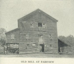
Old Mill At Fairview
No longer in use this building still stands as a reminder of the old milling days in Fairview. When built, nearly a century ago, by Samuel Hutchison, it was a pretentious mill having a long stroke steam engine. In later years it was know as the Griffin mill. Water poser was never used here.
It was soon seen that Fairview possessed such advantages as to make it a good town in which to locate. Jesse C. Weir and James and Martin Rosemond opened stores with sufficient merchandise to supply all the surrounding country. Mechanics of every kind flocked to the place and found plenty of work to keep them busy.
John Duncan was one of the earliest settlers of Fairview. He laid out what was called “Duncan’s Addition,” extending the town westward. Mr. Duncan was an enterprising citizen. He started a carding machine, operating it by horse power on the tramp-wheel principle. This mill, many years later, was struck by lightning and burned. He was a man of education. He built a schoolhouse and taught the children of the settlement for a number of winters.
Soon after an addition was platted by Duncan, Lemon Ryan laid out another. This part of the village was called “Turkeytown.”
Philip Rosemond, John Gibson and John Davenport, as joint proprietors, platted an addition of eleven lots in 1825, and another of nineteen lots, in 1827. The best of these lots sold at sixty-five dollars each.

Fairview Scene 1913
It was believed that Fairview was destined to become a place of great size and importance. When the Wheeling road at that place became the National Road in 1827, the town prospered more than ever. It became a division point for stage traffic and a depot for the entire kingdom of Pennyroyaldom. Here were brought and shipped out to the eastern markets on the big freight wagons traveling the National Road, the products of Pennyroyaldom at that time—tobacco, pork, pennyroyal oil, ginseng, snake-root, sassafras, wormwood—anything that was salable.
Like Beymerstown, afterwards called Washington, Fairview was ambitious to become a county seat. It could not become such of Guernsey county, as that honor had been awarded to Cambridge, and Washington was ever watching for an opportunity to wrest it from her. Then Fairview was too far east to be given consideration. Why not a new county made up of Eastern Guernsey and Western Belmont? Fairview would be about the center and the logical location for the county seat. The county would be called “Cumberland.” This ambition of the early settlers was never realized.
Fairview in 1826.—William Bernard described Fairview as it was in 1826, as follows:
“I came from Frederick county, Maryland, to this place, arriving in September, 1826. If I can live to the 20th day of next September (1881), I will be ninety-one years old. I found a few log houses occupied generally by a laboring class of people. Three of the houses were used as taverns where whisky flowed like water. The names of the proprietors were William Bradshaw at the east end, an Irish-man named Rodgers in the middle, and a man named Hughes at the west end of town. There were two stores, those of James and Martin Rosemond, and Jesse C. Weir.
“There was no church in the limits of the town, but there was a half-finished stone church about a quarter of a mile from town west, belonging to the United Presbyterians, or Unions as they were called. Rev. (Samuel) Findley did the preaching. Methodists were scarce at that time. There were about ten or fifteen who met in a little house that John Duncan built for a school. He taught subscription school in the winter and did carding in the summer. He had a carding-machine run by a horse-power tramp wheel. The women did their own spinning and weaving in those days.
“The only mill we had was a horse mill about a half-mile from town. Just below the mill was a distillery to make it convenient for the people to get their whisky when they went to mill.
“The National Road was graded through the town, but there was no stone yet on it. Saturday was always the business day. The laborers on the National Road and the people from the country would then gather in town and have a jolly time. The merchants were kept busy running up and down cellar stairs, drawing pintfuls of liquors, and occasionally you would see bloody noses and black eyes.
“Politically, Oxford township was Democratic. It was carried for General Jackson and I had the honor of voting for him. We could buy flour at one dollar per hundred. Wheat was worth from thirty-seven and one-half to forty-five cents; corn, twenty cents; and oats, ten cents per bushel.
“There were plenty of hogs in the woods, and if you wanted meat all you had to do was to take a gun and go out and shoot a pig. Mast was plentiful and the hogs were always fat in the fall.”
On February 27, 1846, Fairview was incorporated. Its population was 162 in 1830; 444 in 1850; 365 in 1860; 377 in 1870; 352 in 1880; 322 in 1890; 291 in 1900; 346 in 1910; 231 in 1920; 217 in 1930; and 206 in 1940. David Wherry was probably the first person to locate in the Fairview community.
The Middlebourne Community.—Middlebourne on the National Road, fourteen miles east of Cambridge, was laid out as Middleton by Benjamin Masters on September 1, 1827. Folks persisted in calling the place Middletown which was the name of an older and larger town in Ohio. To avoid confusion the postal authorities named the Guernsey county village Middlebourne when they established a postoffice there. This is the name that it now bears officially, yet to many it is still Middletown.
The fact that the town is approximately midway between Wheeling and Zanesville suggested its name. When Masters found that the National Road would run right through his farm he immediately proceeded to lay out a town, believing that it s location would be conductive to its growth and prosperity. It may not have occurred to him that the place, by the usual route of travel, would be approximately midway between Cambridge and Barnesville; Washington and Fairview; Quaker City and Antrim; and Salesville and Winterset.
Middlebourne Scene 1913
But neither the location nor the name has proved to be much of an asset to the town. Three years after it was founded (1830) it had a population of 126. In 1846 the village was incorporated. By 1850 the population had reached 267. William Hays had opened a tavern of twenty rooms. Here Henry Clay occasionally lodged when traveling form his Kentucky home to Washington. Its barroom, barns for wagoners and lots for drovers’ stock, together with its bountiful meals and hospitality, made it one of the best known hostelries on the National Road. The greater part of this old tavern still stands, known as Locust Lodge. Farther down the street the Penn tavern, built by Peter Corwyn in 1842, is yet in use. The architectural design of its doorway, said to be one of the most unique doorways on the National Road, has attracted many visitors. Greenberry Penn from whom the tavern takes its name was its keeper for many years.
In the early 1850’s Middlebourne flourished. The village boasted of several stores, three or four churches, doctors, a lawyer, a brass band and various mechanics’ shops With the advent of the railroad which passed through six miles south of the town, its glory began to wane. Middlebourne’s population in 1860 had dropped to 178, and by 1870 to 166. Its charter of incorporation was surrendered. Like many other places with promising futures, through which the National Road passed, it is now but one of the old Pike towns.
Benjamin Masters came from Sussex county, New Jersey, to what is now Section 31 of Oxford township, in 1804. Instead of entering land on Zane’s Trace, as most of the pioneers were then doing, he cut a trail through the dense forest to a location three miles north of Zane’s Trace. Here in the northeast corner of his land he built a cabin in which he and his family lived for five years. The Masters moved over to the center of the farm, to a log house that stood on the site of the present Locust Lodge. Soon after his arrival Masters built a horse-mill for grinding corn. He afterwards changed this to a water-mill with one run of buhrs. The bolting cloth was turned by hand like a grindstone while it was fed by a half-bushel measure. Water was brought to the mill through a race a half-mile long.
Masters was a very industrious and enterprising man. He opened a cooper’s shop and made buckets, churns, tubs and barrels from basswood of which there was then much in the surrounding forests. By 1816 he had cleared sixty acres of land. He was married three times and was the father of eighteen children. There were so many youngsters in the household that for convenient identification they were classified as children of the first set, second set and third set, there being approximately six in each set. Benjamin Masters moved to Marion county where he died. Several of his children remained in Guernsey county and reared families here.
With Benjamin Masters came his brother Richard to this section. He settled o the southwest quarter of Section 27 (now the Albaugh farm). Soon after his arrival more settlers came to that neighborhood—McPeeks, Valentines, Smiths, Boyds, Abels and others. In 1818 they organized the Salt Fork Baptist church (still active).
One of Benjamin Masters’ three wives was Hannah McPeek, granddaughter of Patrick McPeek who came from Ireland to Sussex county, New Jersey, before the Revolutionary War. When the war opened he disappeared, probably to enter the service. Believing him dead, his wife married again. Seven years later, like Enoch Arden, Patrick retuned, but unlike Enoch Arden, he claimed his wife. The second husband refused to surrender her. A bargain was made whereby the matter was settled satisfactorily. Patrick, accompanied by one of his two sons, went to South Carolina where he purchased land and became a slaveholder. Hannah was the daughter of Ezekiel McPeek, the son who remained with the mother. Four of her brothers—John, William, Daniel and Richard—came to what is now Guernsey county, probably influenced to do so by the Masters.
The descendants of these four brothers became numerous in the Middlebourne community. Near the Salt Fork church there used to be so many of them that the settlement was called McPeektown.
Bridgewater, of which there is now little more than the name, was platted on the National Road, a half mile east of Middlebourne, by William Orr, March 24, 1834. Orr erected a brick tavern (still standing) which enjoyed a liberal patronage in the old Pike days. At Bridgewater was located one of the four Guernsey county toll gates.
Oxford’s Men and Women.—This township is proud of the records made by many of its citizens in the affairs of county, state and nation. It may have been the inspiration derived from the classical name, on it may have been the influence of Dr. Samuel Findley who established the first church and encouraged education, that prompted them to seek the higher and better things of life. Perhaps it was the type of citizenship displayed by the early settlers who were mostly of good stock.
Nathan B. Scott, born in Oxford township, served as a United States senator from West Virginia for twelve years Joseph D. Taylor represented this district in Congress for nine years, and C. Ellis Moore, a native of Oxford, represented the district in Congress for fourteen years. Addison T. Smith, once a resident of Pennyroyaldom, was a congressman from Idaho for many years.
Mattie McClelland Brown, nationally-known lecturer and temperance worker, was reared in Oxford township. Dr. W. O. Thompson, long-time president of Ohio State University, taught school west of Fairview. David Paul and David Wallace became presidents of Muskingum College.
Oxford has furnished more than thirty men for the various Guernsey county offices. From this township have come two state senators, four representatives to the General Assembly, five common pleas judges, three county auditors, two probate judges, three county recorders, four county treasurers, one clerk of courts, one sheriff, four county commissioners, four prosecuting attorneys and three county surveyors.
How Oxford Was Named.—It is interesting to know the origin of Guernsey county township names. Six of the nineteen were named for presidents—Washington, Adams, Jefferson, Madison, Monroe and Jackson; two for their locations in the county—Westland and Center; one for a family of early settlers—Knox; two from the nature of the land—Valley and Richland; one for a creek—Wills’; and six from places whence some of their early settlers came—Cambridge, Londonderry, Millwood, Oxford, Wheeling and Spencer. The name for Liberty was probably chose arbitrarily.
Five townships were laid off at the first meeting of the county commissioners, April 23, 1810. Present at the meeting were persons from various parts of the county, who were interested in the formations and their names. Amongst these were David Wherry, and Thomas B. Kirkpatrick, one of the associate judges, both of whom lived in the division that became Oxford township. In deference to the wishes of these gentlemen the commissioners requested them to suggest a suitable name. “I came from Oxfordshire, England.” said David Wherry, “and I would like to have it called Oxford, in honor of my old home.” “That suits me,” added Judge Kirkpatrick, “because my ancestors came form Oxford, a little town in Ireland.” Thus it is that Oxford has both an English and an Irish origin.
An Early surveyor.—John Kennon, Jr. is said to have surveyed more land than any other Guernsey county man. Born in Pennsylvania in 1803, he came with his father, John Kennon, Sr., to the southeastern part of what afterwards became Oxford township, in 1806. The Kennon family lived for several months in a rude hut made by standing up four posts, across the tops of which poles were laid and covered with brush. Bark was used for siding the hut. At an opening left for a door a dog was kept at night to protect the family against panthers, wolves and bears. A log cabin twelve feet square was built later. The roof was made of clapboards weighted down by poles. The door swung on wooden hinges.
When other settlers arrived a log schoolhouse, sixteen feet square, was built. Greased paper was used to admit light. The seats were made from split logs hewn smooth. John, Jr. here learned to read, write and cipher. He became interested in mathematics, took up the study of surveying without a teacher, and at the age of sixteen he made his first survey, which was for the noted stone church near Fairview. When the National Road was built through Eastern Ohio, he was engaged as an engineer by several contractors. As land appraiser in 1846, he made what was claimed to be the first true map of Guernsey county.
John Kennon, Jr. lived to be nearly one hundred years old, dying in Fairview where the last years of his life were spent.
Learning a Trade.—In order to learn a trade many a boy in pioneer days bound himself to some craftsman for a period of years, giving labor for the training received. The legally drawn indenture would explicitly set forth the duties of the bound boy to his master, and of the master to the boy. As an illustration of this there follows the indenture of Bethuel Ables who was bound to Daivd Johnson, a blacksmith of Oxford township.
THIS INDENTURE, made this twenty-third day of October, in the year of our Lord one thousand eight hundred and twenty-two, Witnesseth: That Bethuel Ables, of Guernsey county and the State of Ohio, by and with the consent of his parent, John Ables, hath put himself an apprentice to David Johnson, of the county and state aforesaid, to learn the art and mystery of the blacksmith business in all the parts the said Johnson follows, for the term of five years, which term commences on the day and date above written (the said Bethuel being aged sixteen years the 16th instant of October), and ends the twenty-third day of October, Anno Domini one thousand eight hundred and twenty-seven, during which term the said Bethuel Ables the said Johnson shall faithfully serve in all lawful business, according to his power, wit and ability as a dutiful apprentice ought to do.
The said Bethuel is not to follow any kind of gambling, nor waste his master’s goods, his secrets keep, and all lawful commands everywhere readily obey. Said Johnson is to teach and cause to be taught the said Bethuel the art and mystery of the blacksmith business in all the various parts that the said Johnson follows, according to their ability in teaching and being taught, and find the said Bethuel in all wearing clothes, bedding and boarding and washing suitable for an apprentice during said term; also to get him, the said Bethuel, one coat, vest-coat and pantaloon of factory cotton when he arrives at the age of eighteen, and at the expiration of said term, said Bethuel is to have one bellows, one anvil and one vise, and the liberty of the shop to make such small tools as are necessary to start a shop with; also during said term the Johnson is to give the said Bethuel six months’ schooling.
For the true and faithful fulfillment of the above engagements we have each of us set our hands and seals the day and date above written.
Attest: David Johnson,
Abraham Anderson Bethuel Ables
James Starr John Ables
Owners of Real Estate in 1840.—Following is a complete list of the real estate owners in Oxford township a century ago (1840). The number of acres in each farm and the section in which it was located are given. In most cases the owners were heads of families living in the township.
Ables, Bethuel, 50 acres, sec. 21 and 31; Aududle, Charles, 77 acres, sec. 9; Armstrong, William, 158 acres, sec. 14; Aududle, Thomas, 76 acres, sec. 9; Arnold, Fanny, 79 acres, sec. 3; Arnold, William, 158 acres, sec. 3; Atherington, Benjamin, 50 acres, sec. 12; Aududle, Alexander, 80 acres, sec. 19; Ashbaugh, Frederick, 1 acre, sec. 2; Beatty, Washington, 1 acre, sec. 31; Bennett, John, 182 acres, sec. 23; Bay, Andrew, 146 acres, sec. 35; Bay, William, 226 acres, sec. 35; Brown, Joseph, 195 acres, sec. 17; Baker, Robinson, 621 acres, sec. 1, 7 and 12; Barkey, Jacob, 160 acres, sec. 26; Brown, Bernard, 160 acres, sec. 31; Blackiston, William, 35 acres, sec. 31; Borton, William, 79 acres, sec. 19; Borton, Reuben, 123 acres, sec. 7; Borton, James, 159 acres, sec. 13; Bevard, William, 146 acres, sec. 30; Blazier, Peter, 44 acres, sec. 31; Boyd, George, 100 acres, sec. 32; Barkhurst, William, 163 acres, sec. 9; Bell, John, 86 acres, sec. 7 and 12; Bouler, James, 265 acres, sec. 9; Bulger, Reuben, 1 acre, sec. 2.
Cochran, William, 322 acres, sec. 30; Carter, Philip, 79 acres, sec. 15; Carrothers, James, 38 acres, sec. 11; Cranston, John, 151 acres, sec. 5 and 11; Cranston, Archibald, 80 acres, sec. 5; Cranston, James, 82 acres, sec. 11; Cranston, Thomas, 160 acres, sec. 5; Cranston, William, 82 acres, sec. 11; Creighton,Christopher, 165 acres, sec. 8; Coffield, James, 78 acres, sec. 25; Cope, Samuel, 49 acres, sec. 26; Chambers, John, 1 acre, sec. 2; Corwyn, Peter, 74 acres, sec. 31; Duncan, John, 40 acres, sec. 2; Dillon, James (Heirs), 160 acres, sec. 18; Dillon, William, 96 acres, sec. 18; Dillon, Christopher, 158 acres, sec. 3.
Forrest, James, 1 acre, sec. 27; Flegor, Jacob, 114 acres, sec. 2 and 5; Forbes, Boyd, 138 acres, sec. 25; Ferrell, William (Heirs), 195 acres, sec. 13 and 14; Ferguson, Samuel (Heirs), 149 acres, sec. 13; Ferguson, Thomas, 145 acres, sec. 6; Gregg, Burr, 13 acres, sec. 31; Gardner, James, 100 acres, sec. 21; Giffee, Josiah, 13 acres, sec. 1; Glazener, James, 155 acres, sec. 25; Gardner, William, 159 acres, sec. 15; Graham, William, 7 acres, sec. 5; Gracy, Jackson, 240 acres, sec. 14; Giffee, Benjamin (Heirs0, 160 acres, sec. 1; Gatchell, Jacob, 160 acres, sec. 1; Garrett, James, 100 acres, sec. 29; Gill, Mordecai, 144 acres, sec. 32; Gleaves, Samuel, 6 acres, sec. 2; Grier, Thomas, 120 acres, sec. 14 and 20; Grimes, William, 167 acres, sec. 8 and9; Grimes, James, 80 acres, sec. 9; Gibson, Hugh, 77 acres, sec. 9; Grier, Isaac, 168 acres, sec. 6; Gracy, Richard, 80 acres, sec. 15.
Hopkins, Jared, 133 acres, sec. 23 and 24; Henderson, William, Jr., 131 acres, sec. 23; Henderson, William, Sr., 403 acres, sec. 17 and 23; Hutchison, John C., 1 acre, sec. 2; Hays, Thomas, 273 acres, sec. 25 and 31; Hall, Robert, 160 acres, sec. 2; Henderson, John C., 87 acres, sec. 11; Henderson John, 114 acres, sec. 29; Hall, George, 25 acres, sec. 8; Hall, James, 52 acres, sec. 8; Henderson, James, 80 acres, sec. 17; Henderson, John (Heirs), 80 acres, sec. 29; Henry Peter, 50 acres, sec. 32; Hamilton, John, 72 acres, sec. 11 and 17; Hilton, Morris, 99 acres, sec. 32; Henry, Stewart, 50 acres, sec. 25; Head, James, 79 acres, sec. 19; Henderson, Robert, 116 acres, sec. 29; Inglish, Richard, 5 acres, sec. 2; Jackson, Benjamin, 33 acres, sec. 8; Johnson, John B., 33 acres, sec. 26; Kirkpatrick, Richard, 62 acres, sec. 12; Kennon, John, 21 acres, sec. 1; Kennon, James, 81 acres, sec. 5; Kirkpatrick, Thomas, 119 acres, sec. 12; Lowe, Henry, 61 acres, sec. 3 and 17.
Moore, John, 230 acres, sec. 18 and 29; McClenehan, John, 160 acres, sec. 21; Moore, William, 200 acres, sec. 20 and 21; Moore, Edward, 151 acres, sec. 33; Merryman, James, 82 acres, sec. 8; Morton, Moses, 339 acres, sec. 11, 12 and 13; Morton, Edward (Heirs0, 114 acres, sec. 1; Marlowe, Samuel, 135 acres, sec. 13; McKee, Thomas, 112 acres, sec. 30; McPeek, Daniel, 160 acres, sec. 27; McPeek, John, 152 acres, sec. 33; Montgomery, James, 2 acres, sec. 26; McConnell, Thomas, 119 acres, sec. 20; Masters, Richard and William, 295 acres, sec. 26 and 32; McWilliams, Samuel, 117 acres, sec. 25; McCrea, David, 91 acres, sec. 31; Masters, Daniel, 30 acres, sec. 27; McCartney, John, 20 acres, sec. 2.
Nace, Samuel, 4 acres, sec. 2; Osborn, William, 26 acres, sec. 27; Odell, Stephen, 120 acres, sec. 2 and 119; Osborn, Covey, 15 acres, sec. 26; Orr, William, 151 acres, sec. 33; Patterson, William, 108 acres, sec. 3; Parry, Gibbons, 1 acre, sec. 2; Pumphrey, Beale, 1 acre, sec. 2; Paul, Andrew, 186 acres, sec. 8; Peck, James, 25 acres, sec. 2; Pollock, Thomas, 40 acres, sec. 2; Parks, Hugh, 96 acres, sec. 2; Rose, Washington, 30 acres, sec. 23; Roseman, Martin, 66 acres, sec. 2; Ryan, Lemon, 10 acres, sec. 2; Roseman, James, 44 acres, sec. 2; Rose, Thompson, 81 acres, sec. 35; Riggle, Isaac, 155 acres, sec. 7; Rowles, Nicholas, 19 acres, sec. 31; Reese, Armine, 51 acres, sec. 33.
Stewart, James, 1 acre, sec. 12; Scott, Richard, 100 acres, sec. 29; Stewart, William, 169 acres, sec. 29; Sours, Charles, 106 acres, sec. 19 and 24; Stevens, Joshua, 295 acres, sec. 26; Stewart, John (Heirs), 132 acres, sec. 27; Smith, David, 149 acres, sec. 32; Saltsgaver, Jacob, 3 acres, sec. 2; Stevens, Joshua, 76 acres, sec. 9; Scott, James, 559 acres, sec. 36; Shipley, Talbert, 79 acres, sec. 3; Tracy, William W., 80 acres, sec. 27; Thompson, Andrew, 50 acres, sec. 21; Theaker, John, 100 acres, sec. 33; Turkle, Joseph, 159 acres, sec. 15; Turkle, John, 159 acres, sec. 15; Tracy, Sheridan, 109 acres, sec. 20; Thompson, Robert, 50 acres, sec. 2; Tillett, James, 6 acres, sec. 2; Taylor, Alexander D., 180 acres, sec. 20 and 21.
Valentine, Samuel, 85 acres, sec. 31; Valentine, Jeremiah, 80 acres, sec. 21; Vanmeter, Morgan, 2 acres, sec. 2; Vanevey, Mary, 64 acres, sec. 26; Wallace, Thomas, 86 acres, sec. 27; Weir, Jesse, 24 acres, sec. 2; Woodburn, Alexander, 75 acres, sec. 25; Wherry, Joseph, 160 acres, sec. 18; Wallace, David, 100 acres, sec. 6; Wilson, John, 104 acres, sec. 11; Wine, Christian, 8 acres, sec. 2; Wherry, David, 59 acres, sec. 18; Wherry, James, 226 acres, sec. 24; Wherry, John, 80 acres, sec. 24; Wallace, John, 389 acres, sec. 1 and 6.
Owners of lots in Fairview were the following; Frederick Asbaugh, Reuben Bulger, Henry Barnes, William Bratton, William Barkhurst, John Bell, James Carter, David Coultrap, Matthias Clutter, William Cummins, Joseph Carlisle, Amos Duhammel, John Duncan, Jacob Flegor, Joseph P. Gazzam, Isaac Gleaves, Benjamin Giffee, Samuel Gleaves, John Gamble, William Hall, Joseph Hare, Joseph Inskeep, Newell Kennon, William Lane, John Millson, Edward Morton, William Neil, Hugh Parks, Isaac Pumphrey, George Plattenburg, Horace Pumphrey, Absalom Pumphrey, J. M. Pumphrey, Beale Pumphrey, Gibbons Parry, John Peck, James Peck, Lemon Ryan, Philip Roseman, Mary Roseman, James Roseman, Morton Roseman, Thomas Stanberry, William Tipton, William Tracey, Jesse C. Wier.
The following owned the lots of Middlebourne: John Ables, William Armstrong, William Bay, Ebenezer Blackiston, Bernard Brown, William Bevard, Jared Clary, William G. Cook, William Cochran, Peter Corwyn, Mary Dickerson, Isaac Ellsworth, James Fotheringham, Barr Gregg, Jacob Glazener, John Gibson, Thomas Hays, William Hays, Stewart Knight, William R. Haines, Mely Jarvis, John Hall, Alexander Kirkpatrick, James Luch, Benjamin Masters, Joseph Morrison, William Morrison, Corwyn McAllister, Jonathan Miller, Greenberry Penn, Thomas Plant, Josephus Pugh, David F. Robe, William Richard, James Richardson, Nathaniel Smith, Garrett Smith, David Scott, John Stiles, Joseph Stotts, Samuel Thompson, John Valentine, Samuel Valentine, Jonathan Warne, John Wallace.
Owners of the lots in Bridgewater were James Burdett, William P. Blackiston, William Cowden, John Ducher, John Gilpen, Thomas Hays, William Hays, Wilmuth Jones, John Hall, Samuel McPeek, Elizabeth Valentine.
The Pennyroyal Reunion
First Held in 1880.—Oxford township’s most noted institution is the Pennyroyal Reunion. Each year since the first reunion was held in 1880, residents of Oxford and adjoining townships, many living elsewhere but who had once lived there, and still others from far and near, attracted by the programs, the crowds, or the unique character of the event, have come together to enjoy it. It is one of the oldest and best known gatherings of its kind in the state.
Oxford township was laid out in 1810 as one of the five townships into which the county was originally divided. It was one of the first townships to be settled, some of the pioneers being the Ables, the Bortons, the Wherrys, the Rosemonds, the Dillons, the Mortons and the Kennons. From the wild pennyroyal, which grew in abundance, an oil was distilled and sold in eastern markets. On account of this unusual industry the section was often referred to as the pennyroyal district.
It was proposed that in August, 1880, a reunion of persons living in the pennyroyal territory, together with those who had been born there and living elsewhere, be held in Gardiner’s grove. The event, which lasted two days, proved to be a great success. There were living at that time several persons who were amongst the pioneers of the township, and they related some of its early history. The program, which consisted of addresses, reminiscences and music, was interesting and instructive to both old and young. It was decided to make it an annual affair.
Memorial Services Are Held.—In 1929, the fiftieth reunion was held and the occasion was made one of special interest. Those who took active parts at the first meetings have mostly passed on, but their children and their grandchildren come together each year to renew friendships and pay tribute to the ones gone before. At each reunion the names of all persons connected with Pennyroyaldom, who died the preceding year, are read, and a fitting memorial service is held.
Attended by Many Eminent Men.—The Pennyroyal Reunion has attracted state-wide attention. Many have come from distant states to be present on these occasions. Speakers of national reputation have appeared on the programs. It is recalled that in 1895, the three candidates for governor—Asa S. Bushnell, James E. Campbell and Jacob S. Coxey—spoke there the same day from one platform. Men who afterwards became Presidents of the United States, Senators, Representatives, and persons eminent in various activities, have been present at these reunions.
Interest Is Strong.—While interest in the reunions on the part of those closely associated with Pennyroyaldom has in no way declined, the crowds attending them are not as large as they were a generation ago. This may be accounted for in part by the fact that there are more attractions of a similar character throughout the country. At one time the Pennyroyal Reunion was the only gathering of its kind in this part of the state and it held the undivided interest of the people, but now there are many reunions of folks bound together for one reason or another. Notwithstanding this one difference of attendance, the programs are just as strong as those of former days, and for years to come the Penyroyalists will no doubt continue to meet together annually for enjoyment and to keep sacred the memory of their forefathers.
The Pennyroyal Song.—At one of the early Reunions the Pennyroyal Choir was organized, composed of a number of the best singers of Pennyroyaldom. Each year since the organization the singing of the choir has been a feature of the gathering. The personnel has changed through time until today many members of the choir are grandchildren of the original members. Prof. John H. Sarchet was leader of the choir for more than forty years. He composed the Pennyroyal Song which is sung by the choir each year.
Some of its stanzas follow:
The Briton sings “God Save the King”
The Irishman of Shamrock green,
But there’s a land they’ve never seen
In O-hi-o.
Her Hills and Valleys laugh and sing
While flocks and herds their tribute bring,
And pennyroyal is “on the wing”
In O-hi-o.
CHORUS
Then a song of pennyroyal,
And her sons and daughters loyal,
Sturdy tillers of the soil
Down in O-hi-o.
We love the scented clover
That paints her meadows over,
And the pennyroyal odor
Down in O-hi-o
‘Tis found not in the Railroad Guide,
Nor on the map in stately pride,
But mem’ry bounds her borders wide
In O-hi-o.
Her currency is “honest toil”
For every boy and every girl,
Her emblem, fragrant pennyroyal
In O-hi-o.
No standing army keeps her peace,
No need of judges or police,
No pestilence nor fell disease
In O-hi-o.
Then let us join the festive song,
And swell the chorus loud and strong,
Say to the world that we belong
In O-hi-o
And as we gather once a year
We’ll stories tell to memory dear,
Our fathers and their God revere
In O-hi-o
Heroism of a Pioneer Woman
Among the pioneers of Oxford township were William Henderson and his wife, Nancy Clendennon Henderson, the former having been born in 1774, and the latter in 1780. They were married in Pennsylvania in 1797, and came to Guernsey county in 1806, with their four small children.
The Home on Zane’s Trace.—Like the most of the other early settlers of this section they came by way of Zane’s Trace, and like the others, too, they sought a place for a home near the only thoroughfare through the county at that time. The spot selected was in the valley of Salt Fork creek, where Zane’s Trace made an abrupt turn to the west. A large tract of land was entered, a primeval forest at that time; and, as it lay in the seventh of the Seven Ranges, was paid for at the government land office in Steubenville. This public land sold at $2.00 an acre, if easily accessible to the outside world; at $1.50 an acre, if located otherwise.
The farm upon which William and Nancy Clendennon Henderson settled is now known as the Levi Carter farm. Their log house stood near the spring where the road forks, one branch leading to Fairview, the other paralleling the creek. Back of the cabin to the northwest as a hill, then covered with forest trees, but later cleared and planted as an orchard. Within the orchard two of their children, who died a few years after they settled there, were buried.
Their settlement in Guernsey county was much like that of many other pioneers Excepting for the following incident there would be no story to tell, other than one similar to that which might be told about any family that came into Guernsey county in those early days.
A Terrified Mother.—One day, a short time after they had established their home in Oxford township, William Henderson went away, leaving his wife and the small children alone in the cabin. It was not considered unsafe for them to be left in this way, as they had never been molested either by man or wild beasts.
As the children played about the house Nancy Clendennon Henderson was engaged in baking bread in one of the old-time ovens. Happening to look out the open door, she was terrified on seeing a band of Indians on the hill northwest of the house. It was obvious that their attention was directed to the cabin. They were in council and seemed to be somewhat excited.
What should she do? It was a long distance to a white settlement or the nearest neighbor. Escape with the children was impossible. To attempt a defense would be useless. One of the Indians left the others and started towards the house. As he approached the open door her mind worked quickly, and it was probably her wit that saved her and the children.
Saved by Bread.—She rushed to the oven and threw open the door. To her relief she saw that the bread was done. Gathering the loaves in her apron she returned to the open door just as the Indian reached it. Standing there facing him, as one without fear but with a wish to do him a kindness, with both hands holding her apron heaped high with the brown loaves of hot bread, she indicated that it was a gift for the Indians.
At the unexpected action of the woman, the Indian stepped back surprised, but after a moment’s hesitation he came forward, took the bread, saying “Good Squaw,” then started back to the others who were advancing towards the house. He divided the bread amongst them, and after a further council, they all passed over the hill in an opposite direction.
Courage Rewarded.—A few mornings after this Mrs. Henderson and the children were again by themselves. glancing towards the hill ever in her mind as the place from which danger might come, she saw a lone Indian moving towards the house, carrying something on his back. She recognized him as the one to whom she had given the bread. His burden was a dressed deer which he laid at her feet. This was to reward her for her courage and kindness. She was made to understand from what the Indian tried to tell her that the giving of the bread a few days before had saved her own life and the lives of her children. They had been hunting but could find no game. They were almost famished and in such a mood as to be prompted to commit any deed that might suggest itself.
A Typical Pioneer Woman.—Nancy Clendennon Henderson was a typical pioneer woman of Guernsey county. Before coming to Oxford township she had been educated in the schools of Harrisburg, Pennsylvania. She was especially anxious that her children receive an education, but here were neither schoolhouses nor teachers in this new country. It was through her influence that logs were hewed and a school erected near their home. She became the first teacher and her own children were some of the pupils.
The old log schoolhouse in which she taught, the first in that part of the county, was destroyed long ago. Others, in succession, have been built in its place.
Many descendants of William and Nancy Clendennon Henderson are now living in Guernsey county. The original pioneers are buried in a cemetery on Pultney Ridge in Millwood township, that is generally known as “God’s Knob.”
The Old Bradshaw Tavern
Tavern Described.—In the palmy days of the old National Road one of the most famed hostelries in Eastern Ohio was the Bradshaw tavern in Fairview. It was situated in the east end of the town, fronting the pike on the north and the Barnesville road on the west. After the tavern was torn away, the location became the site of the Sheppard home.
This old tavern really antedated the National Road which was built in 1827. Before that time the main part of the old hostelry stood one-half mile away on Zane’s Trace, or the old Wheeling road, at the point where that thoroughfare turned to the south. It was removed to its new site on huge rollers.
The tavern was built in the shape of an “L,” a popular architectural design of its day. It was two stories in height and painted white. There were large front and rear porches struck full of small windows set off with green blinds. Perched upon the apex of the roof was a large bell, and borne aloft on a pole in front was a sign-board bearing the inscription,
FAIRVIEW HOUSE
W. Bradshaw
Major William Bradshaw was the proprietor of the tavern for more than forty years. It was he who was the landlord when it was a stopping place for travelers on Zane’s Trace, and it was he who moved it to its location in Fairview, enlarged it, and made it famous to all who traveled the National Road.
Bradshaw the Proprietor.—He was Irish, yet he always told with pride that he was born on the ocean while his parents were enroute to America, and was therefore no child of St. Patrick. His military title was acquired in the state militia service. He was more than six feet in height, straight as an Indian, and his step was of military regularity. His ruddy face and white hair and beard gave him an attractive appearance.
The tavern marked a division end on the National Road. Stage teams were changed here, and passengers were often fed and domiciled for the night.
The tavern was not only noted for the meals it served, its comfortable rooms and beds, and the barroom with the big fireplace, but also for its genial landlord. Major Bradshaw possessed a strong natural sense of dignity and, although he accommodated himself to all the various grades of society when occasion demanded, he never permitted the reputation of his house to suffer. He was a zealous Whig n politics, but later became a radical proslavery man. He was a keen judge of human nature, and, by employing his Irish wit, he was able to meet satisfactorily almost every type of persons stopping at the tavern. His death occurred in Barnesville about the time of the Civil War.
Henry Clay a Guest.—Henry Clay was often a guest at the Bradshaw tavern. This famous statesman is said to have stopped at other places in Guernsey county—at Cambridge and at Middletown. He was a member of Congress for many years, sponsored the building of the National Road, and invariably traveled it in going back and forth between his home and Washington. On account of the comparatively slow mode of travel, he was required to stop many places for meals and lodging.
Fifty years ago an old citizen of Fairview said he remembered seeing Clay at the tavern back in the early days of the pike, shaking hands with people on the old porch and in the barroom. He recalled the old orator as being tall and straight of form, with chestnut hair. He wore a sallowtail coat. With a broad smile he would alight form his coach and begin his round of handshaking, in which not a man or boy would be missed.
Peter Simpson, the Hostler.—Opposite the tavern were the coach-yard, stables and sheds. Like the garage at the modern hotel, they served as storage for the traveler’s equipment. Here, too, the stock that was being driven through was fed and turned in for the night. Over this annex to the Bradshaw tavern old Peter Simpson, colored hostler, held sway for many years. He was happiest when all the space in the coach yard was taken and the barroom filled with jolly travelers. His heart was almost broken when the railroad came, causing the long-distance travel on the pike to pass away. “Bunk” and “Saun” were two dogs of the place, but little less known than Bradshaw and Simpson themselves.
Many tales were told by the travelers as they sat about the big fireplace of the Bradshaw tavern, and many incidents are related about the place itself. There was, perhaps, no other hostelry between Wheeling and Zanesville, that enjoyed a fairer name, or whose landlord was more widely celebrated for hospitality, eccentricity, and keen satire, than was the tavern of Major Bradshaw.
Old Stone Church
Built in 1820.—About 1820 a little company of pioneers who had been taught to worship in accordance with the doctrine of the Associate Reformed church, erected a meeting-house in a grove on the top of a hill south of Fairview. They built it of stone, although their homes and all other buildings in that section at that time were made of logs. They were poor and unused to the luxuries of life. However, a house erected to God, they believed, should be better than their own.
Dr. Finley, the First Pastor.—Two years before this Dr. Samuel Findley had come into the community and organized a church society. Lacking a house of worship, the people assembled beneath the trees on the hill once a month, where Dr. Findley preached to them. After the stone church had been built, he gave one Sunday of service there, one at Antrim and two at Washington, each month. During the week days he conducted an academy at West Alexander, Pennsylvania. This arrangement necessitated much travel by horseback, over roads that were almost impassable at certain seasons of the year. Sometimes he would miss a Sunday and the church would be without preaching for eight or nine weeks at a time.
When Dr. Finley preached, the stone church was usually full of worshipers. According to his custom he would read and explain a psalm, following which he would preach two heavy sermons with a brief interval between. This period would be devoted to catechizing the children.
The greatest event of the year was the Lord’s Supper which commenced with a fast day on Friday. So devout and faithful were the worshipers at the stone church, that on this day they abstained from food and rested from all labors, as if it were the Sabbath. The meetings were continued through Saturday, the Sabbath and Monday. The services were long and the sermons appealing and eloquent.
Slabs for Seats.—The pulpit, built high up on the wall, was elaborately constructed. Families sat together, each having its own pew. These occupied about half the church. The other half was seated with slabs laid across massive logs.
Religion to those people was a serious matter. That they might lack suitable Sunday clothes was of no consequence. They came to church in homespun; in summer, the men and boys without coats. Children came barefoot, and so did the young ladies thus come to the neighborhood of the church, and then, seated on a log in a retired spot, would put on their shoes.
Dr. Finley resigned as pastor of the stone church in 1831 to become a full-time preacher at Antrim. Following Dr. Findley were Rev. Alexander Miller and Rev. John Anderson, both Scotchmen and preachers of great ability and learning.
Rev. Hugh L. Forsythe, the Next Pastor.—Then came Rev. Hugh L. Forsythe to the stone church, whose whole time was given to the Fairview congregation. The old stone church was too small for the many who wished to attend and a larger frame house was erected west of the village. Rev. Forsythe was pastor for nineteen years—from 1842 to 1861.
This story of the stone church is written, not only to show what a pioneer place of worship was like, but to call attention to a church whose influence reached into all parts of Guernsey county and many other places; to a church that had a large part in the county’s development.
The Associate Reformed church afterwards became the United Presbyterian church. This was the first Associate Reformed church in Guernsey county; all the others of that denomination in the county could trace their origin back to the stone church, directly or indirectly.
The Mother of Ministers.—No other church of any denomination in Guernsey county has furnished more prominent ministers than the stone church at Fairview. The list includes such men as Robert Stewart, Alexander Patterson, James McCrea, David Paul, William Johnston, Uray McClenahan, W. T. Campbell, Stewart McClenahan, H. F. Wallace, J. M. Hamilton, J. B. Gowdy, D. A. McClenahan and David A. Wallace. Some of these were amongst the greatest preachers in the United Presbyterian church; some were professors in theological seminaries; and David Paul and David A. Wallace became presidents of Muskingum College.
Much of the success of this remarkable church may be attributed to the efforts of two men—Dr. Samuel Findley Founded the church and remained there until it was thoroughly established in the community. Rev. Forsythe, during this long and faithful service, inspired many of those who became prominent as preacher.
~~~~~~~~~~~~~~~~~~~~~~~~~~~~~~~~~~
Stories of Guernsey County by Wm. Wolfe Pages 965-984
CHAPTER XXXIII
Richland Township
RICHLAND township was organized on July 28, 1810, at the house of Samuel Leath. The twenty-eight and one-half square miles of territory within its boundaries were a part of the military district, excepting three square miles in the southwestern part, which were included in the Congress lands.
Seneca Fork of Wills creek cuts across the southern side of the township, and Leatherwood creek, the northern. Between the two streams are fertile ridges that may have suggested the name for this political subdivision of Guernsey county.
Early Settlers.—One of the earliest, if not the earliest settler in the township, was John Laughlin, Sr., who came there in 1808 from Pennsylvania. Samuel M. Dilley, born in New Jersey, came with his brother to what is now Senecaville, in 1816. Joseph Finley, born in 1789, came from Pennsylvania in 1810. James Finley came from Pennsylvania in 1814. William Thompson settled on Seneca creek at an early date, as did David Satterthwaite.
Old Folks of 1876.—The following list of persons more than seventy-six years of age, living in Richland township in 1876, includes many of the pioneers: Elizabeth Alexander, Nancy Arndt, Mrs. Bennett, James Buchanan, Mary Baldridge, James R. Boyd, Lucretia Buchanan, Lydia Clark, Robert Dilley, John Dollison, Lucinda Dollison, Scott Emerson, Mary A. Foraker, John Frame, George Gooderl, Mrs. George Gooderl, Mrs. F. Gooden, Samuel Gibson, Tamar Gooden, Mary Halley, Mrs. Hull, James Hartup, Thomas Hunt, Ebenezer Harper, Tressie Jones, Mary Jackson, William G. Keil, Mrs. Samuel Lent, Henry Ledman, Mrs. A. Laughlin, Laban LaRue, Samuel Lent, Margaret Lowery, Catherine Ledman, John Laughlin, Lydia Lowery, Margaret LaRue, Mary Morrison, Eleanor Medley, Almira McCleary, James Miller, John Mosier, Elizabeth Oliver, Mrs. Payne, John Potts, William Potts, Henry Popham, Mrs. Stiers, Mrs. John Squibb, Jacob Sharer, Susan Shroyer, John Squibb, James Stranathan, Raphael Stiers, Jeremiah Sargent, Ann Thomas, Benjamin Winnett, John Winnett.
Population.—In 1820 Richland township had a population of 860; 1830, 1,704; 1840, 1, 772; 1850, 1,438; 1860, 2,171; 1870, 1,404; 1880, 1,439; 1890, 1,471; 1900, 1,499; 1910, 2,110; 1920, 2,322; 1930, 2,056.
Oil and Coal.—As related in another chapter of this volume, it was in Richland township that oil was first found in Guernsey county. Floating on the creek was an oily substance which the pioneers gathered by wringing it from blankets that has been spread on the surface of the water. It was used for medicinal purposes. As it resembled an oil discovered in New York by the Seneca Indians, it was called Seneca oil. The name was given the steam on which it was found, also the town later built near the stream. Like the Seneca oil of New York this oil was found to be common petroleum.
What is known as the Cambridge vein of coal underlies the western half of the township. As this vein dips towards the southeast, mining here is carried on at greater depths than in other parts of the coal field. The leading mines of the township are, or have been, Rigby and Walhonding No. 3, near Senecaville, and Black Top and Goodyear, near Lore City.
The Pinnacle.—Between Salem and Concord churches is one of the highest hills in the county, known as the Pinnacle. Here lived an Indian family for several years after the white settlers came into that section. They had a cabin home and lived mainly by hunting and selling baskets which they wove. The family name was “Indian,” and two of the boys were “Jim Indian” and “John Indian.”
Richland’s War Record.—For several years Ephriam Dilley and Jones McCann, Revolutionary soldiers, lived in Senecaville and drew pensions. Abram Dilley, George Gooderl, James Buchanan, Andrew Morrison, George Morrison and Robinson Rose were soldiers of the War of 1812. The last survivor of these was James Buchanan who died in 1880. Four Senecaville men left for the Mexican War; Jackson McDaniel, John Boyd, Joseph Lorimer and Moses Thompson. McDaniel and Thompson never returned.
The first nine persons from the from the township to enlist in the Civil War were the following; Alexander W. Leeper, Henry Breidenthal, Clinton C. Buchanan, Joseph D. Finley, Thomas C. Glasner, Adam LePage, Alexander Moorhead, A. Shipley and Justice C. Taylor. Although most of them were on the firing line in several important battles, none were killed or wounded.
Fourteen families of Richland township furnished three soldiers each for the war, an unusual record for a community with such a small population. Of the forty-two from these families some retuned maimed for life; one starved to death in Andersonville Prison; one was killed in the Battle of the Wilderness, and another in front of Atlanta.
A Town That Never Grew.—We are apt to think of towns as being permanent like the hills, enduring throughout the ages. History shows us that, like men, towns are mortal, and like men, too, their very names may be forgotten. In the Bible are names of towns, even cities, that have perished; the locations of some of these are unknown today. Lost cities have been excavated by archaeologists and found to have been built on sites of other cities lying beneath them. Just as men die from various diseases, so form various causes do towns cease to exist.
Since Guernsey county was formed many towns platted within its boundaries have passed away. Some of them sprang up under the most favorable auspices, passed through a period of growth and prosperity, reached the acme of their greatness, then gradually declined and vanished. In some instances not only the locations but even the names of these towns are not generally known.
Within twenty or thirty years after the organization of the county towns had been started in every part of it. There was a mania for town building. Not fewer than thirty towns were laid out, some of them in the midst of the forest. Lots were set aside for court houses and jails. These were the bait for the county seat. Many of these towns proved to be disappointments.
Union was once a town in Guernsey county, located in what is now northern Richland township, a short distance southwest of Lore City. It was platted by Elijah Lowery and John Laughlin, in 1812. These founders evidently had visions of an important municipality, and planned accordingly. Streets sixty-six feet wide were laid out parallel to each other—Main street, Green street, Water street, South street, Market street, Second street, and North street. Alleys bore such names as White alley, Black Oak alley, Dry alley, Sweet alley, Clover alley and Flat alley. Lots No. 1 and No. 2 were reserved for a court house and jail; and No. 50 and No. 51, for a church and graveyard.
When Union was platted Guernsey county was two years old. The county then contained much territory that is now a part of Noble county. Union was very near the geographical center of Guernsey county. There was much dissatisfaction because Cambridge had been chosen as the county seat. It is reasonable to believe that Lowery and Laughlin hoped to have the seat of county government changed to their town. This did not happen and Union eventually passed away.
Senecaville.—David Satterthwaite platted a town which he named Senecaville, on July 18, 1815. Seventy years later Robert Thompson, a citizen of that community, who had moved there with his father the year after the town was platted, related the following:
“The streets were lined with stumps and brush. There was a salt spring on the edge of the creek near the Greenwood bridge, from the water of which salt was made at a furnace containing about thirty-six kettles. It does not seem that at that time there was any other salt furnace on this side of the Ohio River. People came from distant points and conveyed it away. It sold at from $2.50 to $3.00 per bushel. These works consumed a considerable quantity of wood, and furnished employment to many choppers, salt-boilers and others, wand were the principal, if not the only, manufacturing feature of the village.
“Many rough characters were in the community then, and election day was a favorite time to settle grudges and animosities. The couple bent on punishing one another would get toned up by drinking whisky, choose seconds, throw off their outer clothing, and go into the conflict. The battle was ended when one of the men cried enough’, or, if he was not able to do so, when his second did; then the foes, having had satisfaction, took a drink together, and got down to chat.
‘When a farmer sold his stock he had to deliver it, the nearest points being Barnesville and Washington, and to those places one had to go for farm implements and some articles of household use. I once took a horse to Barnesville and slid a plow home, the point being covered with a wooden shield.
“Coffee then was fifty cents a pound, but it was only used when the preacher called and on other notable occasions. A pound might last six months. Pork was worth $1.25 to $1.50 a hundred, and calico was twenty-five to thirty-seven and one-half cents per yard.”
The First School.—William Thompson, an uncle of Robert Thompson, opened the first store in Senecaville; it stood on the lot where the Methodist church now stands. To purchase dry goods and groceries for his store he rode horseback to Philadelphia. The carriage on the goods purchased was $11.00 per hundred.
Children of the wood-choppers, salt-boilers, farmers and other citizens of the community lacked educational advantages, as this was in the days before public schools had been established. There was nobody to teach the children, neither did many of the parents have money to pay for such service had a teacher been available. While in Philadelphia purchasing goods for this store, William Thompson employed Isaac Woodard, a lame schoolmaster, to come to Senecaville to teach for twelve months. Thompson and his brother agreed to pay him for his services. All the parents of the community were told to send their children to the school and it would not cost them a cent. Joseph and Abram Dilley, unwilling that two men should pay for the education of all the children, many of whom were their own, assisted financially in maintaining the school. This was probably the first free school in Guernsey county.
Early Days in Senecaville.—For several years Senecaville consisted of a few log cabins situated mostly on the east side of Main street. We here relate some facts and traditional incidents of the early days, that may be of interest to those who now know the town.
Henry Popham made boots and was framed for his skill as a cobbler. Being an admirer of President Andrew Jackson, he made and sent a pair of “fine boots” to him as a present. They were of the long sharp-toe style, fashionable in that day. It was the custom of the old veteran not to accept gifts from anybody. However, he must have liked the boots, for he kept them, sending Popham a sum of money that he believed them to be worth.
Abram Dilley and Benjamin Rogers operated blacksmith shops, and a Mr. Reed, a wagon shop. Dr. Baldridge owned a carding machine which was patronized by people who came from many miles around. Enoch Millhone had a mill which could be operated in wet weather only, when there was a sufficient flow of water. In dry weather the milling was done at an old horse mill owned by John Potts.
The last circular wolf hunt in the Senecaville community was held west of town, between Senecaville and Byesville. At this hunt was seen the last wild turkey in that section. Isaac Warden and Andy Hawkins were the last remnants of the sturdy backwoodsman, and long after others had laid aside their pioneer garbs they continued to wear their hunting suits and moccasins.
John Fordyce engaged extensively in buying and packing tobacco which was one of the leading products of the farms in those days. The first two or three crops on the newly cleared ground were tobacco; then came some corn, wheat and grass. It is said that Fordyce bought and packed as many as a thousand hogsheads of tobacco a year, which were hauled by teams to Baltimore.
In 1832 the first circus came to Senecaville. It was a wagon show. An elephant, a kangaroo and a Shetland pony constituted the menagerie and attracted much attention.
Newspapers were scarce. They were either read aloud to groups of people who assembled at the stores, or were passed around amongst the reading population. For many years the only papers reaching Senecaville were the St. Clairsville Gazette, the Zanesville Aurora and the Guernsey Times.
An epidemic of cholera in 1833 and one of small pox in 1853 caused much consternation. The effects were mostly fatal, as modern means of treating these diseases were then unknown. Edward Ward is said to have been the first white child born in Richland township.
Rev. William G. Keil.—For long time service as a Guernsey county preacher Rev. William G. Keil, who lived in Senecaville from 1827 to 1892, dying in the latter year at the age of ninety-three, holds the record. He established a Lutheran church in Senecaville and was its pastor for forty years. During all this time and for twenty-five years afterwards he frequently journeyed about many miles form his home and preached in other churches of his denomination. He was Guernsey county’s pioneer Lutheran and all churches of that faith in the county and several in adjoining counties were either established by him or sprang from ones that were.
Not only did Rev. Keil establish churches and preach the Lutheran faith, but he also farmed some and took an active part in all local movements that had for their purpose the betterment of the social and moral life of the people. Out standing in his activities along these lines was his work as an abolitionist before the Civil War. Together with Dr. John Baldridge, Dr. Noah Hill, Dr. David Frame, William Thompson, David Satterthwaite, Daniel Pettay and others he helped from the Senecaville Colonization Society (an organziatio0n opposed to slavery) and became its first president. He assisted many a fugitive slave in his journey to Canada and freedom by way of the Underground Railroad. Some years before his death Rev. Keil prepared some notes relative to his life and the early settlement of the Senecaville community, form which we take the following:
My father, he says, came from Germany to America about the close of the Revolutionary War and settled at Strasburg, Virginia, where I was born in 1799, the year George Washington died. I was the youngest of three sons of whom the others were Philip and Conrad; the latter died in infancy. I had five sisters-Rebecca, who died in infancy; Mary Ann, who married George Ederley, of Strasburg; Rebecca (another of same name?), who married Naphtali Luccock; Elizabeth, who married Caleb Chandler, of Strasburg; and Catherine, who married Jeremiah Jefferson, of Cambridge, Ohio. Around our home at Strasburg was slavery which was hateful to me.
In 1825 I came to Guernsey county as a missionary of the Lutheran church, and I preached at several places in the valleys of Beaver, Seneca and Buffalo creeks. Living where the town of Williamsburg (Batesville) is now located were the families of Philip and Daniel Wendle, also William Finley form the Shenandoah valley. In the Beaver valley were the families of John Cline, Samuel Hastings, Jacob Arick, George Peters, John House and others. In Buffalo township were the Larricks and Kackleys from Virginia; also the Secrests anf Dysons. In the valleys of Seneca and Buffalo creeks were Millhones, Mileys, Thompsons, Spaids, Fishels, Stranathans, Robbins, Fryes and others.
In 1826 I voluntarily returned to Ohio, and on the last day of December, 1827, I arrived at Senecaville on horseback. William Finley, a Presbyterian, took me into his home where I remained for some time. Senecaville was then a shabby-looking place with a small and shiftless population. Most of the houses were built of logs, some of which looked as though they were about to topple over. William Thompson and David Satterthwaite had frame houses. Down by the creek was a salt well near which were several log cabins that were occupied by the wood-choppers and salt-boilers. In the country roundabout the houses, for the greater part, were cabins of unhewn logs, clapboard roofs, puncheon floors, each cabin with one door, one window and a stick chimney daubed with mud. The furniture was scant and rude, much of it made by the settlers themselves. But the people were sociable and helpful to each other, and simple in their habits.
Churches were few and far between. At Washington was an indifferent log house in which the Presbyterians held meetings. Circuit riders had been traveling through the creek valleys and had organized a few Methodist classes that met around at private houses. Within a few years after my arrival I had organized three Lutheran churches. Schools were scarce and poor. Those that were kept were subscription schools and most of the settlers were too poor to pay their children’s tuition. The woods were full of game—deer and wild turkeys—and the streams were alive with fish.
At the time I came I found a large connection of Thompsons in the neighborhood of Senecaville. They had come from Chester county, Pennsylvania. Another early settler was David Satterthwaite who had come from New Jersey in 1814 to occupy a section of land upon which he laid out the town of Senecaville the next year. His father, who was a Quaker, had been here previously and had entered five sections of land which extended down the valley to the forks of Seneca and Buffalo creeks. David Satterthwaite, two years after he came here, commenced boring for salt down by the creek. His nearest neighbors were Robert Thompson, John Thompson, Jarus Gordon and Thomas Richey, who lived about a mile away.
Ephraim Dilley, who had fought in the Revolutionary War, came here at an early date. He was the father of six sons and two daughters. Abraham,, one of the sons, had nine daughters and one son. Thomas Richey and his brother George settled on ‘Possum creek in 1812. George later sold out and moved farther west. Thomas remained and his descendants are numerous in the neighborhood.
Until his death Rev. Keil lived on a little farm at the edge of Senecaville. Long after he ceased to be a regular pastor he would “supply a pulpit” in some church that could be reached conveniently. He prepared his sermons carefully and preached them in a slow and solemn manner. Young couples whose parents—perhaps grandparents—had been married by him came to his home to be married. Over a wide area he visited the sick, conducted funerals and consoled those in bereavement. He dressed in a manner befitting his profession, as he believed, by wearing a frock coat and silk hat on all special occasions. Rev. Keil was highly esteemed and his memory will long be revered in the Senecaville community.
Early Churches.—The Senecaville Presbyterian church was established about the year 1811 by Rev. John Boyd, pastor of the church at Washington, who for four years divided his services between the two points. For several years after organizing the society held services at each other’s home. Rev. James Smith was the pastor from 1815 to 1819. He was succeeded by Rev. Thomas B. Clark who served until 1830. During the next five years the church was without a pastor. The congregation became scattered, many of the members uniting with the Cumberland Presbyterian church that was organized in the meantime. This new church laid claim to the property of the Presbyterians and held it for two years.
In the winter of 1833-34 there occurred the greatest religious revival ever known in Senecaville. It was conducted by Rev. Luke DeWitt. At the height of this religious enthusiasm Rev. David Polk arrived, brought together the scattered Presbyterians, recovered the property and reestablished the church. In the order of their services the pastors for the next fifty years were as follows: Rev. John Archer, 1840-42; Rev. John E. Alexander, 1842-53; Rev. William Ferguson, 1854-62; Rev. W. R. Miller, 1862-67; Rev. C. W. Courtwright, 1868-70; Rev. R. B. Porter, 1874-76; Rev. A. G. Eagleson, 1876-78; Rev. J. P. Stafford, 1879-81; Rev. Newton Donaldson, 1883-88; Rev. Charles McCracken, 1888-91.
The first church building in Senecaville was the Presbyterian. Built in 1824, it stood in the cemetery at the north end of town. During the first few years of their organization the Senecaville Presbyterians had no church property.
Rev. Edward Taylor was pastor of the Methodist Episcopal congregation when the first church was built in 1834.
Rev. Langdon Stark, Rev. Milton Bird and Rev. Alexander Robinson were among the early preachers of the Cumberland Presbyterian church.
James Richardson kept the first tavern. Abram Dilley was the first blacksmith. The first building erected for school purposes stood on ground now included in the village cemetery.
Growth of Senecaville.—Senecaville was incorporated on March 20, 1841. The population in 1830 was 120; 1850, 457; 1860, 465; 1870, 376; 1880, 402; 1890, 461; 1900, 623; 1910, 893; 1920, 947; 1930, 993; 1940, 802. In 1930 it was the only village in Guernsey county, whose population showed an increase over that of 1920.
About seventy years ago (1870) Richard Lowery, T. E. Jester and S. Denoon were proprietors of hotels in Senecaville; McCuen and LePage were tinners and roofers; D. L. Gudgen was a jeweler; W. Houseman and son, and G. W. Brown sold drygoods and groceries; Wilson Scott had a grocery; S. M. Dilley was the village blacksmith; C. Shaffer operated a tannery; I. L. Neyman was a marble-dealer; W. M. Chandler was a harnessmaker; Lowery and Kaho were wagon-makers; John Hill was a physician.
New Gottengen.—Among the many deserted villages of Guernsey county is New Gottengen which was laid out on the Clay pike, four miles northeast of Senecaville, may 13, 1836, by Charles Heidelbach. It received its name from the ancestral home of its founder, in Germany. At one time it was a flourishing village with its stores, tobacco warehouses and other business enterprises. Charles and Washington Heidelbach were the proprietors of a large general store. Much tobacco was raised in that section and packed in the New Gottengen warehouses. Great wagon loads were hauled from there to Baltimore and exchanged for goods which were brought back and sold at the stores.
The railroad came, passing New Gottengen a mile away. The town’s business declined; the buildings were neglected. Nothing now remains to show there was once a thriving village there, excepting an old brick store room, a dwelling or two, and the foundation stones of others.
Other Platted Towns.—Greenwood was platted by Thomas Taylor, June 12, 1848; Black Top, by M. L. Spaid, July 2, 1900; and Lore City, June 8, 1903. The last named lies partly in Richland and partly in Center township. A brief history of the town is given in the chapter on Center township.
Owners of Real Estate in 1840.—Following is a complete list of the real estate owners in Richland township in 1840. The number of acres owned by each and the section in which his farm was located are given.
Anderson, John, 77 acres, sec. 8; Bethel, John, 80 acres, sec. 19; Botts, John, Jr., 41 acres, sec. 8; Botts, John, 41 acres, sec. 8; Brown, John M., 3 acres, lot 39; Baldridge, Dr. John, 80 acres, sec. 12; Bennett, William, 312 acres, sec. 18 and 19; Burson, John, 372 acres, lot 16; Ballard, Stephen, 160 acres, sec. 9; Baker, John, 80 acres, sec. 12; Boyd, George, 20 acres, sec. 23; Burt, David, 15 acres, sec. 11; Brownlee, Ebenezer, 203 acres, sec. 9; Bute, John, 180 acres, sec. 20; Barkhurst, Daniel, 80 acres, sec. 11; Conger, Elias, 80 acres, sec. 12; Collins, William R., 124 acres, sec. 5; Carlisle, William, 43 acres, sec. 7; Copeland, Jacob (Heirs), 100 acres, lot 29; Corzine, John, 100 acres, lot 26.
Dilley, Robert, 160 acres, sec. 19; Dilley, William, 60 acres, sec. 11; Dilley, Ephraim, Jr., 100 acres, lot 9; Dilley, Ephraim, Sr., 80 acres, sec. 20; Depew, James, 416 acres, sec. 19, 20, 21 and 23; Delong, James, 160 acres, sec. 22; Dennis, Adam, 11 acres, sec. 21; Deck, Nicholas, 50 acres, sec. 18; Davis, Thompson, 1 acres, sec. 21; Emerson, Scott, 100 acres, lot 17; Emerson, Ezekiel, Jr., 120 acres, sec. 11 and 20; Eagon, James, 80 acres, sec. 21; Emerson, John, 280 acres, sec. 11, 12 and 19; Emerson, Ezekiel, Sr., 160 acres, sec. 11; Emerson, George, 240 acres, sec. 9 and 20; Emerson, Thomas, 100 acres, lot 20; Enos, John, 57 acres, lot 21.
Frame, James, 160 acres, sec. 19; Findley, Joseph, 454 acres, sec. 7 and 12; Frame, John, Jr., 159 acres, sec. 20; Foreacre, Isaac, 59 acres, sec. 13 and 18; Foreacre, John, 100 acres, lot 4; Foreacre, George, 100 acres, sec. 3; Freeman, Thomas, 65 acres, sec. 10; Fitzsimmons, Catharine, 40 acres, sec. 20; Finley, Samuel, 40 acres, sec. 12; Garrett, Joseph, 169 acres, sec. 5 and 6; Gibbons, Peter, 80 acres, sec. 12; Garber, Samuel, 100 acres, lots 25 and 26; Glazener, Eli, 160 acres, lot 26; Gibson, Jame4s, 142 acres, lots 22 and 30. Gooden, William, 108 acres, lots 19 and 30; Goodrell, George, 160 acres, sec. 12; Gilmore, Hugh, 160 acres, sec. 19; Gordon, James, 440 acres, sec. 10 and 20; Gay, Elizabeth, 112 acres, lots 13 and 14.
Householder, Polly, 41 acres, sec. 20; Heidlebach, G., 6 acres, lot 18; Hammond, Rezin, 250 acres, lot 10; Heidlebach, Theresa, 60 acres, lot 15; Heidlebach, Charles, 216 acres, lots 7 and 8; Hague, John, 80 acres, sec. 10; Hetherington, Christopher, 200 acres, lots 21 and 22; Heidlebach, George W., 1 acre, sec. 8; Hartup, James, 122 acres, sec. 11 and 12; Hurst, William, 82 acres, sec. 1; Heskett, Landon, 80 acres, sec. 1; Hillyas, George, 160 acres, sec. 8; Israel, William, 80 acres, sec. 19; Ireland, Jonathan, 84 acres, sec. 18; Johnson, William, 160 acres, sec. 22; Johnson, William of Robert, 38 acres, lot 27; Jones, Abraham, 65 acres, sec. 11; Johnson, Edward, 52 acres, sec. 6 and 21; Johnson, Robert, 127 acres, lot 28; Jefferies, Mifflin, 80 acres, sec. 20; Jefferies, Joseph, 163 acres, sec. 9 and 13; Kase, John, 42 acres, lot 23; Keil, Rev. William G., 26 acres, sec. 22.
Ledman, John, 100 acres, lot 25; Lowry, Elijah, 56 acres, sec. 9; Laughlin, Alexander, 238 acres, sec. 9; Lowry, John, 105 acres, sec. 10; Lowry, James, 137 acres, sec. 12; Larimer, Benjamin, 113 acres, sec. 13; Lowry, William, 373 acres, sec. 8 and 10; Lent, Samuel, 107 acres, lots 12 and 13; Lowry, Robert, 40 acres, sec. 13; Larue, James (Heirs), 160 acres, sec. 8; Larne, William, 106 acres, sec. 8; McClary, Henry, 55 acres, lot 29; Millhone, Elijah, 157 acres, sec. 5; McBurney, John, 160 acres, sec. 12; Moser, Conrad, 164 acres, sec. 14; Millhone, John, 160 acres, sec. 5; Morrison, Abraham, 200 acres, lot 24; Moser, John, 211 acres, sec. 13; McVey, Resin, 160 acres, sec. 21; McCleary, Thomas, 77 acres, sec. 13; McWilliams, Abraham, 150 acres, lot 17; Moorehead, Alexander, 43 acres, sec. 7; Millhone, Enoch, 129 acres, sec. 21; Morrison, Holmes, 20 acres, lot 29.
Needham, David, 30 acres, sec. 18; Neiswanger, William, 38 acres, sec. 21; Philips, David (Heirs), 280 acres, lots 11, 12 and 28; Patterson, Mark, 163 acres, sec. 23; Potts, Joseph, 25 acres, lot 29; Potts, Israel, 190 acres, lots 24, 27 and 33; palmer, Lot, 80 acres, sec. 19; Riggs, Daniel, 80 acres, sec. 12; Rose, William, 134 acres, sec. 2; Reeves, William, 298 acres, lots 39 and 40; Reed, James, 120 acres, sec. 12; Rosseter, Thomas, 160 acres, sec. 22; Russell, Joseph, 623 acres, sec. 19 and 23 and lots 1, 2, and 3; Rose, Benjamin (Heirs), 100 acres, sec. 11; Rich, Daniel, 159 acres, sec. 20; Ritchey, Thomas, 340 acres, sec. 6 and 7; Rudolph, John, 58 acres, lot 23; Riggs, Joseph, 130 acres, sec. 2.
Stanberry, Jonas, 40 acres, sec. 12; Struble, James, 1 acre, sec. 20; Shafer, William, 66 acres, lot 37; Shroyer, David, 181 acres, sec. 7; Stoneburner, Henry, 150 acres, sec. 21; Sergeant, Jeremiah, 151 acres, lots 20 and 24; Sales, Daniel A., 45 acres, lot 18; Shafer, Conrad, 100 acres, lot 10; Squibb, John, 40 acres, sec. 11; Sinclair, William, 160 acres, sec. 10; Sayres, David, 160 acres, sec. 19; Sherman, Horace, 85 acres, sec. 10; Sayres, John D., 80 acres, sec. 20; Stegler, Benjamin, 56 acres, sec. 18; Satterthwaite, Charles, 320 acres, sec. 1; Satterthwaite, David, 163 acres, sec. 21; Stewart, Charles, 83 acres, sec. 8; Smith, Thomas, 148 acres, lot 19; Strong, Albert, 119 acres, sec. 5; Stiers, Samuel, Jr., 150 acres, sec. 11; Stiers, Samuel, Sr., 170 acres, sec. 10 and 11; Stranathan, Thomas, 80 acres, sec. 5; Stranathan, James, 5 acres, sec. 6; Satterthwaite, Enoch, 640 acres, sec. 1 and 22; Strong, Thomas, 40 acres, sec. 12; Shafer, Jacob, 133 acres, lots 37 and 38.
Tullis, David, 206 acres, sec. 21 and lot 32; Thomas, James, 157 acres, lot 23; Thompson, Jacob, 160 acres, sec. 8; Thompson, James, 171 acres, sec. 7 and 8; Taylor, Thomas, 115 acres, sec. 21; Thompson, Robert, 351 acres, sec. 6 and 8; Thompson, William (Heirs), 266 acres, sec. 22; Thompson, Ebenezer, 5 acres, sec. 22; Thompson, John, 03 acres, lots 33 and 35; Thomas, Enoch, 166 acres, sec. 9 and 10; Thompson, William of Robert, 100 acres, lot 36; Thompson, William of William, 161 acres, sec. 11; Vickroy, Joseph, 160 acres, sec. 10.
Walraves, William, 80 acres, sec. 11; Warden, Isaac, 240 acres, sec. 12; Winnett, Benjamin, 79 acres, lot 30; Wiley, David, 33 acres, sec. 8; Walraves, John, 141 acres, sec. 11; Winnett, John, 100 acres, lot 31; Wareham, Michael, 40 acres, sec. 21; Wiley, William, 56 acres, sec. 8; Wilkinson, Samuel, 20 acres, sec. 9; Williams, Joel, 160 acres, sec. 9; Williams, Abner, 80 acres, sec. 20; Williams, Anthony, 240 acres, sec. 19 and 22; Williams, Joseph, 80 acres, sec. 10; Ward, James, 155 acres, sec. 23; white, Walter, 150 acres, sec. 13; Wilford, David, 120 acres, sec. 11; Yakey, Joseph, 80 acres, sec. 12.
Owners of lots in Senecaville were the following: Robert Adair, James Anderson, John H. Atwell, William Brill, John Baldridge, John Beatty, Henry Booth, Abraham Dilley, Sr., Thompson Davis, Robert Dilley, John Fordyce, George Garrett, Thomas Goldsmith, Stewart Goodrell, Peter Gibbons, Charles B. Hill, William Holtzman, Noah Hill, Nicholas Hoggerty, Thompson Hann, David Johnson, Stephen Lowry, John Morrison, Sr., John Morrison, Jr., Rodrick McKee, Samuel McVicker, James Morrison, Alcava Malone, Andrew Morrison, James McGaw, Robert McCune, Henry Popham, Simeon Riggs, James Rinehart, William Rainey, Mary Rose, Benjamin Rogers, Ephriam Rose, Nancy Rose, Solomon Rose, F. Slaughter, James Struble, George Shaw, Alfred Shaffner, Enoch Slater, James Stranathan, Jacob Shafer, Enoch Satterthwaite, David Satterthwiate, William Thompson, Robert Thompson, Thomas Taylor, James Thompson of William, Ebenezer Thompson and Samuel Wilkinson.
Church Struck by Lightning.—On Sunday evening, August 17, 1890, lightning struck the cupola of the Senecaville Methodist Episcopal church and passed on to the vestibule, killing George Shaw, aged forty-nine, and John Davis, aged seventeen. These men, together with Henry Secrest and Leander Moorehead, were the first to arrive at the church for the Sunday evening service, and they were watching the storm from the vestibule when the lightning struck. Secrest and Moorehead were injured, the latter seriously. Henry Breidenthal, the only other person near, was badly shocked.
Much damage was done to the church. On account of the impending storm many persons who had expected to attend the service had not left their homes; otherwise many might have been killed or injured. More deaths from the effects of lightning have resulted in the Senecaville community than any other in the country. (See the story, “Senecaville Mine Explosion,” in this chapter.)
Served in Two Wars.—Early in the last century John Ledman came from Pennsylvania to Richland township, accompanied by his wife and two children, Henry and Catherine, and settled upon what is now the Reason Stiers farm. When a youth he had served as a soldier in the Revolutionary War.
Upon the land he entered here John Ledman set to work to build a cabin for his family. The logs were in place, the roof was on and the floor was down. But before a chimney was built and a door hung, the War of 1812 had opened and he again received a summons to serve his country. He shouldered his gun and started to the front, leaving the care of the home to Henry who was fifteen years of age. With the assistance of his mother the boy built a chimney at the end of the cabin, and made a clapboard door to keep out the wolves that were then numerous in that section. Although he never asked a pension from the government, John Ledman had the distinction of serving in both wars with Great Britain. His death occurred in 1844.
Neither Henry nor Catherine Ledman ever married. John Ledman enlarged the original log house and here the son and daughter lived until their deaths, the former dying at the age of ninety-two. He was one of the last of the earliest settlers of Richland township. All his life he enjoyed hunting and relating incidents of pioneer days. By his neighbors he was highly regarded. Side by side on the Stiers farm may be seen four graves—those of the Ledmans.
A Country Doctor.—A doctor of the old school, in the days when calomel was a stable remedy for a multitude of ailments and bleeding was resorted to frequently, was Dr. George W. Gildea, of New Gottengen. He was the New Gottengen doctor for half a century. Over a wide territory he would ride horseback, day and night, summer and winter, regardless of weather, when summoned to minister to those needing medical attention. He answered calls cheerfully, gave the best services of which he was capable and accepted whatever compensation his patients were able to pay, which in many cases was nothing but gratitude.
Dr. Gildea was born in Baltimore, Maryland, his father having come there from Ireland. He became a journeyman shoemaker. In Pennsylvania he worked on a saw mill and taught school. In his wanderings he reached Washington, Ohio, where he read medicine under Dr. John McFarland. Following a course in the Ohio Medical College, he practiced his profession in Belmont county for a short time and then came to New Gottengen. He was born n 1816 and died in 1899.
In the early 1840’s, while reading medicine in Washington, he assisted in organizing a Catholic church, the first in Guernsey county. Catholic services had been held in the county, however, before a church was organized at Washington. Many of the foreigners employed in building the National Road were Catholics and they met in private homes in Fairview and Middletown for worship. The cornerstone of the Washington church was laid in 1844 by John B. Purcell and the church was completed in 1854 at a cost of $17,000. The building of the Baltimore and Ohio Railroad brought many workmen of the Catholic faith to the Leatherwood valley. Dr. Gildea and other Catholics of the New Gottengen neighborhood succeeded in getting the Washington church moved to Richland township. Twelve years after its completion the Washington church was sold for $1,000.
Peculiar Epitaphs.—Side by side, in the southeast corner of the Senecaville cemetery, are two small gravestones that have attracted attention for more than three-fourths of a century. They are marble slabs, each two feet high and a foot wide. In shape and size the stones are not much unlike others about them, but the inscriptions upon them and the circumstances occasioning the grief of the mother who composed them are interesting.
According to some of the oldest Senecaville residents who had heard the story years ago, Robert McDonald, like many other men of 1849 and 1850, became excited over the prospect of obtaining wealth in the newly discovered gold fields, and joined a company that was going to California. He left his wife, Mary M., and his little daughter, Margaret, to await his return. A few months after his departure a son was born, who was named James M.
On December 9, 1850, Margaret died and at her grave the bereaved mother erected a stone with the following inscription:
“But, oh, in the midst and bloom of life,
When all that was lovely adorned thee,
And thou wast the pride of a mother’s heart,
Death wrapped his embraces around thee.
And now in the cold and silent tomb,
Where darkness encircles its bounds,
A beautiful form shall moulder away,
Low, low in the silent ground.”
Five years passed by and the father had not returned: in fact, he never came back. The mother’s grief over the death of the daughter was harder to bear on account of the absence of her husband. Her only solace was the little son who could not understand why he had no father as had other boys.
James M. died on September 17, 1855, at the age of five years, twenty-seven days. On his gravestone the mother had the following lines placed:
“O mother dear, where is my pa?
His face I cannot see.
He’s gone to California, dear,
Where you can never be.
Tell him that I have gone to rest,
And there I shall forever be;
Tell him that I cannot come to him,
But he can come to me.
The Senecaville Mill
This is the story of Senecaville’s best known landmark—its old mill. With a few brief intermissions it has a grinding record of more than one hundred years. As it was built in Greenwood (now considered a part of Senecaville), it has often been called the Greenwood mill. To many people it has long been known as Campbell’s mill.
Built by David Tullis.—One of the enterprising pioneers of the Senecaville community was David Tullis. He served as a county commissioner for three years and as an associate judge of Guernsey county for six years. In 1831 he was elected a member of the state legislature. ON the south side of Seneca creek he erected a brick residence that was considered a mansion in pioneer days. Near the residence he built a mill in 1838.
Timbers a foot square and forty feet long, cut from trees in the neighboring forest, were hewn out by hand for the frame of the mill. A dam six feet high and sixty feet long was built of logs. It was what was termed a “hiproof” dam. Two reaction waterwheels four feet in diameter were installed. All shaftings and gears were made of wood. There were three pairs of buhrs, two French and one raccoon, each four feet in diameter. The mill had a capacity of twenty-vive barrels of flour in ten hours, and eight or ten bushels of corn and feed per hour.
Becomes the Campbell Mill.—Mr. Tullis operated the mill for several years. From the farmer’s grist he took a certain per cent as toll for the grinding. No money changed hands. He soon accumulated a large supply of flour for which there was little market in the community, as nearly everybody raised his own wheat. There were then no railroads in Guernsey county, and how to transport he flour to a distant market was a problem. This was solved in part by Alexander Campbell, a young man who lived three miles below the mill. He suggested the use of a boat on Seneca and Wills creeks. Wills creek had been navigated as far as Byesville, but no attempt had been made to run boats to Senecaville. Campbell said it could be done.
Encouraged by Tullis to undertake it, young Campbell felled a white oak tree across a hollow near his home, erected a scaffold, and, with a cross cut saw he cut out the gunnels for a boat that was forty feet long and sixteen feet wide. For a bottom to the boat he used two inch planks fastened with wooden pins. The people made much fun of him, but notwithstanding, he continued until the boat was completed. With some assistance he towed it up to the mill, loaded it with 150 barrels of flour, and, when a high stage of water came, he started on the voyage. After several thrilling adventures he reached Zanesville safely. Here he sold the boat for seventy-five dollars, and upon his return he received another seventy-five dollars for delivering the flour.
Campbell went to California in 1850 as one of the seekers for gold. Upon his return in 1858 he found that during his absence the mill had passed into the hands of James Thompson who was unable to operate it successfully; it was to be sold at sheriff’s sale. He purchased it, and for the next seventy-five years it belonged to the Campbell’s.
Many changes in the Mill.—The mill was operated entirely by waterpower until 1872 when a steam-engine was installed to be used during seasons of low water. In 1880 the Campbell’s made some important changes in the plant, installing two steel turbine wheels and replacing the wooden shafting with steel shafting. The dam has been rebuilt twice; of logs in 1890, and of concrete in 1920.
J. W. Campbell, son of Alexander Campbell, was the miller for forty-five years (1888-19333). He kept the mill up to date during that time by installing the most improved machinery as it came into use. He sold the mill to Parmer E. Rich in 1933, and moved to Utica, Ohio, where he is now engaged in the milling business. The Tullis brick residence and the old mill have always been considered one property. The former was occupied by the Campbell’s during their ownership of the mill; it is now the home of Mr. Rich. Not being a practical miller, Alexander Campbell employed other to do the grinding before 1888. Amongst these millers were Thomas Crossen, James Moreland, Perry Kemp and John Archer.
Its Wide Reputation.—Because it made a superior grade of flour, the Senecaville mill drew customers from the surrounding country, as far as six or eight miles away. In early days they came on horseback, in ox-carts and in sleds. They brought wheat, corn and buckwheat to be ground. Until the roller system was installed each farmer received the flour from his own grist, less that taken by the miller as toll. When there was a good sledding snow the mill ran day and night. Farmers would sometimes remain all night, awaiting their turn. In later years flour was exchanged for wheat.
The original mill, now 102 years old, is still standing and in fair condition. The massive timbers, hewn out and placed together under the directions of David Tullis, have withstood the floods, and the strain of machinery in action for a century. Water still flows over the dam, but many of the old mill’s charms and mysteries of the past are no longer there.
Senecaville Mine Explosion
Considering the extent of coal operations in Guernsey county during the past fifty years mine disasters have been comparatively few. While many lives have been lost through gas explosions, premature blasts, fall of slate, and other accidents, there have been no such major disasters as often occur in mining sections, resulting from dust explosions. This may be attributed to a dampness peculiar to the Guernsey county mines.
Caused by Lightning.—The greatest mine disaster within the boundaries of the county occurred near Senecaville, on Saturday, June 20, 1903. This was not really a mine disaster, as usually considered, because it occurred outside a mine that had not been completed, and from a cause that might have had the same effect on any project other than the opening of a coal mine.
A shaft that was being sunk by the Somers Coal Company had reached a depth of 175 feet, or within fifteen feet of the vein of coal to be worked. Carpenters and other workmen were engaged in erecting buildings on the outside, necessary for the operation of the mine. Near the entrance to the shaft was a blacksmith shop covered with steel sheeting. About 150 yards from the shop was a powder magazine in which 3,000 pounds of dynamite were stored.
Shortly after noon a thunder-storm caused the carpenters and outside workers to take shelter in the blacksmith shop. While the men were gathered there, talking and joking, lightning struck the powder magazine and exploded the dynamite.
Six Men Killed.—Six of the men in the blacksmith shop were killed: Samuel Hartup, foreman of the carpenters; Russell Hartup, his young son, who had brought his father’s dinner and was waiting in the shop for the storm to cease; William Mahoney and Robert Watson, carpenters; and Hayes Hutchison and Hiram Wilson, workmen. Sixteen men were injured, some of them seriously.
Other Effects of Explosion.—The roof was torn from the blacksmith shop and the steel sheeting was twisted about the framework. Not a piece of the powder magazine could be found within the radius of a mile from the place it had stood. A full-grown walnut tree that stood near the magazine was blown entirely away; none of it could be found excepting a few roots left in the ground. From an eight-power hoisting engine weighing 1,000 pounds a piece of the cylinder weighing 150 pounds was detached and hurled 400 yards over the tops of forest trees.
A residence 400 yards from the powder magazine was wrecked. A piece of flying iron passed through the weatherboarding and wall on the west side, though the house and out on the east side, leaving such a hole as might be made by a cannon ball.
Senecaville was rocked by the blast. Windows within the radius of a mile were shattered. Glass was broken at Byesville and Lore City. The shock was felt in Cambridge, Lore City, Washington, and several other towns.
Physicians and ambulances were called from Cambridge, Pleasant City and Lore City. On the following day the churches of Senecaville were closed. The roads to the town were lined with people. It was estimated that 10,000 persons visited the scene of the disaster.
For only a few days was work on the mine interrupted. When completed it was known as the Senecaville mine and operated by the Somers Coal Company. It was later purchased by the Morris Coal Company and called the Cleveland mine. The Cambridge Collieries Company now own and operate it under the name of Walhonding No. 3.
Mystery of Old Pete
Never to be solved, perhaps, is the mystery of Old Pete. Years hence the story will be told and, as in the past, there will be various conjectures as to the fate of Pete Swiedeski who vanished in a coal mine at Senecaville, Monday morning, November 8, 1926. The Story of this unusual event in the history of coal mining in Guernsey county is here presented for preservation, because there is a remote possibility that some day a discovery will be made that can be explained by what is here written.
Pete Swiedeski, commonly known as Old Pete, had worked in the Cleveland mine at Senecaville for fifteen years. He and Johanna, his wife, came to America from Poland, believing that this country offered opportunities greater than they could find in their native land. Both were good citizens, although neither learned to speak English well. They lived in property owned by the coal company, that was located near the mine. Old Pete was industrious and economical. He accumulated a little money which he invested in property in Cleveland, Ohio. Although he had reached the age of seventy-two, he continued to work daily at the mine and to farm in a small way during odd hours.
Goes to the Mine the Last Time.—On the morning mentioned above Johanna packed Old Pete’s dinner pail and he left home for work as usual. He reached the mine about seven o’clock and went down the shaft with the first shift of workmen lowered in the cage. With him was his “buddy,” Charles Marks. The two had been working together in a room 1,800 feet from the bottom of the shaft. Going to their room, the two men found it in need of repairs. They were told there that it could not be put in condition to be worked that day, but that it would be ready for them the following morning. Remarking that he would bring the tools to the room, Old Pete returned to the bottom of the shaft for them. A few minutes later the cager noticed him there laying aside some tools. He noticed, to, that he started back to the room without them, carrying only his dinner pail and a carbide can. When he reached the room again he set the pail and can down and started out, telling his “buddy” that he was going after the tools. This was the last ever seen of Old Pete. He vanished as if by magic.
The Search.—Thinking that Old Pete had decided to leave the mine, his “buddy’ left the room at eleven o’clock and returned home. Old Pete had long been regular in his habits, and when he did not come home at the usual time that evening, Johanna became alarmed. She reported the matter to the mine officials, who immediately started an investigation. All through the night a search was made, but to no avail. The next day it was announced that no coal would be mined. Down the shaft the cage carried men, but they went to search for Old Pete and not to work. For three days and nights the search continued in vain. It was not until Friday that work was resumed in the mine.
The cager was absolutely positive that Old Pete had not ascended in the cage. Then it must have been that he left the mine through the manway, an emergency exit 400 feet from the shaft. It was 200 feet from the bottom to the surface. In the manway were narrow steps. Would a seventy-two year-old man have undertaken to climb these? There was no indication that he had done so. If Old Pete did leave the mine, where was he? All the country round-about was searched, but no trace of him could be found.
On November 17 the state mine inspector and other officials arrived from Columbus and began a systematic search. Men familiar with the interior of the mine inspected every room. Every accessible foot of ground was searched time and again. Every pile of fallen slate and debris was explored, every pool of water was dragged, and every nook and crevice where his body could have been hidden was searched. The search continued until December 5. Tests made did not indicate that there was a dead body in the mine.
An Unsolved Mystery.—Is Old Pete’s body still in the mine? It was not found by a long and through search made over and over by experts. Having worked there so many years, he knew every turn of the intricate passages; then, had he lost his way, he would have been found the first night. Was he murdered and his body concealed in some nook or crevice? All these were explored. Did he commit suicide? If so, his body would have been found unless he drowned himself in one of the pools. These were all dragged and afterwards searched for his body which would have come to the surface. The cager was sure that he did not leave the mine through the mine shaft. That he climbed the long manway is improbable. And if he did leave the mine what became of him?
Two months before his disappearance Old Pete disposed of his property in Cleveland. Why did he carry his dinner pail to the room after knowing there would be no work that day? Why did he return a second time for the tools, instead of bringing them on the first trip? As the passage-way from the room to the bottom of the shaft was nearly direct, and one over which he had traveled hundreds of times, why would he wander from it? It was suggested that he might have left the mine unseen and returned to Poland.
Charles Marks, the “buddy,” is now dead. For ten years Johanna grieved for her husband and then she died. After the unfruitful search work was resumed in the mine. As the years passed by the hundreds of men who went down to work were ever watchful for some clue of the missing man. Nothing has been discovered. The mystery of Old Pete remains unsolved.
~~~~~~~~~~~~~~~~~~~~~~~~~~~~~~~~~~
Stories of Guernsey County by Wm. Wolfe Pages 985-1000
CHAPTER XXXIV
Spencer Township
Spencer township was organized in March, 1819, and named by Thomas N. Muzzy in honor of his old home town, Spencer, Massachusetts. A year before this the county commissione4rs had cut thirty-six square miles of territory from Buffalo township to form the new subdivision. When Noble county was organized in 1851, seven sections of Spencer township were joined to Valley, as the latter had yielded some of its territory to Noble county. The area of Spencer township is now twenty-nine square miles. All of it lies in the district known as Congress lands.
Physical Features.—The greater part of the township is drained by Buffalo creek which joins Seneca near Derwent in Valley township, thus forming Wills creek. The valleys of this creek and its tributaries are fertile, and these, together with a part of the higher land are considered amongst the best farming sections in Guernsey county.
Vein No. 7, of the Cambridge coal field, underlies about one-fifth of the township. A seam of what is known as Meigs creek coal, four to five feet in thickness, is found in the high hills of the western part.
In the southern part of the township is a ledge, about fifteen feet thick, of fine-grained, tough sandstone that state geologists have pronounced superior for building purposes. The face stone of the court house in Cambridge came from this ledge.
Pioneers of Spencer.—According to tradition a man named Reuben Atchison came into what is now Spencer township, in 1795, for the purpose of establishing a home. He did not stay long, but returned later and settled permanently. Had he remained after his first coming, the honor of being the original pioneer of Guernsey county might have gone to him instead of Levi Williams, Ezra Graham or John Mahoney; one of these was probably the first.
The first settler of whom there is any authentic record was a Mr. May who came in 1806. He made an entry and some improvements on land that afterwards became a part of the Covert farm. However, he died before he was able to bring his family into this western country. The patch of ground he tried to clear was long known as “May’s dead’ning.”
John Latta came in 1808. When the township was organized in 1819, he became its first justice of the peace. Mr. Latta may be considered the first permanent settler of Spencer township. In 1809 a Mr. Wolfe from Frederick, Maryland, built a cabin and cleared a field in what is now the eastern part of Cumberland. About the same time Finley Collins came from Virginia, and entered eighty acres of land near that occupied by Mr. Wolfe. He paid for it by making and selling maple sugar in the markets of Pittsburgh, Zanesville and Wheeling. Collins was a soldier in the War of 1812. The creek on which he settled still bears his name.
Col. Thomas Bay arrived in 1812, from Washington county, Pennsylvania. Within a few years his eight sons—William, Thomas, Benjamin, Robert, Samuel, John, Archibald and James—were rearing families in the community. Thomas Bay purchased the farm of Finley Collins, and much land extending two miles east and west of the place he entered. He subsequently divided this amongst his children. When he arrived, the surrounding county was a vast forest abounding in black bears, deer, turkeys, and other wild game. With axes and mattocks Colonel Bay and his stalwart sons set to work clearing the land. To no other single pioneer family, perhaps, is more credit due for helping to make Guernsey county habitable.
Among the early settlers of Spencer township were a number of families from the New England States. The many substantial qualities of its citizens may, in part, be due to their Yankee background. The first New Englander to arrive was Eli Bingham, who came from Vermont in 1813, and located on land adjoining Mr. Bay’s. He built the first brick house in the Cumberland community.
Thomas N. Muzzy came into the community from Spencer, Massachusetts, in 1814. He was a veteran of the War of 1812, attracted to the West by the inducements the government made to its soldiers. An enterprising citizen, he immediately began to work for the advancement of the community, intellectually and morally as well as materially. After building a saw and grist-mill, he organized and taught the first school in the community. He organized the first Sunday school, laid the foundation for the first church, and established the first temperance society.
William Rannels, a Pennsylvanian, came in 1815. Being a man of intelligence, enterprise and superior judgment, he stood high amongst his neighbors. His son-in-law, Ziby Lindley, came from Pennsylvania the next year and commenced the practice of medicine.
David and Julius Beach, of Connecticut, located on the Covert farm in 1814. They resided there until 1840 and sold it to John Foster.
John Bane, of Virginia, in 1816, settled on a part of the tract that Finley Collins had entered. Bane had been in several skirmishes with the Wyandotte and Delaware Indians, and had been twice wounded by them. John Hammond came from Connecticut to the Cumberland community the same year.
Another settler in 1816 was Andrew Wharton from Wheeling, West Virginia. Russell Prouty came from Maryland and began the manufacture of castor oil, an uncommon industry for this new country. It proved to be a success. He induced his neighbors to engage in bean raising, which to them was a profitable type of farming. Prouty afterwards turned his attention to the culture of honey bees and had several hundred swarms.
It took John Draper twenty-one days to come here from Maryland, in a one-horse wagon, in 1817. He purchased a tract of land upon which a cabin had been built and some improvements made by Rev. James Moore, the first preacher in the community.
Linas Bacon, noted for his musical talent, was another New Englander, coming from Massachusetts. William Bates, from Pennsylvania, claimed to be the first to settle on the creek that bears his name. Exceedingly rugged, he was afraid of neither man nor wild beast. It is said that he killed more black bears than any other person in the community. Joseph Taylor, form Pennsylvania, located on what afterwards became the William McClelland farm, in 1817. Taylor was a Dunkard and preached occasionally. John Green, an Irishman, located in the community in 1817; he was familiarly known as General Green.
Zoth Hammond’s tavern was on the old road leading from Zanesville to Marietta. It was opened in 1817. Inclined to temperance, Zoth declined to retail whisky to the traveling public. The only beverage obtainable at his hostelry was cider. In front of the tavern was the following sign in large letters erected by him: “SIDER KIPT FUR SAIL HEAR.”
Old Folks of 1876.—In 1820 fifty families were living in the township. In 1876 there were forty persons within its boundaries, who were seventy-six or more years of age, as follows: Rebecca Blackstone, Nancy Blackstone, Robert Barton, Jane Bay, Elijah Blackstone, Martha Bemis, Vincent Cockins, Nancy Conner, Jacob Conkle, Thomas Crawford, James Crawford, Michael Cusick, Mary C. Conner, Henry Cosgrove, Jacob Dennis, E. Daniel, Samuel Finley, Catherine Finley, Jane Forsythe, John Hawes, Thomas Haney, Catherine Haney, Nancy Harper, Annie Imlay, Hiram Ingle, Amelia Ingle, Michael Joyce, Mary Johnson, Nancy McClelland, Thomas N. Muzzy, William McKelvey, Larinda Muzzy, William Rabe, Sarah Rabe, Reuben Stevens, Mary Shively, Junietta Stone, William Stewart, William Shaw, Elizabeth Young.
Population.—Spencer township had a population of 410 in 1820; 864 in 1830; 1,669 in 1840; 1,847 in 1850; 1,790 in 1860; 1,359 in 1870; 1,552 in 1880; 1,421 in 1890; 1,353 in 1900; 1,416 in 1910; 1,350 in 1920, 1,059 in 1930.
The First Town.—On June 21, 1820, eight years before Cumberland was platted, Benjamin Bay laid out a town on the northwest quarter of section 27, township 9, range 10, which is about one mile northeast of Cumberland. He named his town New Zealand. Lots ten rods long and four rods wide were platted. The leading street was called Cambridge street. Benjamin Bay’s town failed to materialize. The Guernsey Times of January 24, 1835, carried the following notice signed by William St. Clair; “Public notice is hereby given that I will apply to the next court of common pleas for Guernsey county, in March next, for the vacation of the town of New Zealand, in the township of Spencer, in the county aforesaid, where all or any persons concerned may object, if they please.”
Cumberland.—James Bay, brother of Benjamin, platted a town on April 24, 1828, which his wife named Cumberland. It was incorporated on February 11, 1832, five years before Cambridge was incorporated, and was the second town to be incorporated in Guernsey county.
Cumberland having been platted and named, Mrs. Bay built the first house in it. Stephen Charlotte opened the first tavern, afterwards known as the Bradley House. Geroge Stranathan and Mr. Hathaway opened stores. John Agnew operated a horse mill for grinding corn and fulling cloth. William Cosgrove had a chair factory operated by dog power. He moved it near the stream running through town, which has since been called Dog run. James Annon was the first tailor.
Cumberland had a population of 430 in 1850; 362 in 1860; 319 in 1870; 519 in 1880; 601 in 1890; 618 in 1900; 609 in 1910; 636 in 1920; 556 in 1930; 521 in 1940.
Among the Cumberland business and professional men and women back in the 70’s were the following; drygood stores—Squiers, Hathaway and Roseman, McClelland Brothers, A. Holmes, and C. Draper; groceries—-McCortle and Company, J. A. Crozier, D. W. Forsythe, O. O. Barnes, and Ford Reece; millinery shops–Atchison and McCortle, Belle Murphy, Augusta Cosgrove, Mrs. Quick; tin shops.—Morris and Crozier, and William Robe; harness shops—McClelland and Company, and William Johnson; blacksmith shops—Fulton Brothers, William McCortle and Company, and M. Cusic; planning mills—Stevens and Company, and Johnson Brothers; grist mills—Robert Barton, and Howell Brothers; hotels—W. Cosgrove, James Kennedy, Cyrus Bradley, and George Green; lawyer—Joseph Purkey; doctors—J. H. McCall, C. Draper, and R. S. Conner; livery stables—Cyrus Bradley, and C. Draper; meat shops—Bay and McCortle, and Joel Ferre; art gallery—I. N. Knowlton; jewelry—H. B. Zoller; hardware—W. B. Cosgrove; marble shop—George Stockwell; gunsmith—J. Ferre; undertaker—William Dolman; dentist—C. T. Sweet; bakery, Mrs. Burr; tannery—Vincent Blackiston; tailor—O. C. Forsythe; carriage factory—J. W. Henman and Company; plasterer—G. J. Scott; carpenters—G. H. and J. H. Daniels, Samuel and John Dolman, and Thomas O. Mann.
Cumberland Schools.—Thomas N. Muzzy taught the first school, as has been stated, but it was not in a building erected for school purposes. the first schoolhouse was built of logs. It was twenty feet long and sixteen feet wide, and had a fireplace at one end that would take logs six feet in length. Openings in the longs, covered with greased paper, admitted the light. Logs split in two, with wooden legs driven into holes bored near the ends, served as seats. Miss grace Bay, was the first teacher in this building.
For a few years after the town was established a select school was taught in a small rented room, by John M. Foster. In 1835 a brick schoolhouse, about twenty-seven feet square, was erected at the west end of Main street. In 1854 a three-room two-story frame building was constructed near the center of the village, and used until 1883, when it was replaced by a large brick structure that is still in use. The Spencer township and Cumberland village school districts were united as one district in 1929, and a large modern high school was erected. To this and to the old building, which is used for elementary school purposes, the children of the township, as well as many elementary school purposes, the children of the township, as well as many from Noble county, are transported for instruction.
Churches.—A brief history of the Presbyterian church may be found in the chapter of this volume devoted to churches.
Rev. James B. Finley, the pioneer circuit rider, came into this community occasionally and preached to the settlers, long before there was an organized Methodist Episcopal church here. Rev. W. Reeves, the successor of Rev. Finely, urged those of the Methodist faith in the community to erect a house of worship. This was a frame structure twenty-eight feet long and twenty feet wide, which stood on land owned by James Bay in the southwest corner of the township. In 1853 they erected a commodious church building in town.
A series of meetings held by Rev. Isaac Shook, a Cumberland Presbyterian preacher of Tennessee, in 1835, resulted in the withdrawal of several from the Presbyterian church, and the formation of a new church society. Among its early pastors were Rev. Thomas, Rev. Ezra K. Squier and Rev. A. D. Hail.
Seventeen persons organized the Goshen Baptist church in 1822. After holding services in private homes for two years, they built a meeting house on Flat run. This was probably the first church building in the township. In 1849 the members disposed of the property and erected a church in Rich Hill township, Muskingum county.
Several persons living in Cumberland, who adhered to the Baptist faith, organized a church in 1865, with Rev. Churchill as pastor. A frame building was erected for a place of worship. The membership was so reduced by deaths and removals from the town that regular services were discontinued about the year 1883.
Railroads.—The Eastern Ohio Railroad, connecting Cumberland with Lore City on the Baltimore and Ohio Railroad, was built in the early 1880’s. About five of its sixteen miles of main track lie in Spencer township.
In 1883 the Bellaire, Zanesville and Cincinnati Railroad was completed across the southwest corner of the township, a distance of about three miles. This was a narrow-gauge line which helped materially in developing the country, but was far from being a successful source of revenue for its owners. Reorganized as The Ohio River and Western Railroad, it finally came under the control of the Pennsylvania System. In the early 1930’s it was abandoned.
A School Tragedy.–William C. Frazier, twenty-two years of age, son of Mrs. Mary Frazier, New Concord, Ohio, was employed as teacher of the Miller School near Cumberland for the term 1882-83. Two boys—John Hays, aged twenty, and Charles Luse, aged eighteen—were enrolled there as pupils. Frazier requested the boys to join a class in English grammar, that he had formed, but neither cared to do so.
On Monday, December 11, 1882, he insisted that they join the class. They refused, whereupon Frazier ordered them to stand upon the floor for disobeying orders. The boys, who were seated together, arose and started forward as if to comply with the order, but in passing Frazier, Luse struck him a forcible blow in the face. When Frazier returned the blow, Hays joined in the fight, and the two boys forced the teacher upon or between the seats. Frazier drew a dirk knife having a blade six inches long, it is said, and stabbed Hays in the left breast and Luse in the side. Hays started towards the door, daring the teacher to follow, but as soon as he reached the outside he fell and almost immediately expired. Frazier rushed to his side, and with the assistance of Luse and a brother of Hays started to carry him to the Hays home a short distance away. Weakened from the loss of blood, Luse fell by the wayside before the Hays home was reached. Two days later he died.
From the Hays home Frazier went to Cumberland and surrendered to a constable. He was immediately brought to Cambridge and lodged in the county jail. His uncle, Judge W. H. Frazier, of this common pleas court district, was notified, and Attorneys J. W. White and J. W. Campbell were employed as counsel for the prisoner. On Wednesday he was admitted to bail in the sum of $5,000. When it was reported that Luse was dead, Frazier was rearrested and again bound over to the court in the additional sum of $5,000. On the first bond were Judge Frazier, Mrs. Mary Frazier (William’s mother), Thomas Foy and S. L. Grimsley; on the second were William Stranathan, Bennett Roseman, George Smith, and several persons living in New Concord.
At this session of the grand jury in February, Frazier was indicted for carrying concealed weapons. He pleaded guilty to this offense and was fined $100 and costs.
A Big Tree.—In Spencer township trees of enormous size were found by the pioneers. It was, perhaps, the luxuriant vegetation of that section, indicative of a fertile soil, that influenced them to settle there. From a copy of The Jeffersonian published in 1865 we learn that a poplar tree had recently been felled on the farm of John bay, that was attracting much attention. The following description of the tree, written and signed by a resident of Spencer township, was published:
The diameter at the stump measured eight feet and nine inches. The body, or trunk, was straight and sixty feet long, without a single limb. At the top of the trunk the tree branched into three parts, the largest of the three branches measuring three feet and nine inches in diameter. One log twelve feet long, cut form this branch, made 1,372 feet of lumber. From the three limbs alone 3,182 feet were sawed. One who is interested may estimate the number of feet in the main trunk.

GLOBE HOUSE
For many years the Globe House was a familiar landmark in Cumberland. Built in 1840 by Wilson Cosgrove for a residence, it was occupied by him for a short time and then remodeled and enlarged for a tavern. Cosgrove came to Cumberland in 1833 to engage in cabinet making. For generating power in his factory he used thirty-six dogs but the cost of their food made their employment unprofitable.
In 1862 Mr. Cosgrove sold the Globe House to Dr. Stone who sold it to James Canaday in 1865. Mr. Canaday was the landlord until his death in 1887, when his wife took charge and managed it for several years. The office was in the southeast corner, with doors opening on Main street and the road extending north. Built on sloping ground, it had doors on the second floor, that opened into the back yard. It was a rambling old affair noticeable for its curious style of architecture.
When Gen. John H. Morgan and his 600 raiders took possession of Cumberland on the evening of July 23, 1863, the Globe became Confederate headquarters. The landlord’s protests were of no avail. He was forced to play host to more guests (unprofitable ones, too) than he had ever entertained at one time before. Morgan entered Cumberland at five o’clock in the evening and remained there five hours.
Good beds, good meals and a homelike atmosphere gave the Globe a wide and favorable reputation. But the sign—a wooden globe—displayed on a post in front is seen no more; the site of the old tavern is now occupied by a residence.
Owners of Real Estate in 1840.—Several of the persons listed below were transferred to other townships when Noble county was formed. There was then a shifting of boundary lines that changes the map of southern Guernsey county.
Agnew, Isaac, 65 acres, sec. 6; Agnew, John, 1 acre, sec. 9; Anderson, Samuel, 2 acres, sec. 33; Archer, George, 40 acres, sec. 24; Archer, Henry, 40 acres, sec. 24; Archer, James, 40 acres, sec. 23; Bucher, George, 74 acres, sec. 3; Burr, John, 40 acres, sec. 25; Barton, Richard, 72 acres, sec. 1; Ballou, Joseph, 40 acres, sec. 10; Bishop, Eli, 80 acres, sec. 24; Ballou, Welcome, 2 acres, sec. 32; Beach, Julius, 194 acres, sec. 32; Bay, William C., 80 acres, sec. 21; Burrough, Zachariah, 147 acres, sec. 4; Bay, James, 170 acres, sec. 16 and 32; Bay, Robert, 554 acres, sec. 29, 30 and 31; Blackston, Elijah, 140 acres, sec. 5; Balckston, Michael, 92 acres, sec. 7 and 8; Balckston, Thomas, Jr., 92 acres, sec. 7 and 8; Barnes, Ford, 230 acres, sec. 17 and 18; Bucher, Asa, 1 acre, sec. 33; Beach, David, 74 acres, sec. 72; Bingham, Eli, 145 acres, sec. 32; Blackston, Thomas, Sr., 4 acres, sec. 5; Bemis, Jonas, 14 acres, sec. 32; Beall, James P., 114 acres, sec. 3 and 10.
Crawford, William B., 80 acres, sec. 16; Carter, Richard, 84 acres, sec. 1; Culver, John, 84 acres, sec. 9; Carnes, John, 81 acres, sec. 10; Crow, William, 40 acres, sec. 24; Crow, William J., 80 acres, sec. 24; Cox, Peter P., 2 acres, sec. 32; Conner, James, 80 acres, sec. 34; Conner, John, 40 acres, sec. 27; Conner, John, Jr., 240 acres, sec. 34; Collins, John, 86 acres, sec. 4; Cooper, Abraham, 437 acres, sec. 7 and 18; Collins, Findley, 73 acres, sec. 31; Condon, John, 160 acres, sec. 26; Cochins, Vincent, 260 acres, sec. 6; Charlott, Stephen, 7 acres, sec. 32; Dobbs, John, 95 acres, sec. 15; Daugherty, James, 40 acres, sec. 24; Deeran, Thomas, 72 acres, sec. 1; Dollman, William, 1 acre, sec. 32; Dean, Henry, 159 acres, sec. 35 and 36; Dennis, Jacob, 120 acres, sec. 8; Dennis, William, Sr., 100 acres, sec. 5; Dennis, David, 3 acres, sec. 16; Dunlevy, Joseph, 100 acres, sec. 5.
Emmons, Stephen, 6 acres, sec. 25; Evans, Ashabel, 127 acres, sec. 4, 5 and 9; Evans, William J., 220 acres, sec. 36; Farrar, Andrew, 75 acres, sec. 26; Forsythe, George, 162 acres, sec. 20; Farrar, James, 162 acres, sec. 20; Foster, John, 55 acres, sec. 32; Grandstaff, Cyrus, 107 acres, sec. 22 and 27; Gander, David, 200 acres, sec. 23; Garvin, John, 80 acres, sec. 23; Glass, Davis, 161 acres, sec. 8; Gallentine, Jeremiah, 159 acres, sec. 11 and 12; Grimes, John, 39 acres, sec. 35; Gray, John, 85 acres, sec. 26.
Hammond, Benjamin, 80 acres, sec. 16; Hammond, Zoath, 80 acres, sec. 16; Huggins, Andrew (Heirs), 50 acres, sec. 15; Hinton, David, 20 acres, sec. 9; Hineline, Edward, 40 acres, sec. 12; Hawes, John, 148 acres, sec. 2 and 3; Hineline, Asa, 120 acres, sec. 10; Huggins, John, 52 acres, sec. 28; Huhn, John, 73 acres, sec. 18; Hinton, Moses, 320 acres, sec. 9; Hollis, David, 178 acres, sec. 20; Hessen, William, 77 acres, sec. 9; Huhn, Jacob, 73 acres, sec. 18; Heskett, Elam, 225 acres, sec. 1 and 2; Hartman, John, Sr., 40 acres, sec. 34; Hartman, John, 40 acres, sec. 23.
Imlay, Joseph, 120 acres, sec. 23; Irwin, William, 80 acres, sec. 25; Johnson, William, 350 acres, sec. 11, 13 and 14; Johnson, William, Jr., 3 acres, sec. 33; Johnson, George, 16 acres, sec. 32; Johnson, John, 239 acres, sec. 14 and 15; Jordan, Joshua, 301 acres, sec. 4 and 5; Jones, William, Jr., 200 acres, sec. 13 and 24; Kidwell, Edward, 80 acres, sec. 24; Kell, Robert, 40 acres, sec. 26; Kell, Andrew, 80 acres, sec. 35; Kinney, David, 10 acres, sec. 1; Knowlton, Josiah, 1 acre, sec. 33; Karr, John, 109 acres, sec. 1.
Lott, Samuel, 120 acres, sec. 35; Llewellyn, William, 80 acres, sec. 10; Lazear, Francis, 173 acres, sec. 9; Langlois, Peter, 14 acres, sec. 11 and 12; Leeper, James, 63 acres, sec. 21; McBride, Alexander, 40 acres, sec. 36; Miller, David, 100 acres, sec. 8 and 17; Moore, Aaron, 160 acres, sec. 10; McClelland, James, 480 acres, sec. 27 and 34; Moore, John of David, 160 acres, sec. 10; McCoy, Hugh, 14 acres, sec. 1; Moore, John, 151 acres, sec. 21; Moore, James, 80 acres, sec. 30; Moore, James, Jr., 145 acres, sec. 20 and 21; Moore, David, 241 acres, sec. 17 and 24; Muzzy, Thomas N., 60 acres, sec. 33; Moore, Thomas, 160 acres, sec. 21; Marshall, Joseph M., 160 acres, sec. 35; Moore, Isaac, 200 acres, sec. 14 and 23; Mackey, William, 210acres, sec. 5 and 10; Mackey, Alexander, 146 acres, sec. 7; Maple, Jacob, 109 acres, sec. 2; Marshall, Elizabeth, 40 acres, sec. 23; McMahan, James, 219 acres, sec. 28.
Newland, Daniel, 80 acres, sec. 13; Newland, Joseph, 40 acres, sec. 23; Neil, Solomon, 6 acres, sec. 32; Nelson, Peter, 160 acres, sec. 16; Ogier, Thomas, 479 acres, sec. 10, 11, 13 and 14; Ogan, Peter, 80 acres, sec. 21; Ogan, E., 120 acres, sec. 13 and 24; Parrish, Parker, 40 acres, sec. 25; Phillis, Charles, 40 acres, sec. 26; Perry, John, Jr., 53 acres, sec. 9; Patterson, Alfred, 34 acres, sec. 25; Potts, Joseph, 80 acres, sec. 25; Patterson, Joseph, 40 acres, sec. 23; Parrish, Evans, 180 acres, sec. 25 and 33; Paxton, Samuel, 6 acres, sec. 32; Patton, Hugh, 196 acres, sec. 6; Parrish, Jesse, 240 acres, sec. 25, 26 and 36; Paisley, James, 195 acres, sec. 19; Patterson, Elijah, 20 acres, sec. 36; Perkins, James, 149 acres, sec. 3.
Robbin, Martin, 40 acres, sec. 13; Robbin, John (Heirs), 491 acres, sec. 1, 2, 12 and 13; Rose, Susanna, 2 acres, sec. 5; Reynolds, David, 160 acres, sec. 26; Reynolds, Joseph, 160 acres, sec. 29; Redd, Peter, 146 acres, sec. 18; Ross, Thomas, 72 acres, sec. 18; Ross, Henry (Heirs), 70 acres, sec. 5; Reese, Armine, 5 acres, sec. 32; Scantlan, Thomas, 8 acres, sec. 33; Sturges, Solomon, 40 acres, sec. 25; Suediker, Josiah, 80 acres, sec. 36; Scott, Hugh, 36 acres, sec. 1; Shriver, Jacob, 520 acres, sec. 15, 22 and 24; Shannon, Charles, 40 acres, sec. 23; Stevens, Reuben, 73 acres, sec. 4; Seaton, Robert, 117 acres, sec. 2 and 11; Starr, James, 149 acres, sec. 3; Scott, James, 226 acres, sec. 2; St. Clair, William, 240 acres, sec. 27; Strahl, David, 80 acres, sec. 20; Shively, John, 100 acres, sec. 8; Sparr, Daniel, 114 acres, sec. 17; Stevens, William, 44 acres, sec. 31; St. Clair, David, 149 acres, sec. 19; St.Clair, Margaret, 148 acres, sec. 19; Stranathan, Samuel, 9 acres, sec. 32; Stewart, James, Jr., 17 acres, sec. 21; Stanberry, Jonas, 160 acres, sec. 23 and 36; Stewart, James, 27 acres, sec. 21; Smock, Peter, 40 acres, sec. 10; Steele, Alexander, 80 acres, sec. 25.
Tanner, John, 80 acres, sec. 16; Winn, William, 40 acres, sec. 36; West, Nathaniel, 39 acres, sec. 35. Wilson, William C., 120 acres, sec. 12; Waller, Joseph S., 75 acres, sec. 3; Waller, Joseph, 80 acres, sec. 25; White, Edward, 208 acres, sec. 28 and 29, Wharton, James, 147 acres, sec. 31; Wallace, William, 194 acres, sec. 28 and 33; Wilson, Thomas, 1 acre, sec. 33; Young, Isaac, 148 acres, sec. 19.
Owners of lots in Cumberland were the following: Samuel Anderson, William Abel, Asa Bucher, Samuel Benns, James Bay, David Burt, Welcome Ballou, James Berry, John E. Boyd, Charles Barnes, Jonas Bemis, Daniel Curtis, Calvin Charlott, Wilson Cosgrove, John Cowan, Peter P. Cox, Firnean Dye, Merryman Downey, Nehemiah Davis, John Foster, Joseph Farrar, William George, Thomas Gordon, Adam Grandstaff, Thomas Huggins, Lyman Hurd, Jacob Holt, Edward Hineline, Jacob Houseman, William Johnson, Israel Koontz, Josiah Knowlton, Warren Knowlton, John Kell, Judith Leland, John Mevey, Peter McGlaughlin, Thomas N. Muzzy, Solomon Neil, Evans Parrish, Benjamin Palmater, Armine Reese, John Reed, Elijah Stevens, Samuel Stranthan, Thomas Scantlin, George Smith, Rachel Teener, John Wharton, Jonathan Warne, James Wharton, Robert Wallace, martin Westbroom and Rev. William Wallace.
Perry’s Den
A Picturesque Spot.—One of the most picturesque spots in Guernsey county is Perry’s Den in Spencer township. to reach it, one turns to the right on a road leading form the Cambridge-Marietta highway, between Glenwood and Ava, and travels west about one and one-half miles. The lover of nature will find here much of interest. Rocks, caves, waterfalls, trees and shrubs of various kinds make it a place of enchantment.
At one time laurel grew here in abundance, adding to the beauty of the glen in winter, but this has largely disappeared. Laurel is an evergreen shrub that is rarely found in Guernsey county. A little of it is known to grow in the wilder parts of two or three townships. It is claimed that it will not grow when transplanted, although much has been carried away from Perry’s Den by those who hoped it would do so.
Perry’s Den is the name given to a place comprising a number of acres, although it is but one of several caverns found there. Two other points of special interest are Ravens’ Roost and Circular Rock. Perry’s Den itself is formed by projecting ledges of rocks over which water falls at certain seasons of the year.
An Historic Place.—But aside from its natural beauty, which attracts many visitors, the place has an historical connection that has made it widely known. One hundred years ago the scattered settlers of Southern Ohio suffered from the depredations of horse thieves. Many horses were stolen from Guernsey county. It was believed that the stealing was the work of an organized band of men who passed the horses along a line from Southern Ohio to Lake Erie in much the same way that slaves were carried through by way of the Underground Railroad. Horses were concealed at certain places until an opportune time was found for moving them further.
Near Blue Bell, about three miles north of what is now called Perry’s Den, lived Walter G. Perry, a man who was suspected of stealing horses and making counterfeit money. A horse was stolen in Tuscarawas county. The thief was seen and described, and so well did the description fit Perry that measures were taken for his arrest, but he could not be found.
Perry Caught by a School Teacher.—Adonijah Parrish was a school teacher who boarded at the home of Anthony Jones, a brother-in-law of Perry, near what is now Ava. One night he heard some one cautiously admitted to the Jones dwelling, who, he noted, stealthily departed before morning. Knowing of the relationship of Jones and Perry, he thought the visitor might be the latter. His suspicions were confirmed when told the next morning by one of the small sons of Jones that his Uncle Perry had been there in the night.
On reaching his school Parrish sent a boy over to the Jones home to get goose quills to be used for making pens. He told him to see if there was a strange man about the place, thinking that Perry might have returned after he had departed for his school. Upon his return the boy reported that he saw no one. Parrish then secured the assistance of five or six men who lived in an adjoining district, and, finding Perry’s tracks in the snow, made after he had left the home of Jones, trailed him to a deep dark ravine on either side of which were great projecting rocks. It was noted than an effort had been made to cover the tracks.
Parrish and his companions hesitated to enter such a wild retreat, fearing that Perry might have accomplices who would fire upon them form the rocks if they advanced. They moved forward cautiously, until they had come near the head of the ravine, when they discovered Perry standing by the rocks. He had a pistol in his hand and cried out with an oath that he would shoot any one of them who came near. They advanced and he started to run. Two of the pursuers fired and Perry fell, wounded in the leg.
Sentenced to the Penitentiary.—After Perry’s wound had been dressed he was taken to Cambridge and placed in jail. He was tired in the court of Tuscarawas county, found guilty and sentenced to five years in the penitentiary. As his wound refused to heal, he was pardoned by the governor at the end of the first year. He returned to Guernsey county, remained a short time, and then, with his family, left for parts unknown. After his departure tools for making money were found, showing that he was a counterfeiter as well as a horse thief. Fifty years later more than a hundred counterfeit coins were plowed up in a field near where he had lived.
The cavern in which Perry was captured is large enough to stable twenty horses at one time. There was evidence that it had been used for that purpose. This was probably one of the stations on the line over which the stolen horses were passed and Perry had charge of it. That was a hundred years ago. The place has ever since been called Perry’s den.
Mistaken Evidence
Two Guernsey county men once served several months in the Ohio Penitentiary for a crime they did not commit. Their conviction and subsequent sentence to imprisonment resulted from a combination of both direct and circumstantial evidence. Of all the persons connected with their trial only one, the attorney who defended them, seemed to believe in their innocence. Their case was one of the most remarkable ever tried in the courts of Guernsey county.
Jennie Archer Robbed.—About sixty years ago Jennie Archer, a woman past middle age, lived as a recluse three or four miles northeast of Cumberland. Her cabin, made of rails and daubed with clay, was located in a hollow surrounded by woods. Her only companions were a cow, a ferocious dog, and some chickens which roosted in the loft of the cabin. People of the country round-about knew her as Jennie Archer, the eccentric old woman. It was reported that she had between two hundred and a thousand dollars which she carried in a belt about her body.
Late one dark, rainy night in February, 1877, two men riding horseback approached the cabin, dismounted and knocked. They told Jennie they were officers looking for horse thieves who, they had reason to believe, were concealed in her cabin. Although she tried to assure them no such persons were there, they forced an entrance, after shooting the dog which offered resistance. They then demanded her money. She denied having any, but her movements led to their searching the loft where a sack containing between two and three hundred dollars was found. The men then rode away with the money.
Robbers Tracked.—The next morning Jennie reported the robbery and officers came to the cabin. As the ground was soft, the tracks of the robbers’ horses could be seen plainly. A shoe was missing from the hoof of one of the horses. The tracks were followed to the main road leading to Cumberland, thence to a place where it forked. One horse had gone straight ahead; the other had turned to the left toward Ava. They followed the tracks of the former, which led to the stable of Everett Heskett. Within was a horse whose feet corresponded to the size of the tracks followed, and with one shoe missing. In appearance Heskett answered the description of one of the robbers, given the officers by Jennie. Returning to the forks the officers followed the tracks of the other horse. They led to the stable of Thomas Stewart, in which was a horse whose feet showed the same measurements as the tracks. Stewart answered the description of the other robber. The two men were immediately arrested.
Both, protesting their innocence, gave bond to appear before the court at Cambridge at its next session. In the meantime Heskett fled the country, forfeiting his bond.
Convincing Evidence.—Stewart engaged Colonel John Ferguson, Cambridge attorney, to defend him. His case was tried before Judge Frazier, with J. C. Steele as prosecutor. Jennie Archer told the story of the robbery, as related above, and positively identified Stewart as one of the two men who had taken the money. The officers testified as to their tracking the horses. Then other witnesses stated that Heskett and Stewart knew Jennie had money; that they had been heard to make some remarks which would indicate their intention to try to get it. The fact that Heskett had fled forfeiting his bond, was evidence of guilt.
Only a short deliberation was necessary for the jury to render a verdict of guilty. Judge Frazier sentenced Stewart to two years in the penitentiary. Heskett was subsequently rearrested in Illinois, whence he had fled, and brought back to Cambridge. His trail, which was similar to that of Stewart, resulted in his getting a sentence of three years. An additional year was given him because he had forfeited his bond.
In the minds of the judge, prosecutor, jury and people generally, there seemed to be no question as to the guilt of Heskett and Stewart. One man, however, was not satisfied, although he held no other persons under suspicion. This was Colonel John Ferguson, counsel for the defense.
A Remarkable Coincidence.—About a year later Orange Pettay and Joseph Odell, of Sarahsville, Noble county, who had been spending money more freely than usual, made some remarks on a certain occasion that led to their arrest for the robbery of Jennie Archer. They were brought to Cambridge and tried for a crime for which two men were then paying the penalty at Columbus.
As in the former case, Judge Frazier was on the bench, and J. C. Steele was the prosecutor. This time, though, Colonel John Ferguson did not serve as counsel for the defense. The jury was composed of J. S. Riddle, John S. Wilkin, J. T. Oldham, James Hutchison, Solomon Hutton, John S. Clark, Charles H. Scott, George S. Nichols, James Bell, Lot P. Hosick, Dennison Tetrick and peter Longsworth.
When called to the stand, Odell confessed. He declared that Heskett and Stewart were innocent. He and Pettay went to Jennie’s house the night of the robbery, he said, and there occurred exactly what she told at the trials of the other men. They then rode together to the Cumberland road, thence to the forks where they separated, one going past Hesketts, the other past Stewart’s. This accounted for the tracks leading to the homes of the original suspects. A remarkable coincidence in the case was that the foot measurements of the Heskett and Stewart horses were the same as those of the horses Pettay and Odell rode; and more, too, shoes form the same feet were missing. Heskett and Stewart resembled Pettay and Odell in appearance. Odell shaved his beard on the day following the robbery.
Victims of Circumstances.—Heskett and Stewart were the victims of the most unfortunate circumstances in the court history of Guernsey county. They would probably have been convicted on circumstantial evidence alone. But to this was added the direct but mistaken evidence of a weak-minded old woman. She had not mingled enough with the outside world to make distinctions as to people. Nobody blamed her, the judge, the prosecutor or the jury.
Sentences of five and two years in the penitentiary were given Pettay and Odell, respectively. Petitions for the immediate release of Hesket and Stewart, signed by Judge Frazier, Prosecutor Steele and the members of the jury were forwarded to Governor Richard M. Bishop. It was a case of mistaken evidence.
~~~~~~~~~~~~~~~~~~~~~~~~~~~~~~~~~~
Stories of Guernsey County by Wm. Wolfe Pages 1001-1011
CHAPTER XXXV
Valley Township
VALLEY was the last township of the county to be formed. The most of the territory now included within its boundaries was a part of Seneca township when the county was organized in 1810. It afterwards became a part of Buffalo when that township was set off from Seneca by the county commissioners on March 25, 1815, after the commissioners had received a petition for a new political unit that was signed by William Thompson and others.
The Buffalo township then formed was divided in 1819 and Spencer was set off from the west end of it.
When authority was given by the state legislature, in 1851, for the formation of Noble county from territory to be detached from Guernsey and other counties, there was a shifting of township lines in the southern part of Guernsey county. In December, 1852, the commissioners set off a new township from Jackson and Spencer, which they named Valley.
Valley township contains twenty-two sections of land. All excepting six sections in the north, which belong to the Military district, are included in what is known as the Congress lands. From east to west the township’s longest distance is six and one-half miles; from north to south its shortest distance is only three miles.
Two creeks, Seneca from the east and Buffalo from the southwest, join near the center of the township. The stream formed by the merging of their waters flows north as Wills creek. The broad valleys doubtless suggested the township name.
Underlaid with Coal.—The entire township is underlaid with the No. 7 vein of coal. The depth at which it is reached in the township varies from sixty to one hundred fifty feet. Millions of tons of coal have been mined in Valley township, the output having been exceeded by no other township in the county, with the possible exception of Jackson. The greatest of the many mines opened in Valley was Walhonding.
The coal industry was not important in the township before the latter 1870’s, because there were no facilities for transportation. When the Marietta and Pittsburgh (later called the Cleveland and Marietta, but now the Pennsylvania) Railroad was proposed in 1873, Valley township citizens were elated and subscribed for stock in the amount of 421,000. this road crosses the township from south to north, a distance of only three miles, but it affords an outlet for the coal.
Better service was afforded the mining interests by the Eastern Ohio Railroad, built across the township from northeast to southwest in the early 80’s. While there are but seven miles of the main road in the township, several miles of branch lines extend to the various mines.
Among the mines in the township, some of which were “worked out” long ago, are Imperial, Puritan, Hartford, Cisco, Opperman, Walhonding, Black Diamond, maple Leaf and Banner. Walhonding No. 2, owned by the Cambridge Collieries Company, has been one of the most productive mines ever worked in the county.
Early Settlers.—Records to show who the very first settlers of the present Valley township were are lacking. Congress lands were sold at Marietta. It is reasonable to believe that the Valley pioneers came from that direction. The Marietta road which was merely a blazed trail through the woods was the only thoroughfare. It is known that some of the settlers of the township entered by that route. Among the early family names are Secrest, Spaid, Robins, Dyson, Trenner, Dickerson and Fishel.
Secrest and Spaid are probably the best known family names of Valley township. Henry and John Secrest came from Virginia at the time the War of 1812 was being fought. Henry enlisted and started to the front, but when he reached Zanesville he found that the war had ended. George Spaid, also a Virginian, came in 1819. As the early Secrest and Spaid families were related by marriage, and have numerous descendants, their story is one for the genealogist.
John Robins came to America from the Island of Guernsey in 1807 and located in what is now Valley township in 1810. He entered eighty acres of land which, by industry and frugality, he increased to 800. He also owned 400 acres south of Cambridge. It was largely through his efforts that the Bethel Methodist Episcopal church was organized. He donated land for the Bethel church cemetery in which he was buried in 1840.
Henry Trenner came about the year 1812. Accompanying him was his father, a native of Germany. As a Hessian soldier, the older Trenner came with the British army to fight the Americans in the Revolutionary War. Upon reaching this country he deserted the British, joined the American forces, and fought for independence, losing part of his foot in one of the battles. He was buried in Valley township.
Growth of Population.—As no decennial census prior to 1860 shows the population of Valley township within its present boundaries (an important boundary change having been made in 1851), we start with 1860, in which the population was 1048; in 1870, 834; in 1880, 999; in 1890, 1018; in 1900, 3002; in 1910, 4371; in 1920, 4785; in 1930, 3462. Of the people living in the township in 1930, one was a colored person; 1290 were of foreign-born parentage, and 418 were born in foreign countries. Only 704, or about 20 per cent of the population, lived on farms.
The Clay Pike.—For many years after the township was settled, the old Clay pike, which crosses the township from east to west, was its main thoroughfare. The pioneer found that when the forest was cleared away, the new ground was suitable for raising tobacco. Much was produced, packed in hogsheads and hauled to Wheeling over the Clay pike. From Wheeling it was taken to Baltimore.
Route No. 21, a federal highway extending from the Great Lakes to the Atlantic Ocean in South Carolina, crosses the township from north to south. In 1910 an interurban railway that had been built between Cambridge and Byesville was extended to Pleasant City. For the next seventeen years cars were run regularly, affording excellent transportation facilities to the people of Valley township. With the improvement of the federal highway came bus and truck service with which the “interurban” could not compete, and in 1927 the line was abandoned.
Pleasant City.—From an article written in 1904 by A. T. Secrest, local historian, we have gathered some early history of Pleasant City.
The earliest settlers in the community were the James Albin family who lived just north of town, and the Jackson family who lived just south. Others soon arrived, amongst whom were the Robins, Fishels, Clarks, Fryes, Cales, Trenners, Secrests, Spaids and Dysons. The most of these came from Virginia and were related.
The first school was held in a cabin near the Hopewell cemetery about one mile north of town. A log school building was later erected at the forks of the road, and in this pioneer institution of learning the children of two or three generations were taught. There were many of them, too, for nearly every family was composed of from ten to fifteen members.
Point Pleasant (the original name of Pleasant City) was laid out by Joseph Dyson on August 29, 1836. Lots four rods wide by ten rods deep were surveyed along Main street, which was only a country road straightened and widened. For many years the lots were very cheap, as there was but little in the town to attract citizens to it.
‘Squire Dyson named his town Point Pleasant, presumably because a hill, then owned by him, abruptly protruded its shoulder into the valley, and because he thought it a pleasant community in which to live. Dyson kept the first store in Point Pleasant.
Three industries of the town in early days were a tannery, a mill and a woolen factory. The mill was first run by water power, later by both water and steam. Farmers came from many miles away, bringing their wool to be spun into yarn or woven into cloth and blankets.
One of the town’s most enterprising citizens of early days was Harrison Secrest. He owned and operated the woolen factory, burnt brick and built the first brick house in Point Pleasant, conducted a store, built the first frame schoolhouse in the town—did more, perhaps, for the material advancement of appoint Pleasant then any other man.
The citizens of the community, who clung to the Methodist Episcopal faith, organized the first church in Point Pleasant. There were many Lutherans in the community, but all held membership in the church at Hartford or Mt. Zion. They later erected a church at home.
Nearly all the settlers of the Point Pleasant community came from the Shenandoah valley in Virginia. Before the Civil War opened, some of the settlers would visit their relatives in the old-home state nearly every year. When the war came, the ties of relationship were strong and the settlers were reluctant to fight their Virginia cousins. On the other hand they were patriotic citizens and desired the preservation of the Union. They were willing to fight, if necessary, but they hesitated to volunteer. By the end of the first year of the war only eleven Valley township men had enlisted, which was by far he smallest number in proportion to population of any township in the county. The average number too the township was forty-one. N. H. Larrick, who did enter the service, fought against one of his cousins in Winchester.
A Point Pleasant business directory of 1870 lists the following: Harrison Secrest, proprietor of hotel and woolen factory; J. M. Secrest, woolen factory; J. W. Cochran, blacksmith; J. A. Kackley, blacksmith; John Deeren, drygoods; J. B. Clark and S. F. Secrest, drygoods; N. G. and J. T. Wallar, drygoods; J. W. Spaid, tanner; William teeter, physician and surgeon.
There being a Point Pleasant postoffice in Clermont county, the office here was named Dyson. The village thus had two names until 1887, when both gave way to a new one—Pleasant City. It was incorporated in 1896. Fairview, an addition on the west side in which many people live, has never become a part of the corporation. In 1850 the population of Point Pleasant was 106; in 1860, 114; in 1870, 138. The population of Pleasant City was 1006 in 1900; 788 in 1910; 781 in 1920; 627 in 1930; 563 in 1940.
Buffalo.—David Johnson and John Secrest laid out a town they called Hartford on September 26, 1836. There being a Hartford in Trumbull county, the name of the Guernsey county town was later changed to Buffalo. To many of the older people it is yet better known by the former name.
Buffalo is one of the largest unincorporated villages in Ohio. It has no mayor, council or town clerk. The usual duties of these officials are performed by the township authorities. The population of Hartford was 113 in 1850, 103 in 1860, and 98 in 1870. Since 1870 the census has not shown the population apart from that of the township. However, it ranks amongst the largest villages of the county.
On Seneca creek at Hartford a mill propelled by water power was built in early days. Spanning the creek below Hartford was a wooden covered bridge, built by the first settlers and used for almost a century. It was a noted landmark to travelers on the Clay pike. Morgan’s men, after they had crossed the bridge on the night of July 23, 1863, set fire to it, hoping to check General Shackleford who was in close pursuit. The Union army arrived and extinguished th flames before much damage was done.
Other Villages—Derwent, another unincorporated village, was platted by Eliza Dickerson on August 10, 1898. Blue Bell, which once has a post office, a railroad station, a store and several houses, is now but a community name. Opperman, platted by Thomas Moore and wife on August 28, 1903, is almost a lost town, too. While the mines there were being operated, it was a flourishing village with its railroad station, stores, school and homes, but nearly all have disappeared. Walhonding in the southeastern part of the township is composed almost entirely of foreigners. North Star near the Old Black Mine and Middletown on the Clay Pike, are mining communities.
Fought on Both Sides.—James E. Spaid, who died in Valley township a few years ago, saw service on both sides in the Civil War, an experience that was probably not paralleled by an other Guernsey county man. Born in Hampshire county, Virginia, in 1840, he there learned the carpenter trade. When war between the North and South broke out, he went to Romney, the county seat of Hampshire county, and enlisted in Company K, Thirteenth Virginia Regiment, as a Confederate soldier. He fought against the North at Bull Run, the first battle of the war.
The following year he asked for a furlough, which was granted him by the Southern commander. He came north to Valley township to visit relatives. While there amongst Union sympathizers he decided to desert the cause of his native state and cast his lot with the North. His military training on the other side served him well. By vote he was elected captain of the Valley township militia, and commissioned as such by Gov. David Tod on July 20, 1863.
Early Subscription School.—In a log building that stood near the forks of the road at the east end of Pleasant City, George L. Wharton taught a subscription school a hundred years ago. The record of the term of three months beginning in December, 1838, and closing in March, 1839, is possessed by C. A. Flanagan. The little record book with its beautiful penmanship has been well preserved.
Peter Robbins was the clerk and treasurer of the district. Pleasant City (then called Point Pleasant) was two years old. The number of children enrolled in Wharton’s school was thirty-four, which was probably the number of school age in the neighborhood. Their ages ranged from five to twenty-one years. The parents from whom the teacher collected tuition–the heads of Pleasant City families a century ago–were Joseph Dyson, William Spaid, John Hartman, Samuel Kirkpatirck, Joseph M. Thompson, James Wood, Lyda Alban, William Lafollett, Absalom Sines, Robert Taylor, Margaret Hartman and Michael Spaid.
Hartford in 1837.—The following advertisement appeared in The Guernsey Times, published February 4, 1837:
“A blacksmith who can bring a good recommendation will meet with a good chance by applying to the undersigned at Hartford, Guernsey county, Ohio. A shop will be ready by the first of April. I have also a set of tools that can be had if they are wanted. The inducements for a blacksmith as well as other mechanics are very great; mechanics are very scarce in this part of the county.
“Hartford is a handsome settlement, being on the north side of Seneca creek. Hartford is favored with a good grist and saw-mill, excellent water, and timber and stone convenient for building. A second sale of lots will take place next spring, but those wishing to purchase soon, can be accommodated at any time. “David Johnson.”
The Rural Church
About twenty-five years ago a survey by the Country Church Work Board of the Presbyterian church disclosed that there were 800 rural churches in Ohio “whose doors and windows had been nailed shut, never to be used again for religious purposes.” Many others, according to the report of the survey, were dead or dying. A similar survey today would show, no doubt, that the number of rural churches is steadily decreasing. Not for many years has a rural church been erected in Guernsey county. On the other hand there is scarcely a township that has not lost one or more of its places of worship.
Why Rural Churches Are Declining.—Various causes have been assigned for the decadence of the country church. Most communities have been overchurched. In earlier days much attention was given to religion by the people in rural sections. Having little contact with the outside world, they lived monotonous lives. There was much time for reflection along religious lines. The circuit rider or itinerant preacher who visited the community would be received gladly. He would gather a group in some home and organize a church of the denomination he represented. A permanent place of worship would be erected later. Much thought was given to religion, whose discussions pertained largely to denominational differences.
A few years ago one Guernsey county township with a population of less than 600 had within its boundaries six churches, representing five different religious denominations. Three others, representing two different denominations, had been closed. It should be obvious that a population so small could not support nine churches.
When better means of transportation came community boundaries were extended. Many transferred their membership from the country churches to those of like denominations in urban centers. In Guernsey county the rural populations has been decreasing for several years. In the decade between 1920 and 1930 it dropped 20 pre cent.
Some Rural Churches Are Prosperous.—Not all the country churches have declined. Some are strong yet, despite the changed conditions in rural life. We can point to several in Guernsey county that are fairly prosperous. The present membership of these is composed largely of descendants of the ones who established the churches, perhaps a century ago. True to the faith of their fathers who sleep in the adjoining churchyard, they continue to carry on, although it is an effort for some to do so.
A Source of Inspiration.—Much praise has been given the one-room rural school, which is disappearing from the land faster than the rural church. Time and again it has been said that from the little red schoolhouse have gone men and women who attained places of great usefulness and fame. The little rural church has also been the source of inspiration to many who have labored for the betterment of our American life. As an illustration we shall trace one Guernsey county church through its century of existence, and show how it has influenced the lives of many young people who attended services there. This is the Bethel church which is located in the southwestern part of Valley township. For the data that have enabled us to write this brief history we are indebted to Miss Lela F. Robins, a direct descendant of John Robins, one of the founders of the church, who came to what is now Guernsey county in 1807, from the Island of Guernsey. At the celebration of the one hundredth anniversary of the church in 1936, Miss Robins presented an excellent paper in which she gave the history of Bethel and pointed out some of its achievements.
Established in 1833.—The church had its beginning back in the old circuit-rider days, when the preacher would often ride two or three hundred miles, in the face of much danger and hardship, in order to make an appointment once a month. Into the neighborhood of the present Bethel church Rev. Gilbert Blue, a circuit rider, and presiding Elder Wesley Browning came in 1833. They found a group of pioneer settlers who were glad to comply with the request that they organize a Methodist Episcopal church. The first meeting was held in Hugh McCoy’s barn, and for there years the little group worshipped here and at the home of ”Old Uncle Billy” Johnson. The records show the following early members of this organization: William Johnson and wife, Benjamin Clark and wife, James Scott and wife, Isaac Moore and wife, Hugh McCoy and wife, John Robins and wife, Edward Heinlein and wife, William C. Wilson and wife, David Gander and wife, Rebecca and Sarah Fishel, Catherine Downey, Joseph Imlay, John Daubs and Peter Langley.
How a Bible Was Obtained.—In 1836 John Robins gave the organization a site for a church and cemetery. A small frame structure was erected at a cost of $760. Candles were used to light the interior when services were held at night, and for many years William Craig Wilson, the old sexton, was a familiar figure as he passed around snuffing the candles at regular intervals.
How to obtain a Bible for this last church was a problem eventually solved by one good woman who grew flax and spun and wove it into mill sacks which were taken to Zanesville and sold. When, at length, Bible agents came into the neighborhood, they were welcomed at all the homes. On occasions of quarterly meetings representatives of churches many miles away would assemble at Bethel. It was not uncommon for twenty-five or even fifty visitors to be entertained in one home at the time of a quarterly meeting.
The present Bethel church was erected in 1873, at a cost of $5,000, the building committee being composed of T. J. Moore, E. A. Robins and R. I. Shepler. Improvements costing $2,500 were made in 1898, and the building was rededicated by Dr. David H. Moore. The members of the committee in charge were R. I. Shepler, John H. Robins, B.C. Johnson, A. P. Fishel and J. M. Scott.
Bethel Sends Out Sixteen Ministers.—Bethel church holds a record of inspiring young men to enter the ministry that is outstanding among the rural churches of the entire Conference. In the century of its existence it sent out sixteen ministers to carry the gospel to the outside world. All of these, it is to be noted, received their early religious training and inspiration in this little rural church. The long list follows: Rev. Aaron H. Heinlen, son of a charter member, the Missouri Conference; Rev. James Harvey Scott, son of another charter member, the Colorado Conference: Rev. James W. Robins, the Pittsburgh and East Ohio Conferences, and publishing committee of the Pittsburgh Christian Advocate; Rev.. Harrison T. Robins, the Missouri Conference; Rev. William T. Johnson, the Baltimore Conference; Rev. Samuel F. Johnson, the New England Southern Conference; Rev. Ross Wesley Adair, North Dakota and North Minnesota Conferences, whose son, Rev. Ross C. Adair, now assists him in the Goodwill Industries in St. Louis; Rev. Joseph Paregoy Adair, the North Minnesota Conference; Rev. Joseph E. Watson, the East Ohio and West Wisconsin Conferences; Rev. John E. LePage, who served churches in an eastern state until his death in 1926; Rev. Samuel Maynard LePage, now pastor of a Congregational church in Rowley, Massachusetts; Rev. A. B. Johnson, the North-East Ohio Conference; Rev. Frank A. LePage, the North-East Ohio Conference; Howard LePage, a Methodist preacher; Rev. Herbert LePage, the Indiana Conference; Rev. Wayne Snyder, a member of Bethel for a time, the Ohio Conference.
Miss Rebecca J. Hammond rendered fourteen effective years as a missionary in South America. She was afterwards stationed in Porto Rico where she contracted an illness resulting in death in 1912. Six young women of the church became wives of ministers.
Others Engage in Useful Work.—Many young men of the Bethel congregation served their country in the Civil War and the World War. Six entered the medical profession and two the profession of law. About fifty young people of the church became public school teachers. Scores of other men and women, who were influenced by the Bethel church, have gone elsewhere to engage in various activities and have become leading citizens of their communities.
Such is the history, in brief, of one Guernsey county rural church. Its influence not only affected the community in which it was located, but reached far away, even to foreign lands. Similar stories might be written about other rural churches. However, this is sufficient to show the value of the service rendered by a type of religious institution that is slowly passing away.
~~~~~~~~~~~~~~~~~~~~~~~~~~~~~~~~~~
Stories of Guernsey County by William Wolfe Pages 1012-1023
CHAPTER XXXVI
Washington Township
As a political unit Washington township had its beginning in 1823. The township records for the first eight years having been lost, we are unable to give a list of the first officers. At an election held on April 4, 1831, John Vance, Basil Longsworth and Edward Jack were chosen trustees; Edward Daugherty, clerk; George Anderson, treasurer; David Buchanan, constable; Robert Vance and James Dwiggins, fence viewers; James Scott and Sylvester Dwiggins, overseers of the poor; William Myers, Aaron Hughes and Jesse Wilson, land appraisers. Descendants of nearly all these officials of more than one hundred years ago are now living in the township.
Early Settlers.—Levi Williams was probably the first white person to settle within the present boundaries of Washington township. The second settler was Robert Carnes, and the third was James Anderson. Among the other pioneers were the following: Robert Vance, Sr., who came from Pennsylvania, in 1825; Basil Longsworth from Maryland, in 1826; John D. Harding from Maryland; Lewis B. Kingsbury, originally from England, who was active in township affairs; George Frazier, whose son served on both the common pleas and circuit benches; Otho Brashear, who was a surveyor; William Scott, who served four years in the state Senate (1835-36 and 1839-40); James Read from Jefferson county, Ohio; John W. Spencer from Maryland; Jesse Smith, Joseph Smith and Louis Edwards, who were prominent in organizing the church.
Running east and west across the township is a ridge which divides the waters of Stillwater and Wills creeks. This ridge, being high and sandy, was covered with chestnut trees when the first settlers came. Along its crest they opened a road which to this day is known as the Chestnut Ridge road. These early settlers found old chestnut trees, some of them more than four feet in diameter, that had fallen many years before. From their roots others that gave evidence of great age had sprung. On the slopes were large oak and poplar trees, and in the bottoms were beech and sugar maple.
The land was cleared by the owners and crop lessees, the latter taking leases on twenty or more acres for ten years. On some eighty-acre tracts two families would live, each, perhaps, with eight or more members. Clothing and bedding were made in the home from wool and flax produced on the farm. No home was complete without a spinning-wheel for making thread, and a loom for weaving it into cloth. Linsey-woolsey clothing was made from a mixture of linen and wool. Coarse boots and shoes were home products. Most members of the family went bare-foot in the summer.
Excepting coffee, tea and salt, which were use sparingly, most of the food supplies came from the farm and the forest. Before “corn-cracker” mills were built on Atkinson creek and Sugar Tree, the settlers made their meal by pounding the corn in a mortar or by grinding it on a hand-mill. At each home was a truck-patch in new ground that supplied an abundance of the common vegetables. It was a happy day when the family had its first mess of roasting-ears. There was joy, too, when the corn hardened enough to be grated and new meal made for mush. Hominy was a staple article of food during the winter months. Sugar and molasses were made from the sap of the maple; the pioneer used no other kind of sweetening.
Old Folks of 1876.—The following persons, who had lived six years beyond the three score and ten allotted by the Psalmist, were residents of the township in 1876; John Allison, Mary Burris, Mrs. Otho Brashear, Miss Edinburn, Mrs. Nancy Frazier; Jonah George, James Hastings; Mrs. William Hastings, Edward Logan, Mrs. Edward Logan, Mrs. James Logan, Louis Myers, Finley McGrew, Robert Maxwell, Mrs. A. M. McKinney, Mrs. S. McKinney, Mrs. Louis Myers, Mrs. Finley McGrew, Mrs. Robert Maxwell, Sol Shers, Mrs. W. Smith, Mrs. P. Smith, Benjamin Temple, Mrs. Benjamin Temple, Robert Vance, Mrs. Robert Vance, John Williams.
Old Mills.—In early days water mills were established at different places in the township, the largest ones on Atkinson creek. Samuel Speck erected a grist and saw-mill on the Westchester road, and a few years later Robert Paisley built another about a mile away. The Speck mill was destroyed by fire in 1872. The Paisley mill, having been moved to the southern part of the township, was destroyed by fire, too. During the period these mills were operated two others were built on a tributary of Sugar Tree creek in the western part of the township; they operated vertical saws and a set of buhrstones.
Population.—One hundred years ago Washington township had a population almost three times as great as it has today. Nearly all the land was entered between the years 1816 and 1825. Lacking the means to purchase large farms, the most of the settlers owned tracts of but eighty acres each. Having no towns, railroads or important public highways, the township had little to offer the ambitious youth, other than a chance to farm. Many who did not care to engage in agricultural pursuits went elsewhere; hence the decrease in population.
Levi Engle and his wife, Drusilla, planned a town for Washington township, but it failed to flourish as its promoters had hoped. They platted a village on November 6, 1833, which they called Portugal, in the northern part of the township. Twenty-seven lots on Cambridge street and Cadiz street were offered for sale.
The only tavern ever kept in the township was over near the Tuscarawas county line. Samuel Hedges was the proprietor. It was a large hewed-log structure, erected about 1825 for the accommodation of those traveling north to market their products along the Ohio canal.
The population in 1830 was 802; in 1840, 1,008; in 1850, 972; in 1860, 832; in 1870, 712; in 1880, 742; in 1890, 704; in 1900, 572; in 1910, 4 The population in 1830 was 802; in 1840, 1,008; in 1850, 972; in 1860, 832; in 1870, 712; in 1880, 742; in 1890, 704; in 1900, 572; in 1910, 489; in 1920, 400; in 1930, 356.
Postoffices and Stores.—There is no postoffice in the township today, and the mail is delivered by rural carriers from Freeport, Gnadenhutten and Winterset. Prior to 1888 the residents had to go out of the township for their mail—to Milnersville, Cadwallader, Antrim or Londonderry. Then, for better accommodations, offices were established at Sligo, Divide and Aix. They were closed when free rural delivery came.
There is no store in the township today. Back in the early 60’s Christopher Hartman had a grocery where the Divide postoffice was later located, but he went out of business about 1870, and the township had no store until 1888, when one was opened by Aaron Stevens at Sligo. Stores were also kept by J. T. Daugherty and T. M. Grimsley at Divide. These were closed a few years ago.
Churches.—Since its organization the township has had three churches. The first, a Methodist Episcopal church, was erected on the farm of Robert Vance, Sr., near Sugar Tree creek, about the year 1835. The membership consisted, in part, of the families of Robert Vance, Sr., John Dwiggins, John Daugherty, and Lewis B. Kingsbury. The church prospered while the original members lived. It was closed in the early 60’s and those left transferred their membership to Antrim and Birmingham churches.
For brief histories of the Methodist Protestant and United Brethren churches in Washington township the reader is referred to the general stories of these denominations in this volume.
In addition to the cemeteries at the Methodist Protestant and United Brethren churches there are two burial grounds, one on the north and the other on the west side of the township. Here lie the remains of most of the early settlers.
The First School.—What is believed to have been the first schoolhouse in Washington township was built near the present Pleasant Hill church. It was made of round logs and had a puncheon floor. At one end was a wide wood-fireplace. Light was admitted through holes in the walls, over which greased paper was pasted. Holes were bored into the logs under the greased-paper windows and on wooden pins driven into the holes hewn puncheons were placed for desks. The backs of the pupils were to the center of the room.
It was a subscription school and the only school in that section of the country. Several young people from a distance came there to learn to read and write, amongst whom were the Wilkin and Carpenter children living four miles away, in what is now Londonderry township. On of the early teachers was a man named Davidson. One morning a few days before Christmas a number of the older boys arrived at the building early, barricaded the door and refused to admit the teacher when he came, unless he would promise to treat the school to maple sugar on Christmas day. He refused to comply with their request. Finding it useless to attempt an entrance and angry because the boys had taken possession of the building, he left to notify some of the parents of their unruly children’s actions. As soon as Davidson left the boys carried in a lot of fire-wood and a great pile of snow. They then set to work to make snowballs which were wet and hard. Davidson returned in the afternoon, accompanied by the fathers of some of the boys. Pleadings for the boys to open the door were of no avail. “Not until teacher agrees to treat,” they said. An attempt was then made by those on the outside to force them out by snowballing. The first volley smashed through the greased-paper windows and struck the opposite walls. The attacking party was surprised to have it returned from within. Then the battle opened in earnest. The defenders not only had the protection of the log walls, but by climbing on the seats to throw they could get a better range than the ones on the outside. For two hours the battle continued. Towards evening, when it seemed certain that the ones within were determined not to capitulate, the teacher promised to treat. School opened as usual the next morning.
An Eminent Jurist.—An early resident of this township, who became prominent as a jurist, was William H. Frazier. His father, a magistrate of Trumbull county, Ohio, moved with his family to a farm in Washington township in 1838. William, who was then twelve years of age, became a pupil in the little log schoolhouse near his home, attending in winter and working on the farm in the summer. At the age of twenty-one years he entered Madison college at Antrim, where he was a student under Dr. Samuel Findley for two years. After this short college course he studied law under his brother. Admitted to the bar in 1852, he immediately began the practice of law in Sarahsville, Noble county, which town, it was believed, was to become the county seat. When Caldwell instead of Sarahsville was chosen as the seat of justice, he moved to that town.
For six successive terms William H. Frazier was elected prosecuting attorney of Noble county. In 1871 Gov. Rutherford B. Hayes appointed him to fill a vacancy on the common pleas bench of this district, caused by the resignation of Judge Moses M. Granger. Following this he was elected for four terms. In 1884 he was elected as one of the three judges of the Seventh circuit which extended from Lake Erie to Washington county. To this office he was reelected two times.
Judge Frazier retired from the bench in 1901, having served as a judge for almost thirty years. His record as a long-time jurist has been exceeded by only one other in Ohio, Judge John McLean whose services extended over a period of thirty-two years, of which twenty-six were on a United States bench.
Judge Frazier died in Los Angeles, California, in 1906. His body was brought to the Olive cemetery for burial.
A Long Official Service.—As a long-time township official, S. A. Smith holds a record that, perhaps, has never been surpassed by any person in Guernsey county. For fifty years he served the township almost continuously.
At the age of eighteen he became treasurer of Washington township and school district and served four years, his father holding the office nominally. In 1890 he was appointed census enumerator of the township. Elected township clerk in 1892, he served six years, declining a reelection to become a deputy supervisor of Guernsey county elections. He held this office for two years, acting as clerk of the board for one year. Next came an election to the township board of education on which he remained three years. After serving one year as acting township and school treasurer, he was again elected township clerk, which office he held for twenty-seven consecutive years, at the same time performing the duties of clerk of the school district.
At the end of the fifty years he was reelected clerk for a term of four years, receiving all but two of the 138 votes cast for the office. However, he declined to serve longer.
Owners of Real Estate in 1840.—Heads of Washington township families owning their own farms, a century ago, are given below. It is probable that there were tenant families on many of the larger farms, whose names are not included in the list.
Anderson, George, 320 acres, sec. 14 and 15; Anderson, James, 110 acres, sec. 24; Arneal, John, 160 acres, sec. 24; Allender, Margaret, 160 acres, sec. 17; Brumley, Peter, 90 acres, sec. 7; Brashear, Otho, 493 acres, sec. 5 and 7; Boyer, William, 319 acres, sec. 10; Burrows, James, 160 acres, sec. 22; Burrows, Hugh, 160 acres, sec. 19 and 21; Brown, Turner G., 160 acres, sec. 11; Brown, John (Heirs), 160 acres, sec. 21; Bryant, David, 80 acres, sec. 7; Bracken, Thomas, 145 acres, sec. 15; Baer, John, 160 acres, sec. 10.
Carson, John, 100 acres, sec. 14; Carson, Andrew, 100 acres, sec. 14; Combs, Mahlon, 160 acres, sec. 16; Cunningham, John, Jr., 160 acres, sec. 19; Cunningham, John, Sr., 95 acres, sec. 11; Cunningham, James, 99 acres, sec. 22; Cox, Ephraim, 160 acres, sec. 9; Chandler, Spencer, 236 acres, sec. 4; Cunningham, Samuel, 32 acres, sec. 2; Copeland, Thomas, 82 acres, sec. 16; Carney, John, 60 acres, sec. 1; Dwiggins, John, 80 acres, sec. 18; Daugherty, Edward, 135 acres, sec. 19; Dryden, Samuel, 160 acres, sec. 20; Edwards, Isaac, 160 acres, sec. 20; Engle, Levi, 160 acres, sec. 20; Engle, Asa, 250 acres, sec. 8.
Frazier, George, 283 acres, sec. 13 and 19; Fordyce, John, 40 acres, sec. 4; Freeland, George, 80acres, sec. 25; George, Isaac, 320 acres, sec. 37 and 15; George, Western, 77 acres, sec. 5; George, Jonah, 85 acres, sec. 7; Griffith, Abel, 41 acres, sec. 9; Galbraith, John, 160 acres, sec. 12; Gibson, John, 80 acres, sec. 19; Hobbs, Henry, 80 acres, sec. 9; Hastings, William, 160 acres, sec. 2 and 9; Hastings, James, 160 acres, sec. 12; Harding, john D., 160 acres, sec. 12; Huffman, George, 160 acres, sec. 25; Hughes, Aaron, 90 acres, sec. 6; Hayes, Michael, 160 acres, sec. 16; Hinds, Moses, 160 acres, sec. 22; Hickman, James, 80 acres, sec. 10; Hickman, John, 80 acres, sec. 10; Hollingsworth, James, 92 acres, sec. 16; Hacock, William, 41 acres, sec. 9; Henderson, John, 160 acres, sec. 23; Hedge, Samuel, 106 acres, sec. 8; Hill, David M., 46 acres, sec. 15; Hinds, James, 153 acres, sec. 24.
Kingsberry, Lewis B., 160 acres, sec. 13; Longsworth, Basil, 273 acres, sec. 12 and 9; Logan, James, 160 acres, sec. 21; Logan, Edward, 160 acres, sec. 22; Likes, James, 89 acres, sec. 4; Lanning, John, 35 acres, sec. 6; Lanning, Robert, 42 acres, sec. 6; Lewis, Thomas, 150 acres, sec. 7; McCaskey, Hugh, 59 acres, sec. 24; Marsh, Jonathan, 30 acres, sec. 9; Mahan, John, 80 acres, sec. 18; May, Margaret, 120 acres, sec. 14; Moore, Peter, 160 acres, sec. 9; Matthews, Paul, 160 acres, sec. 17; Mercer, John, 160 acres, sec. 13; McKinnie, Samuel, 160 acres, sec. 20; McKitrick, James, 160 acres, sec. 20; Maxwell, Robert, 99 acres, sec. 25; Magill, Stewart, 61 acres, sec. 22; McCord, John, 160 acres, sec. 13.
Oliver, Thomas, 80 acres, sec. 25; Perdue, Jonathan, 159 acres, sec. 2; Redman, William, 108 acres, sec. 7 and 8; Reed, Robert, Sr., 160 acres, sec. 21; Reed, Robert, Jr., 80 acres, sec. 21; Ripley, John, 110 acres, sec. 1; Read, John, 79 acres, sec. 3; Read, George (Heirs), 156 acres, sec. 3 and 4; Read, James (Heirs), 78 acres, sec. 4; Rainey, William, 33 acres, sec. 18; Rickey, Isaac, 95 acres, sec. 25; Sherman, William, 39 acres, sec. 4; Swaim, Daniel, 61 acres, sec. 1; Smith, Jeremiah, 80 acres, sec. 2; Sherrow, Hudson, 70 acres, sec. 8; Spence, John (Heirs), 149 acres, sec. 1; Speck, Augustus, 100 acres, sec. 1; Speck, Samuel, 49 acres, sec. 2; Smith, Jesse, 80 acres, sec. 8; Smith, Jacob (Heirs), 40 acres, sec. 8; Schooley, Joseph, 177 acres, sec. 2; Scott, William, 160 acres, sec. 14; Sherrow, Solomon, 71 acres, sec. 4.
Titus, John, 79 acres, sec. 3; Tedrick, Michael, 157 acres, sec. 6; Thompson, Samuel, 160 acres, sec. 23; Thompson, Andrew, 160 acres, sec. 23; Vance, James, 36 acres, sec. 13; Vance, Robert, 151 acres, sec. 18; Vance, John, 320 acres, sec. 17 and 23; Vernon, Abner, 85 acres, sec. 6; Vernon, Phebe, 80 acres, sec. 6; Vermillion, Joseph, 54 acres, sec. 7; Wilson, James, 160 acres, sec. 11; Watt, Joseph, 160 acres, sec. 19; Wilson, Jesse, Sr., 225 acres, sec. 11; Williams, Sarah, 160 acres, sec. 19; Williams, Levi, 110 acres, sec. 24; Williams, John, 50 acres, sec. 24; Walker, George B., 160 acres, sec. 12; Williams, Joseph, 14 acres, sec. 18; Walker, Robert, 146 acres, sec. 18.
First White Child Born in Guernsey County
The Claim of John Williams.—Who was the first white child born in Guernsey County? This is a question concerning which, about fifty years ago, there was much controversy. Old birth records were examined and the oldest citizens were consulted to the end that the matter might be indisputably settled. Long before this the question as to the first white person to settle within what are now the boundaries of Guernsey county had been raised. It seems that most claims that were made in each case were disputed by somebody.
At the time of his death on January 11, 1887, it was claimed that the distinction of being the first native Guernsey county child belonged to John Williams of Washington township. According to his own account of the Williams family, his father, Levi Williams, was born near Winchester, in the Shenandoah Valley, Virginia, in 1777, and came to what is now Belmont county, Ohio, in 1796. He was employed by the Zanes in the work of cutting Zane’s Trace through this section. In 1799 he married Hannah Lemon and they came to the place where Old Washington now stands, and established a home. The Colonial Inn is located on a part of the ground cleared by Williams. He soon moved to Washington township, where John was born March 8, 1806.
Claim had been made that Levi Williams came to the present site of Old Washington in 1796, the first white man to settle in Guernsey county. If this be so, he came here before he was married and he came as a squatter, because the land had not then been surveyed.
But there is no question about the date and place of birth of John Williams. He attended the first school in Washington township, the old-time subscription school, having its proverbial log fireplace, slab benches and greased-paper windows. For several years he taught school in the northern part of the county, but later in life he turned his entire attention to farming. He was buried in the Pleasant Hill cemetery in Washington township. Until his death he unswervingly maintained his right to the title of being the first white child born in Guernsey county.
Katy Conner Born in 1805.—Another claimant at the time the controversy was being made was Katy Conner. According to those who would have her receive the distinction, she was born in Westland township, March 25, 1805. Her father, John Reasoner, was born in Westmoreland county, Pennsylvania, in 1774. He married Elizabeth Wilson Thompson in 1798, and moved to Ohio in 1803, locating on a branch of Crooked creek in what is now Westland township.
The Reasoner family was the fifth family to settle between Cambridge and Zanesville. Peter Reasoner, John Reasoner’s father, came to visit him. Being an old hunter and an excellent woodsman, he took a gun and started out for a hunt. The country was new to him and he lost his way. For about a week he wandered about in the forest, going as far as Indian Camp. The Indians directed him to Peter’s creek which he followed to his son’s home. This is how the stream got its name.
Katy Conner was still living in Westland township at the time of John Williams’ death. A Bible yet possessed by the Reasoner family contains a record of her birth, as given above, indicating that she was born a year before John Williams. Until evidence of an earlier birth is found, we may consider Katy Reasoner Conner the first girl, and John Williams the first boy to be born in Guernsey county.
James Kennon Was Third.—Oxford township also had an entrant for the title of first-born. Claim was made that in the spring of 1806, Alexander Campbell, from near Winchester, Virginia, moved to what is now Oxford township, near the Belmont county line. Shortly after he arrived, John Kennon camped near his home while looking around for a place to settle, and here his son, James Kennon, was born the following September. If all dates are correct, Kennon was third.
Who the first white child born in Guernsey county was is not of great importance. Such a question, though, is occasionally asked. The newspaper report of the death of John Williams, in which was stated that the honor was his, started a controversy.
A Pioneer Church
Religion was given much thought by the early settlers in the western country. Many of them had come from communities in the East where church-going and Sabbath observance were imperative. Here in the West they found no place for worship excepting the rude altar in their humble cabin. When the circuit riders of the different denominations began coming to the settlements, the pioneers gladly opened their homes for preaching. Perhaps a society would be organized, and meetings would be held at the homes of its members until a church building could be provided.
Pleasant Hill.—In the northeastern part of Washington township the Pleasant Hill Methodist Protestant church was organized at the house of John Ripley, in 1829, by Rev. William B. Evans, who became its first pastor. From the Ripley home the society moved to a log schoolhouse that stood three-fourths of a mile from the site of the present Pleasant Hill church, where services were held until 1834. Among the families connected with this organization at the beginning were the Hastings, Bears, Longsworths, Davidsons, Drydens, Hicksons, Hickmans, Millers, Spears, Ripleys, Brumleys and Daughertys.
The Double Chestnut Tree.—Running east and west through the forests of Washington township was the Birmingham-Freeport road. As it divided the Pleasant Hill congregation into two parts that were nearly equal, it was unanimously agreed, when it came to building a church, that the structure should be located on this thoroughfare. After considering several sites, the leading members of the society held a meeting at the Widow Donaway’s home and unanimously voted to locate the building on the farm of William Boyer, who offered to donate ground for both a church and a cemetery. This site was about one-fifth of a mile east of the spot where the church is now located.
Near the home of Widow Donaway the road made a sharp turn which was known as Donaway’s elbow. Here stood an ancient double chestnut tree, the largest in all that section. The two parts of the tree were united at the roots, but were separated above. Some tempest had uprooted this monster tree, many years perhaps, before any white settlement had been made in the neighborhood. It was covered with wild grapevines and surrounded by a thick growth of underwood. There seemed to be something about the tree that led to superstition. On dark nights strange sounds and voices were heard coming from the place—so some of the people who passed there claimed. For miles around it was known as the old haunted chestnut tree at Donaway’s elbow.
Father Ripley’s Vision.—Having agreed upon a location for the church, the members prepared plans, laid the foundation and hewed out the timbers for it. They were pushing the work forward with much enthusiasm and vigor, when there occurred an incident that caused them to cease their activities for the time being and eventually to change the location.
In the community lived Father Ripley, a saintly old man, the father of John Ripley at whose home the church had been organized. In the East, before coming to Washington township, the most of the members of this newly organized Methodist Protestant church had been Methodist Episcopalians. It was about that time that the split in the latter church came and the Washington township pioneers organized as a society of the new denomination. Father Ripley never left the Methodist Episcopal church, saying that he was too old to make a change; he declared, however, that he heartily believed in the principles of the new order and he took much interest in the building of the new church.
While work on the building was in progress, Father Ripley had a dream which he believed to be a prophetic vision. According to his account of it he beheld a great company in regular procession, clad in glorious attire, that to him was indescribable. Leading the procession was one with angelic appearance, with a mitre upon his brow, studded with brilliants, which, he said, resembled grains of lightning. In his left hand he held a golden harp; in his right, a measuring stick. Those in the procession moved slowly up the valley and then turned south. They ascended the hill and marched right between the trunks of the old double chestnut treat Donaway’s elbow. Here they stopped. There was a bright amber light around them. Suppressed voices were heard, he said, and then the sound of a hearty “Amen”. The light vanished and all was still.
Description of the church.—In matters of religion Father Ripley’s counsel had always been sought. He told his dream as though it had been a vision. It was his belief that the Lord intended the church to be erected where the procession ended. The congregation received his story as an omen. The site on the Boyer farm was abandoned and the church was built at the old chestnut tree.
This pioneer church was built of hewed logs, cut twenty-five and thirty-six feet long. All labor on the structure was donated. There was no money expended except for nails and glass; in fact, there was but little money to be had. However, when completed, it was considered one of the best churches in the county.
The ends of the logs were sawed off level with the walls, making square corners. The cracks were well chinked with pieces of timber, and then daubed inside and out with lime mortar. From floor to ceiling it was about twelve feet. There were tow small windows on each side, and one in the north end, by the pulpit.
The floor of the pulpit was raised about three feet from the main one, and was reached by four steps from the men’s side of the house. In the pulpit was a board fastened to the logs, which served as a seat for the preacher. Through the center of the church ran an aisle that separated the men from the women. For men and women to sit together was considered a breach of etiquette that could not be tolerated; even a bride and groom were separated. The women took the east and the men the west side of the house. Pins driven into the logs on the west side served as hanging places for the men’s hats.
Seats were made of heavy slabs with the edges dressed as smoothly as an ax would make them. Two holes were bored at each end and long pegs placed therein for legs. The seats had no backs. The church was lighted at night by seven candles. There were two candles on each side of the room, one on each side of the door, and one on the pulpit. In the center of the front of the pulpit was a half circle in which the preacher stood while preaching.
Here the Pleasant Hill congregation worshiped form 1834 to the days of the Civil War, when the present church was erected. On the same spot several descendants of the founders of the first church are worshiping today. In the graveyard adjacent to the church lie the bodies of their ancestors.
Early Day Feuds
Many pioneer settlements were somewhat clannish. Separated by a ridge or a creek, groups of settlers would live much to themselves. An insult from the outside to one in the settlement would be resented by all living there. They often looked with suspicion upon the folks of the other side. They did not settle their quarrels by shooting, neither did they do much fighting as the mountaineers of the South are said to do, but they found much excitement in their differences. We of today may wonder at this characteristic of early day society. We must remember that they were living remote form the big outside world. Like all who have lived before and since their day, they possessed a spirit that manifests itself in strife. With this in mind it should not be hard to understand their petty quarrels.
Washington Township Settlements.—For illustrations of the clannish propensities of the early settlers in Guernsey county we are pointing to Washington township, although we could nearly as well use any other township of the county. Here were four distinct settlements, each of which had a name. The Sugar Tree settlement was in the southern part. Sugar Tree is a stream whose waters eventually reach Wills creek through Salt Fork. The first settlers found its bottoms covered with sugar maple trees which provided a sap for making sugar. In the spring of the year they would engage in sugar-making, and would trade sugar for other necessities.
In the eastern part of the township was the Crab Orchard settlement. Crab Orchard is a small stream that has its beginning in Washington township and empties its waters into Stillwater creek in Harrison county. Its banks were formerly lined with crab apple trees; hence the name of the stream and that of the settlement that was made near it. “Over on Crab Orchard” is a phrase that is used to the present day.
One of the first settlers in the northern part of Washington township was Jonathan Atkinson. Through his land flowed a small steam that received the name of Atkinson’s creek. This creek was the dividing line between two settlements that were at odds with each other much of the time—Moccasin on the west and Boot Ridge on the east of the stream.
Pioneer Contests.—On such occasions as house-raisings, log-rollings and corn-huskings, the clans would be brought together. Men would go several miles to attend one of these gatherings. Pride was taken in skill and strength—especially the latter. For a man of one settlement to be outlifted at a handspike by one of another not only brought disgrace upon himself but upon all in his settlement, unless the victor could be avenged by one of the vanquished’s comrades. The one eventually winning would bear away an honor his whole settlement would share. In corn-husking contests settlement would challenge settlement and the winners would return home with a pride similar to that of a victorious athletic team today. This same spirit of contest was carried into the old-time schools in debates and spelling matches.
When the work that brought them together had been completed they would engage in various games and feats of strength. Here again would their clannish instinct assert itself. To be beaten in running, jumping, wrestling, rifle shooting or some other sport was a disgrace the whole settlement would feel.
Moccasin and Boot Ridge.—The bitter feud between Moccasin and Boot Ridge had its origin in a peculiar way. The first settlers on the west side of the creek spent much time in hunting and trapping. They dressed somewhat like Indians, wearing buckskin breeches and moccasins. It was from their footwear that the settlement took its name, an epithet the west-siders did not like, but one the east-siders persisted in using.
One day a new settler whose name was Brown arrived on the east side. He built a cabin and gave evidence of becoming a good citizen. But, horrible to mention, he had a pair of calfskin boots! This marked the newcomer as an aristocratic tender-foot, one who was introducing a dangerous custom and establishing a ruinous precedent. By toleration a pair of boots in their settlement the east-siders, in the minds of the west-siders, were not showing the true qualities of hardy pioneers. Thereafter the ridge was to be stigmatized by the name of Boot Ridge.
So deep-seated was the feud between the settlers of Moccasin and those of Boot Ridge that only a few of the latter would bury their relatives in the Engle burial ground which was the first cemetery regularly laid out in the township. Some seemed to fear that the dust of their dead would be contaminated by the Moccasin clay.
Character of the Pioneers.—But notwithstanding these differences the members of the clans were true and noble pioneers and would always respond to a common good. They were brave, hardy, generous and hospitable to a fault. Ambitious and capable of enduring great hardships and suffering great privations, they were the type of men and women needed to prepare the way for modern civilization. Their feuds were not really serious. They may have been useful in breaking the monotony of a life of toil—a toil from which we of succeeding generations have benefited.
~~~~~~~~~~~~~~~~~~~~~~~~~~~~~~~~~~
Stories of Guernsey County by Wm. Wolfe Pages 1024-1036
CHAPTER XXXVII
Westland Township
WESTLAND township is five miles square. When set apart by the county commissioners on April 23, 1810, it was much larger than it is today, as it included all the western part of the newly formed county. ON Friday, June 10, 1810, an election was held and the first officers of the township were chosen.
First Settlers.—Traveling along Zane’s Trace, John Reasoner came into this western country from Westmoreland county, Pennsylvania, in the year 1802, seeking a location for a home. He crossed Wills creek by ferry at the place where Cambridge now stands. There was one house at the ferry, the cabin occupied by Ezra Graham and George Beymer, whose business was to transport travelers across the stream. A few miles west of the ferry crossing, on the trail he had been following, he chose a site for a home. He returned to Pennsylvania for his family and the next year, July 4, 1803, he arrived as the first settler in what is now Westland township.
A short time after John Reasoner had located here, his father, Peter Reasoner, came with his four brothers—John, Solomon, Benjamin and William—thus forming a settlement of Reasoners, some of whose descendants are now living in the township.
John Reasoner was born in 1774. He married Elizabeth Wilson Thompson in 1798. When they came to Westland township, there were only six white women living within the boundaries of the present Guernsey county. Elizabeth Wilson Thompson Reasoner, the mother of eleven children, experienced some distress of mind because Mrs. Benjamin Reasoner was the mother of fifteen. This distress was mitigated somewhat by her taking into her home three or four children bereft of their mother.
Catherine, daughter of John and Elizabeth Wilson Thompson Reasoner, born March 25, 1805, was the first white child born in what is now Guernsey county. She married Thomas E. Conner and lived in the township all her life, dying at the age of eighty-four. Her body lies in the Pleasant Hill Cemetery, just over the line in Muskingum county. Elizabeth Wilson Thompson Reasoner, who was buried in the same cemetery died at the age of eighty-three. Elizabeth Conner Morgan, daughter of Catherine Reasoner Conner, was ninety-two years of age at the time of her death in 1931. It is interesting to note that the lives of a mother an daughter spanned 126 years of Guernsey county history, and that the mother was the first child to be born in the county.
Isaac Grummond, born in New Jersey in 1775, married and came into what is now Westland township in 1804. Like John Reasoner he located on Zane’s Trace. He opened a tavern that was widely known as Grummond’s. Being a strong Whig, he made the tavern the headquarters for the local adherents of that party. Grummond served four terms of one year each in the state legislature, in 1819-20 and in 1822-23.
Zane’s Trace was cut through the forests of what is now Westland township in 1798. It entered the township a mile or two west of the present site of Cassell’s Station, crossing the National Road from the north, and continued its course along the valley of Crooked creek to the Muskingum county line.
Old Folks of 1876.—In 1876 there were nineteen persons living in Westland township, who were seventy-six or more years of age, persons born within or before the year 1800. They were mostly members of the pioneer families. Their names follow: J. Amspoker, Mary Barnett, Mr. Best, Ephraim Barnett, Thomas E. Conner, W. B. Crawford, Thomas J. Freeman, Susan Galloway, John Hammond, Joseph Kelley, James Lawrence, R. R. Moore, William B. Stewart, Mrs. Sterling, James Sterling, Elijah Wycoff, Mary Wycoff, Mrs. Wilson and Maria White.
Population.—The population of the township in 1820 was 576; in 1830, 802; in 1840, 1077; in 1850, 1126; in 1860, 1134; in 1870, 889; in 1880, 925; in 1890, 819; in 1900, 711; in 1910, 649; in 1920, 748; in 1930, 680.
Westland Towns.—Crossing the southern part of the township from east to west is a road known as the Clay pike, upon which there was much travel in early days. As a good dirt road it was much used by drovers taking stock to eastern markets, because the animals could travel it better than they could the stony National Road. Much tobacco and other farm products were hauled over the Clay pike.
Upon or near the Clay pike four towns were platted in Westland township, of which only one survives. The first was West Barnesville, laid out by Ford Barnes, a veteran of the War of 1812, on December 23, 1825. On the southeast and southwest quarters of section 22, William Hunter laid out a town which he called Paris, December 24, 1827. Hunter advertised the location of his town as being “twenty-one miles east of Zanesville and eleven miles west of Senecaville, where the McConnelsville and Cambridge road crosses the road leading from the Pleasant Hill meeting-house to Bay’s mill.” He offered free lots to a tanner, a tailor, a shoemaker, a cabinet-maker, a carpenter and a blacksmith, as inducements for them to locate there. What became of the town is not known; there is no Paris in Guernsey county today. West Boston, platted by Charles Phillis, on December 3, 1836, had thirty-six lots and a public square. Like West Barnesville and Paris, it passed away long ago.
Ford Barnes laid out Claysville on June 7, 1828. It soon became an active business center with stores, taverns, blacksmith shops, shoemaker shops and cabinet shops. Among the early merchants of the town were Colonel Johnston, John Perry, and R. F. and C. B. Burt. Joe Waller and William Wilson, who kept taverns, did a profitable business.
The first postmaster in Claysville was George O’Hara, appointed by President Andrew Jackson in 1830. The town still has a postoffice, although most of the unincorporated villages in the county receive their mail on rural routes.
Claysville was the center of a tobacco-growing region in early days, and the merchants engaged in the tobacco business as well as in buying hogs, cattle, sheep and horses, which were taken by drovers over the Clay Pike to eastern markets. The tobacco trade gave employment to coopers in making hogsheads.
The population of Claysville had reached 205 by 1850 Four years later the Central Ohio (Baltimore and Ohio) Railroad was built a few miles north of the town, affording a new means for transporting stock and tobacco. Drovers and wagoners became fewer on the Clay pike. Business slumped and Claysville began to decline. Its population in 1860 had dropped to 159; in 1870, to 118.
Physical Features.—While Westland township is hilly, the greater part is fit for cultivation, and much of the land is fertile. The northern and western parts are drained by Crooked creek and its tributaries; the southeastern, by Chapman’s run that empties into Wills creek between Cambridge and Byesville.
During the gas and oil boom of 1926, several wells that proved profitable were sunk in the township.
Early Days in Westland.—From a letter written in 1913 by Dr. Henry McCreary, of New Concord, the following account of early days in the northern part of Westland township and adjacent territory has been taken.
I was born May 8, 1836, and when four years of age I started to school in District No. 2, afterwards called Unity Hall and sometimes White’s district. The schoolhouse was of hewed logs with a large fireplace and outside chimney, puncheon floor and benches and desks made of slabs. Of the teachers I remember Oliver Wylie, Jemima Ewing, Elizabeth Hawk, Margaret Wilson, John Snodgrass, John C. Walker, Robert Miller, John B. Walker, William White and Bill Allison.
We did not always have uniformity of books. I remember reading alone in the Introduction to the English Reader, and that long-legged, good-natured Bill Allison would sit down and take me on his knee to read my lesson. One other fellow had to read in a class by himself. Hi book was Bunyan’s Holy War.
This was known as White’s schoolhouse from the fact that the three families nearest it all had the name White. Thomas White sent five children to the school, James White nine, and John White sixteen—eight boys and eight girls. The three families had thirty in the school. And children were not scarce in the other families. The old roll would show these names: Palmer, Linn, Thompson, Fox, Bennett, Fulton, Stout, Coulter, Redd, Glenn, Messer, Wilson, Barnett, Hodges and Boyd.
Over on Crooked creek near what is now Cassell’’s Station Judge Speer built a water mill to grind grain and saw lumber. Two miles up the creek was Grummond’s saw-mill, and two miles from this on a south branch was Hannan’s grist-mill. On a north branch near New Concord was David Arnold’s mill. There was also a horse mill near East Union church.
David Arnold had three nieces who lived with his family and successively taught school near Chestnut Knob. One of these, Eliza Ballou, married Abram Garfield and became the mother of James A. Garfield, President of the United States. Among the pupils enrolled in this school were Peter Reasoner, Alex McKinney, Dick Jones, John Smith and my mother, Sarah Mills.
Isaac Grummond represented Guernsey county for four terms in the state legislature. He would put some feed on his horse and ride to the capital to help make the laws of Ohio. Other officials of those days were Judge Speer and Judge Marshall, who left good names for their worthy and numerous descendants.
Soldiers of the War of 1812 were Samuel Boyd, John Dickson and James Forsythe. Neighbor boys who perished in the Civil War were Oliver and Harry White, Miller McKinney, Lieut. Henry Speer, Lieut. Thomas L. Walters and Capt. Thomas N. Hanson.
A Peculiar Rock Formation.—In 1878 a geological survey of Guernsey county was made by J. A. Boals, an expert geologist. While surveying in Westland township he was told of an old legend that was often repeated in that section in pioneer days—of a stratum of lead that had been worked by the Indians, but whose location had never been disclosed to the white men. According to the tradition it was believed to lie in the forest covered hills in the eastern part of the township. It is not know what basis there was for the belief, but the story persisted even to sixty years ago.
In his search for evidence of lead Mr. Boals explored the hills and hollows of the eastern part of the township, but he found none. He did, however, have his attention drawn to some partly finished millstones of a rock unlike any other he had seen in that section, and to an outcropping of the same kind of stone on the farm of T. H. Pyle. The stone resembled granite. It was granite, he believed, but how could there be granite in Guernsey county? Going farther, he found the same stone outcropping on the farm of Andrew Beresford, and again on that of William Craig.
Here was an unexpected discovery. Mr. Boals set to work immediately to analyze the rock and ascertain the extent of the stratum. He found it to resemble Tennessee granite, to be beautifully colored, and to be susceptible to a fine polish. After making a survey Mr. Boals announced that the block of granite, elliptical in form, lay in a north and south direction for a distance of our miles. Its width at the center was one-half mile and it tapered to one hundred feet at the north and south ends. Its thickness varied from four inches to twenty feet.
Overlying the block of granite, Mr. Boals reported, was a stratum of red sandstone. Surrounding the granite, which was believed to be of volcanic origin, was a layer of fossiliferous limestone formed of shells. This formation was from three to four feet thick, the blending of the two rocks produced a beautiful effect.
Announcement of the discovery caused much excitement, especially in Cambridge. It was pointed out by Mr. Boals that a fine grade of granite for buildings and monuments was right at hand. From the great abundance of it and its nearness to both the Baltimore and Ohio, and the Cleveland and Marietta Railroads, there could be sufficient exportation to insure a flow of wealth into the community. A development company composed of E. W. Mathews, R. M. Green, Dr. J. T. McPherson, J. A. Boals and John Kirkpatrick was formed. All the land under which the block of granite lay was leased and plans for opening quarries were made.
Many people were skeptical. They claimed that the rock was nothing more than a peculiar kind of limestone, and not an igneous formation. It’s hardness was due to a lack of lime, they claimed, and its colorings to deposits from water. The excitement subsided; there was no development of the Westland township granite. The rock—whatever it is—is still there. Perhaps a use for it may be found some day.
Owners of Real Estate in 1840.—Westland township farms were owned by the following persons a century ago (1840). The list that follows is complete, showing the name of every owner, the number of acres in his farm and the section in which it was located.
Arnold, David, 37 acres, lot 31; Allison, Thomas, 120 acres, sec. 11; Bryan, William, 4 acres, lot 1; Barnett, Ephraim, 160 acres, sec. 19; Bell, Walter, 27 acres, sec. 22; Boyd, Samuel (Heirs), 137 acres, sec. 8; Bennett, John, 160 acres, sec. 2; Barnett, George, 80 acres, sec. 20; Burt, David, 238 acres, lot 3 and sec. 2; Bay, Thomas, 29 acres, lot 4; Cowan, John, 100 acres, lot 12; Crawford, Robert, 80 acres, sec. 21; Carson, Ebenezer, 244 acres, lot 30; Craig, William, 80 acres, sec. 20; Crow, Alexander, 100 acres, lot 18; Conner, Thomas E., 114 acres, sec. 23; Conner, Joseph (Heirs), 75 acres, sec. 23;
Culbertson, James, 80 acres, lot 19; Conner, Robert, 100 acres, lot 21; Coulter, Elizabeth, 320 acres, sec. 21 and 22; Cherry, William, 40 acres, sec. 20; Coulter, David, 160 acres, sec. 10; Clodfelter, John, 40 acres, sec. 22; Carson, James M., 80 acres, sec. 19; Camp, Thomas, 82 acres, sec. 11.
Dennis, John, 134 acres, sec. 11 and 20; Dickson, John, 130 acres, lot 9; Dickson, Francis, 45 acres, lot 5; Forsythe, David, 240 acres, sec. 10; Fulton, Joseph 80 acres, sec. 10; Forsythe, James 100 acres, lot 13; Ferree, John, 160 acres, lot 10; Grummon, Isaac, 109 acres, sec. 3; Grummon, Ichabod, 39 acres, sec. 3; Galloway, Elijah, 161 acres, sec. 12; Glenn, Gabriel, 160 acres, sec. 12; Grier, John, 80 acres, sec. 10.
Hancock, John, 48 acres, lot 8; Hughes, Levi, 100 acres, lot 23; Hodges, Charles, 160 acres, sec. 13; Houseman, Johnson, 200 acres, lot 20; Hudson, Benjamin, 40 acres, sec. 11; Hanson, Thomas, 371 acres, lot 18; Jameson, Samuel, 120 acres, lot 10; Kelly, Joseph, 200 acres, lot 23; Looker, William, 108 acres, lot 1; Leaman, Nicholas, 60 acres, sec. 22; Linn, Samuel, 160 acres, sec. 1; Leeper, Samuel, 72 acres, sec. 3.
McCreary, Alexander, 113 acres, lot 26; McDonald, Archibald, 75 acres, lot 15; McGiffin, John, 86 acres, lots 13 and 18; McDonald, William, Jr., 200 acres, lot 25; Moorehead, Joseph, 80 acres, sec. 11; Moorehead, William, 97 acres, lot 7; Messer, Israel, 120 acres, sec. 9; Messer, Job, 40 acres, sec. 9; Moore, John, 100 acres, lot 2; Moore, James, 160 acres, sec. 18; Moore, Thomas, 127 acres, lot 3; Mills, William (Heirs), 140 acres, lot 17; McCreary, George, 97 acres, sec. 3; McKinney, John (Heirs), 153 acres, lot 34; McKinney, Mary, 42 acres, lot 33; McIlvaine, Andrew, 160 acres, sec. 19; Mills, David, 120 acres, lot 16; McKinney, Joseph, 167 acres, lot 29; Moss, Herbert, 41 acres, sec. 11; Marshall, Samuel, 150 acres, lot 15; Marshall, Robert, 256 acres, lot 24; Magee, Jackson, 83 acres, sec. 13; Myers, Margaret, 1 acres, lot 6; Moorehead, Cummins, 80 acres, sec. 11; McKinney, Matthew, 82 acres, lot 20.
Noble, William, 120 acres, sec. 20; Noble, Andrew, 40 acres, sec. 20; Noble, James, 100 acres, lot 16; Pollock, A., 244 acres, lot 8; Palmer, William, 160 acres, sec. 1; Pollock, Sarah, 87 acres, lot 7; Proudfit, Robert, 220 acres, lot 25; Proudfit, Andrew, 200 acres, lot 22; Proudfit, Patterson, 200 acres, lot 21; Patterson, John, 300 acres, lot 20; Patterson, Jeremiah (Heirs), 307 acres, lot 27; Phillis, Charles, 150 acres, sec. 23; quick, Jonathan, 108 acres, lot 6.
Reasoner, peter, 160 acres, sec. 12; Reasoner, Joseph, 160 acres, sec. 19; Robb, Samuel, 92 acres, lot 13; Rankin, John, 630 acres, lot 14; Reasoner, John C., 88 acres, lot 17; Reasoner, John, 192 acres, lot 32; Reasoner, Solomon, 162 acres, sec. 18; Reed, James, 80 acres, sec. 10; Robb, Joseph, 25 acres, lot 14; Stone, Lemuel, 180 acres, sec. 22; Spear, Robert (Heirs), 212 acres, lot 22; Spear, Thomas, 4 acres, lot 35; Steele, James, 160 acres, sec. 20; Stevens, William, 160 acres, sec. 21 and 22; Stout, James, 140 acres, sec. 2; Stevens, John, 80 acres, sec. 21; Smyth, John, 83 acres, sec. 13; Spencer, Nathan, 160 acres, sec. 21; Smith, William B., 2 acres, lot 2.
Toner, John, 160 acres, sec. 9; Thompson, John, 10 acres, sec. 1; Turner, James, 102 acres, sec. 11; Vandervort, John, 15 acres, lot 28; Wilson, Joshua, 315 acres, sec. 8 and 19; White, John, 323 acres, sec. 9 and 12; Wilson, David, 200 acres, lot 17; Whitaker, Reuben, 76 acres, lot 5; White, Thomas, 160 acres, sec. 9; White, James, 260 acres, sec. 2; Waller, William, 86 acres, sec. 20; Walker, Robert, 80 acres, sec. 22.
Owners of lots in Claysville were the following: Ford Barnes, Walter Bell, James Blackstone, William Bailey, Liston Burrows, John Brown, Alexander Cowan, Robert Erwin, Samuel Eckler, Benjamin Gay, Joshua Giffen, Joseph Kelly, Samuel McKee, William McCortle, Mark Matson, John Parkhill, Sarah Pollock, Isaac Wilson, J. Waller, H. Wilson and Robert Walker.
The owners of lots in West Boston were Cyrus Burt, Abraham Cooper, Robert Campbell, James Campbell, John Dennis, Samuel Fulton, William Hessen, Edward Jones, James Lamon, William Looker, Rezin Messer, Thomas Moorehead, John McCullough, Thomas McDonald, Charles Phillis, John Pollock, Joseph Pollock, John Richey, Elisha Smith, Peter Smith, Arron Teele, Joseph Waller and Samuel Waller.
First Church Service in Guernsey County
On a Sunday afternoon in the summer of 1804 a group of eight persons—five men and three women—assembled beneath a beech tree below the cabin of John Reasoner in the western part of what is now Westland township, for religious worship. One member of the little congregation was Rev. Arbuthnot, a Presbyterian preacher. The others were John Reasoner and wife, John McKinney and wife, a Mr. Murphy and wife, and a boy whose name was Robert Thompson. This, it is believed, was the first religious service ever held in Guernsey county.
A Presbyterian Service.—On July 4, 1803, John Reasoner, coming from Pennsylvania with his family, established a home on Zane’s Trace, a short distance east of the present site of New Concord. His was the fifth family to settle between Cambridge and Zanesville. When John Reasoner came here there were only six women living in what is now Guernsey county. He had married the widow Thompson who was formerly Elizabeth Wilson. Robert Thompson, who was present at the first religious service, was her son.
Within the year following the arrival of John Reasoner he had two or three other families as neighbors. Nothing is known about Rev. Arbuthnot other than that he conducted this first service. Traveling through on Zane’s Trace, he may have been invited to stay over Sunday and preach to the settlers. Harry Reasoner, great-grandson of John Reasoner, who is now living near the home of his pioneer ancestor, has a record of the meeting held beneath the beech tree. According to it the persons names here “communed.” Before coming here John Reasoner was active in the work of the Presbyterian church and he so continued throughout his life.
The Pleasant Hill Church.—For several months this little group of pioneers continued to hold their meetings near or within the home of John Reasoner; then they changed their place of worship to a hill south of the present New Concord. Here they met in a tent erected under trees below a spring. In 1807 they built a church which they called Pleasant Hill and near it they laid out a burial ground. The church was afterwards removed to New Concord. The Pleasant Hill cemetery, widely known today, is the last resting place of many pioneers. It is in Muskingum county just over the line from Guernsey.
When John Reasoner settled on his half section of land in 1803, it was in Washington county which then embraced all Southeastern Ohio. The year after his family arrived, Muskingum was formed and he thus found his land in a county different from that in which it had been purchased. Six years later land was taken from Muskingum to help form Guernsey county, and John Reasoner without moving became a resident of the latter.
The Old Burial Ground.—According to a Reasoner tradition the oldest burial ground in Guernsey county lies a few rods south of the National road at the Best hill. It had its beginning in an unusually sad way. A short time after the arrival of John Reasoner a family westward bound passed through on Zane’s Trace. This thoroughfare crossed the hill south of the present National Road. As the family wagon jolted along over the rough ground, the baby fell out and was killed. It was buried in the forest by the side of the trail. The family, whose name has not been preserved, moved on.
Near the little grave the bodies of others who later died were laid. For many years it was the community burial ground. It was abandoned many years ago, and like many others of its kind it has been neglected. (Our claim that this is the oldest white burial ground in Guernsey county is based upon tradition only. The Reasoners believed it to be the first, as it was established when very few settlers were living in the county.)
Grummond’s Tavern
“My boy, carry a low head, and you will save many a hard knock.” Dr. Benjamin Franklin said this to Isaac Grummond, a fourteen-year-old boy who afterwards became one of the earliest settlers of Guernsey county and one of its most prominent citizens in pioneer days. Isaac Grummond always took great pleasure in telling about his meeting Dr. Franklin and the occasion for his receiving such advice from the venerable statesman and philosopher.
Employed to Carry Mail.—Isaac Grummond was born in New Jersey, October 1, 1775. Ichabod Grummond, his father, was awarded a contract for carrying mail between Philadelphia and Pittsburgh, a distance of more than 300 miles. It was thought the influence of Dr. Franklin, of whom Grummond was a close friend, that the contract was awarded him. While there were many settlements between Philadelphia and Pittsburgh at that time, much of the mail route lay through a dense forest and over mountains that were inhabited by Indians and wild beasts.
When Ichabod Grummond told Dr. Franklin that Isaac, his son, would serve as a carrier, Dr. Franklin hesitated to endorse him, on the ground that it was a work too strenuous and dangerous for a boy so young. The father pleaded for Isaac, maintaining that he had a strong body, an intrepid will and a brave heart. Dr. Franklin then consented. Laying his hand on Isaac’s head, he gave him a benediction and the advice quoted above.
Four weeks were required to make a round trip on the mail route. It was frequently necessary for him to spend the night in the forest, with no living creatures near except his horse, and howling wolves which he would frighten away by keeping a fire burning. Some of the stations at which he left or collected mail were nothing more than deep notches cut in large trees. His coming into a settlement was hailed with delight, as he brought news from places far away.
Comes to Guernsey County.—The land west of the Ohio River having been opened for settlement, Isaac Grummond came to what is now Guernsey county. From one record it would seem that he came here in 1801; from another, in 1804 or 1806; but this does not matter. His was one of the first families to settle in the county, west of Cambridge. His journey here was made in an ox-cart whose wheels were solid cross-sections of a white-0ak tree. He entered land on Zane’s trace, five miles west of the Wills creek crossing, in what is now the north-central part of Westland township. Here he built a tavern, perhaps the first between Cambridge and Zanesville.
Isaac Grummond was a true pioneer. Possessed of the qualities outlined by his father in his conversation with Dr. Franklin, and the power of endurance developed by his work as a mail-carrier, he was fitted to cope with the hardships of the early setter. East of him was the family of Stewart Speer; west of him that of John Reasoner. In the pioneer days of Guernsey county the names of these three men stood high in the list of useful citizens.
The opening of a saw-mill on Crooked creek was one of the first services rendered the community by Grummond. He was chosen a justice of the peace of Westland township which then included much of what is now Adams. As a Whig, he became prominent in politics. Before the days of that party he had been elected four times to represent Guernsey county in the General Assembley.
A Noted Tavern.—Among the many taverns that sprang up along Zane’s Trace, and later along the National Road, Grummond’s was one of the best known in this section. Not a small part of its popularity was due to the personality and prominence of its proprietor. During his four terms in the state legislature he made the acquaintance of many politicians and statesmen, who in traveling through, would stay over night at Grummond’s. The tavern was the Whig political headquarters of that section.
When the National Road was built, crossing Zane’s Trace below the tavern, Grummond changed its location to the new highway. The site of the second tavern was on the south side of the road, a few rods east of the east foot of the Best hill. Here was a small settlement known as Grummond’s.
Isaac Grummond died on May 30, 1845. His body lies in an old cemetery near the site of the tavern. So far as is known, no descendants of Isaac Grummond are living in that community today.
A Refuge for Fugitive Slaves.—After Isaac Grummond’s death his son, who was an ardent abolitionist, kept the tavern. A visitor there in 1855 related an interesting experience. He had come through from Indiana where he had met a Southerner who was searching for seven fugitive slaves. The slave-hunter told him how severely the negroes would be punished if he could lay his hands upon them. His talk so disgusted the traveler that he was glad when their ways parted.
Some days later the traveler arrived at the Grummond tavern. It was late in the evening. He found the Grummond family much excited and somewhat embarrassed. He was finally told that their tavern was one of the stations on what was called the Underground Railroad. They said they were expecting some fugitive slaves that night, and , assured of his sympathy, they requested him to manifest no special interest in what might happen.
At five minutes before eleven o’clock the door opened and seven negroes entered. First came a very large black woman, then five children, then a tall, fine looking negro. They were immediately seated at a table where they partook of a meal in silence. Grummond’s son took up a lantern and nodded to the visitor who followed him to the stable. Within was a spirited black team of horses already hitched to a large covered wagon. .The curtain in front had been lowered, leaving only a small opening through which the driver might see. On the driver’s seat was a box containing pistols and knives. In a few minutes the seven negroes were conducted to the stable. They entered the conveyance. Not a word was spoken. Having taken his place on the driver’s seat, young Grummond gave a low whistle. The door flew open—automatically, it seemed–, the covered wagon passed out and was gone.
The next morning the visitor noticed that the horses and wagon were in the stable and that young Grummond was at his work as usual. He did not ask and was not told what direction the fugitives were taken or how far; neither was he told when young Gummmond returned. He was impressed with the secrecy surrounding the affair. The Fugitive Slave Law was then in effect. Large rewards were offered any one who would report persons aiding slaves to escape.
The visitor remained at Grummond’s for a few days. On the third day after the slaves had been taken away two men on horseback, accompanied by a dog, rode up to the tavern and ordered dinner and horse feed. One of the men was the slavehunter whom the visitor had met in Indiana. He was still hunting for the seven slaves who had escaped. He had learned at Barnesville, he said, that they had struck the Underground Railroad. He declared with an oath that he would get them before they were smuggled into Canada.
The Guernsey County Meteor
Meteorites Fell in Valley and Westland Townships.—A meteoritic shower that disturbed all Southeastern Ohio occurred in the western part of Guernsey county shortly after noon on Tuesday, May 1, 1860. The day was cool and the sky was covered with light clouds. The sound attending the fall of the stones was very loud and lasted about two minutes. It was as if a number of cannons had been discharged, followed by volleys of musketry. The detonations were heard over an area having an estimated diameter of 150 miles. Windows of houses in Cambridge and as far away as Woodsfield were caused to rattle. Fire alarms were sounded at Washington and Barnesville.
According to an article published in Silliman’s Journal of Science (July, 1860) the meteor which threw off the fragments had a diameter of five eights of a mile. Traveling at a speed of four miles a second, at a height of about forty miles above the surface of the earth, it crossed Washington county, Noble county and Western Guernsey county, and disappeared in the northwest.
As the explosion occurred while the meteor was passing over Guernsey county, it was here that the meteorites fell. The region upon which they fell was about ten miles long and from two to three miles wide, extending in a northwestern direction from a little west of Pleasant City in Valley township to the northwestern part of Westland township. The meteorites that fell in the southeastern part of the region were small; those that fell in the north-western part were large.
Piece Weighed 103 Pounds.—The largest stone weighed 103 pounds; it is now preserved in the cabinet of Marietta College Claim is made that it is the largest meteorite existing in an unbroken mass, in any cabinet in the world. A piece of the Guernsey county meteor is preserved in the cabinet of Yale University.
Harper’s Magazine for June, 1868, contained an article about the remarkable meteorites that fell in Guernsey county, written by Prof. Elias Loomis, of Yale University. The article stated that about thirty stones were picked up, whose combined weight was approximately 700 pounds. The fragments were irregular blocks covered with a thin black crust, giving them the appearance of having been fused.
A piece that fell on the Lawrence farm, between the national Road and the railroad, in Westland township, weighed fifty-six pounds; one on the Amspoker farm, fifty-two pounds; on the Torrence farm, forty-one pounds; on the Reasoner farm, thirty-six pounds; on the Phillis farm, twenty-three pounds; on the Adair farm, sixteen pounds; on the Hodges farm, twenty- three pounds. Smaller pieces fell on the Craig, Waller, Stevens, Wall, Heskett, Snaveley and Carter farms in Westland and Valley townships. One stone weighing about there pounds fell in Claysville. The ones found were seen to fall. Many, no doubt, were never discovered and they struck the earth with such force as to bury themselves as deep as two feet beneath the surface.
Theories of Origin.—Several theories have been advanced as to the origin of meteorites. A theory once maintained was that they were the products of volcanoes upon either the earth or the moon, but their great velocity would indicate that they come out of the depth of space and not from bodies so near. Another was that they may have been shot out long ago from now extinct volcanoes on the moon or some other heavenly body with a velocity that made little planets of them. Since that time they have been traveling around the sun in independent orbits of their own. Occasionally their paths cross that of the earth with the resulting collisions.
The light and heat of a meteorite are due to the friction and resistance of the air when its path carries it into the neighborhood of the earth. Its crust is formed by the melting of the surface in its flight through the air. Analyses of meteorites show them to contain many of the elements possessed by the earth, but no new ones have been found in them. However, they invariably show new combinations, one of which is a substance formed of iron, nickel and phosphorus, never found anywhere excepting in meteorites. By means of this peculiar composition a meteorite can be easily identified.
One of Most Remarkable in History.—Since 1800 about 250 meteorites or meteoritic showers have been known to reach the earth. Between twenty-five and thirty of these fell within the United States. In Young’s Astronomy the following five are named as the most remarkable: Weston, Connecticut, 1n 1807; Guernsey county, Ohio, in 1860; Amana, Iowa, in 1875; Emmett county, Iowa, in 1879; and Johnson county, Arkansas, in 1886.
The Guernsey county meteor attracted nation-wide interest. Scientists and newspaper men came here for first-hand information regarding the remarkable phenomenon. Aside from the two stones here mentioned as being preserved in cabinets, what has become of the many that fell? Are there any in Guernsey county?
~~~~~~~~~~~~~~~~~~~~~~~~~~~~~~~~~~
Stories of Guernsey County by Wm. Wolfe Pages 1037-1053
CHAPTER XXXVIII
Wheeling Township
AMONG the earliest settlers of Wheeling township were Robert Atkinson, John Hedge and Paul DeWitt, who came from the east side of the Ohio River, a few miles above Wheeling. When the county commissioners set apart a new township on September 15, 1810, these pioneers asked that it be named Wheeling. It was larger than it is today, as it then included the present Liberty and part of the present Knox township.
Wheeling township is in the extreme northwestern corner of Guernsey county. From east to west it is seven and one-half miles long, and contains about thirty-three square miles of land. Wills creek crosses the southwest corner. Its principal tributary within the township is Bird’s run. The mineral products of the township are coal and oil. Following the valleys of Wills creek and Bird’s run, the Pennsylvania Railroad crossed the township from south to north, and had a length of eight miles within its boundaries; by means of a tunnel recently constructed this has been reduced to four.
Legend of Bird’s Run.—Robert Atkinson, the first settler in the township, came from east of the Ohio River and established a home in section twenty-one. Learning later that the land he occupied had been entered by another who had not yet arrived, he moved across Wills creek. Near the mouth of a run a mile below was an Indian camp. His nearest white neighbor was a man by the name of Bird who lived eight miles away, across the line in Tuscarawas county. Bird had no family.
Atkinson’s wife died. Bird and some of the Indians, who were friendly, helped him to bury her. To find another wife Atkinson went back to Virginia, leaving Bird to look after his property until his return. Bird took a canoe belonging to Atkinson, filled it with Atkinson’s most valuable goods, floated down the run into Wills creek, thence into the Muskingum River, and disappeared. Since then the little stream has been known as Bird’s run.
Early Settlers.—Some of the settlers of the original Wheeling township found themselves residents of Liberty and Knox, when those political subdivisions were formed. One of these was William Gibson, at whose house the first election was held. The story of this pioneer is told in the chapter on Liberty township. Philip Shoff, from Maryland, Edward Wilson and Joseph Cowgill, from Belmont county, William Maple, Thomas Dennis, and Thomas Fuller and his four sons, from Yellow creek in Jefferson county, came in 1807. They all settled in the same community which, for many years, was known as Fullerton.
Abraham Forney, whose descendants became numerous in the township, came from Baltimore, Maryland, in 1811, and purchased about four hundred acres of land, then in its primitive state. Upon him fell the arduous task of clearing away the forest and making the land fit for cultivation; before his death, which occurred in 1855, he had accomplished it. Abraham Forney enjoyed hunting, and, as game abounded in the community, he had ample opportunity to engage in his favorite sport. It is said that he shot about four hundred deer, also many bears, turkeys and other wild game.
The Indians, who lived chiefly by hunting and fishing, left the township at the opening of the War of 1812. As late as 1814 the few white settlements were confined to the valleys along Wills creek and Bird’s run. The land at first could not be purchased in tracts of less than 160 acres; but about the year 1815 it was surveyed into smaller areas, and settlements were begun on the ridges.
Population.—In 1820 the population was 406; in 1830, 447; in 1840, 769; in 1850, 1,159; in 1860, 1,281; in 1870, 1,090; in 1880, 1,284; in 1890, 1,134; in 1900, 913; in 1910, 815; in 1920, 732; in 1930, 625.
Old Folks of 1876.—The Jeffersonian census of residents of the township, seventy-six years or more of age, taken in 1876, showed the following; W.. Anderson, Mrs. Alexander, Jacob Banker, Mrs. Jacob Banker, Zachariah Black, Joel Brown, Fred Bristol, Elizabeth Carr, N. Chamberlain, George Gibson, Mrs. Jane Gibson, Amanda Hamilton, E. Johnson, John Lytle, Sr., Richard Leverson, Alexander Mitchell, Mrs. Alexander Mitchell, James Mercer, James Miskimen, George W. Shryock, David Walgamott, Mrs. S. Walgamott, Henry Wilson and Mrs. C. Wilson.
Wheeling Villages.—On February 5, 1848, Washington Shoff platted a town on Wills creek, which he named Bridgeville. It is now known as Birds run. For many years it has been an important community center. In the village are a Methodist Episcopal and a Baptist church. Guernsey, situated near the north entrance to the Pennsylvania Railroad tunnel, is the only other village in the township. At both Guernsey and Birds Run are postoffices from which mail is distributed by rural carriers.
Early Days in Wheeling.—Two little streams—Booth’s run and Johnson’s run—flow together near Guernsey and form Bird’s run. The sources of both are in Tuscarawas county. The former derived its name from that of a family which was amongst the first to settle on it, and whose descendants became numerous in that section. The Booth tavern was long noted as a place of entertainment on the road that led from Ft. Steuben through Cadiz to Coshocton.
While working in a cornfield one day about the year 1810, David Johnson quarreled with his brother-in-law, a man named Sills, and stuck him with a hoe, causing his death. Johnson fled to the deep woods south of his home, built a cabin near the site of the present Anderson schoolhouse, and lived there alone. Suspecting his wife of knowing where he was hiding, officers one day followed her to the cabin on the run that now bears Johnson’s name. He was arrested, tried and acquitted. With his wife he returned to the place where he had taken refuge, improved the land and lived there many years.
The first public road through the township was known as the Tommy Sarchet road, as it led to the Sarchet salt-works north of Cambridge. On Johnson’s run were two or three “corn-cracker” mills which were operated with uncertain success on account of drouths and frequent floods. For their wheat grinding, the settlers went to Cambridge and Zanesville. To the latter place they transported their grain and produce in boats down Wills creek and the Muskingum, and returned with flour and groceries. Selling for thirty-seven cents a bushel, wheat was an unprofitable crop to raise in the days when it was harvested with sickle and cradle and threshed out with a flail. The Wheeling township pioneers engaged largely in the production of oats which they hauled to Cambridge and Washington, and sold to owners of stage horses.
One of the earliest schools in the township was located near the mouth of Bird’s run and taught by a man named Walker. It has been described as a small log building with puncheon floor, slab seats and greased-paper windows. Near the school the first church was organized. Two Baptist preachers—Rev. John Meek and Rev. William Spencer—conducted services there in the early 1820’s.
Among the earliest settlers of Wheeling township was George Mitchell, who was noted for his integrity and usefulness. He was the father of a large and respectable family. As school advantages were lacking, his children received very little education. However, they all inherited good common sense from their father, and like him they used their influence for the betterment of that section of the county.
Alexander Mitchell, the oldest son, could neither read nor write when he married. His wife, who had a little education, taught him. He son became a leader in the community. In 1850 he was elected to represent Guernsey county in the state General Assembly. To this point his career was somewhat like that of President Andrew Johnson, who, having been taught to read by his wife, became a member of the Tennessee legislature. Mitchell introduced a taxation bill that apparently was designed to favor the rural sections of the state. In opposing the measure, a Cincinnati member threatened to offer a resolution to have “the gentleman from Guernsey” sent to a lunatic asylum.
Philip Shoff, who came from Maryland in 1807, located near the mouth of Bird’s run. Here he built a mill, and ground corn and sawed lumber. He also engaged in raising sheep. His flock became afflicted with a disease that he termed “the sniffles.” To cure the sheep he was advised to blow powdered tobacco into their nostrils, using a goose quill for the purpose. Asked afterwards as to the effects of the remedy, he replied: ‘It didn’t work; the pesky sheep would always blow first.”
Standing Rock.—As nearly all Guernsey county is drained by Wills creek, the lowest elevation of the county would naturally be the place the stream enters Coshocton county from Wheeling township. On the other hand there are some very high elevations in the township. On one of the hills near Birds Run is a curiously formed rock that may be seen from a great distance. The Jeffersonian of March 3, 1883, published this description of it:
“Upon a high hill in Wheeling township, near the county road leading from Guernsey to Bridgeville, is a rock whose strange formation and majestic appearance excite wonder in every beholder. It resembles an immense haystack in shape, being about forty feet in height, twenty-five feet in circumference at the base, thirty-five feet at the bulge, and thirty feet at the top. The view from the summit extends over four counties, and is said to be grand. The sides of this peculiar rock are carved with hieroglyphics that would make an interesting study for the student of aboriginal history. We are indebted for these facts to D. F. Stanley.”
The Raven Rocks.—From the description of a cave in Wheeling township, published in The Guernsey Times sixty years ago the following is taken:
The cave generally known as the “Raven Rocks” takes its name from the legend that at one time a raven built her nest on the rocks at one side of the cave. Year after year she did this until the nest was destroyed by some rude hand; she then flew away and never returned. Her memory clings to the place, embodied in the name given the cave.
The cave itself is one of the largest in Guernsey county. It is fifty feet from the ledge above to the trickling stream below, that winds it way in a narrow channel through the woods to Bird’s run. The channel is crowned on either side by banks that shut out everything but a view of rocks, brush, trees, brilliant vegetation and the sky bright and beautiful above. The cave has a width of one hundred feet or more. Its shape is semi-circular, hollowing inward to the depth of fifteen or twenty feet, and shelving downward from the base of the lowest visible rocks to the stream below. It shuts off the V-shaped valley as a cap, all above extending backward form the cave, appearing as an ordinary field. Water trickling slowly through the rocks, makes its way down the sides, and here and there incrusts them with a carbonate of lime coating.
An excellent spring of water wells up at one side of the cave; on the other side of the cave are dens of foxes and other wild animals. On the other side of the hill immense rocks are piled one upon another, in such a way as to make an artificial cave, into which you can walk at one side and pass out at the other. Small pieces of iron ore may be found here, but whether it exists in paying quantities is an unanswered question. A vein or two of cannel coal appears in the lower part of the ravine.
On the bank of Bird’s run, near the entrance to the ravine leading to the cave, the remains of a squatter’s home may be seen. He who lived there once preyed upon game and upon his neighbors, it is said. His lonely cabin was surrounded by woods on every hand. This place is known as the “Pilferer’s Retreat.”
Near the entrance to the ravine, but on the opposite side of Bird’s run, is a deer-lick. It must have been much frequented by deer, also by red men, for arrow-heads are yet numerous about the place. A Mr. Phillips once went there to hunt deer. While waiting near the spring for them to come to drink, he was surrounded and attacked by wolves. His only safety lay in climbing the nearest tree. There he remained until morning when the wolves dispersed.
A Snake Story.—Col. C. P. B. Sarchet told a snake story related to him by George W. Phillips, of Wheeling township, who vouched for its truth. The story, in substance, follows:
On the old Indian trail leading from Indian Camp in Knox township to the forks of the Muskingum in Coshocton county, was a high rocky peak. On the east side was a cliff thirty or forty feet high, in which were clefts where buzzards would harbor and roost. Beneath the clefts were caves in which snakes gathered in numbers.
Mr. Phillips, son of a Wheeling township pioneer, was one day hunting for some of his father’s cattle that had strayed from home. In his search he passed along the Indian trail. When near the rocky peak a snake, estimated by him to be twelve feet long and as thick as his thigh, crossed his path and entered one of the caves. It made a crashing sound as it moved through the laurel thicket.
Fearing that such a huge reptile might do injury to man or stock, a party of men organized to invade the rocky peak. Each man was armed with a gun and a hickory flail. The latter was made by twisting a tough hickory pole near one end, crushing the woody part and leaving the flexible bark as a sort of hinge. When properly used this short loose end could be made to strike the ground with much force.
Having arrived at the rocks, they saw an immense ball of rattlesnakes, all wrapped together with their heads projected outward. They were basking in the morning sunshine. Seeing the men, the snakes thrust out their forked tongues and began to unroll for fight. While this preparation for combat was being made by the snakes, the men began plying their flails. They hammered at the huge ball of reptiles until the air was filled with the sickening stench of venom. This so affected the men that they had to give up the battle and retreat. They returned to their homes and were ill for some time from the effects of the inhaled poison.
Another day was set for attacking the snakes; this time the men were victorious. Two hundred snakes, the most of which were large ones, were killed. They wore out their flails but they subdued the reptiles of the rocky peak. One of the party, Alexander Mitchell, shot a copper-colored rattlesnake that was fully six feet long and proportionally thick. The large snake that George W. Phillips had seen was not taken at this time. After this battle rattlesnakes disappeared from that section of the county.
An Indian Trick.—The Indians who continued to live in Wheeling township after the first settlers arrived were inclined to be shiftless. They were too lazy to till the soil, and so depended upon their white neighbors for grain. It was their custom to offer dressed game for corn. The pioneer housewife usually deemed it advisable to make the exchange and then throw the meat away after the Indians had left.
One settler in the northwestern part of the township was accustomed to turn his horses loose at night to pasture in the forest. They were often driven away and hidden by Indians. On the following day the Indians would appear at the settler’s cabin on some pretext and learn with apparent surprise that the horses were lost. They would offer to find and return them for a dollar. After this had happened a number of times the settler suspected and accused them of the trick. Following the accusation the horses never strayed.
While hunting one day this same pioneer killed a large deer. He hung it on a sapling and gave pursuit to another deer that was in sight. In his haste he dropped his hat. Upon his return he found both the deer and his hat gone. A few weeks later he was in Cambridge and in one of the taverns there he saw a silver buckle that had belonged to his lost hat. The keeper of the tavern told him it had been purchased from doughty, the Indian chief. Doughty had kept the hat but, being afraid to wear it, used it to sleep in.
Recollections of Henry McCartney.—Born in Ireland in 1803, Henry McCartney came with his father to America in 1818 and settled in Allegheny county, Pennsylvania. A year later the family came into Ohio and entered a farm in section No. 20 of Wheeling township, not far from the present Anderson school. He thus describes the journey and the country in which they settled.
“We moved t Guernsey county in 1819. It was winter and the ground was covered with snow. Having followed the old Wheeling road to Washington, we there turned north past Warne’s tavern and Armstrong’s mill. There was much to interest me, a sixteen-year-old boy. In the woods around our home there were some bears, some deer, some wolves and a good many turkeys.
“Our neighbor on the north was James Stewart who kept a tavern just across the line in Tuscarawas county. His place was much patronized by travelers on the Cadiz-Coshocton road. Stewart was a large good-looking man and a splendid fiddler. There were two daughters in the home, good-looking and attractive, whose bright eyes and pleasant ways helped to draw custom to the tavern. Massy, the older one, married John Carpenter, and the younger married William Carpenter, both the sons of Edward Carpenter, of Londonderry township, and the grandsons of John Carpenter who built Carpenter’s Fort on the Ohio River. William Gibson lived on Wills creek where Liberty now is, and Booth’s tavern was five miles north of us.
“The first preacher I remember was a man named Proudfit who preached sometimes at a schoolhouse near Bell’s graveyard. Robert Forsythe preached there, too. He lived near and taught the school. It was a log schoolhouse with puncheon floor, slab benches, greased paper windows and a wood fireplace.
“The roads were nothing more than open places cut through the woods. The first of these was opened by Thomas Sarchet. It started where David Sarchet now lives (on Wills creek, four miles north of Cambridge), thence up the ridge where John Miller now (1881) lives, thence followed the ridge to Dr. Anderson’s on Bird’s run, thence up the hill and over to Booth’s tavern on the Cadiz-Coshocton road.
An Eccentric Character.—There died in Wheeling township a few years ago an eccentric character who was known to people in every part of Guernsey county. His name was Joseph K. Hall, and his age at the time of his death was seventy-six years. He was born in Wheeling township and made his home with a brother near Guernsey. He never married.
Joseph K., when a youth, displayed some extraordinary intellectual traits along with his eccentricities. He composed doggerel verse which some of the local papers published to humor him. Flattered by this recognition, he wandered from place to place and tried to entertain the people who would listen to him, with recitals of his own compositions He wrote some songs, set them to his own music, and sang them in his own characteristic way. In rendering his favorite, “Gathering Up Shells from the Seashore,” he would afford much amusement with his excessive gesturing. He like to be known as “The Guernsey Poet,” or “The Wills Creek Warbler.”
While Joseph K. Disliked manual labor, he found it necessary to work occasionally in order to live. He would enter upon a task enthusiastically, but seldom completed it. In his traveling over the county he usually wore two or three coats and vests. He would invariably have a rope around his neck to which a cane was attached. From the cane hung a stocking which served as a traveling bag. Being religious, he often quoted the Bible. In politics he was a staunch Republican, and he liked to argue with those of a different political belief.
Considering him harmless, people generally throughout the county received Joseph K. kindly on his periodic visits, and frequently gave him meals and lodging, for which he believed he was paying with his entertainment. He was once photographed in a uniform lent him for the occasion. This was probably the proudest moment of his life.
A Diabolical Deed.—In Wheeling township, near the Tuscarawas county line, the Early church was erected about the year 1840 by John Early from whom it took its name. Before moving into this community Early had been converted at a Methodist meeting in Harrison county and ordained as a local preacher. Almost before his own log home had been completed he had prevailed upon his pioneer neighbors to assist him in erecting a place of worship. The meeting-house, a log structure twenty-five by thirty feet in size, was built in a grove of poplars on the top of the highest knoll. Between the logs clay was daubed to keep out the rain and cold. The floor was of roughhewn boards and the seats of split logs into which pegs were driven for support. The room was divided by a center aisle, at the end of which were a pulpit and an altar constructed of rough material. Here the faithful pioneers gathered each Sunday to worship God in the way they believed to be right.
Living in the community was a group of irreligious men who scoffed at their pious neighbors. To their conscience neither church nor religion made any appeal. When under the influence of liquor they seemed to delight in annoying the members of the church. One night three of these “Sons of Belial,” as they were called, stole a lamb, the pet of a lame boy living near the meeting-house, broke open the door of the place of worship, and carried the bleating animal up the aisle to the altar that Preacher Early had erected. Laying the lamb on the open Bible, they slashed its throat and permitted the blood to spread over the book. Not content with this they thumbed through the Bible, smearing blood on the pages as they turned them. On one of the defiled pages was the passage, “Be not deceived, God is not mocked; for whatsoever a man soweth, that shall he also reap.”
According to the tradition the youngest of the three men then mounted the pulpit and in a loud voice challenged John Early to come from his grave. (Early had died some time before this and was buried in the churchyard.) While this scene was being enacted the young man was struck dumb temporarily. There suddenly arose before the altar, it is said, a “pillar of fire” that grew in brilliance until it blinded the men who had committed the sacrilegious deed. Stricken with fear, they rushed from the church. They tried to scream but their throats seemed paralyzed for the time being. The young man fainted and had to be carried to his home.
It is said that a few months after this the young man went blind; some years later he died in a poor house. One of the other men fell to drinking heavily and eventually came to a drunkard’s grave, “Dying so hard that he could hardly be held in bed.” With some companions the third of the desecrators soon left the community. Two of them were imprisoned for murder. All died ignominiously.
On the site of this pioneer log meeting-house stands the Early church of today. A marble slab marks the grave of John Early, the second person to be buried in the adjacent churchyard. The old Bible, still showing the blood stains of the slaughtered lamb, is possessed by Mrs. Jacob Herbert, of Newcomerstown. This story ( a part of which is traditional ) of the most sacrilegious deed recorded in the history of Guernsey county is often told to illustrate what one may do when under the influence of intoxicating liquor.
Recollections of Jacob Banker.—Jacob Banker was born in 1799. His mother dying when he was but an infant, he was taken to the home of his grandfather, Christian Sheely, who lived in Frederick county, Maryland, to be reared. When Jacob was fifteen years of age, Christian Sheely decided to migrate to Ohio. The Military district in that state had been opened for settlement and land was cheap. It would be a long journey , much of it over rough roads through a wild country. To the boy Jacob it promised adventure.
The party that left for Ohio on the morning of April 14, 1814, was composed of Christian Sheely and family which included two married sons—John and Joseph—and their families, and Jacob Banker. A large wagon to which four horses were hitched carried their household goods, the women and the children. When night came they sometimes slept out in the open, sometimes in taverns where permission was given for them to spread their beds on the floor. They cooked their own victuals, sometimes over damp fires, sometimes at the fireplaces of the taverns where they lodged. Their route led through Chambersburg, Bedford, Somerset and Washington, Pennsylvania, to Wellsburg, West Virginia, where they crossed the Ohio River. On May 2 they reached Cadiz. Here the party rested while Christian Sheely and his son John pushed forward through the forest to find a suitable place for a home. The homeseekers returned in a few days and reported that they had found a location some forty miles to the southwest. It was in a new unsettled country to which it would not be safe for the women and children to go before a home was ready.
Leaving Christian Sheely, the women and the children at Cadiz, John and Joseph Sheely went on with the team. To his great delight Jacob Banker was asked to accompany them. Sixty years ago Jacob, then an old man, related some of their experiences. They left Cadiz on a pioneer road that stretched west through the forest to Coshocton.
“The first night out,” he said, “we staid at Westchester where there was only one cabin. At the end of the second day we reached Booth’s where a man by the name of Bird had cleared a spot of ground near a large spring. Into this opening we drove our wagon and encamped for the night. Here we had to leave the Cadiz-Coshocton road, as Grandfather and Uncle John had selected a place some miles south of it. There was no road through the dense forest, so we had to cut away the brush and logs to get the team through. We came to a sugar camp where somebody had cleared out the brush a little and built a fireplace. Here my uncles left me to take care of the team while they went further to build a cabin on Section 11 which Grandfather had decided to enter. (This farm is owned now (1941) by James Robison.)
“It was a lonesome time that I spent in the woods. In the daytime I often took the horses to graze upon some grass that grew in a swamp about half mile from where Mr. Walganot now (1881) lives. Each night I fastened the wheel horses by strong neck chains to the wagon and the other two to the end of the tongue. I slept in the wagon and kept a fire burning to frighten away the wild animals. I could hear them snuffing and blowing in the woods outside the light of the fire. Then I would get out and put on more wood. Every few nights a painter would come out on the point above and scream like a woman.
“When the cabin was ready Uncle Joe took the team and went back to Cadiz for Grandfather and the rest of the family. There was only one room in the cabin, but we all lived together in it. We began at once to clear some land. The woods were full of game—deer and wild turkeys—and the streams swarmed with fish. Wild turkeys would eat up our wheat crop and squirrels would take up our corn. After we had cut away the trees and brush rattlesnakes and copperheads would come out into the clearing.
“Our nearest mill was the Gomber mill at Cambridge seventeen miles away. I was often sent there with grinding and would stay over night at Holler’s tavern. This was a rough place—much drinking, swearing and fighting—but they gave me plenty to eat. We did most of our trading at Cambridge. I can remember seeing Jacob Gomber at the mill; he was a large good-looking man of dark complexion. His wife was a little darker than he.
“Uncle John Seely moved to Perry county, Ohio. In 1821 I went to visit him. There I found a girl, Mary Good, whom I had known when I was a boy back in Maryland. I married her in the fall of 1822 and brought her back with me to Wheeling township. In the spring of 1823 Grandfather Sheely gave me 190 acres of land and we moved on it. We brought up a family of ten children of our own and partly brought up six grandchildren. My wife died September 12, 1877.”
(Jacob Banker died in 1881)
Owners of Real Estate in 1840.—Wheeling township was owned by the following persons in 1840. The number of acres in each farm and the section in which it was located are given. The list is complete and shows who the heads of the township’s families were a century ago. Not included are the heads of the tenant families.
Atherton, Daniel, 35 acres, sec. 2; Baird, John, 160 acres, sec. 11; Buckingham, Alvah, 105 acres, sec. 1 and 4; Brush, Daniel, 40 acres, sec. 20; Bevard, Samuel, 120 acres, sec. 13 and 18; Britton, Robert, 40 acres, sec. 12; Boyd, Thomas, 40 acres, sec. 7; Booth, John, 80 acres, sec. 8; Booth, George, 40 acres, sec. 8; Britton, James, 40 acres, sec. 18; Britton, John, 120 acres, sec. 10; Barker, Jacob, 190 acres, sec. 11 and 20; Bell, David, 160 acres, sec. 19; Beal, George, 30 acres, sec. 11.
Chandler, Isaac H., 80 acres, sec. 4; Collentine, Henry, 35 acres, sec. 3; Carr, John, 40 acres, sec. 13; Crawford, Hugh, 40 acres, sec. 14; Carpenter, George, 40 acres, sec. 2; Carter, William A., 70 acres, sec. 2; Cowgill, Joseph, 320 acres, sec. 19 and 22; Chambers, William (Heirs), 160 acres, sec. 21; Cramblet, John, Jr., 71 acres, sec. 2; Dawson, Levi, 120 acres, sec. 13 and 18; Darr, Philip, 90 acres, sec. 11; Dixon, John, 94 acres, sec. 12; Dillon, John, 75 acres, sec. 7.
Evans, Benjamin, 35 acres, sec. 1; Edie, William, Jr., 80 acres, sec. 7; Edie, Catharine, 3 acres, sec. 3; Frame, William, 40 acres, sec. 17; Fuller, Thomas, 72 acres, sec. 18 and 23; Forney, Frederick, 35 acres, sec. 1; Frame, John, 40 acres, sec. 18; Forney, Abraham, 360 acres, sec. 14 and 17; Foster, Christian, 80 acres, sec. 8; Fuller, James H., 80 acres, sec. 12; Forney, John, 39 acres, sec. 7; Fuller, Joseph, 40 acres, sec. 22; Forney, Joseph, 70 acres, sec. 8.
Gibson, Henry, 40 acres, sec. 7; Gibson, William, Jr., 120 acres, sec. 20 and 21; Gibson, George of George, 105 acres, sec. 11; Gibson, Robert, 55 acres, sec. 11; Gibson, George, Sr., 40 acres, sec. 19; Garvin, Moses D., 120 acres, sec. 11; Grimes, George, 80 acres, sec. 12; Gilpin, Elijah, 66 acres, sec. 1; Graham, James, 200 acres, sec. 11 and 20; Gregory, John, 80 acres, sec. 10; Griffin, Thomas, 35 acres, sec. 3.
Henden, Joshua, 120 acres, sec. 13; Harris, Jacob, 45 acres, sec. 15; Hatcher, John, 98 acres, sec. 1; Heslep, Joseph, 118 acres, sec. 13 and 18; Hart, Jacob, 120 acres, sec. 7; Jones, James L., 40 acres, sec. 8; Jones, Charles G., 160 acres, sec. 8; Johnson, Ezekiel, 135 acres, sec. 16 and 20; Jones, Enoch, 145 acres, sec. 1, 2 and 9; Kennedy, John, 40 acres, sec. 2; Kyle, John, 120 acres, sec. 9; Karnahan, William, 80 acres, sec. 9; Kreider, Henry, 139 acres, sec. 1 and 2; Knowls, Samuel F., 40 acres, sec. 18.
Lewis, Thomas, 115 acres, sec. 13 and 18; Lanning, John, 40 acres, sec. 7; Longstreth, James, 80 acres, sec. 6; Mardis, Samuel, 65 acres, sec. 1 and 5; McDowell, John, 70 acres, sec. 3 and 4; Miller, John F., 40 acres, sec. 14; McCartney, Henry, 240 acres, sec. 20; McCartney, Henry, Jr., 240 acres, sec. 19 and 20; McCartney, Henry of William, 80 acres, sec. 19; Mitchell, Hans, 115 acres, sec. 18 and 19; Mitchell, Alexander, 241 acres, sec. 10, 16, 20 and 21; Miskimmins, Harvey H., 79 acres, sec. 3 and 4; McCartney, William (Heirs) 122 acres, sec. 12 and 19; McMillen, James, 77 acres, sec. 12; Marlatt, John, 134 acres, sec. 2 and 3; Marquand, Peter, 83 acres, sec. 2 and 3; Morrell, Abraham, 80 acres, sec. 13; Morrison, Joseph, 80 acres, sec. 8; Miskimmins, James, Sr., 20 acres, sec. 8; Maple, William B., 35 acres, sec. 18; McMillen, John, 160 acres, sec. 10; Miskimmins, James, Jr., 210acres, sec. 18 and22; Miskimmins, Isaac, 160 acres, sec. 20 and 21; Miskimmins, Abraham, 80 acres, sec. 22; Miskimmins, Nelson, 226 acres, sec. 11, 19 and 22; Mitchell, George, 152 acres, sec. 18 and 19; McCune, James, 115 acres, sec. 3; Malone, David, 40 acres, sec. 20; Marlatt, Abraham, 34 acres, sec. 2; Marlatt, John, 34 acres, sec. 2;
Noah, Joshua, 1 acres, sec. 16; Norris, Joseph, 123 acres, sec. 13 and 18; Orr, Thomas, 130 acres, sec. 1; Poland, William h., 40 acres, sec. 8; Palmer, George, Jr., 75 acres, sec. 5 and 6; Palmer, George, 30 acres, sec. 5; Palmer, John, 60 acres, sec. 5.
Robinson, Samuel, 15 acres, sec. 15; Ray, Thomas, 240 acres, sec. 12 and 20; Rose, John, 80 acres, sec. 13; Sheely, Christian, 200 acres, sec. 15 and 16; Stewart, John, 40 acres, sec. 19; Sills, Henry, 40 acres, sec. 18; Shoff, Washington, 20 acres, sec. 19; Shoff, Philip, 176 acres, sec. 19 and 20; Simpkins, Annas, 70 acres, sec. 3; Sheely, Samuel, 210 acres, sec. 11 and 12; Sills, Jonathan, 40 acres, sec. 18; Stener, Nicholas, 80 acres, sec. 14; Smith, Nathaniel, 70 acres, sec. 2; Stevenson, Isaac, 160 acres, sec. 21; Shoff, John, 40 acres, sec. 19; Stanberry, Jonas, 69 acres, sec. 2; Stanberry, Howard, 40 acres, sec. 18; Smith, Joseph B., 40 acres, sec. 9; Smith, William N., 40 acres, sec. 10; Sturges, Hezekiah, 70 acres, sec. 4.
Tobin, John, 80 acres, sec. 12; Taylor, Joseph, 150 acres, sec. 2 and 9; Toole, John, 39 acres, sec. 1; Thompson, Martin, 80 acres, sec. 9 and 10; temple, Edward, 80 acres, sec. 13; Thompson, John, 120 acres, sec. 9 and 12; Thompson, John, Sr., 40 acres, sec. 10; Tobin, Nathaniel, 40 acres, sec. 9; Umstot, Samuel, 60 acres, sec. 3.
Woods, Samuel, 40 acres, sec. 14; Wilson, William, 40 acres, sec. 19; Wilson, William D., 45 acres, sec. 7 and 9; Williams, Samuel, 35 acres, sec. 8; Wolgamott, David, 165 acres, sec. 15 and 16; Wilson, Henry, 170 acres, sec. 12 and 19; Wagstaff, John, 80 acres, sec. 11; Way, Jacob, 40 acres, sec. 9; Wilson, David, 80 acres, sec. 7.
Doughty the Indian
A bad Indian.—Among the Indians who lingered in Guernsey county for a time after the white settlers came was one named Doughty. He was a quarrelsome fellow, especially when drunk. According to the stories told, he resented the coming of the pioneers, as their settling here spoiled the hunting grounds of the Indians. This ill feeling is shown in several incidents that are related concerning him.
Doughty did not live long in any one place in the county. He seemed to move from time to time, probably in hope of finding better hunting grounds, or as the hunting seasons changed. For a time he lived in a cabin on Salt Fork creek, in what is now the southeastern part of Jefferson township. Two other Indians, Jim and Bill Lyons, lived near. Doughty had two squaws, one of whom had formerly belonged to Simon Girty. For some reason Doughty and the Lyons brothers were under obligations to Girty who had placed this extra squaw in their charge. She spent most of the time at Doughty’s cabin.
After the white people came, the largest Indian town in Guernsey county was located in what is now Wheeling township, near Birds Run. It was here he was known as Chief Doughty.
James Miskimen, a Pioneer of Bird’s Run.—About the year 1808, William Addy, many of whose descendants are now living in the northwestern part of Guernsey county, came to that section and established a home near the Indian town. Other settlers came to live in the same community, but the Indians did not molest them. One of the pioneers was James Miskimen who came from Virginia. He entered a large tract of land upon which he established a sort of trading post. He kept a store, selling to the settlers and trading merchandise to the Indians for fur and other commodities they might have to exchange.
Miskimen received his supplies from Zanesville. It was here, too, that he sold his fur. For transportation purposes he used a large canoe which was propelled by poles along the waters of Wills creek until the Muskingum River was reached, then along that stream to Zanesville.
Doughty Angered.—On one occasion, when his stock of goods was about exhausted, he took with him William Addy and the Indian, Chief Doughty, to assist on the journey. Nothing unusual occurred on the trip down. Laying in a supply of goods, which consisted mainly of corn meal and whisky, they started on their homeward voyage. A short distance below Jacobsport in Coshocton county, they saw a large band of Indians on the shore, who invited them to land. Under the circumstances they deemed it advisable to do so.
The Indians asked for a drink of whisky, which was given them. A jollification followed, in which Doughty took part. The white men became alarmed, knowing that their lives would be in danger if the Indians learned that a considerable part of the cargo was whisky. They jumped into the canoe and shoved off as quickly as possible, leaving Doughty behind. This aroused the anger of the Indian, who snatched up his gun and aimed it at Miskimen. Fortunately for the trader, it was not loaded. Doughty then proceeded with all hast to load the gun, threatening all the time he was doing so that he would kill them both if they would not return.
Miskimen Threatened.—Miskimen, in the meantime, had given the pole to Addy, and with his rifle aimed at Doughty’s heart, repeatedly inquired of his companion if he should fire. Addy advised him not to do so, as it would bring on a conflict with the whole band of Indians and they could not hope to escape. Some of the more discreet Indians wrenched the gun from Doughty’s hands, whereupon the two white men returned and took him on board the boat, following which they preceded up the stream.
The old chief, believing that his dignity was insulted, behaved very ugly, so much so, that Miskimen felt it necessary to knock him down and throw his gun into the water. Doughty then threatened to take Miskimen’s life at the first opportunity.
Peace Made.—For several days after returning home Miskimen kept close to the trading post. Doughty had been insulted in the presence of his braves and would probably attempt to kill him. One evening he saw six Indians coming towards his home. He closed the door and prepared to defend himself. One of them advanced as if for a parley. Miskimen opened the door and was told that their mission was friendly. They had come in behalf of Doughty, who, they said, was grieving over the loss of his gun, and if Miskimen would give them another, there would be no further trouble. Miskimen told them he had but one gun, which he could not spare; however, if they would stay till morning he would get them one. The next morning a gun was furnished by a neighbor, which the Indians bore off as a peace offering to Doughty, whose enmity was heard of no more. A few years later he was killed by a white settler near Zanesville.
Story of the Post Boy
Different Versions of the Story.—For more than a century the story of the post boy has been told by the people in the northwestern part of Guernsey county. While the event related did not occur in Guernsey county, the scene of it was so close—just over the line in Tuscarawas county, and in a community reaching into both counties—that it may properly be included amongst the Guernsey county stories. There have been different versions of the story. The one that follows has been selected as the most authentic, although it differs in detail from some of the others.
The first station on the Cleveland and Marietta Railroad north of Guernsey is Post Boy. Early in the last century and long before there was any town there, a road passed through, leading from Cadiz to Coshocton. This road had been cut through the dense forest, across a rough country which, at that time, was very little inhabited. Over the road, between Cadiz and Coshocton, the United States mail was carried on horseback.
A man living in Coshocton had taken some stock “over the mountains” to sell. With the proceeds of his sale he was expected home by way of this road. At the place Post Boy is now located, which was then one of the wildest sections along the route, a highwayman took his stand behind a large tree. He was waiting for the stockman. The robber’s intention was to kill him at this lonely spot, seize the money and make his escape.
A Robber’s Mistake.—At length he was rewarded for his long wait. A horseman appeared, traveling westward on the narrow road through the woods. On each side of the horse were what seemed to be saddlebags, an equipment usually carried by a traveler from “over the mountains.” When the horseman, ignorant of danger, reached a point in the road opposite the tree behind which the highwayman was concealed, he was fired upon, and fell dead from his horse.
But the person shot was not the one the robber supposed him to be. He had shot the post boy carrying the United States mail. What he had supposed to be leather saddlebags were leather mail bags. He had committed a serious crime under the federal laws from which it would be hard to escape.
For a little while after firing the shot the murderer remained behind the tree; he wanted to be sure nobody else was near. When he came forth from his place of concealment and approached the body, he discovered his fatal mistake. He concealed the mail sacks. Just at this time a man came riding rapidly westward and stopped to inquire what had happened.
An Innocent Traveler Sentenced.—A few miles east of the scene of the murder was a tavern. The post boy had been joined by a stranger who happened to be going the same direction as the carrier of the mail. The two rode along together as company to each other. Coming to a spring at the side of the road, the stranger stopped to get a drink of water. The post boy rode ahead slowly, expecting to be overtaken in a few minutes. He had traveled along about one-half mile when he was shot. The stranger hearing the report of the gun, had hurried forward.
Here were the highwayman, the traveler and the dead post boy. Somebody had committed murder, evidently for the purpose of robbing the mail. The highwayman, of course, appeared innocent and suggested that they both spread the alarm in order that a search might be made for the murderer who must have escaped into the forest. The traveler hastened back to the tavern and returned with a number of men; the other went in the opposite direction and did not return.
The traveler told his story. But where was the other man? Was there another man? The traveler was unknown in the community. He was seen riding with the post boy. As one might suppose, he was suspected of the crime. He was arrested and placed in the county jail at New Philadelphia. He insisted that he was innocent, but the evidence was all against him. In the meantime the real murderer was at large and unsuspected.
The traveler, not knowing the murderer, was powerless. He told a straight story, but could not prove it. Having been brought to trail, he was found guilty and sentenced to death.
Murder Will Out.—Before the day of execution arrived many persons began to doubt the traveler’s guilt. This revulsion of feeling became so great that it was decided to resort to an unusual expedient. In protesting his innocence the prisoner had repeatedly said that he could pick the guilty man out of a thousand who might be brought before him A day was set for a meeting at the court house, to which were summoned all the men of the section in which the crime was committed. The real murderer, of course, would only have thrown suspicion upon himself had he remained away, so he came with the others.
All the men were arranged in a circle which was entered by the prisoner guarded by the sheriff. As they passed from man to man the condemned traveler scanned each face closely. Amid breathless silence the circuit had almost been completed, when the prisoner pointed to a man and, turning to the sheriff, said, That’s the one.” With an oath the accused man screamed, “You are a liar.” “Now I know he’s the man,” said the prisoner. “ since I have heard his voice; and you will find an ugly scar on his left arm near the wrist.”
The man was seized, his sleeve was turned back, and the scar was seen there. He broke down and confessed. An execution took place at New Philadelphia, but it was of the real murderer and not the traveler, who had been set free.
Town Names Post Boy.—Cartmel was the name of the post boy who, in the discharge of his duty, was shot down, having been mistaken for anther. Johnson was the name of the traveler who, on his journey over the lonely road, had stopped like the Good Samaritan to perform a deed of mercy; but for doing so, he almost lost his life. The mane of the murderer was Funstone.
Years later a town was laid out near the spot where the post boy had been killed. “Post Boy” was the name chosen for it. A few rods east of the railroad, on the north side of the highway, may be seen the spring where the traveler stopped to get a drink of water. On the hill about one-half mile west of the spring may yet be seen a tree that is said to mark the spot where the post boy fell.
~~~~~~~~~~~~~~~~~~~~~~~~~~~~~~~~~~~~~~
Stories of Guernsey County by Wm. Wolfe page 1054-1074
Chapter XXXIX
Wills Township
THE Wills township of today is much smaller than the Wills township formed by the county commissioners on April 23, 1810, as one of the five townships into which Guernsey county was divided. At different times sections of territory have been taken from it to help form other townships. Today it contains thirty-six square miles of land.
Levi Williams.–An unauthenticated story is told that Levi Williams came from Virginia in 1796, and, as a squatter, built a cabin near the present location of the Colonial Inn in Old Washington, and cleared a part of the land upon which the town now stands. Here he was living two years later when Jonathan Zane and party came past, opening the road known as Zane’s Trace, from Wheeling, West Virginia, to Maysville, Kentucky. Williams joined the little company of pathfinders, it is said, and assisted in cutting the trail through what is now Guernsey county.
A few years later he entered a tract of land located within the present boundaries of Washington township, and lived there the remainder of his life. John Williams, one of his eight children, was the first white male child born in Guernsey county. Levi Williams was a noted hunter, a first lieutenant under “Mad Anthony” Wayne in his campaign against the Indians, and an officer under General Harrison in the War of 1812.
There is another story that Levi Williams was born near Winchester, Virginia, in 1777, settled in Belmont county, Ohio, in 1796, and moved to what is now Old Washington, in 1800. In 1799 he married Hannah Lemmon, who was born in 1782. He did assist in cutting Zane’s Trace through Guernsey county, but was a resident of Belmont county at the time.
If the second story is the true one, Levi Williams, although probably the first white settler in Wills township, was not the first in Guernsey county; this honor seems to belong to Ezra Graham who settled at the Wills creek crossing in 1798.
Other Pioneers.—Oxford was the first Guernsey county township to be entered by the pioneer traveling along Zane’s Trace, seeking a home in the West. Oxford is in the seventh range of that land grant known as the Seven Ranges. West of it lies Wills township in the first range of townships in the Military district. Land in the Seven Ranges sold mostly for two dollars an acre, but for less farther west. To obtain land that cost a few cents less per acre the pioneer passed through Oxford and settled in Wills township. He might have gone farther west, but he did not want to get too far away from the eastern markets, to which he would take his produce and from which he must obtain many supplies. Oxford would have been closer, but land in Wills township was cheaper. This explanation is made to show why Wills township was peopled so early in the history of the county.
After Levi Williams who was the next white settler in Wills township? On September 13, 1804, Joseph Smith laid out a town in the township, which he named Frankfort. On September 28, 1805, George and Henry Beymer platted New Washington, now Old Washington. A traveler through both these places in 1807 writes that Frankfort then had eight or ten houses and cabins, and Beymerstown twelve, four of which were taverns.
Gen. Simon Beymer came to Ohio from Pennsylvania. At Beymerstown he opened a tavern which he called the Black Bear and upon which he placed the date 1806. His license to keep it was issued in Pennsylvania. This tavern was still in use long after the National Road was built, and was the stopping place for stagecoaches.
Between the years 1805 and 1811 Thomas Frame and his seven sons, Moses, William, Jacob, David, John, James and Thomas–all with families—came to Wills township from Fayette county, Pennsylvania, and entered large tracts of land in the same locality. Their descendants became numerous, and some are now living in the township.
Other pioneer families were the Laws, Lawrences, Clements, Doyles, Cooks, LaRues, Bairds, Cunninghams, Boyds, Sawhills, Robes, Pattersons, Dugans, Hawkins, Clarks and McNutts.
Elizabethtown and Easton.—Two miles east of Old Washington, on the National Road, Elizabethtown was platted by Jacob Weller in 1832. It flourished during the stagecoach days, having its tavern, wagon-yards, blacksmith shop and stores. The population was 131 in 1850, and 217 in 1860. By 1880 the number of people living in the town was only forty-four. Today there are but a few scattering homes and two or three businesses places in Elizabethtown.
Between Old Washington and Elizabethtown David Drew platted Easton in 1842. The name is now about all that remains.
Population.—In 1820 Wills township had 1,069 persons living within its boundaries, almost as many as it has today; in 1830 there were 1,224; in 1840, 1,887, in 1850, 2,196; in 1860, 2,225; in 1870, 1,670; in 1880, 1,855; in 1890, 1,627; in 1900, 1,419; in 1910, 1,398; in 1920, 1,431; in 1930, 1,152.
Old Washington.—Eight months and four days older than Cambridge, Old Washington is the oldest permanent town in Guernsey county. Frankfort, laid out a year before Old Washington, would hold that honor had it survived. Old Washington was platted as New Washington, September 28, 1805. The official name was given little recognition, as it was generally known as Beymerstown because the Beymers were its founders and most active citizens in early days. On February 10, 1829, two years after the National Road was completed through the town, it was incorporated as Washington, the prefix “New” being dropped. Five years after New Washington was platted Washington C. H. was laid out as the county seat of Fayette county, Ohio. Mail addressed to Washington C. H. often went to Washington, Guernsey county. A request was made by the postal department that Washington, Guernsey county, change its name. It did so reluctantly (prefixing “Old”), because it was an older town than Washington C. H. The latter claimed that it had adopted the name when the former was New Washington.
New Washington was platted in Muskingum county five years before Guernsey county was formed. The land upon which it was laid out was owned by the Beymers. Zane’s Trace passed through their land and it was this, perhaps, that prompted them to invite a settlement.
Henry Beymer who, with his brother George, platted New Washington,, filed a plat of the town for record in the court house at Zanesville, Muskingum county, September 28, 1805. This record reads as follows:
“The course and breadth of the Main street of the town of Washington in the state of Ohio, Muskingum county, is S.80 degrees E. and 66 feet wide; and all the streets and alleys are parallel, or at right angles with the Main street, and are of the following breadths: Main cross street, 66 feet wide; St. George’s street, 33 feet wife: North street, 66 feet wide; St. Henry’s street, 33 feet wide; South street, 33 feet wide; and all the alleys, 16 ½ feet wide..
“Lots Nos. 1 and 2 to be for a court house and jail. Lot No. 48 to be for a church and schoolhouse. The spring in Lot No 62 to be for a Public Benefit to the inhabitants of said town, and a free recourse to be had thereto. The dimensions of each and every Lot is 66 feet front and rear and 165 feet deep.
“I do hereby certify this to be a true plat of the town of Washington, in the county and state first above written.
“Robert Johnson, Surveyor,
“September 28, 1805”
Following this entry was the oath of Henry Beymer who evidently was unable to write his name:
“Personally appeared before me the subscriber, one of the justices of the peace, Henry Beymer who took the following oath, to wit: That he and George Beymer, his Brother, hath laid out a town in the county of Muskingum and state of Ohio, called New Washington, and that the within is a true plot of the same.
Attest—William Montgomery,
(His)
“(Signed)—Henry (X) Beymer.”
(Mark)
The diagram accompanying the record above shows eighty lots in the town. Forty lots front on Main street, twenty on each side. Parallel to Main street are St. George’s street and North street on one side, and St. Henry’s street and South street on the other. Extending from north to south perpendicular to these streets are House alley, Spring alley, Beech alley, Clover alley, Straw alley, Sugar alley, Flat alley and Rich alley. Parallel to the alleys at the west end is West street.
Anticipating a new county, five years in advance of its formation, Henry and George Beymer evidently hoped that their town would be made the seat of justice and they reserved two lots for a court house and a jail. Joseph Smith, when he laid out Frankfort four miles east of New Washington the year before, also reserved two lots for the same purpose. As did the Beymers, he reserved for public use the lot in which there was a spring.
Reservations for county-seat buildings are shown on the plats of several early Guernsey county towns. These may have been made to attract the attention of prospective buyers of lots; or they may have been intended as an inducement to be offered when, and if, a location for a seat of justice should be sought later. When Guernsey county was organized, Beymerstown (New Washington) wanted to be made the county seat. There were only two other towns in the county—Frankfort and Cambridge. Although the former had made provisions for it, there is no record of its seeking the honor. For the story, “Locating the County Seat,” the reader is referred to Chapter II of this work.
The population of Washington was 161 in 1820; 372 in 1830; 759 in 1850; 741 in 1860; 554 in 1870; 600 in 1880; 546 in 1890; 366 in 1910; 383 in 1920; 336 in 1930; 297 in 1940.
It will be noted that the population was greatest about 1850. From Howe’s “Historical Collections of Ohio,” published in 1846, we learn that Washington was a “thriving village” and was doing “an extensive business with the surrounding country.” It had five churches, six mercantile stores, a woolen factory, and a population nearly equal to Cambridge. For many years it was the best business town in Guernsey county. A newspaper was established here in 1824, and a bank in 1848. Near Washington are the county home and the county fair grounds. For full accounts of the newspaper, band, county home and county fair, the reader is referred to other chapters of this work.
In 1882 some facts relative to the early history of Washington were published, from which we have taken the following; Joshua Martin built the “Ark” on ground previously occupied by a tavern. Jacob Saltsgaver had a tan-yard just west of the tavern, where DR. Francis Rea later built a brick mansion. Josiah Conwell was a carriage and wagon-maker. Andrew McCleary was a carpenter and sexton of the church. William Haines had a blacksmith shop, near which was a great gate for wagons to drive through to the back yard. West of the blacksmith shop was the old Beymer tavern near which circuses were held. William Englehart came to Washington in 1812 and was living there in 1882 at the age of ninety. He was a Presbyterian in religion, a Democrat in politics, and a carpenter by trade. Thomas Hanna kept a drygoods store. Peter Umstot was justice of the peace and postmaster for thirty years. It was he who presided at the civil trial of the Leatherwood God, the story of which may be found in another chapter.
Among the Washington business men in 1870 were the following: Spence and Lovejoy, millers; L. B. Biggs, wool merchant; W. A. and S. B. Lawrence, general store; W. H. Hayes, sales stable; William C. Smith, proprietor of American hotel; J. W. Eaton, druggist; Luke Barton and Noah McMullin, blacksmiths; John Knox, saddler; W. A. Lovejoy and R. C. Purdum, dealers in leaf tobacco.
As far back as the 40’s Washington had visions of a railroad. Survey across the township were made for the old “Calico” which never materialized. About thirty years ago the Marietta and Lake Railroad was built between Washington and Lore City, but it proved unprofitable and was abandoned after a few months; operation.
For Washington incidents of Morgan’s Raid and the War of 1812 the reader is referred to the chapters of Morgan’s Raid and war Stories.
Anti-Horse Thief Association.—Horse thieves were so numerous in Guernsey county in 1871, especially in the neighborhood of Washington, that a permanent organization was effected whose object was to recover stolen horses, and pursue and arrest the thieves. The officers were Rev. Samuel Mehaffey, president; W. K. Gooderl, secretary; James H. Eaton, treasurer; and E. M. Creighton, Rezin Griffith, James Spence, and John D. Fred directors. A constitution was adopted, which provided for the election of officers annually. Any person residing within four miles of Washington, by paying one dollar and subscribing to the constitution, was eligible to membership.
Owners of Real Estate in 1840.—A complete list of the owners of real estate in Wills township in 1840 follows. The family names of all residents of estate in Wills township, except tenants, are given.
Askins, Samuel, 50 acres, sec. 17 and 23; Askins, William, Sr., 80 acres, sec. 17; Askins, John (Heirs), 124 acres, sec. 11; Ambler, Thomas, 97 acres, sec. 23; Adams, David, 150 acres, sec. 14 and 15; Anderson, Abraham, 2 acres, sec. 11; Ankenny, Peter B., 1 acre, sec. 11; Black, Samuel, 207 acres, sec. 24; Beymer, Simon, 220 acres, sec. 10 and 11; Brill, Michael, 100 acres, sec. 1; Bigham, Jane and Sarah, 210 acres, sec. 21; Bigham, William, 100 acres, sec 1; Barton, John, 263 acres, sec. 15 and 20; Baird, John, 152 acres, sec. 19; Bevard, William, Jr., 160 acres, sec. 8; Bumgardner, Jacob, 60 acres, sec 6; Bumgardner, Michael, 80 acres, sec. 6; Bigger, Samuel, 120 acres, sec. 10; Barton, Alexander, 200 acres, sec. 10; Boyd, Susan, 25 acres, sec. 11; Brown, John, 157 acres, sec. 23; Blackiston, William, 892 acres, northeast part of quarter twp. NO. 1; Brown, Hugh, 170 acres, sec. 1: Bonnell, John, 149 acres, sec. 1.
Creighton, James, 20 acres, sec. 1; Creighton, John, 360 acres, sec. 6, 7, 13, 14; Cunningham, Edward, 40 acres, sec 11 and 20; Cunningham, James, 355 acres, sec. 11 and 20; Cook, George (Heirs), 160 acres, sec. 11; Clements, Mary, 46 acres, sec. 10 and 11; Carr, James, 94 acres, lot 10; Campbell, William, 140 acres, sec.1; Clary, Benjamin, 80 acres, sec. 22; Cunningham, Thomas, 161 acres, sec. 1; Clark, Richard, 2 acres, sec.11; Clements, Hezekiah, 40 acres, sec. 10 and 11; Conwell, Josiah, 1 acre, sec. 15; Conway, Samuel, 500 acres, lots 17, 19, 20; Caldwell, Joseph, 4 acres, sec. 10; Carlisle, John (Heirs), 783 acres, lots 2, 7, 8, 11, 17, 18; Donahoo, John, 185 acres, sec. 4 and 5; Doup, Henry, 120 acres, sec. 15; Doyle, John and Matthew, 160 acres, sec. 20; Dunn, William, 312 acres, lots 3, 7, 8 and 12.
Englehart, William, 1 acre, sec. 11; Endley, Jacob, 5 acres, sec. 11; Evans, Henry, 162 acres, sec. 1; Frame, James, 117 acres, lot 3; Frame, William D., 328 acres, sec. 2 and 24; Foreacre, John, 168 acres, sec. 2; Frew, Alexander, 51 acres, sec. 15; Frame, James of William, 160 acres, sec. 24; Frame, John, 200 acres, lot 4; Frame, Moses, 187 acres, sec. 23; Forsythe, Robert, 296 acres, sec. 18 and 19; Frye, Peter, 80 acres, sec. 4; Frame, William of David, 209 acres, lot 3; Frame, James of David, 279 acres, lots 1 and 5; Frame, James, Sr., 273 acres, sec. 2 and 23; Ferguson, Lemen, 163 acres, sec. 1; Frame, James of James, 152 acres, sec. 16; Gallagher, James, 100 acres, lot 12.
Headley, John, 33 acres, lot 18; Hastings, John, Jr., 80 acres, sec. 19; Hyde, Robert, 72 acres, sec. 16; Hall, Samuel, 160 acres, sec. 3; Hyde, Thomas (Heirs), 144 acres, sec. 16; Hays, Thomas, 159 acres, sec. 11; Hawkins, William, 160 acres, sec. 21; Hubbard, William, 200 acres, lot 16; Hawkins, Samuel, 90 acres. Sec, 6 and 7; Hanna, John, 300 acres, sec. 4 and 5; Hastings, John, Sr., 193 acres, sec. 6 and 21; Haines, Nathaniel, 168 acres, sec. 2; Hannum, David, 100 acres, lot 15; Hartong, John, 50 acres, sec. 1; Jones, Andrew, 30 acres, sec. 11;
Kegley, William, 41 acres, sec. 5; Kester, Priscilla, 30 acres, lot 11; Laird, John, 5 acres, sec. 1; Lowry, Elijah, 156 acres, sec. 3; Law, John, 102 acres, sec. 1; Law, Jonathan (Heirs), 80 acres, sec. 22; Larue, John, 161 acres, lot 9; Lawrence, Samuel, 165 acres, sec. 11 and 15; Leeper, Robert, Jr., 143 acres, sec. 17 and 24; Leeper, Robert, Sr., 148 acres, sec. 13; Larue, David, 23 acres, sec. 22.
Martin, Joshua, 15 acres, sec 10 and 11; McNutt, Samuel, 400 acres, lots 1 and 6; Montgomery, John, 100 acres, lot 15; McConnell, William, 136 acres, sec. 3; McClary, Andrew, 160 acres, sec. 21; McCoy, Cornight, 148 acres, sec. 21; Moore, William, 200 acres, lots 12 and 13; McKitrick, John, 1 acre, sec. 15; Miller, George, 142 acres, sec. 22; McBurney, William, 110 acres, sec. 17; McCrea, Edward, 145 acres, sec. 5; Moore, Andrew, 101 acres, lots 3 and 4; McCurdy, John, 5 acres, sec. 11; McCoy, Benjamin, 111 acres, sec. 1; McConnell, Joseph, 1 acre, sec. 11; Montgomery, Levi, 289 acres, sec. 11 and 20; Mollineaux, Thomas, 1 acre, sec. 1; Morton, Isaac, 30 acres, sec. 1; Miller, Jonathan, 160 acres, sec. 22; Morrow, William, 301 acres, sec. 1 and 15.
Nichols, George (Heirs), 160 acres, sec. 4; Nichols, John, 159 acres, sec. 12; Parlott, Isaiah, 100 acres, lot 14; Petty, Robert, 20 acres, sec. 15; Perry, Thomas, 3 acres, sec. 15; Perry, Jonathan, 1 acre, sec. 15; Quick, Moses, 160 acres, sec. 19; Robe, Josiah, 7 acres, sec. 15; Rinehart, Joseph, 198 acres, sec. 3 and 8; rose, Thompson, 77 acres, sec. 21; Robe, William, 160 acres, sec. 25; Razor, George, 60 acres, sec. 14; Ralston, Joseph, 80 acres, sec. 19; Robinson, James, 71 acres, sec. 17; Robinson, Samuel, 76 acres, sec. 17; Robinson, Margaret, 50 acres, sec. 16 and 17; Robinson, John, 86 acres, sec. 16 and 17.
Skinner, William, 30 acres, sec. 10 and 11; Skinner, Samuel, 19 acres, sec. 10; Sawhill, Robert, 159 acres, sec. 20; Scroggins, John, 153 acres, sec. 6; Sutton, Christopher, 55 acres, sec. 14; Slaughter, Philip, 100 acres, sec. 13 and 18; Slaughter, Frederick, 80 acres, sec. 18; Sutton, Philip, 5 acres, sec 13; Slasor, George (Heirs), 80 acres, sec. 7; Sproat, Alexander, 400 acres, sec. 24 and 25; Shewman, John, 150 acres, sec. 23; Stewart, Galbraith, 295 acres, sec. 12 and 19; Saltsgiver, Jacob, 3 acres, sec. 10; Saltsgiver, Peter, 179 acres, sec. 4 and 5; Swope, Christopher, 160 acres, sec. ; Smith, Samuel, 125 acres, sec. 14; Stewart, William (Heirs), 80 acres, sec. 21; Starr, James, 50 acres, sec 11; Sawhill, James, 142 acres, lot 7.
Tipton, John, 45 acres, sec. 13; Thompson, John, 20 acres, sec. 1; Umstot, Peter (Heirs) 245 acres, sec. 7 and 11; Umstot, Abraham, 120 acres, sec. 5; Umstot, Solomon, 200 acres, sec. 4 and 7; Vorhies, Lewis C., 115 acres, sec. 14; Vorhies, Albert, 82 acres, sec. 8; Weir, Thomas, 200 acres, lots 13 and 14; West, William, 42 acres, sec. 1; Williams, George, 156 acres, lot 6; Williams, Israel, 168 acres, sec. 2; Whetstone, Henry, 92 acres, sec. 21; Wilson, Zachariah, 28 acres, sec. 22; Wilson, Margaret, 160 acres, sec. 18; Wheeler, Samuel, 298 acres, sec. 16 and 17; Weller, Jacob, 30 acres, sec. 14; Weller, John, 86 acres, sec. 7 and 13; Wood, Margaret, 33 acres, lot 18; Weaver, Hans, 336 acres, lot 8; Wilson, Jeremiah, 104 acres, sec. 23; White, Joseph, 100 acres, sec. 1; Williams, Joseph, 180 acres, sec. 1; Young, Alexander, 184 acres, sec. 21.
Owners of lots in Washington in 1840 were the following: John M. Allison, Robert Askins, William Askins, Abraham Anderson, Alexander Arneal, John Askins, John Barton, Daniel Baumgardner, Henry Beymer, John Baxter, William Beymer, James Blair, Simon Beymer, Richard Clark, Josiah Conwell, William Clark (Heirs), Abraham Clements (Heirs), Hezekiah Clements, Mary Chance, John Coyle, Edward Cunningham, John Craig, Joseph Caldwell, James Devinney, Arura Day, William Englehart, Henry Evans, Jacob Endley, Alexander Frew, Jacob Fisher, William Frame, Samuel Frazey (Heirs), William of David Frame, James L. Green, Joseph Griffith, James Gibson, William hurts, Mary Huseham, Richard Hill, John Hanna, James Jenkins, John Kell (Heirs), James Kennedy, James Kirkpatrick, Edward Lawn, John Lawrence, Samuel Lawrence.
John McCune, John McKitrick, James McConnell, Joshua Martin, Dr. John McFarland, H. McCleary, William McKelvey, Alexander McCleary, John McCurdy, James A. McCleary (Heirs), James Patterson (Heirs), Andrew D. Patterson, James Ransom (colored), John Riggs, Willuiam Robinson, George Slasor (Heirs), Jacob Saltsgiver (Heirs), William Skinner, John Scroggins, James Stewart, Jr., Jane Saltsgiver, Samuel Shipman, William W. Tracey, Peter Umstot (Heirs), Abraham Umstot, Solomon Umstot, Jacob Umstot, John Walter, Jonathan Warne.
The owners of lots in Elizabethtown were Jonathan B. Atkins, Luke Barton, Butler and Weller, Phebe Day, John English (heirs) William Mahanney, David F. Robe, Samuel Smith, Christopher Sutton, Jacob Sutton, Philip Slaughter, John Welter and Jacob Welter.
The Lost Town
On the farm now owned by Walter Day in Wills township once stood the first town of Guernsey county, or rather what is now Guernsey county. It was called Frankfort by Joseph Smith, its founder, who laid it out September 13, 1804. Who Joseph Smith was, or what became of him, nobody knows. The settlement was often referred to as Smithtown. Some old maps indicate it as a place of importance on Zane’s Trace.
Population Was 200.—That the founder had visions of a great metropolis here at some future time is evidenced by the record which states that lot No. 5 would be reserved for court house purposes; lot No. 13 for a “goal”; and lot No. 29 which contained a spring, for free use as the “public square and the town commons.”
The town grew until it had a population of 200 people. There were a tavern, two stores, a mill and a distillery. It was the only settlement to which the pioneers might come for supplies and news, and the only place at which travelers on the long lonesome trail could stop for food and rest without going many miles farther.
Zane’s Trace, which was merely a blazed trail through the unbroken forest, was traveled by the pioneers seeking homes in the West. For many miles east and west of Frankfort there was no settlement. The old tavern here was well patronized, because the travelers would hasten to reach Frankfort for the night’s lodging. At a later date another town six miles away was founded. This was called Beymerstown, now Old Washington. It, too, was on Zane’s Trace.
Why Deserted.—In 1827 the National Road was built through Guernsey county. For a greater part of its distance through the county, it ran north of Zane’s Trace. As it was a much better route to travel, the old trace ceased to be used. Travelers no longer passed through Frankfort. The tavern, the stores, the mill, the distillery were no longer patronized. The town began to decline and, in the course of time, passed out of existence.
Now a Pasture Field.—If one takes the road leading south from the National Road a few rods west of the crooked stone bridge just west of Middlebourne, and follows it for two miles, he will come to the site of the first town in Guernsey county. He will find no tavern there, no stores, no mill, no distillery. He will see no court house, no jail, no public square. Not a house of that which was once the metropolis of Guernsey county is to be seen. All disappeared completely long ago.
The streets and lots have been cultivated for many years. The public square is a pasture field. The old spring around which the town would gather still pours forth a stream of pure cold water, and such it will continue to do after all the rest is forgotten.
One is reminded of the following lines from Goldsmith’s “The Deserted Village:”
“But now the sounds of population fail,
No cheerful murmurs fluctuate in the gale,
No busy steps the grass-grown footway tread;
But all the bloomy flush of life is fled.”
An Incident of the First Town
Frankfort, the first town in Guernsey county, experienced its greatest sensation in the autumn of 1819, in what is known as the “Taylor Robbery.” Although the robbery did not take place in the town, it was near there, and that place was the center of the greatest excitement attending it. This was the first crime of much consequence in Guernsey county, and that the peace loving pioneers became excited over it is not to be wondered at.
The Baltimore Merchant.—John Taylor was a wholesale merchant whose place of business was in Baltimore. He sold goods to storekeepers in the western country. This merchandise was hauled over the mountains by wagoners who followed Zane’s Trace after reaching the Ohio River at Wheeling. It was Mr. Taylor’s custom to make a western trip once a year, going as far as Indiana, to take orders for goods and make collections. On his return from such a trip he one evening arrived at the Black Bear tavern kept by Simon Beymer in Washington, commonly known at that time as Beymerstown. He was riding horseback and was carrying three thousand five hundred dollars in his saddle-bags.
Andrew B. Moore kept a tavern at Frankfort which was six miles southeast of Beymerstown with which it was connected by Zane’s Trace. Two girls of the Moore household—Harriet Moore and Margaret Morton—were visiting at the Beymer tavern. They met Mr. Taylor at breakfast the morning after his arrival. He recognized the girls as he had often been a guest at the Moore tavern in former years. He told them he would reach their home town by noon and be their guest for dinner. They started for home at once in order that they might announce the coming of Mr. Taylor and assist in preparing a special meal.
Passing through the forest about half-way between Beymerstown and Frankfort, they noticed three strange men seated on a log a short distance back from the road. The men did not molest the girls who were not much alarmed at their presence as strangers were frequently passing through the country. Dinner was prepared at the Moore tavern and Mr. Taylor’s arrival was awaited, but he did not come. The afternoon passed away and suppertime came, but no Mr. Taylor. The Moores were somewhat puzzled as there was no road that he could travel east except the one past the tavern.
Mr. Taylor’s Story.—Late at night there was a loud rapping at the tavern door. Opening it, Mr. Moore admitted Taylor who appeared half-dazed and in great distress. He urged him to tell why he had arrived at that late hour in such condition. Taylor would not talk at all until Moore demanded him to make an explanation. He said, “I have taken a solemn oath not to reveal what has happened.” Moore insisted that he do so, assuring him that no oath under the circumstances—whatever they were—could possibly be binding on his conscience. Thereupon Mr. Taylor told the following story:
“I left Beymer’s tavern, expecting to be here before noon. At 10 o’clock, when about three miles on the way, three men sprang out from amongst the trees, caught my horse by the bridle, and forced me through the bushes, down a long hill into a deep hollow in the dense woods. Here they forced me to dismount, tied me to a tree, cut open my saddle-bags and took the money I was carrying. They kept me tied to the tree until about 9 o’clock tonight, hanging around and holding frequent councils as to what they should do with me. Two of them insisted on putting me to death as the safest course for them to pursue. The third objected. “If you kill him, you will have to kill me first,” he said. The others then gave way, but threatened to kill me in spite of the third man’s objections should I make an outcry.
‘After making me take an oath not to leave the woods for an hour after their departure, and not report the occurrence before morning, they untied me. I waited for a time I thought to be an hour and started to leave, but the robbers, who had hidden near by, returned and again threatened me. I was required to renew the oath. They then left, leaving my horse as they had horses of their own. I waited another hour and then rode rapidly here.”
(Note: The deep hollow into which Mr. Taylor was taken was near the southwest corner of lot No. 16, section No. 13, of the Military lands in Wills township, one and one-half miles southeast of Elizabethtown. This section in early days was known as Hubbard’s woods which remained uncleared as late as 1853.)
An Alarm Sounder.—Having heard Taylor’s story. Moore aroused the men of Frankfort. His son and two or three other men rode rapidly to Cambridge, arriving there about daylight. Preparations were made immediately to scour the county in every direction. It was the opinion, however, that the robbers had been following Mr. Taylor, perhaps for several days, looking for a suitable place to attack him, and had chosen Hubbard’s woods because that section was remote form habitation; that having accomplished their purpose, they would turn west again.
Three parties were formed with Robert B. Moore, Zaccheus A. Beatty and Simon Beymer as leaders. The squads under Moore and Beatty took different roads into Coshocton county, and that under Beymer started towards Zanesville. They had been given descriptions of the robbers by Taylor and the girls from Moore’s tavern. Convinced that the men sought were not in Coshocton county, Moore and Beatty began a search in Muskingum county. Here they learned that such men as they described had been seen traveling westward.
The Robbers Captured.—The robbers were overtaken at the Licking bridge near Newark by the Moore and Beatty parties. Surrounded here, they showed fight but were finally captured. Each carried a bundle in which was one-third of Mr. Taylor’s money, which showed that they had divided the booty equally. The robbers were brought to Cambridge and imprisoned in the old log jail to await a trial.
A little after dark one evening they called to the sheriff that the jail was on fire, after they had succeeded in some way in raising a smoke. When the sheriff opened the door they knocked him down, ran to the Gomber wood lot north of the jail, and then disappeared in the woods beyond. They could not be followed in the darkness and were never heard of again.
All of Mr. Taylor’s money was restored to him. He had no desire, he said, to punish the robbers after getting back hi s money, and he would always have a kindly feeling towards the one who save his life. He insisted on rewarding the men who had part in the capture, but they would accept nothing but their expenses.
Washington Witchcraft
In the early 80’s of the last century a house that stood on the south side of Main street in Washington was torn away. It was a very old building, having been erected about the year 1805, just after the town was laid out. The house had been built of hewed logs. To give it a more modern appearance the logs had later been covered with weather-boards.
Having removed the weather-boards, the workmen were surprised to find horseshoes nailed on many of the logs on all sides of the house. Between two logs a jug of whisky has been concealed. These horseshoes and the jug of whisky attracted a great deal of attention. There was such speculation as to the reason why they had been placed there.
Mystery Solved by Hezekiah Clements.—One of the oldest citizens of the town at that time was Hezekiah Clements who had lived there since 1806, and to him some of the curious citizens went for a solution of the mystery. He said that back in 1809 a family living in this house had a child afflicted with a disease that baffled the local doctor. All the remedies known to a backwoods physician had been used to no avail. It was a strange malady. The child continued to grow worse.
Shellbrick Wirrick was a witch doctor who lived in the Washington community. He was summoned to the bedside of the sick child. Following an examination he announced that it had been bewitched. Only by finding the witch and punishing her, he said, could the child’s life be saved.
Suspicion rested on a certain woman in the neighborhood. After some investigation Dr. Shellbrick Wirrick asserted that there was no question as to her guilt. He stated that the punishment in this case should consist of burning holes in her thighs with red-hot irons. This was done, the child soon began to improve and eventually became entirely well.
Many Believed in Witchcraft.—The witchcraft delusion is hard to understand. Belief in it dates back to very early times. Nearly all European countries have had laws against it. Witchcraft in this country created its greatest excitement at Salem, Massachusetts, in 1648. At that place all ranks and classes of society fell for the delusion which was not broken until twenty persons, including a clergyman, had been put to death.
Belief in witchcraft was prevalent amongst the early settlers of this western country. Witches were believed to inflict strange and incurable diseases, particularly on children and domestic animals. A child afflicted with a disease the medical profession did not understand was bewitched, so many thought. Only a witch doctor could effect a cure, and the treatment had to be applied to the witch. A remedy often used was shooting a silver bullet into a picture of the witch. If guilty the one whose picture had been shot would soon die; then the patient would recover.
When cows wouldn’t “give down” their milk, they were believed to be bewitched. Hogs that would not fatten, chickens with the gapes, and horses with the heaves were bewitched, so many thought. If a gun missed fire, it, too, was believed to be under the curse of a witch. A skillful witch doctor could break the spell whether on man, beast or gun.
How the Curse Was Dispelled.—Dr. Shellbrick Wirrick stated, after the child had recovered, that the log house in which the family lived was bewitched. The curse would ever rest upon it to torment future occupants, he declared, unless dispelled by placing a jug of whisky between two of the logs and nailing horseshoes on the outer walls.
Hezekiah Clements said he remembered the incident very well, although he was but a boy at the time. He claimed that many people really believed the child was bewitched and was cured by this means.
Silky’s Emancipation
This is a Guernsey County story with a Southeastern Virginia background. Its two leading characters remind one somewhat of Eliza and George Harris in “Uncle Tom’s Cabin.” From accounts of them that we have gathered, they had personalities, early environments, and later experiences much like those of the characters in the famous novel. However, they were not exposed to the dangers of pursuers, bloodhounds and floating ice.
A Master’s Will–Silky was a slave. Her master was Drewry Betts who owned a big plantation in Sussex County, Virginia, not far from Norfolk. Silky White was her full name, but when Drewry Betts bought her from another slaveholder, the last part was dropped, and thereafter she was known as Silky, and called by no other name. Silky was not a field hand, as were most of the women on the plantations. Possessing many attractive qualities not common to the average slave girl, she served in the home as a maid to Mrs. Betts. Being sensible and alert, she here learned many things, and acquired a training that proved a blessing when she was thrown on her own resources in later years.
In 1816, when Silky was sixteen years of age, her master made a will which contained an item of a kind not commonly found in the will of a slaveholder. It was the following:
“It is my will and desire, believing freedom to be the natural right of all mankind, that after the death of my wife, all my slaves, namely, Peter, Will, Nicholas, Judah, Tempy, Silky, and such others as may be found in my estate, be emancipated, and all their increase as they arrive at the age of twenty-one years; also, at the death of my wife, it is my will and desire that all that remains of my estate of all kinds and qualities, to be sold, and, after paying the aforementioned legacies (bequests to others in preceding items), the balance to be divided amongst all my slaves in the following manner: three-fifths to be equally divided amongst the survivors of the aforementioned persons, to wit, Peter, Will, Nicholas, Judah, Tempy and Silky, and the other two-fifths to be equally divided amongst all the rest of my slaves that may at that time be found in my estate.”
A Certificate of Freedom–Drewry Betts died two years later (1818), but Silky was not free until the death of his wife, which occurred in 1821. Silky then received a certificate bearing the seal of Sussex county, Virginia, of which the following is a copy:
“State of Virginia,
Sussex County Court
“I, James C. Bailey, Clerk of the County Court aforesaid, do hereby certify that the bearer hereof (Silky) was emancipated by the last will and testament of Drewry Betts, which is duly recorded in my office. The said Silky is of a yellow complexion, five feet and six and a half inches high, has no visible scar on the hands or face, and appears to be about twenty-one years of age.
“Given under my hand and Seal of Office this 4th day of January, 1821.
“J. C. Bailey”
The foregoing records show that all slaveholders were not cruel. Drewry Betts, although holding slaves, believed “freedom to be the natural right of all mankind.” Silky was emancipated forty years before the Civil War opened. And not only did she receive her freedom, but she shared in her master’s estate as if she were his own child.
Silky Starts to a Land of Freedom–Silky loved her old master and mistress, because they had been kind to her, and while they lived she was happy. Now she was free to do as she pleased. All around her were people of her own race in bondage. All masters were not like Drewry Betts. She witnessed cruelties that caused her to shudder, and she wanted to get away from it all. Then there was the haunting fear that her certificate of freedom might be lost or annulled, and she again would be forced into slavery. A freed slave could not feel safe in Southern Virginia. She could get very little work to do, as everybody employed slave labor.
Far to the north, Silky heard, was a land where everybody was free. If she could get there she would work hard and own a home, something of which she had long dreamed. When her mistress died there were eighteen slaves to share in the estate. Taking advantage of the slaves’ ignorance of law, the administrators and other officers cheated them out of much of their legacies. Silky received about one hundred dollars. Pinning the money, the precious certificate of emancipation, and a certified of her old master’s will in the bosom of her dress, she started towards Ohio. She could not read the papers, but she knew they meant her freedom. She was not pursued, as was Eliza, but she was questioned many times. Her papers were her passport; she was permitted to travel on. After a tiresome journey of many days, she reached the Ohio River and crossed into a land of freedom. On Captina creek in Belmont county, Ohio, she found a settlement of people of her own race, and here she decided to stay.
George Turner–Silky had fifty dollars of her legacy left. She obtained employment in the home of a white family at fifty cents a week. She was determined to realize her great ambition–a home of her own–and she worked and saved. After a time she had eighty dollars with which she bought fifty acres of land at one and one-half dollars an acre, and a cow for five dollars. This is what Booker T. Washington would call “Up from Slavery.”
George Turner was a slave. Like Harriet Beecher Stowe’s George Harris, he was more intelligent than the ordinary slave. Being a natural mechanic, he worked as a blacksmith on his master’s plantation. His skill, loyalty and fine behavior won for him his master’s admiration. The latter told him he might work for others after his day’s work on the plantation was done, and if he would save his money he might some day buy himself which he would sell to him for three hundred dollars. It was a low price for such a valuable slave. George earned the money, bought his freedom and started towards Ohio. He reached Captina creek in Belmont county.
Our searching the records and our close questioning the few persons who knew the story have failed to reveal the reason for his coming to that particular place. Did he know Silky in slavery days? Was there an understanding that inspired Silky to come here, work hard and prepare a home, and George to work for his freedom? There are reasons to believe this to be true. At any rate, about the first thing George did when he reached Captina was to marry Silky and settle down with her and the cow on the fifty-acre farm.
Silky Comes to Washington–George and Silky became respected citizens. He farmed and worked at his trade as a blacksmith. To them two sons and a daughter were born, all of whom died many years ago. Margaret A., the daughter, married Joseph D. Betts, and later moved to Washington, Guernsey county. Their home was on the north side of the National Road, a short distance west of Stony Manor. George died and Silky came to make her home with her daughter.
Three of Silky’s grandchildren are now living in Cambridge–Fred D. and Stewart Betts, and Mrs. Ida B. Jackson. Fred D. possesses the will from which we have quoted, and Silky’s original certificate of emancipation; also some tools that were fashioned by George Turner, his grandfather. Mrs. Jackson can relate many incidents of slavery days, told her by her grandmother.
During her long residence in Washington, Silky was faithful in her church attendance. She never learned to read, but she had an excellent memory and could quote long passages of scripture; some of it, however, was not just the same as in the Bible. Silky could sing, too, especially the old plantation melodies. Her most treasured possession was a Methodist hymnal which she always carried to church, although she could not read a word in it. When a hymn was announced she would carefully turn the pages and then sing with the others, often with the book upside down.
Silky lived to be eighty-six years of age, dying in 1886. She was buried in the Washington cemetery.
The Lawrences of Washington
Samuel Lawrence, the first of the family, came to Washington from Washington county, Pennsylvania, in 1814. Washington was then but nine years old, a group of cabins and three or four log taverns. It was on Zane’s Trace, a thoroughfare over which travel was constantly increasing. Immediately following the War of 1812 settlers from eastern states poured into Ohio, and many of them entered government land near Washington.
The future possibilities of the new town appealed to Samuel Lawrence. He bought a lot upon which was a partly finished hewed-log house, also a small tan-yard that had been owned by Jacob Saltsgaver. For thirty years he engaged in tanning leather and, at the same time, in other business. He was a large dealer in wool, a packer of pork and a buyer and seller of stock. In politics he was a strong advocate of the Jacksonian principles and he died in the Democratic faith. For several years he served as county commissioner. Mr. Lawrence was a man of large size, great strength and powerful endurance. For forty years he was an active business man in Washington and contributed much to the prosperity and welfare of the town in its early history. His death occurred in 1854.
The Three Lawrence Sons.—The three sons of this pioneer business man—William, Albert and John—assisted in their father’s business as soon as they were old enough to do so, and later, they themselves took charge of it. Two stores were operated by the brothers; William and Albert managed the general store which stood on the present site of the Frame property at the intersection of the National and Campbell’s Station-Winchester roads, and John kept a boot and shoe store a short distance east, on the same side of the street. As all three were successful merchants, they soon acquired considerable wealth; at least it was considered such in a small town in that day.
The Three Homes.—Three new homes were planned by the three men, at about the same time. Albert selected a location directly opposite the general store (Colonial Inn); William chose a spot east of this on the same side of the street (Shenandoah); and John decided to build on the lot next to his store (H. E. Richey home). The three residences were erected about the year 1857.
As the buildings are similar in many respects—the brick which were burnt in kilns on the grounds now used for the county fair, the stone which came form the same quarries, the high ceilings and interior decorations—a brief description of but one, the home of Albert Lawrence (Colonial Inn), need be given. It is much larger than either of the other two.
This building of three stories contains twenty rooms with ceilings of the first story fourteen feet high. Fireplaces with mantels were built in all the rooms on the first floor are twenty-seven feet by seventeen feet, twenty-four feet by eighteen feet, and eighteen feet by eighteen feet. The bedrooms above are the same size as these.
The ceiling decorations in relief are, perhaps, the most attractive features. They yet remain apparently as perfect as when placed there eighty years ago. The great stairways and massive woodwork finish attract much attention. The large door at the front entrance fits with almost air-tight precision, and swings on the original hinges from which it has never been removed, it is said. The home cost $37,000.00 which, when measured by the money standards of the day, was an immense sum.
Albert Lawrence engaged in business extensively in addition to the general store which he and William owned jointly. He operated three farms of his own—one near Lore City, one between Washington and Winterset, and one upon which the Forsythe coal mine was afterward located. He produced cattle, sheep and wool which he sold in eastern markets. The stone used in the construction of the Lawrence homes and also that in the foundation of the Presbyterian church was taken from quarries on the farm near Lore City and hauled to Washington by oxen.
William Lawrence.—William Lawrence, the oldest of the three, in addition to his mercantile pursuits, took an active part in politics. Early in youth he espoused the sentiments and principles of the Democratic party and, until his death, he labored for its interest and success. For a period of forty years he was one of the foremost of his party in the state. Graduating from Jefferson College in 1835, he made arrangements to study law, but his parents objected to his following the profession of his choice, so he entered business with his father in Washington.
In 1843 he was elected to the lower house of the General Assembly of Ohio, and in 1855, to the upper house. While a member of the latter he was elected to Congress, serving one term (1857-59). He was a member of the state convention that drafted the Constitution of 1851. Governor William Allen appointed him a member of the board of directors of the Ohio Penitentiary, of which body he was chosen president. He was a presidential elector in 1848, when the state cast its vote for General Cass. In 1867 he was returned to the upper house of the state legislature, and in 1872 he was again a candidate for Congress. Perhaps no other Guernsey county man ever had a longer or more successful political career than he.
It has been said that he filled all these places of public trust with honor and marked ability. As a campaign orator he was in great demand by his party throughout the state. He was both eloquent and convincing in his campaign speaking, but given to the use of cutting satire whenever the occasion demanded.
Third Generation Left Washington.—The Lawrences were active in the movement to have the county seat taken from Cambridge to Washington, and they did their part in the effort to make the latter an attractive place for it. With the coming of the railroads to Cambridge and the opening of the coal fields in that section the hopes of the Washingtonians faded away.
By the death of Simon B. Lawrence in 1913, Washington was left without any of the family that had been prominent there for a hundred years. Simon B. was the son of John Lawrence. His mother, Eleanor B. Lawrence, was a daughter of Simon Beymer who opened the “Black Bear” tavern on Zane’s Trace in 1806, and who was captain of a company in the War of 1812. Simon B. Lawrence, as were his father and two grandfathers, was active in the affairs of Washington.
The third generation of Lawrences went elsewhere to seek their fortunes. The only known descendants of the Lawrences now living in Guernsey county are the following: L. H. Merick, of The Jeffersonian, whose mother, Mrs. Kathryn Merrick, a daughter of Albert Lawrence, resided in Zanesville; Bert Lawrence, of Cambridge; and Mrs. G. P. Bell, of Wills township. The two names last are also grandchildren of Albert Lawrence.
A son of William Lawrence, William, Jr., was associated with The Jeffersonian for a time and afterwards engaged in newspaper work in Zanesville and Mansfield, Ohio. Albert, another son, after practicing law in Belmo0nt county became a Cleveland attorney. James, a third son, was a Cleveland lawyer, a common pleas judge of Cuyahoga county, and attorney general of Ohio. His son, Attorney Keith Lawrence, of Cleveland, is now (1938) president pro tempore of the Ohio Senate. Keith’s twin sister, a former assistant prosecuting attorney of Cuyahoga county, is now practicing law in Cleveland. William Lawrence, Sr., was denied the privilege of entering the profession that has apparently appealed to his descendants.
Samuel Lawrence, the pioneer business man, and his three sons are buried in the cemetery at Washington. As monuments to them are the three brick residences of unusual size and architecture, concerning which many questions have been asked. The usual reply to these questions is, “They were built by the Lawrences.” We have here tried to tell who the Lawrences of Washington were.